

Dalton Highway Alaska Comprehensive Guide
The journey through the Dalton Highway in Alaska is one of the best adventures in the Last Frontier State, but it requires perfect preparation. It’s a remote, challenging, and tough road through the Alaskan wilderness. 414 miles one way. With no amenities and limited services. One of the most dangerous and one of the most isolated roads in North America. This article will find everything you need to know about the Dalton Highway. We will give you many tips and share experiences on how to prepare for this trip to have a fantastic but safe journey.

Dalton Highway Alaska Comprehensive Guide – Introduction
What to expect.
Alaskan Dalton Highway stole our hearts. It is extremely challenging, wild, beautiful, and surprising. With great sights along the way, like the Arctic Circle, one of the hardest-to-reach national parks in the U.S., Gates of the Arctic National Park, and the mysterious gold mining town of Wiesman . And with hard-working people – truck drivers at Coldfoot Camp and Prudhoe Bay and the staff of the few service points along the way.
It is also a route with the possibility of encountering bears, wolves, moose, caribou, arctic squirrels, and musk-ox. The narrow, mainly gravel road winds through the forest, tundra, and mountains of the Brooks Range. The natural landscape is complemented by a man-made oil pipeline, the sight of which will accompany you on your 414-mile journey. But you must be prepared for a 1,000-mile journey both ways, as services end just after Fairbanks.

Our experiences?
Before you set off on this journey, check our tips and experiences. One of our summer Alaska road trip goals was crossing the Arctic Circle, reaching Prudhoe Bay, and plunging our feet into the Arctic Ocean. We spent 10 days on Dalton Highway.
If you dream about this route, prepare well for it. Our goal is to help you. This step-by-step guide tells you how to prepare for your Dalton Highway road trip for a great but safe adventure on this isolated Arctic land.
We embarked on the Dalton Highway journey under the banner of our initial project, The Van Escape. Consequently, you’ll notice that some of the photos and the video carry the watermark of that first blog, which we continue to manage. For insights into the genesis of our adventure, don’t miss our About Us page.
Before you start reading, we invite you to tour Dalton briefly. Our video is less than 3 minutes long. You will see what to expect. Enjoy!
A few parts of the Dalton Highway Alaska Comprehensive Guide
First part – the essential info about the dalton highway to plan a trip.
Our guide consists of several parts. This is part one – the introduction to the planning of the Dalton Highway trip . You will learn where Dalton starts and ends, what is the best maps for this route, what company to rent a car from, where to refuel along the way, and more. We tell you the most exciting facts about this road’s history, the Alaska pipeline system, Dalton Highway road conditions, and why this road is so dangerous. Use the table of contents for straightforward navigation.
Second Part – Safety Tips
In the second part of the guide, Dalton Highway Safety Tips , we focus on specific preparations for the travel: how and what to equip the car, what to pack, and what are the safety rules on Dalton. We also tell you how to plan a budget for this trip and how much we paid for fuel in Coldfoot and Deadhorse. Check our article with safety tips if you plan to drive the Dalton.
Third Part – Camping on Dalton Highway
In part three, you will learn all the details about Dalton Highway Camping , as it is quite a challenge to find a safe place to stay on this wild and uninhabited route. We will show you all campgrounds, public BLM lands, hotels, and cabins along the route.
Fourth Part – Best Stops on Haul Road
We also prepared detailed articles with lots of tips and inspirations about the most exciting stops along the Dalton Highway. They are:
- Top Things to Do in Coldfoot
- Best Things in Deadhorse and Prudhoe Bay
- Visiting the historic village of Wiesman
- Coyote Air from Coldfoot – review
- Scenic Flight over the Brooks Range
- Visiting the Arctic Interagency Visitor Center
- The Best Arctic Circle Tour From Fairbanks
- How to prepare for a trip to the Gates of the Arctic National Park?

Where is Dalton Highway?
Where does the dalton highway start and end.
Alaska Route 11, known as James W. Dalton Highway or North Slope Haul Road, runs through the north of Alaska. The Dalton Highway starts 84 miles (134 km) north of Fairbanks , in Livengood, on Elliot Highway. It ends 414 miles (666 km) further north at Deadhorse and the oilfields of Prudhoe Bay, a few miles short of the Arctic Ocean.
How long is the Dalton Highway?
The Dalton Highway is 414 miles (666 km) long. For most of its length, you will see no towns, comfortable hotels or restaurants, services, or stores. In addition, you have no reception most of the time. But you must be prepared for a 1,000-mile journey both ways, as services end just after Fairbanks. Between Fairbanks and Deadhorse, services and facilitates are extremely limited, so keep that in mind when planning a trip.

Dalton Highway Directions from Fairbanks
From Fairbanks, drive north on the Elliot Highway (AK-11). At Milepost 73.1, stay right to get on the Dalton Highway.
Short History of Dalton Highway
Discovery of oil in the north of alaska.
In 1968, oil was discovered in Prudhoe Bay on the North Slope of Alaska, on the coast of the Arctic Ocean. It was a significant discovery that initiated the construction of the Trans-Alaska Pipeline. However, the weather conditions in the remote Arctic regions, the harsh land, and the mountains made this project a major challenge.
Trans-Alaska Pipeline System and Haul Road
Construction of the road began on April 29, 1974, and was completed five months later, an impressive feat given the length of the highway and rugged terrain through the mountains and Arctic. The Trans-Alaska Pipeline System was completed in three years – 1974 -1977. It’s a pipeline that follows parallel to the entire Dalton Highway and then keeps going to the south to the Valdez Harbor . From the Arctic Ocean to the Gulf of Alaska.
The Dalton Highway was built as a transportation route between the Yukon River and Prudhoe Bay during the construction of the Trans-Alaska Pipeline . It was initially called the North Slope Haul Road. According to the BLM, everything that supported oil production was “hauled” to its final destination on tractor-trailer rings.

Who was James W. Dalton?
In 1981 State of Alaska changed the name of the route from North Slope Haul Road to Dalton Highway. The highway is named for James William Dalton, an Alaskan engineer who was involved in early oil exploration on the North Slope. He also supervised the construction of the Distant Early Warning Line in Alaska.
Public access to Dalton Highway
In 1994, the road was allowed public access. Driving Dalton is a huge challenge. The route is tough, and it is traversed by huge, fast trucks. Since 1994, you can reach Deadhorse .
The Dalton Highway doesn’t lead you to the Arctic Ocean. However, looking at the map, you might think you have reached it. The road is closed for public access 8 miles (13 km) before the coast. The only way to get to the Arctic Ocean is by taking a shuttle (below for more details) from Deadhorse to the shore.
Only one road in America can be used to reach the Arctic Ocean by car. It is the Dempster Highway in Canada , leading to Tuktoyaktuk , which we also drove a few years ago.
The Popularity of the World’s Most Dangerous Roads
Dalton Highway is considered to be one of the most dangerous and isolated roads on the planet. It was the subject of the first episode of the BBC’s World’s Most Dangerous Roads series . This road and, most of all, the Dalton Highway truck drivers were also the topics of the series America’s Toughest Jobs and Ice Road Truckers , a reality television series.

Dalton Highway Road Conditions
Why is the dalton highway so dangerous.
Dalton Highway road conditions are extremely hazardous. There are a lot of dangerous roads in the world. But the danger on the Dalton Highway is influenced by many factors, natural and human. You cannot predict many of them. For current road conditions check the website 511.alaska.gov
No facilities and limited services
- No medical facilities (public or emergency) along the Dalton Highway exist. In case of an accident, you cannot count on medical assistance.
- It’s a 414-mile road with no stores or groceries, no car repair services, and no banks .
- It’s a road with limited phone coverage and limited internet access (actually, there was no internet during most of our travel. In our article – Dalton Highway Safety Tips , we provide details about coverage).
- There are limited potable water points along the route.
- Also, there is a limited number of gas stations (there are only three places on the entire Dalton Highway where you can tank). You must be prepared to be self-sufficient in everything and also equip your car to be self-sufficient.
- The highway does not have exits, making it very hard for drivers to access emergency services in case of an accident.
- Also, there are no public services at the Department of Transportation maintenance stations or Alyeska Pipeline Service Company pump stations.

The road surface
- The surface of Dalton Highway is very uneven. There is a lot of gravel, pebbles, and sharp rocks.
- There are many holes and bumps, bends, slopes, steep hills, and high embankments.
- Also, there are quite a few steep grades (up to 12%-16%) along the route, as well.
- The road is narrow and has soft shoulders. There is a limited possibility of stopping or driving on the side of the road in an emergency, as there is no space on the road for stopping.
- Visibility on the road is often reduced due to bad weather or due to dust behind the trucks. It’s easy to miss a hole in the road

Unpredictable weather and sudden weather changes
- The weather can change in minutes, making your driving dangerous or impossible. We experienced sun, rain, snow, slick mud, fog, and frost. And all this at the beginning of August. You must be prepared for all road conditions (no matter what the weather forecast is). Winter is much worse, and BLM does not recommend winter travel.
- Snow, and ice , and temperature drops are standard even in summer, especially on the North Slope, Brooks Range, and Atigun Pass.
- Local flash floods (especially after heavy rains in summer) and wildfires are also threats while driving Dalton Highway.
Hundreds of oversized trucks
- Hundreds of giant oversized trucks travel this route every day. We have never crossed the route on which we met so many trucks. This forces the driver to be extremely careful. Big trucks and road maintenance equipment have the right of way. Trucks have a very long distance. There is no possibility of slowing on the road to take pictures or stopping on the road for photos. You must drive all the time at the proper speed.
- Small pebbles and gravel from the tires of heavy and oversized trucks can damage your windshield. So please read our safety tips for driving the Dalton Highway , too.
- Behind the trucks, there is also a lot of dust or mud that can significantly reduce your visibility or even blind you.
Wildlife on Dalton
- The road is full of wildlife. At any time, wild animals, a herd of caribou, moose, bear, or coyote, may jump on the road. At any time, wild animals, a herd of caribou, moose, bear, or coyote, may jump on the road. Wild animals are also a threat during camping. So read our Dalton Highway Camping tips to find out how to be safe in a bear country, how to avoid contact with wild animals, not approach them, and respect them.
Is Dalton Highway paved?
Much of the Dalton Highway is unpaved. The Road Surface is 25% paved and 75% gravel. If you plan this trip, make sure to bring two spare tires. A mile-by-mile description of which parts are gravel and which sections you need to be especially careful with ruts, dangerous shoulder bends, or slopes you will find at Milepost Alaska Map .

8 rules for Dalton Highway
The BLM provides 8 basic rules you must follow while driving the Dalton Highway. The rules on the Dalton are:
- big trucks and road maintenance crews have the right of way,
- always drive with your headlights on,
- keep your headlights and taillights clean so they are clearly visible,
- stay on the right side of the road,
- do not stop on bridges, hills, or curves,
- check your rearview mirror regularly,
- if you see wildlife, pull over in a safe place before stopping,
- slow down when passing other vehicles (especially bicyclists and motorcyclists) to reduce the risk of getting hit with mud or flying rocks from your tires.
The Best Dalton Highway Map
The milepost.
One of the best sources which describe the Dalton Highway mile by mile is Milepost . We have been using it for years while traveling in Alaska and Canada. It is over 700 pages, so it is worth buying the electronic version and downloading the mobile version to the phone before your adventure.
But it’s required to purchase a paper version to get access to the mobile version. Now is available the newest edition, The MILEPOST 2024 . With the pre-order price is guaranteed.
The BLM map and guide
Another great source of knowledge about the Dalton Highway is the free maps available for download from the BLM website. BLM manages the public lands along the route from the Yukon River to the north side of the Brooks Range. The map has two parts: a georeferenced PDF Map of the Dalton Highway Corridor – Fairbanks to Coldfoot .
The second part is from Coldfoot to Deadhorse . The map includes attractions, viewpoints, wildlife refuges, hiking trails, milestones, streams and rivers, restrooms, gas stations, lodging, campgrounds, and other points of interest to travelers on Dalton Highway. You can also download a free PDF guide with a lot of useful information about traveling on the Dalton Highway.
Dalton Highway Car Rental
Renting a car to drive the Dalton Highway is not so easy. Most rental companies do not allow access to the Dalton Highway. It is an industrial road in poor condition, built to facilitate the pipeline’s construction. Truckers mainly use it in oversized trucks carrying supplies to oilfield workers at the Deadhorse camp on Prudhoe Bay.
And the drive through Dalton is tough. It’s graveled chiefly roads, steep and slippery in places and muddy in others. There are many trucks, and it happens that a stone thrown from under the truck tire will damage the windshield.
When renting a car for Dalton Highway, you must mention it with the rental company, as driving gravel roads requires additional car equipment and insurance. You can rent a car for Dalton Highway in Fairbanks from:
- Alaska Auto Rental (we cooperated with them during this adventure, and highly recommend this local Alaska Rental. Check out our detailed Alaska Auto Rental review .)
- Arctic Outfitters ,
- Alaska 4X4 Rentals ,
- Alaska Overlander .
Before our trip, we thoroughly researched all car rental companies for the Dalton Highway and checked their terms and prices. We decided to rent a car from Alaska Auto Rental , which worked out great. We got a good car, well prepared for this route, and the service was on the highest level.
Best Time to Drive the Dalton Highway
Dalton Highway is open to the public, and it’s open year-round. But it’s a rough and challenging road, with no amenities and almost no services, so you must prepare excellently for this adventure. There is no public access to the Arctic Ocean from Prudhoe Bay. You must purchase an authorized shuttle. Summer months are the best for this challenging drive.
Can you drive the Dalton Highway in the Summer?
You can drive Haul Road in the summer. We made our road trip at the beginning of August. And on this route, we experienced all seasons of the year. We experienced sun, rain, snow, first frosts, storms, and fog. And all this in just ten days of travel. Road conditions varied from very good to extremely hard. However, summer is the best time for driving on Dalton Highway. The temperatures are pleasant, nature delights with its diversity, and you can observe many wild animals and birds.

In late May, thousands of birds are migrating, so if you are interested in bird watching, choose this month. But be prepared for harsh conditions, as there is still a lot of snow on the route.
June and July are the days of the blooming of wildflowers and caribou migration. June and July are also drier months, but rainy days are frequent throughout the summer. In July and August, it is also easy to encounter bears, moose, squirrels, or musk-ox.
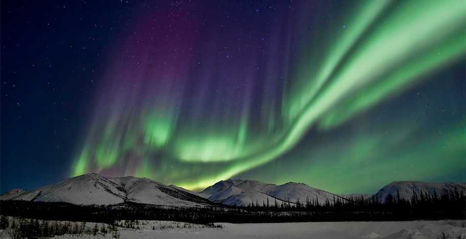
From mid-August, you have the chance to see the Aurora Borealis. Autumn colors also begin in mid-August. You can admire fall colors until the end of September. Unless winter starts at the end of August and the first snow falls.

Weather and Temperatures on Dalton Highway Alaska in Summer
In August 2022, we experienced almost all seasons on Dalton and nearly all road conditions. We had completely different weather forecasts. Therefore, regardless of the weather forecast, you must be prepared for all situations: rain, snow, fog, mud, wind, and ice. Everything is possible on Dalton Highway.
On the hottest day during our Dalton trip, we had 68°F (20°C). Mornings were cool, around 41-45°F ( 5-7°C). The average temperature during the day was 59-65°F (15-18°C). Our coldest and windiest morning was in Deadhorse when we drove with an authorized tour to the Arctic Ocean to 34°F (1°C). There was also a frost at the Atigun Pass the night before our trip to the Arctic Ocean at 30,2°F (-1°C).
In Deadhorse, at Prudhoe Bay, average summer temperatures are in the 30s and 40s°F (0-5°C). Average temperatures south of the Brooks Range and in Coldfoot during Summer are 50s°F (10-15°C).

Summer Solstice
Summer is also a great time to visit as the sun hardly ever sets. It is a very long day. Summer solstice at the Arctic Circle is fantastic, as the sun doesn’t set! This is the place where the sun doesn’t set on summer solstice and doesn’t rise on winter solstice.
From 21 of June, the day is very long. During our trip in August, even at 1 am was bright, and the visibility was excellent. So traveling between June 21 and mid-August is perfect as you have long days. The summer solstice also makes spending the night in this wilderness and emptiness easier.
Can you drive the Dalton Highway in Alaska in Winter?
BLM does not advise travel between October and April. But the Dalton Highway remains open in winter. However, winter driving conditions are hazardous. Moreover, winter temperatures are extremely low, dropping even -70°F (-57°C).
The coldest temperature ever recorded in the United States was -80°F (-62°C) at Prospect Camp, 39 miles south of Coldfoot, in 1971. On January 28, 2012, an unofficial temperature of -79°F (-62°C) was recorded at the nearby Jim River Maintenance Station. Then the weather station battery died.
Snow, frost, and powerful winds can make it impossible to travel. The road surface and conditions can be extremely dangerous. In winter, this route is still traversed by huge trucks delivering supplies to the Deadhorse and oilfields. They cannot slow down in time if you suddenly stop on the road.
We experienced terrible weather on this route in summer for two days, and we know how difficult it can be to drive. So, we do not recommend a winter trip. Of course, some daredevils have traveled this route in winter. But because we made this trip in the summer, we give you only tips for summer adventure based on our experiences.

How Long Does it Take to Drive the Dalton Highway?
It all depends on the weather, conditions on the road, and what goals you have. Do you just want to drive this route? Or do you also want to experience this one of the world’s most lonely and distant roads? We spent 10 days on Dalton Highway to experience its beauty and wildness and get to know the attractions. Our goal was also to see the Gates of the Arctic National Park .
But we know that not everyone has so much time, so we have prepared a 7-day Dalton Highway itinerary, day after day, with the most exciting attractions and things to do along the way.
We think the minimum time you should reserve for the roundtrip safe drive on Dalton Highway is at least four days . Assuming that the weather will be good and favorable to the drive. If you don’t have that much time, consider a drive to the Arctic Circle only as a one-day trip from Fairbanks.
Or consider an organized trip with an experienced driver and guide from Fairbanks to the Arctic Circle or from Fairbanks to Prudhoe Bay. Another option to see Dalton Highway is the scenic flight from Fairbanks. If you want to reach only the Arctic Circle, which is a great adventure, check out the best Arctic Circle trip from Fairbanks .
The approximate driving time from Fairbanks to Prudhoe Bay without stops
- Yukon River – 3 hours
- Arctic Circle – 5 hours
- Coldfoot – 6 hours
- Antigun Pass – 8 hours
- Deadhorse – 14 hours
Dalton Highway Gas Stations
Driving the Dalton Highway is a challenge not only because of the difficult driving conditions. One of the biggest problems on this route is access to gasoline. As there is no easy access. There are only three places with gas stations on the entire Dalton Highway where you can refuel.
In addition, it will be the most expensive gasoline in the United States ! You will travel 414 miles one way along the pipeline that transports over 700,000 barrels of oil per day, but there are only three fuel stops. What’s more, you will pay at least $3 more per gallon than the national average. Include this carefully in your budget for Dalton Highway.
It’s a good idea to pack an extra tank with fuel. Also, before you leave Fairbanks, refuel the tank and then fill it up to full at each station. Hilltop Truck Stop in Fox is the last gas station when you leave the Fairbanks area. It’s located on Elliot Highway, 16 miles north of Fairbanks.
There are only three places with gas stations along the Dalton Highway
- Yukon River Crossing (Mile 56; only open from Mid-May to Mid-September)
- Coldfoot which offers excellent outdoor activities (Mile 175)
- Deadhorse (Mile 414; gasoline is available from three stations).
Dalton Highway Camping & Lodging
Another topic you need to consider when planning your trip through the Dalton Highway is accommodation. This is an adventure for people who like challenges and do not mind the lack of amenities, warm water, or a comfortable bed. There are only a few places on the route where you can stay overnight.
Lodges on Dalton Highway, Alaska
If you dream about a comfy and soft bed along the way, you don’t have too many choices. First, you must book your room months in advance, and secondly, the prices are pretty high in this remote area. And don’t expect a high standard. You will find lodges at Yukon River Camp , Inn at Coldfoot Camp , and the charming Arctic town of Wiseman ( Arctic Getaway and Boreal Lodging ). Few hotels you will find in Deadhorse at Prudhoe Bay.

Campgrounds on Dalton Highway, Alaska
If you are traveling in an RV or planning to sleep in a tent (as we did), you can stop at four campgrounds managed by BLM. There are no electricity and no bathrooms with showers. They only have vault toilets, and 3 have potable water—more details and photos can be found in our article Dalton Highway Camping .
- Five Mile Campground – at Milepost 60
- Arctic Circle Campground – at Milepost 115
- Marion Creek Campground – at Milepost 180 (5 miles north of Coldfoot)
- Galbraith Lake Campground – at Milepost 275
Camping on Public Lands
You can also pitch your tent or park your RV on public lands managed by BLM . However, as long as you stop at a safe distance from the road without endangering the traffic on the road or obstructing it.
It would be best to park well off the road, as passing vehicles can fling rocks more than 30 feet (9 m) off the highway. And you can’t block access roads to the pipeline. It’s not allowed to stop on the access roads. Camping is limited to 14 days at any one spot.
Honestly? On this route, finding a comfortable and safe place to stay outside designated areas is difficult. More details can be read in the article about camping on Dalton Highway.
PRO TIP: Whichever type of accommodation you choose, be sure to follow the Leave No Trace rules . Respect nature, respect wildlife, respect the rules on the road, and always take all the trash with you.

Pit Stops along the Dalton Highway, Alaska
A separate article is written about activities, best pit stops, and places worth seeing on the Dalton Highway. Here, to make planning your travel more manageable, we will mention that you have a few places on the route between Fairbanks and Deadhorse where you will meet people and find some services.
- At milepost 56 is Yukon River Camp . It’s 137 miles north of Fairbanks. Yukon River offers gas, a cafe, and limited lodging. It’s open only from mid-May to mid-September.
- At milepost 175 is Coldfoot Camp . We love this place. It’s 256 miles north of Fairbanks, with gas, a cafe with great food, and a motel. Here, you can also take a scenic flight over the Brooks Range or a trip to the Gates of the Arctic National Park. It’s also where you can find the Arctic Interagency Visitor Center , where you can learn much about the area. Plan some activities in Coldfoot Camp.
- At milepost 186 is the turnoff for Wiseman . It’s a fantastic, charming village from the Gold Rush times—pictures and details we put in this separate post about the remote Arctic town of Wiseman. But you won’t find any services here except for two lodges.
- At milepost 414 is Deadhorse , which is “company town,” is amid the Prudhoe Bay oilfield and boasts a non-permanent population of 2,000-3,000 employees of the various oil operations. The Dalton Highway ends just a few miles before the Arctic Ocean, and only private, restricted roads extend to the ocean. You will find three gas stations, some lodgings, one store, and some hotel restaurants.

Dalton Highway Tours
If you do not want to set off on the Dalton Highway on your own but dream of crossing the Arctic Circle and seeing at least a piece of this highly picturesque route, consider one of the following organized tours.
Arctic Circle Full-Day Guided Trip from Fairbanks
During this one-day guided trip , you will step across the Arctic Circle, see the Trans-Alaskan Pipeline, and discover the Yukon River and Finger Mountain.
Please enter the date of the planned trip and the number of participants below to check its availability and price.
Northern Lights and Arctic Circle Tour from Fairbanks
If you plan to visit Alaska during the Aurora Borealis (Northern Lights) season, you can go on a Northern Lights and Arctic Circle trip from Fairbanks, where you will cross the Arctic Circle on Dalton Highway. But no tour operator can guarantee you will see the Northern Lights. It’s the magic of nature; it depends on many factors.
You can spend even a week or two in a season and not see it, and maybe one night is enough, and the Northern Lights will dance in the sky for you. Enter your trip date to check its availability and price. Aurora Season in Alaska is from August 21 to April 21 . But it happens that the Aurora can already be seen in mid-August.
Wildlife and Activities along the Dalton Highway, Alaska
The Dalton Highway is not just a road. This route allows you to admire nature and landscapes, observe wildlife, and do numerous activities. You can go hiking, fishing, backpacking, or kayaking. You can take a scenic flight over the Brooks Range, the Gates of the Arctic National Park, and more.
There are a lot of activities, so we have prepared a separate article about them with a detailed description. We also provide details on safety, especially regarding the bears’ encounter. One of the great stops along the road is the Visitor Center in Coldfoot.
Points of Interests along the Dalton Highway, Alaska
Below, we present a list of the most exciting points of interest along the Dalton Highway with the milepost (MP) on which it is located. It is worth stopping by them. Driving the Dalton Highway in Alaska is full of unique places.
- MP 0 – The beginning of the Dalton Highway. Reset the counter here so as not to miss the exciting places along the route. For the next 414 miles, you may have little or no internet access.
- MP 56 – Yukon River Crossing
- MP 60 – Five Mile Campground
- MP 98 – Finger Mountain
- MP 115 – Arctic Circle sign
- MP 132 – Gobblers Knob
- MP 150 – Grayling Lake Wayside
- MP 175 – Coldfoot Camp
- MP 180 – Marion Creek Campground

- MP 189 – Wiseman
- MP 204 – Sukakpak Mountain
- MP 237 – Chandalar Shelf
- MP 244 – Atigun Pass (elev. 4,739 feet / 1422 m)
- MP 275 – Galbraith Lake Campground
- MP 284 – Toolik Lake
- MP 300 – Slope Mountain
- MP 334 – Happy Valley
- MP 348 – Sag River Overlook
- MP 383 – Franklin Bluffs
- MP 414 – Deadhorse and Prudhoe Bay

Do you like it? Pin it!

Agnes Stabinska is the creative force and co-founder behind the Alaska Itinerary blog. With a degree in Tourism Management and postgraduate studies in Journalism, Agnes combines academic expertise with real-world experience. Alongside her partner, Chris, she's your go-to guide for an authentic Alaskan adventure.
Agnes doesn't just write about Alaska; she lives it. From capturing the state's breathtaking landscapes through her lens to hiking its rugged trails or observing bears and whales in their natural habitat, her firsthand experiences are your compass to all things Alaska.
With Agnes and Chris, you're not just reading another travel blog; you're tapping into a treasure trove of insider tips, curated itineraries, and invaluable insights to make your Alaskan journey truly unforgettable.
Similar Posts

Exploring the Quirky Town of Chicken in Alaska
Share on X (Twitter) Share on Facebook Share on Pinterest Share on EmailIn the heart of Alaska’s wild expanse…

One Day In Skagway: Itinerary For Cruise Passengers
Share on X (Twitter) Share on Facebook Share on Pinterest Share on EmailDiscover the wonders of Skagway in just…

Hatcher Pass Alaska: Planning Your Perfect Adventure
Share on X (Twitter) Share on Facebook Share on Pinterest Share on EmailAre you planning a trip to Hatcher…

25 Top Things to do in Talkeetna
Share on X (Twitter) Share on Facebook Share on Pinterest Share on EmailHere’s our go-to guide for the ultimate…

Facts about Icy Strait Point
Share on X (Twitter) Share on Facebook Share on Pinterest Share on EmailDid you know that Icy Strait Point…

When is The Best Time to Visit Fairbanks, Alaska?
Share on X (Twitter) Share on Facebook Share on Pinterest Share on EmailPlanning on an adventure to the heart…
Wow, this is one of the best and most comprehensive travel blogs I have ever come across. Having traveled all 7 continents and lived abroad, this blog contains everything one could need to plan a journey on the Dalton Highway! My family and I plan on doing a single day trip to the Arctic Circle and back to Fairbanks this coming June, and the information here made me realize how remote the haul is and how much one needs to prepare for even a one day journey. Thank you!
Thank you so much for your kind words! We’re thrilled to hear that our guide to the Dalton Highway has been so helpful in planning your adventure. It’s great that you’re taking the family on this unique journey to the Arctic Circle. June is a fantastic time to travel, with the midnight sun offering extended daylight for your trip. Feel free to reach out if you have any more questions or need further tips. Happy travel!
How is Dalton Highway from Fairbanks to the Artic Circle? Is it paved most of the way? We were hoping to rent a car and drive it ourselves. We are country folks from Iowa and we have experience on gravel roads. Just was worried about how much of it is actually paved. Thanks.
Thank you for your comment, Carol. From Fairbanks to the Arctic Circle sign, it’s 195 miles and about a 5-6 hour drive without stops. Of course, driving time may be significantly longer in bad weather. Dalton Highway begins 84 miles north of Fairbanks. And at this point, it’s a gravel road. So you have 110 miles to ride on gravel. As we wrote in the article, most rental companies prohibit driving on this road. So check carefully whether you can drive on this road with your rental car. In the article, I list rental companies that allow driving on this route. We had a car from Alaska Auto Rental in Fairbanks. When renting a car, you must indicate that you want to drive on this road. Have a great trip!
Leave a Reply Cancel reply
Your email address will not be published. Required fields are marked *
Save my name, email, and website in this browser for the next time I comment.
Arctic Circle Aurora Overnight Adventures
Find Your perfect trip
When will you come?
What do you want to see?
Coldfoot's far north location places it one of the world's best aurora viewing areas.

Tour Summary
The Arctic Circle Aurora Overnight Adventure departs from Fairbanks by land or air and offers optional aurora viewing, dog sledding, and Brooks Mountain Range excursions from your base camp at Coldfoot, Alaska.
- Learn the fascinating story of Alaska's Arctic from your guide. Travel through mining areas north of Fairbanks.
- View the remarkable Trans Alaska Pipeline.
- Travel the famed Dalton Highway. Traverse the mighty Yukon River.
- Cross the Arctic Circle and receive an official Arctic Circle Adventure Certificate.
Coldfoot's far north location places it one of the world's best aurora viewing areas. For more information about the aurora, please visit our Frequently Asked Questions. Also, you can visit the University of Alaska Fairbanks Geophysical Institute website .
Accommodations: Located halfway between Fairbanks and Prudhoe Bay, Coldfoot Camp provides an excellent base for travelers in Alaska's Brooks Mountain Range. Although rustic by urban standards, Coldfoot Camp is clean and each room features two twin beds and private bath facilities in each of the rooms, a luxury in the remote wilderness of Alaska's Arctic.
A round trip journey by land and air exploring Alaska's Brooks Mountain Range.
This adventure is for those who are serious about looking for the Aurora. To increase the odds of seeing them one should stay put for multiple nights in a location as close to the source of the lights as possible so that even on a quiet night the ability is there to see them. Quiet doesn't mean they are not occurring, quiet means the band they occur in is narrow and not visible miles away.
Tour Dates and Rates
August 21, 2024 - September 16, 2024
9:45 AM Departure
Days: Daily
Rate: $869 *
* Per person based on double occupancy for a 3 day / 2 night Adventure. Single Supplement $200
September 19, 2023 - October 7, 2023
November 18, 2023 - November 26, 2023
December 16, 2023 - January 2, 2024
February 10, 2024 - February 29, 2024
March 1, 2024 - March 31, 2024
Days: Sunday Friday
Rate: $1039 *
* Peak Rate based on double occupancy for a 3 day / 2 night adventure. Single Supplement $200
October 8, 2023 - November 17, 2023
November 27, 2023 - December 15, 2023
January 3, 2024 - February 9, 2024
April 1, 2024 - April 21, 2024
Rate: $889 *
* Standard Rate per person based on double occupancy for a 3 day / 2 night adventure. Single Supplement $200
- Arctic Circle
- Yukon River
TOUR SUMMARY:
- Ground tour in the personalized comfort of our ground tour vehicles. Appreciate the low light on the horizon as it shines on the windswept arctic tundra. Traverse the frozen Yukon River and enjoy the snow-sculpted forest as you make your way across the Arctic Circle. Arrive in Coldfoot and settle in for your 3 night stay.
DAY 2 (or more if staying more than 2 nights)
- Select from a variety of optional tours which include an excursion along the Dalton Highway, into the Brooks Mountain Range, as far north as Atigun Pass (weather permitting); a one-hour dog sledding experience with a local musher, and additional aurora viewing in Wiseman (optional tour prices are not included).
DAY 3 - or last day if staying longer!
- Depart Coldfoot by air for Fairbanks. Average time of return to Fairbanks is 4:30 PM, average flight time is 70 minutes. Departure time can vary based on number of guests and flight resources on day of travel. Most common time of departure is 3:00 PM but can range from 10:00 AM to 4:00 PM.
Departs 9:45 am by ground tour on DAY 1; Depart Coldfoot by air on your final day (average time of return to Fairbanks is 4:30 pm. Departure time can vary based on number of guests/flight resources on day of travel). Most common departure time from Coldfoot is 2:30 pm but can range from 10:00 am to 4:00 pm.
MEALS are not included; however, on day 1 we will make a quick stop at a grocery store for you to get food for lunch and all other meals at the Coldfoot Camp Trucker's Cafe ( Menu as of 3/23/23 ).
LUGGAGE : For your small plane flight, you are allowed to bring up to 20 pounds per person. Your luggage should be in a carry-on size and soft-sided bag, like a backpack, duffle, or tote bag. Nothing on wheels. We will weigh all of your bags (overnight and day bags) at the time of check in.
All per person based on double occupancy.
Single Supplement add $100 per night.
3 Day / 2 Night - Departs FRIDAY and SUNDAY = $889/ PEAK = $1039
4 Day / 3 Night - Departs TUESDAY = $989 / PEAK = $1139
5 Day / 4 Night - Departs FRIDAY = $1089 / PEAK = $1239
6 Day / 5 Night - Departs TUESDAY and SUNDAY = $1189 / PEAK = $1339
PEAK DATES:
September 19 - October 7, 2023
November 18 - 26, 2023
February 10 - March 31, 2024
For an Arctic Circle Aurora Overnight Adventure Tour Program click HERE .
OPTIONAL TOURS - available for purchase
We recommend you pre-book any activity you know you want to do. Coldfoot will do their best to accommodate on site reservations; however, not always will you be able to make reservations once in Coldfoot due to space or guide availability.
Arctic Mountain Safari: Enjoy an afternoon exploring the Brooks Mountain Range on a guided ground tour north from Coldfoot on the Dalton Highway as far north as Atigun Pass (weather permitting). Departs Coldfoot at 10:00 am and returns at 6:00 pm. Meals not included. Box lunch can be purchased at Coldfoot Camp.
- $129/ person
Arctic Snowshoe Outing : Enjoy a guided snowshoe outing on a trail near Clara Creek. The excursion lasts about 2 hours with about 1 hour of snowshoeing (between 1 - 2 miles) Hot drinks included. Departure times vary.
- $39 / person
Arctic Village Aurora: Enjoy an evening tour to historic Wiseman for a unique cabin visit and an opportunity to enjoy the solitude of the Brooks Mountain Range as you scan the northern sky for Northern Lights. Cabin visit includes complimentary hot beverages. Departs Coldfoot at 10:00 pm and returns at 2:00 am.
- $89 / person
Dog Sled Adventure: Enjoy an afternoon with real Alaskan sled dogs. Learn what it takes to have a dog team in Alaska. Enjoy a ride, and, if you wish, drive a team of your own. Times will vary and will be arranged by the guide in Coldfoot to fit within your schedule - experience takes approximately 1 hour.
- $189 / person ( Only available December 15 - March 31 - booked only once at Coldfoot Camp.)
Fat Tire Bike Adventure: Explore the beautiful Coldfoot wilderness area on a fat tire bike. Trip is 6 miles following Slate Creek on an old and rugged (but maintained) gold mining trail. Bikes and helmets are provided. Lasts approximately 2 hours.
For information on how to make a reservation, click on the link to our planning page.
Recommendations : For any of our adventures into Alaska's Arctic we recommend planning to arrive in Fairbanks the night prior to joining us and stay in Fairbanks the night returning with us. If you are delayed arriving into Fairbanks and miss your tour departure that equals a non-refundable cancellation. We will do our best to see if there is an alternate available for you; however, there is no guarantee of an equal replacement nor is the tour refundable if missed.
NOTE: Guest safety always takes precedence over convenience. The return on the final day is by small plane. Small plane flying in Alaska's Arctic can be delayed or even cancelled on occasion due to weather. If the weather requires us to alter the return method of travel from air to ground it will be done as an equal exchange of travel.
Alaska's Arctic -- premier destination to look for the Aurora -- Coldfoot is located directly under the Aurora Oval, where the aurora originate in the northern hemisphere.

Scene from Coldfoot Camp

Winter In Alaska's Arctic Dalton Highway South Of The Eyukon River

Denali Winter Drive Adventure
A One Day Guided Round Trip Journey By Land To North America's Tallest Mountain
- Χ Arctic Circle
- Χ Arctic Ocean
- Χ Polar Bear
- Χ Undiscovered Arctic
- Χ Yukon River

Denali WINTER Summit Flight (from Fairbanks)
Thrill at the excitement of witnessing firsthand Denali, North America's tallest mountain, by air from a unique perspective - eye level!
National Geographic content straight to your inbox—sign up for our popular newsletters here

Road Trip: Dalton Highway, Alaska
A mostly gravel road does not do justice to the vastly dramatic scenery that lies along its winding path.
The 414-mile (666-kilometer) road from Livengood to Prudhoe Bay, Alaska, carves a path through forest and tundra, crosses the Yukon River, traverses the towering Brooks Range, and passes over the North Slope to end at the Arctic Ocean.
The Dalton Highway slices through northern Alaska from Livengood to the oil fields of Prudhoe Bay. Built in 1974 as the service road for the Trans-Alaska Pipeline, the highway is not to be taken lightly. It's a mostly gravel thoroughfare often ruled by 18-wheelers. Services are few, and signs warn of everything from steep grades to avalanches. However, the signs say little of the road's chief attribute: some of North America's most dramatic scenery.
Start in Fairbanks
In Fairbanks, load up with gas, water, food, and spare tires and head north 84 miles (135 kilometers) to Livengood. This is Alaska's Interior—gently rolling hills of aspen, scrawny black spruce poking through mossy bogs, and meandering streams. Your constant companion is the 48-inch (122-centimeter) pipeline carrying oil from the North Slope to Valdez. Near the Yukon River, satisfy a big appetite with big burgers at the scruffy Hotspot Café.
Yukon River
Moving on, watch for dramatic changes. A favorite stretch of the highway for many falls between the Yukon River and the Arctic Circle, where you encounter tundra and taiga, with evocative granite outcrops around Finger Mountain. Stay alert for sightings of grizzly and black bears. Sometimes, large herds of caribou may cross the highway. Remain inside your vehicle whenever you spot wildlife, since the vehicle serves as a blind and is the safest place to observe animals.
At mile 175, fill up your tank at the truck stop in Coldfoot, offering the last services for the next 240 miles (386 kilometers). Then head into the Brooks Range, where sky-stabbing spires of bare rock tower over 7,000 feet (2,134 meters). As the road drops, it skirts the Arctic National Wildlife Refuge ( arctic.fws.gov ), home to caribou and the nesting ground for millions of migratory birds. An impressive 158 species have been recorded in the region, and many birds can be seen along the highway, from songbirds to flocks of migrating waterfowl to shorebirds, raptors, and rare species from Asia and Africa such as yellow wagtails and wheatears.
Brooks Range
For hikers, the Brooks Range is a great place to park your vehicle and stretch your legs. According to the Bureau of Land Management, ridges and stream drainages here "provide firm footing and the forest thins to low-growing tundra. Throughout the Arctic, wetlands and bogs hinder walking. Areas of tussocks—sedges that grow in basketball-sized clumps—are particularly aggravating. Tussock fields occur in mountain valleys and dominate the landscape of the North Slope. Waterproof boots with good ankle support are essential." East of the highway you'll come to the Arctic National Wildlife Refuge, while to the west you'll find the Gates of the Arctic National Park and Preserve ( www.nps.gov/gaar ). The BLM advises hikers to "Choose your route with care and bring topographic maps and a compass with you. A GPS can also be useful, especially when visibility is poor." Backcountry hikers should register at the visitor center in Coldfoot, where they can borrow storage barrels to protect their food from bears. A BLM note about the area: "Magnetic declination varies from 27 to 30 degrees east of true north; be sure to adjust your compass."
Atigun Pass
Atigun Pass (elevation 4,739 feet/1,444 meters) is the only mountain pass in the Brooks Range crossed by a road, and it's also the highest pass in Alaska to be kept open year-round. South of Atigun Pass, you can search for gold on BLM-managed public lands, using a pan, pick, shovel, or rocker and sluice box. To find out the best places to go for the gold, ask for the brochure "Dalton Highway Recreation Mineral Collection" at the BLM office or Alaska Public Lands Information Office in Fairbanks, the Yukon Crossing Visitor Contact Station at milepost 56, or the Arctic Interagency Visitor Center in Coldfoot at milepost 175.
- Nat Geo Expeditions
The Dalton Highway ends at Prudhoe Bay, which is the largest oil field in the United States. The company town here is called Deadhorse. You can tour the oil fields and dip your feet in the Arctic Ocean. Anglers can fish for Arctic grayling, whitefish, Dolly Varden, Arctic char, lake trout, burbot, and northern pike, though catch-and-release fishing and the use of barbless hooks are encouraged. Fishermen require an Alaska sport fishing license and a regulations booklet for the Arctic-Yukon-Kuskokwim region. See the Alaska Department of Fish and Game website ( www.adfg.state.ak.us ) for a list of regulations or pick up the free brochure "Sport Fishing Along the Dalton Highway" at BLM visitor centers. After your stay in a former construction camp in Deadhorse, you can look forward to seeing the Dalton Highway all over again from the opposite direction on the long drive home.
June to mid-July is the ideal time for driving this route. For general information on the Dalton Highway, see www.blm.gov/ak/st/en/prog/recreation/dalton_hwy.html . See The Milepost travel guide ( milepost.com ) for general trip-planning information. You can camp for a fee at the Bureau of Land Management's Marion Creek Campground just north of Coldfoot; elsewhere, all other camping areas are free, though undeveloped. RVers note: Dumping stations are available only at Deadhorse and at the mile 60 campground just north of the Yukon River. Repair services are available only at Yukon Crossing (summer only), Coldfoot, and Deadhorse, and there are no medical facilities along the highway. In an emergency, contact state troopers by phone (911) or via CB radio (channel 19). Note: Cell phone coverage is spotty or nonexistent along most of the route. There are several enjoyable river trips just off the highway, including the Jim River, Middle Fork of the Koyukuk River, and the Sagavanirktok River. Contact the Arctic Interagency Visitor Center in Coldfoot for details (tel. 1 907 678 5209; [email protected] ; www.blm.gov/ak/st/en/prog/recreation/dalton_hwy/dalton_viscenters.html ).
—Text by Carol Sturgulewski
Related Topics
- HIGHWAYS AND ROADS
You May Also Like

25 essential drives for a U.S. road trip

Route 66: America's most celebrated road trip is going electric
Free bonus issue.

From ice roads to the Klondike Highway: 6 of Canada's most adventurous road trips

How to plan the ultimate road trip adventure in Canada

Lobster, lighthouses and sea breezes on a road trip in nautical Nova Scotia

See monarch butterflies in all their glory on this California road trip

Is this the ideal Swiss road trip?
- Environment
- Perpetual Planet
History & Culture
- History & Culture
- Mind, Body, Wonder
- Paid Content
- Terms of Use
- Privacy Policy
- Your US State Privacy Rights
- Children's Online Privacy Policy
- Interest-Based Ads
- About Nielsen Measurement
- Do Not Sell or Share My Personal Information
- Nat Geo Home
- Attend a Live Event
- Book a Trip
- Inspire Your Kids
- Shop Nat Geo
- Visit the D.C. Museum
- Learn About Our Impact
- Support Our Mission
- Advertise With Us
- Customer Service
- Renew Subscription
- Manage Your Subscription
- Work at Nat Geo
- Sign Up for Our Newsletters
- Contribute to Protect the Planet
Copyright © 1996-2015 National Geographic Society Copyright © 2015-2024 National Geographic Partners, LLC. All rights reserved

An official website of the United States government
Here’s how you know
Official websites use .gov A .gov website belongs to an official government organization in the United States.
Secure .gov websites use HTTPS A lock ( Lock A locked padlock ) or https:// means you’ve safely connected to the .gov website. Share sensitive information only on official, secure websites.
Open Search
Mobile Menu
Dalton Highway
The Dalton Highway stretches 414 miles across northern Alaska from Livengood (84 miles north of Fairbanks) to Deadhorse and the oilfields of Prudhoe Bay. Built to allow for construction of the trans-Alaska oil pipeline in the 1970s, this mostly gravel highway travels through rolling, forested hills, across the Yukon River and Arctic Circle, through the rugged Brooks Range, and over the North Slope to the Arctic Ocean.
The BLM manages a swath of public lands along the highway from the Yukon River to the north side of the Brooks Range. Within the Dalton corridor, the BLM maintains campgrounds, rest areas, interpretive panels and the Arctic Interagency Visitor Center in Coldfoot.
Visit the Arctic Interagency Visitor Center website at https://www.blm.gov/learn/interpretive-centers/arctic-interagency-visitor-center
Know Before You Go
This is no ordinary road -- it pays to be prepared. The road is narrow, rough, steep, and mostly gravel -- prone to clouds of dust, slick mud, and sudden potholes. It’s still primarily an industrial corridor, with heavy truck traffic, though drivers also need to keep an eye out for motorcycles, bicyclists, and wildlife crossings. North of Coldfoot, you may encounter snow and ice any month of the year. Lightning-caused wildfires are increasingly common. Cell phone service is extremely limited. Currently, only GCI and AT&T are available in Coldfoot and scattered locations along the highway. There are no medical facilities or grocery stores.
Before you embark on this incredible journey, be sure to check your vehicles tires and fluids, carry extra motor oil and a spare tire(s), and if possible utilize a CB radio tuned to channel 19. Check travel conditions and alerts at 511.alaska.gov .
Recreational Activities
From hiking to boating, gold panning to wildlife-watching, there are numerous opportunities for recreation alongside the Dalton Hwy. The BLM maintains 4 developed campgrounds, each open late May through early September. Visit https://www.blm.gov/central-yukon-fo/public-room/fact-sheet/dalton-highway-campgrounds for more information. Note that Alaska State statutes prohibits use of off road vehicles, including snowmachines, for 5 miles on either side of the Dalton Hwy, north of the Yukon River. Alaska Department of Fish and Game allows only bow hunting within 5 miles either side of the Dalton Hwy north of the Dalton Hwy as well.
Pack it In, Pack it Out
The BLM hauls approximately 20 tons of litter from the Dalton Highway back to Fairbanks (the nearest landfill) each year. Please help reduce waste and litter by packing out everything you pack in.

Flickr Album

DALTON HIGHWAY QUICK LINKS
- Dalton Highway Visitor Guide (3.5 MB)
- Georeferenced PDF Map of the Dalton Highway Corridor - Fairbanks to Coldfoot (18.4 MB)
- Georeferenced PDF Map of the Dalton Highway Corridor - Coldfoot to Deadhorse (17.3 MB)
- Arctic Interagency Visitor Center
Geographic Coordinates
From Fairbanks, drive north on the Steese (AK-6) and Elliott (AK-2) Highways. At Elliott Highway mile 73.1, stay right to get onto the Dalton Highway (AK-11).
External Map
Experience True Nature
Wilderness adventure tours beyond imagination, northern lights tour - arctic circle & chena aurora viewing (nl#02), tour itinerary, dates | rates, options | extensions, northern lights faq.
▶ Northern Lights Viewing in Alaska | Canada – New Moon Dates Overview
Ideal viewing time is approximately from 7 days prior to New Moon and until 7 days after New Moon. While some people may be concerned that a full moon is a problem, only weak aurora may be obstructed by the light of the moon, but in Alaska the aurora is frequently strong enough that aurora viewing is still possible on a moonlit night. As far as aurora photography goes, the aurora above a moonlit landscape actually tends to have a pleasing effect. On the whole, when participating in an aurora tour, one doesn’t need to be worried about the moon.The moon does not influence the aurora activity, the sky is just darker. You can therefore travel any time of the month.
Aurora Photography: When you do your research for shooting the aurora, you’ll find pluses and minuses for going when a full moon is present. On the minus side is if the lights that night are somewhat faint, the brightness of the moon’s reflection of the sun can fade them out. On the other hand, a full moon can be used to illuminate objects in the foreground. Many aurora shots include buildings with lights on inside to provide an interesting foreground subject. Depending on your shooting location, this feature might not be available. However, a full moon will help light up anything you have in front of you, no matter where you are. Because shots are done for at least six to eight seconds and up to fifteen seconds or more (depending on your shutter and ISO settings), the full moon will do a great job of making what would otherwise be a silhouette into a well-lit subject. Conversely, if you choose to go when there isn’t a full moon, a strong flash can be helpful in popping light onto a foreground subject.
▶ Aurora Viewing | Prime Viewing Dates
Q: When is the best time of the year to see the Aurora A: In northern regions such as Alaska, the Yukon Territory, Northern British Columbia and the Northwest Territories - the Northern Lights (Aurora Borealis) are seen from late August to mid April. Furthermore, during the autumn and spring, the weather is rather unstable and has a lower percentage of clear skies. Therefore, we have determined the best viewing seasons to be from mid-August to the end of September and from mid-November to mid-April. In This time of the year offers the best trade off between mild weather and dark skies. During the summer months, night skies are not dark enough to view the Aurora Borealis and in midwinter temperatures in the – 40 degree range make outdoor aurora viewing somewhat unpleasant. In other locations farther from the average aurora oval, the main consideration is the level of geomagnetic activity, which varies rather unpredictably through the year. Q: When is the best time of the day A: Within the most active regions of Alaska and prime viewing areas the Aurora oval typically becomes visible around local midnight. Note: this is an astronomical midnight - which may be an hour or two different from the civil or the “ wall clock “ midnight due to daylight savings time and/or peculiarities in your time zone. Spectacular Aurora displays due to geomagnetic disturbance may be seen at any time when the sky is dark, but they are relatively unpredictable. Under average conditions, observations around local midnight are most likely to yield results. Q: What are the Temperatures in the Northern Regions A: The average daily temperatures in February/March are approximately +20/-30 - equivalent to –8/-33 degrees Celsius.
Q: How to observe the Aurora A: If you follow our recommendations you should be able to enjoy some pleasant Aurora viewing.
- A: Ensure - that you be there when the action begins. Because more often than not, the show picks up very quickly and also fades out as quickly as it started! Most of the auroras are out only about 2 to max 10 minutes at ones.
- A: Be Patient - this is maybe the most important thing in aurora viewing. If the show starts, it's always worth. Seeing a full-blown aurora show is just an indescribable experience.
- A: Experience - this is maybe the second most important (human) factor in aurora viewing. If you are first patient and then successful in seeing auroras, the direct consequence is that you will gain of course - experience. After a while you will begin to recognize what the aurora is doing, in which phase it is and so on. And the most important thing - You will learn how a weak aurora looks like!!! Because, even that we are hoping to see a bright "eruption phase " aurora, the aurora isn't all the time bright. So the experience will help you to see and determine if there is a weak aurora, which could get brighter in the future! I
- A: Light Conditions - the primary reason for not seeing an aurora are any city light obstruction or a bright twilight. Our destinations are far away from a city or other light obstruction and therefore should guarantee the best viewing conditions possible.
- A: Weather - don't think overcast weather prevent you from Aurora viewing. Although often clouds do ruin everything, but at times...you can also get lucky breaks! Another example, during a major aurora storm in 2001 the forecasts and satellite pictures showed that it should be overcast, but it was not. We could see the stars and the aurora through the thin clouds! So, give it a try anyway...it could be worth it!
Q: What causes the Aurora A: Energetic charged particles from the magnetosphere. These particles are electrons and protons that are energized in the near geo-space environment. This energization process draws its energy from the interaction of the Earth's magnetosphere with the solar wind. The magnetosphere is a volume of space that surrounds the Earth. We have this magnetosphere because of Earth's internal magnetic field. This field extends to space until it is balanced by the solar wind.
Q: What is the altitude of the Aurora Borealis A: The bottom edge is typically at 100 km (about 60 miles) altitude. The aurora extends over a very large altitude range. The altitude where the emission comes from depends on the energy of the energetic electrons that make the aurora. The more energy the bigger the punch, and the deeper the electron get into the atmosphere. Very intense aurora from high-energy electrons can be as low as 80 km (50 miles). The top of the visible aurora peters out at about 2-300 km (120-200 miles), sometimes high altitude aurora can be seen as high as 600 km (350 miles). This is about the altitude at which the space shuttle usually flies.
▶ Sun | Solar Wind | Magnetosphere
The solar wind is the outermost atmosphere of our sun. The sun is so hot that it boils off its outer layers, and the result is a constant outward expanding very thin gas. This solar wind consists not of atoms and molecules but of protons and electrons (this is called a plasma). Embedded in this solar wind is the magnetic field of the sun. The density is so low that we may well call it a vacuum. However tenuous it is, when this solar wind encounters a planet, it has to flow around it. When this planet has a magnetic field, the solar wind sees this magnetic field as an obstacle, as protons and electrons cannot move freely across a magnetic field. These charged particles are constrained to move almost always only along the magnetic field. Likewise, when they are forced to move in a specific direction, a magnetic field will move with them or will be bent into the direction of the flow. Whether the magnetic field forces the plasma motion or whether the plasma motion bends the magnetic field depends on the strength of the field and the force of the motion. When the solar wind encounters Earth's magnetic field, it will thus bend the field unless the field gets too strong. The strength of the magnetic field falls off with distance from Earth. The distance at which the solar wind and the magnetic field of the Earth balance each other is about 60,000 km away, or 1/10 of the distance to the moon. The inside of this volume that is bounded by the solar wind is called the magnetosphere. At the interface of the solar wind and the magnetosphere, energy can be transferred into the magnetosphere by a number of processes. Most effective is a process called reconnection. When the magnetic field in the solar wind and the magnetic field of the magnetosphere are anti-parallel, the fields can melt together, and the solar wind can drag the magnetospheres field and plasma along. This is very efficient in energizing magnetospheres plasma. Eventually, the magnetosphere responds by dumping electrons and protons into the high latitude upper atmosphere where the energy of the plasma can be dissipated. This then results in aurora. Here is an animation (1.6Mb) that illustrates this process.
▶ Alaska and Canada Northern Lights Viewing | Photo Support
Q: How do I take the best pictures A: For the first -time or for seasoned aurora photographer, a 35 mm camera on a tripod equipped with a cable release is a must. Use a wide-angle 24 mm to 50 mm lens and set it to an f-stop which is the fastest – or one slower to avoid distortion of bright star images – usually f/1.4 – f/2.8.
- Exposures of 5 to 15 seconds work well unless the aurora is faint or mostly stationary, in which case the exposure time should be doubled. People tend to overexpose their photos, causing the aurora to look washed out. If the aurora is bright, moonlight and city lights should not interfere and can offer an interesting foreground. Never use filters because they could cause internal reflections. If it is very dark, a silhouette of a tree of lit cabin will certainly add to the scene. Video cameras are normally not sensitive enough to successfully record the aurora.
- Because aurora occurs under clear skies , photographers will often be shooting in temperatures well below zero. Since cold saps camera batteries, it is advisable to use an older camera with mechanical shutter instead of one that is fully automatic. Cold makes plastic brittle, so the cable release should be wired mesh vice plastic. At minus 40 Fahrenheit, all cameras will freeze in less than 10 minutes; before taking it inside to warm, place it in a zip-lock plastic bag to reduce condensation.
- Tape the lens to infinity so that it doesn’t slip and cause your images to be out of focus. Don’t try for a 37th exposure; it might break the film, and it is best to overexpose your first frame on the roll so that the film processor knows where to start cutting your negatives. Wind your finished roll of film slowly so that it doesn’t shatter or cause static buildup – this may appear as scratch. While Kodak film processing mailers are generally reliable, it may be worth the extra cost to have the film processed through a custom photo lab. Going the custom lab route will save the film from being lost in the mail or scratched in an automated process.
- Slower speed film (print or slide) has better gain resolution ; making for a sharper image when enlarged. Thus it may be too slow to record the fine detail structure of the aurora.
- Medium-speed color film (200 /400 ASA) works as well. Purists insist on slide film. You can try a faster film, but keep in mind that graininess and color quality tend to decrease with increasing film speed. We recommend using 400-speed film is a good compromise between detail and quality of the image.
- Different films will emphasize different colors of the aurora, so experimentation is advisable. Bracketing your exposures (05 seconds, 10 seconds and 15 seconds) will give you the characteristics of the film. Even in a roll of 36 exposures, there are only a few shots that are acceptable to me.
Q: Can I videotape the Aurora A: Videotaping the aurora generally takes highly specialized video equipment. Generally – camcorders are not sensitive enough to see the aurora, though a few will record a faint, smoky image given a sufficiently bright aurora. Your best bet for video showing the color and motion of the aurora is to purchase a professionally – recorded tape such as one distributed form the Geophysical Institute in Fairbanks. Thus, some home video cameras are capable of picking up bright auroras. In particular, a camera rated at for example: less than one-lux sensitivity has captured – faintly and colorlessly a bright auroral arc. Many cameras which have special features such as digital zoom and / or vibration compensation are much less sensitive and will not show the aurora. The most annoying problem with home video cameras in low-light situations is their inability to focus. If your camera has a focus-lock button, you may be able to focus on a distant, brightly-lit object, and lock the focus then see if you can pick up the moon or perhaps catch a hint of an extremely bright aurora. Just don’t expect much, because home video cameras aren’t designed to do low-light recording.
Q: Do you have any Aurora Photography Tips A: When you do your research for shooting the aurora, you’ll find pluses and minuses for going when a full moon is present. On the minus side is if the lights that night are somewhat faint, the brightness of the moon’s reflection of the sun can fade them out. On the other hand, a full moon can be used to illuminate objects in the foreground. Many aurora shots include buildings with lights on inside to provide an interesting foreground subject. Depending on your shooting location, this feature might not be available. However, a full moon will help light up anything you have in front of you, no matter where you are. Because shots are done for at least six to eight seconds and up to fifteen seconds or more (depending on your shutter and ISO settings), the full moon will do a great job of making what would otherwise be a silhouette into a well-lit subject. Conversely, if you choose to go when there isn’t a full moon, a strong flash can be helpful in popping light onto a foreground subject.
▶ More about Northern Lights Tour Packages
Q: Flights to Alaska A: Alaska -, Continental -, United -, Delta Airlines and US Airways are providing multiple flight connections daily to Anchorage and Fairbanks from the lower 48's. For current rates please refer to: >> Alaska Airlines or other airlines and any ticket reservation systems of your choice. Sorry, but we do not provide a reservation service for airlines tickets. Accordingly our advertised tour rates do not include any flights to/from Alaska.
Q: Recommended Clothing A: We recommend fleece or heavy wool sweaters, down jackets or similar cold weather gear with attached hood, gloves, sun glasses, swimsuit, wool shirts, cotton or thermal underwear, mittens, sturdy winter boots, lip balsam, moisturizing cream. Winter gear and clothing may be rented at your local outdoor stores or at REI - Recreational Equipment INC - in Anchorage (please contact the stores directly)
Q: Meals A: Meals are not included in our tours (except as otherwise stated within each "Tour Included" section) The cities of Fairbanks and Anchorage are providing a large number of restaurants in all categories. Our lodges and resorts are providing a dining room or a full service restaurant with a extended food and drink selection.
Q: Sightseeing Tours A: Sightseeing tours are not included in our tour packages (except as otherwise stated within each "Tour Included" section) Thus, we do offer a variety of optional tours. Please contact us or simply check our websites.
Q: How far in advance should I make a Reservation A: This is hard to predict but if you travel during: (1) New Moon Dates (2) Public Holidays (3) Long Weekends (4) Alaska Events etc. tours are most likely sold out and it will be virtually impossible to materialize a last minute request. Accordingly it is highly advisable to book as early as possible.
Go Alaska Tours | Secured Reservation Request Form

A secure transmission of your personal information is very important for the Alaska Travel Network Group LLC at these days and that's why we have taken steps to ensure that we have the most secure method of transmission on the Internet available. All online reservation request and contact forms are providing a SSL (Secure Sockets Layer) technology with a 128-bit encryption for transmission of data between your web browser and our web server which provides the highest level of protection from tampering and eavesdropping. 128-bit encryption is considered so secure that cryptographers consider it impossible to crack. There is no safer way for your personal information to be transmitted. In fact, both the Canadian and US Governments use 128-bit encryption for transmission of their sensitive data. The Go Alaska Tours Website (www.goalaskatours.com) uses GeoTrust for its SSL and 128-bit encryption.
Everything You Need to Know About Driving The Dalton Highway
December 9, 2021 December 30, 2019 | Christopher Harvey

Last Updated on December 9, 2021 by Chris and Lindsay
Driving the Dalton Highway will provide you one of the most unique and life-changing adventures that you will carry with you forever.
There is no lack of scenery as you drive the Dalton Highway from central Alaska to the north slope.
As you follow the Alaska pipeline you will watch the landscape change from forest to tundra in a matter of hours.
You will cross paths with black bears, caribou and even the prehistoric musk ox.
And, of course, the simple solitude will evoke a sense of wonder within you at any time of year.
The Dalton Highway is a desolate road (the term “road” used loosely!) that runs 415 miles from just north of Fairbanks to just south of the Arctic Ocean in the oil town of Deadhorse.

The highway is a brutal mixture of graded gravel and pavement with steep grades and unforgiving shoulders. Expect more potholes than pavement in the short stretches of road that are paved.
It is most known as being one of the infamous “ice road trucker” roads that connect Deadhorse, Alaska to Fairbanks.
Big rig trucks make the haul between both termini on a daily basis, moving at speeds that are sure to alarm you when you drive the Dalton Highway.
Many people will only drive to the Arctic Circle, approximately 115 miles into the Dalton Highway.
However, if you have the courage, time and tires to spare then you will be rewarded for driving the Dalton Highway in an RV all the way to Deadhorse.

NOTE: Not all RVs are created equal. The Dalton Highway is brutal on ALL vehicles. If you are leasing or renting and RV we DO NOT ADVISE that you attempt to drive any portion of the Dalton Highway.
However, if you do take the safety precautions and use the information found in this Guide then it is possible to enjoy one of the most isolated drives in the world!
GENERAL INFORMATION
The Dalton Highway begins approximately 85 miles north of Fairbanks, Alaska. To reach its starting point, you will drive these miles along the Elliot Highway.
Although definitely not as raw and wrangled as the Dalton Highway, the Elliot Highway still has its share of frost heaves and road repairs.
Don’t take these 85 miles lightly!
Once you complete the drive along the Elliot Highway you will reach the starting point of the Dalton Highway.
From this point, it is 415 miles one way to the terminus of the highway in Deadhorse, Alaska.

Road Conditions:
Road conditions are less than ideal along the Dalton Highway. In fact, you can download and print a complete listing of Dalton Highway Road Conditions to take with you.
Most of the highway is graded gravel/dirt. Although we must note that the gravel is sometimes as large as a baseball and can be sharp enough to pierce your all-terrain tires.
Preparations
When you drive the Dalton Highway in an RV there are some subtle techniques and tips you can apply to keep yourself safe.
It’s also important to note that as a tourist we are often considered an annoyance to the truckers who earn their living hauling up and down the Dalton Highway.
As such, we encourage you to review the Dalton Highway Driving Tips that will offer several common sense, but perhaps forgettable, tips to help make your drive safe and enjoyable.
The Bureau of Land Management suggests that you prepare for driving the Dalton Highway in your RV with no fewer than 2 full-sized spare tires.
This means you need to have both tires in good condition AND mounted to full-size rims.
While this may seem excessive, we can tell you from experience that we had one blown tire and wished that we carried an extra spare tire with us!
We also recommend that you follow several Driving Safety Tips when you drive the Dalton Highway in an RV.
Necessities
You will also want to ensure that you are well stocked with basic RV necessities like freshwater, food and fuel.
There are places along the Dalton Highway where you can restock supplies.
However, because of the difficulty in reaching these locations the items you will purchase can sometimes cost two or three times what they would in Fairbanks.
We recommend that you make a quick trip to Walmart in Fairbanks before you leave.
In fact, this Walmart is also quite hospitable to RVs and it will serve you well as a basecamp for planning your drive along the Dalton Highway.
At minimum we ensured that we had enough food and water to last 5 days.
You can, of course, break the drive into as many days as you would like.
But allowing yourself 2 days to travel up the Dalton Highway, 1 day to take a tour to visit the Arctic Ocean and 2 more days to travel back down the Dalton Highway.
Note: We drove the Dalton Highway in our truck camper from Fairbanks to Deadhorse in 15 hours straight. We do not advise this.
However, we had a very small window of good weather (40 degrees and windy) before a massive snowstorm was set to arrive in Deadhorse for a week.
We also made the entire drive back in 17 hours. But that was due to another reason, as we had a tire blow out and we wanted to return to Fairbanks as quickly and safely as possible.
We call our trip “ Two Days To The Top Of The World ” because that’s about all the time we spent driving the Dalton Highway in our truck camper roundtrip!
Camping On The Dalton Highway
When you drive the Dalton Highway in an RV there are innumerable places where you can camp along the way.
Most places for camping on the Dalton Highway are not formal campgrounds.
In fact, you can find many places to camp on the iOverlander app.
However not all camping spots are indicated on iOverlander.
You are welcome to camp on the Dalton Highway in virtually any pull off where you are safely removed from the road.
Note, big rig trucks will be hauling along the Dalton Highway at all hours of the day and night. So depending on where you decide to camp, expect to hear some noise throughout your stay.
Places To See When You Drive The Dalton Highway
Although the Dalton Highway is quite desolate with very few formal stops along the way, there are a number of landmarks that you do not want to miss.
We recommend resetting your tripmeter and looking out for a few of the more popular places to see when you drive the Dalton Highway:
Official Dalton Highway Sign (Mile Marker 1).
If you’ve made it this far then you might as well stop and take a photo of your RV at the official Dalton Highway sign.
The pulloff is noticeable from the road and can be quite busy with everyone from rental cars to RVs.
Note: Almost every rental car company does not permit their vehicles to travel along the Dalton Highway. So regardless of how much traffic you see here, it is very likely going to thin out as you travel north.
Finger Mountain (Mile Marker 98)
We later renamed this “give it the Finger Mountain” because the road conditions in this stretch of the Dalton Highway are brutal.
However, if you are interested in stretching your legs and taking in a view (along with a decent sized crowd) you can see the vast stretches of the Alaskan landscape from atop an easy-to-climb mountain trail.
Note that this is more of a “hill” than a mountain. But there are great views and you can hike several longer trails if you are interested.

Arctic Circle (Mile Marker 115)
By far the most popular stop along the Dalton Highway (and turnaround point for most visitors) is the Arctic Circle.
There is a mystique in visiting the Arctic Circle in any part of the world. After all, it is here where the midnight sun claims its name.
You will not be the only person to stop and take a photo of the sign here.
However, it is a great place to stretch your legs and enjoy a bite to eat at one of the many picnic tables in the area.

Coldfoot (Mile Marker 174)
Plan to get fuel here. And by fuel — plan to get coffee too!
This is the last stop for fuel on your way to Deadhorse.
And while prices seem unreasonable, you definitely want to pay them if your RV does not have the fuel range to make it to Deadhorse and back to Fairbanks (nearly 1,000 miles!).
There are basic amenities, such as formal camping and a restaurant, and this is a popular place to split the drive to Deadhorse.
However, we’ll say it again… plan to get fuel here!
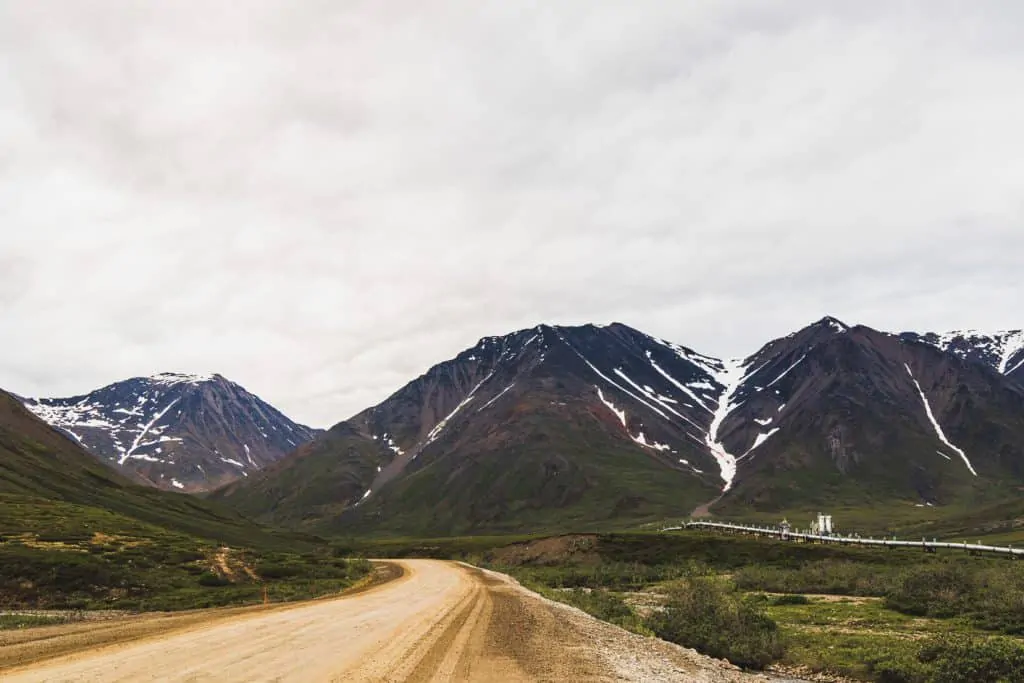
Atigun Pass (Mile Marker 244)
When we drove the Dalton Highway in our truck camper by far our favorite stretch of road began with Atigun Pass.
The pass itself is not incredibly high in elevation. However, the road has a steep grade and several switchbacks that made it challenging in our truck camper.
Even in the middle of summer, you are likely to find vast swaths of snow cover on the ground. It’s worth a stop to stretch your legs and take in the view in each direction.
As you begin your descent from Atigun Pass you enter Happy Valley and the North Slope.
This is perhaps the most beautiful stretch of the Dalton Highway and one you will certainly never forget.
Deadhorse Camp (Mile Marker 412)
Deadhorse Camp is a place of interest because you will actually pass it as you drive the Dalton Highway into Deadhorse.
The best tour to the Arctic Ocean originates at Deadhorse Camp.
And even if you don’t take a tour with them, you can stop and grab a warm meal and some information about the area.
Note: The camp itself is not the end of the Dalton Highway.
Deadhorse (Mile Marker 415)
The town of Deadhorse is at the terminus of the Dalton Highway, a full 500 miles from Fairbanks, Alaska.
Calling it a town is a stretch.
There are technically no permanent residents. The town’s only inhabitants are oil field workers who fly in and out every few weeks in shifts.
It is a highly industrial town and you are definitely not going to fit in with your RV.
Official Deadhorse Sign
The official Deadhorse Sign is located outside of the Brooks Range Supply store in the center of town. It is not a secret.
However, finding the general store can be a little difficult as no buildings in Deadhorse stand out as remarkable in any way.
Most of the time the dirt roads are a mixture of mud and ice/snow and just getting around town to find the sign is an adventure in itself.
But don’t come all the way to Deadhorse and pass up on the photo opportunity!
Things To Do In Deadhorse, Alaska
To be honest, there is not much to do in Deadhorse, Alaska. In fact, most people who drive the Dalton Highway in an RV only do so to visit the Arctic Ocean.
That was our sole motivation. In our journey to drive from Alaska to Argentina, we wanted to go from the very top of the world to the very bottom of the world.
As such, we knew that we had to visit the Arctic Ocean.
However, you are more than welcome to spend as much time as you like exploring the region.
After all, it was one heck of drive up the Dalton Highway in your RV to get there!
If you stay you will find great camping and the opportunity to see incredible wildlife you might not find in other places in your journey.
Visit the Arctic Ocean in Prudhoe Bay
Deadhorse is the terminus of the Dalton Highway. However, the town does not sit directly on the Arctic Ocean.
The last ten or so miles are restricted to the public as oil lease land and only accessible by official tour.

If you were committed enough to drive the Dalton Highway in an RV then you need to plan to book a tour with one of two tour companies in Deadhorse that can take you the extra miles to the Arctic Ocean.
BEST OPTION : Deadhorse Camp .
Cost : $69 per person
Website : https://www.deadhorsecamp.com/
You must book at least 24 hours in advance (book in Fairbanks before you journey north!). This is the most direct, no-frills tour that takes you the last 20-30 minutes north through oil country to the banks of the Arctic Ocean.
You’ll hear about the history of the region and perhaps see a variety of animals as you make your way to/from Prudhoe Bay.
ALTERNATIVE OPTION : Northern Alaska Tour Company .
Cost : Expensive (over $1,000).
Website : https://www.northernalaska.com/
This is a multi-day, all-inclusive tour that isn’t quite suitable if you’re driving the Dalton Highway in an RV.
However, if you start up the Dalton Highway and decide that it is too rough, this may be a good option as they will handle your transportation, accommodation and meals.
Visiting The Arctic Ocean
When visiting the Arctic Ocean your tour guide will likely offer you the opportunity to dip your feet (or whole body) in the ocean.
If they don’t offer, at least they will not frown upon your insistence!
We opted to take a dip in the ocean. The water was so cold there were still chunks of ice floating in it!
And the wind was ripping at over 40 miles per hour. But it was definitely worth the experience.
In fact, due to a funny situation we “double-dipped” in the Arctic Ocean.
But do make sure that whether you plan to swim in the Arctic Ocean or not you have adequate warm weather clothing.
Our visit in July was no walk in the park. So visiting at any other point in the year is likely to be even harsher.
RV Camping In Deadhorse
There are plenty of places to RV camp just outside Deadhorse. Formally you can likely arrange camping at Deadhorse Camp.
They offer full hotel amenities (at a premium) that include a room and meals throughout the day.
But if you have not already figured out how appealing and accessible it is to boondock in Alaska, let your boondocking experience begin in Deadhorse.

Our favorite place was in a gravel parking lot along the Sagavanirktok River a short distance from Deadhorse Camp (GPS 70.19530, -148.42683).
There is excellent cellular service (AT&T) and a great view of the river from this spot.
You really don’t have any other options closer to the center of the town.
But if you prefer more privacy (and the quiet that comes in not having the airport nearby) then you can always pull over at several pull-offs just outside of town.
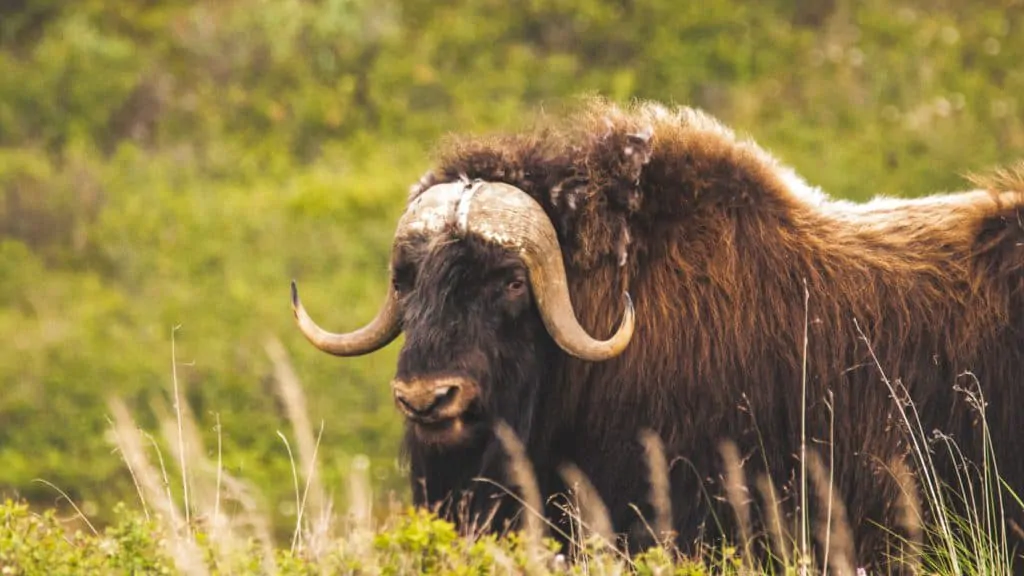
View Wildlife In Deadhorse, Alaska
The North Slope of Alaska is rich in wildlife. Depending on the timing of your visit, you can see any number of over 200 species of birds in and around Deadhorse.
If you are fortunate you will see some other more rare species of animals including the arctic fox, ground squirrels, grizzly bears, musk oxen and caribou.
Of course, if you are brave enough to drive the Dalton Highway in an RV during the winter months you might also see polar bears that frequent the region.
While we did not view much wildlife on our way into Deadhorse we did see hundreds of caribou and a handful of musk oxen on our drive back to Fairbanks.
Driving Back to Fairbanks
Once you drive the Dalton Highway in an RV from Fairbanks to Deadhorse, the scenery back to civilization can be just as amazing, if not entirely different.
Sometimes our fascination with the destination of Deadhorse or the Arctic Ocean will skew our view of the journey.
It’s possible to find yourself in a rush to arrive in Deadhorse and you might overlook some of the other views or stops along the way.
Before you leave Deadhorse be sure to account for any fuel you might need to get you to Coldfoot.
Unless you are able to make the entire 499-mile drive back to Fairbanks on one tank of fuel (or with spare jerry cans) it is a good idea to at least add a little fuel in Deadhorse and then top off in Coldfoot.
The fuel will be more expensive in Deadhorse, of course. But it is much better to ensure your safety on the Dalton Highway and avoid running out of fuel on your return to Fairbanks!
We had a tire blowout on our return trip. So we did not spend much time enjoying the drive back to Fairbanks.
Had we been more prepared with a second full-size spare tire we might have taken our time driving the Dalton Highway in our truck camper.
But if you do have the extra time to journey back toward Fairbanks, consider a couple of other stops along the way:
Wiseman (Mile Marker 226 from Deadhorse)
Wiseman is an old gold mining town that has long since seen it’s glory days pass. There are still a handful of permanent residents in the quirky town.
And as it is only a short side trip from the Dalton Highway it might be worth a visit on your way back to Fairbanks.

Yukon River Camp (Mile Marker 359 from Deadhorse)
The Yukon River Camp is typically one of the first stops as your drive the Dalton Highway from Fairbanks to Deadhorse. It is only 56 miles into the drive north.
But if you pass it by on your way to Deadhorse then it’s worth a stop on your way back to Fairbanks as there is a nice view of the Yukon River and information you can gather from the BLM station.
Any View That Suits Your Taste
Despite our rush to return to Fairbanks in one piece we found ourselves stopping in many places simply to take in the view.
Because the sun never set during our summer journey driving along the Dalton Highway we had the opportunity to see colors and contours in the sky that were quite surreal.

There is very little traffic on the Dalton Highway, particularly once you reach the North Slope.
So there are plenty of gorgeous places to stop on the northern side of Atigun Pass to enjoy the solitude and stillness of the Alaskan tundra.
Enjoy The Drive
Driving the Dalton Highway in an RV is incredibly rewarding! From the wildlife, you will see to the spectacular, desolate landscapes the Dalton Highway is worth the drive.
Of course, be sure you know what you are getting into before you go.
Plan your drive accordingly and give yourself plenty of time to cover the 1,000-mile round trip drive from Fairbanks to Deadhorse.
But with proper planning and consideration for your safety and that of other travelers, you are sure to place this drive at the top of your list of most beautiful and rewarding drives in North America!
NEXT STOP: 14 Of The Best Things To Do In Seward Alaska

About Author

Christopher Harvey
Christopher Harvey is the co-founder and main copywriter for Called To Wander. His passion is to create content that engages and informs readers and helps them to pursue the Abundant Life on the Road. Aside from writing, he also edits videos for the YouTube channel. He has freelanced for a variety of publications and consults with different brands on SEO and content strategy.
See author's posts
The Dalton Highway Road Trip
Updated October 202 3, One Week in Alaska: The Dalton Highway Road Trip was originally written in July 2017
I’ve now made the journey along the Dalton Highway twice and can still say it’s one of the wildest road trip adventures Alaska has to offer! Starting from Fairbanks and quickly whisking off into the Arctic Circle, and on to the end of the road in Deadhorse, this is Alaska way off the beaten path.
Before you set off on your Dalton Highway adventure, check the Alaska DOT’s 511 for construction updates road condition information. Another trusty source of information is the Alaska Milepost , I highly recommend purchasing one before your Alaska road trip. Cheers to adventuring the last frontier!
Need Travel Insurance and Evacuation Services for Alaska?
Start shopping for travel insurance plans over at IATI Insurance . Readers of the Adventures of Nicole get a 5% discount off your plan.
The Adventures of Nicole partners with Global Rescue to offer the world’s leading medical evacuation and security advisory services. To travel with peace of mind, shop evacuation coverage at Global Rescue .

Way Off The Beaten Path: The Dalton Highway Road Trip
This is an itinerary for the super adventurous. Not your ordinary road trip and not for the faint of heart. The Dalton Highway road trip will take you from interior Alaska to the top of the continent. Download the free BLM Dalton Highway Roadtrip Guide here .
Fly Into/Out Of Fairbanks With Skyscanner
Important Things To Note On This Trip
The Dalton Highway is extremely remote and is in fact the longest stretch of service-less road in the whole of North America. North of Coldfoot all the way to Deadhorse there are zero services, zip, nada- not a gas station, no stores, no restaurants, nothing. You need to be prepared.
Bring enough food, bring a car repair kit, camping equipment, and enough water (or a way to filter it). Buy anything you may need for the trip before you leave Fairbanks.
I 100% recommend the Garmin Inreach Explorer + for this trip since you will be able to send messages via satellite, has GPS and has an SOS beacon.
Dalton Highway Road Trip Advice: Remember that the Dalton is a haul road designed for trucks bringing supplies up to the oilfields, therefore, they do have right of way. Do not park on the road. When going past a vehicle coming toward you always slow down, this is a dirt road and you will be flinging rocks and no one wants to replace their windshield more often than they have to.
Always drive with your headlights on at all times. The speed limit is 50 MPH. If stopping along the highway for any reason be at least 10 feet off the side of the road. Make sure you are allowed by your rental company to take the vehicle up the Dalton- many do not allow it. A 4X4 is definitely recommended.
Sleeping: You can camp pretty much anywhere along the highway, just make sure you are pulled off well away from the road and camp set up away from the road as well. Do not camp at pump station access points. There are a handful of designated camps along the way.
There Is Almost No Cellphone Service Or Public Internet Outside Fairbanks and Deadhorse.
When To go: May through September is the recommended time to visit on a Dalton Highway road trip, with June, July, and August being the warmest. It’s not recommended to travel the highway between November and April, temperatures can get extremely cold and with services so few and far between dying out there is a reality.
Note: There are only three gas stations along the Dalton and gas is expensive. It is highly advisable to strap a couple of gas cans (can easily be bought in Fairbanks) to your car.
- Yukon River crossing at mile 56 and only open mid-May to mid-September.
- Cold foot at mile 175 at the Sourdough Gas Station.
- Deadhorse around mile 414. Deadhorse has three gas stations.
Start planning here: The ultimate Alaska travel guide
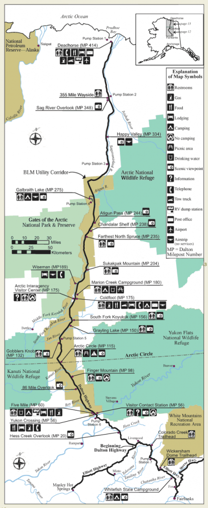
Day 0: Arrive in Fairbanks
Pick up rental car and supplies. Many flights from outside Alaska that go to Fairbanks arrive between 8 PM and 2 AM. You may need to wake up the next morning and grab supplies if you arrive in the middle of the night.
Where To Stay In Fairbanks
Billie’s Backpacker Hostel | Booking.com |
Pike’s Waterfront Lodge | Booking.com | Hotels.com |
Sophie Station Suites | Booking.com | Hotels.com |
Plan your visit: The Fairbank travel guide
Day 1: Head North! Hess Creek, Pump Station #6, Yukon River, Yukon Flats National Reserve View Point, Finger Mountain Trail, Arctic Circle
Find your way to Fox and get on the Elliot Highway to Livengood, just past Livengood is where the Dalton Highway officially begins. The drive today will take you nearly 200 miles from Fairbanks.
Great stops will include: Hess Creek to take in some great views as you begin your journey, Pump Station #6 to see the Alaska pipeline (you’ll have several opportunities to view it along the way), Yukon River is a good place to stop off as it stretches almost 2,000 miles from Canada to the Bering Sea and make sure to check out how the pipeline is suspended above the river.
There is a restaurant here along the Yukon River. At mile 86 there is a mining road that heads west off the Dalton, follow it to see amazing views into the Yukon Flats National Reserve.
Mile 98 offers a pullout for Finger Mountain with a short 1/2 mile trail.
At mile 115 you’ve reached the Arctic Circle! Of course, make sure to get your tourist photos with the sign. There are camping spots available up the hill from the picnic area.

Day 2: Mile 132 Brooks Range viewpoint, Pump Station #5, Grayling Lake, Coldfoot. Camp at Marion Creek
Stop at Mile 132 pullout for grand views of the Brooks Range. Continue north to Pump Station #5- this a unique station as it is a pressure relief station from the oil descending down from the Brooks Range.
Stop for Grayling Lake and keep an eye out for moose, as they like to come here for a drink. Coldfoot is your last taste of civilization, with campsites, an inn, post office, gas station, restaurant, tire service, and even a visitor center.
Plan to camp here or just a few more miles north at Marion Creek with 27 sites available for a fee between Memorial Day and Labor Day. Near Coldfoot, there is a 2 mile hike to a waterfall.
You can opt to hike into Gates of the Arctic National Park from just north of the Coldfoot area as the Dalton Highway sits only 5 miles from the park boundaries.
There is no fee to enter the park, but the park is very remote. Stop by the visitor center in Coldfoot for more information. (Can opt to take an extra day to backpack into the park as well).
Traveling Alaska on the cheap? Check out my budget Alaska travel guide

Day 3: Wiseman, Mile 203 Mt. Sukakpak Viewpoint, Atigun Pass, Pump Station #4, Galbraith Lake
Wiseman is an old mining town 3 miles west of the Dalton Highway. At mile 203 pullout you can stop for views of Sukakpak Mountain.
Further north, Atigun Pass is a great area for trying to spot Dall sheep, is the highest point on the Dalton Highway, and is the continental divide. Pump Station #4 is the highest pump station on the pipeline.
Plan to camp at Galbraith Lake as there are camping sites with an outhouse about 2.5 miles off-road near an airstrip.
You can hike into Arctic National Wildlife Reserve from here to Atigun Gorge, Atigun Lake, and the Brooks Range. (This is another spot you could opt for more time to explore more of the park).
Plan your own day hike into ANWR on your Dalton Highway adventure

Day 4: Pump Station #3, Mile 348 (short trail), Pump Station #2, Mile 383, arrive in Deadhorse
Mile 348 has a short trail with signs about the area and chances to spot the Peregrine Falcon. Mile 383 is a great area to try to spot caribou with a backdrop of beautiful iron-rich cliffs.
Arrive in Deadhorse- celebrate! You’ve made it about as north as you can get on the road system in the entire United States, but you’re only about halfway done with your Dalton Highway road trip.
Starting from Anchorage ? Add on an extra few days for the Anchorage to Fairbanks road trip

Day 5: Join a tour (can be arranged through a hotel) to the Arctic Ocean
The roads between Deadhorse and the Arctic Ocean are privately owned and restricted making the only way to visit the Arctic Ocean by tour only. If you’ve made it this far you may as well go all the way, right?
NOTE: Days 5-6 (after the visit to the Arctic Ocean) can be used as you see fit to accommodate more time for sightseeing, etc….
Can be used to allot for extra hiking around Gates of the Arctic, another option could be to split the long drive back to Fairbanks. You decide.

Day 7: Drive back to Fairbanks- be prepared, it’s a 13 hour drive. Fly home
You can always opt to use the days prior to your journey back to Fairbanks to break up the long trip and spend your final day exploring Fairbanks to end your Dalton Highway road trip.
*You’ll probably notice that this trip includes excess days. This gives more time to explore areas of your choosing or extra time just in case you have a problem. This trip can be done roundtrip in 3 days, although it doesn’t yield you much time for stopping and exploring. This trip could also be extended over a much longer period for those looking to hike and backpack.
Looking for more ideas? Check out the 34 best things to do in Alaska

Want To Travel Alaska? Are You On A Budget?
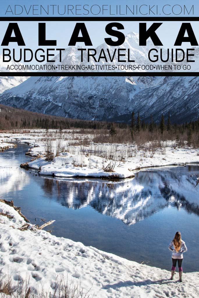
Have Any Questions About This Dalton Highway Road Trip?
Ask your Dalton Highway questions in the comments section below.
Want More Ideas For One Week In Alaska Itineraries?
Check out the following posts in the ‘One Week In Alaska’ series:
- Hit The Highlights- Anchorage to Fairbanks
- North To The Future: The Dalton Highway
- Glaciers, Fjords, & South Central Alaska
- The Big Loop: Anchorage to Fairbanks & Back
- The Denali Highway Road Trip
- The Best of Wrangell St. Elias and Prince William Sound
More Posts from Alaska:

Twin Peaks & Eklutna Lake

The Best Places To See The Northern Lights in Alaska

9 Tips For Viewing The Aurora

Girdwood Travel Guide + 5 Things To Do In Girdwood, Alaska

Anchorage To Fairbanks Road Trip: One Week In Alaska

The Big Loop Alaska Road Trip

2 Day Anchorage Itinerary

Hiking The Mint-Bomber Traverse

Travel Alaska On A Budget

How To Visit Gates of the Arctic National Park

A Guide To The Denali Highway

Visit Spencer Glacier On The Whistle Stop Train

Visiting Byron Glacier

How To Get To Mendenhall Ice Caves

16 Best Day Hikes Near Anchorage, Alaska

What to Pack for Alaska, Written by a Local

Anchorage’s Best Hotels: Where to Stay in Anchorage

Biking to Knik Glacier in the Winter

A Day Hike Into ANWR

Fairbanks Travel Guide + 13 Things To Do In Fairbanks

Shrine of St. Therese In Juneau, Alaska

How Much Does It Cost To Travel In Alaska?

The Best Way To Explore Kenai Fjords National Park: Major Marine Tours

The Ultimate Alaska Highway Guide: Driving the Alcan between Canada & Alaska

Wrangell St. Elias Road Trip, Alaska

A Quick Guide To Hope, Alaska

How To Get A Denali Road Lottery Permit

The Rabbit Lakes Hike In Anchorage, Alaska

Kayaker’s Cove: My Favorite Escape From Seward

Homer Travel Guide + 14 Things To Do In Homer

34 Best Things To Do In Alaska

Williwaw Lakes Hike In Anchorage, Alaska

The Ultimate Alaska Travel Guide

Kenai Peninsula Road Trip
Anchorage travel guide + 20 things to do in anchorage.

Juneau Travel Guide + 19 Things To Do In Juneau

The Best Road Trips In The World

Denali National Park Travel Guide + 14 Things To Do In Denali

10 Reasons to Visit Alaska

Seward Travel Guide + 18 Things To Do In Seward

MacDonald Spit, My Favorite Coastal Alaska Destination

Visiting Virgin Creek Falls In Girdwood, Alaska

Free Things To Do In Anchorage

The Ultimate Alaska Road Trip Itinerary

K’esugi Ridge Hike in Denali State Park, Alaska

Snowbird-Bomber Hike in Hatcher Pass

The Reed Lakes Hike In Hatcher Pass, Alaska
10 day alaska itinerary.

Eagle & Symphony Lakes Hike, Alaska

The Perfect Coastal Alaskan Winter Getaway: Between Beaches

Kenai Fjords National Park Travel Guide

Best Hostels in Anchorage, Alaska

Free places to Ski & Snowboard Near Anchorage

10 Off The Beaten Path Destinations For 2021

Arrigetch Peaks Expedition: Gates of the Arctic National Park, Alaska

The Surreality of the Underbelly: The Mendenhall Cave, Inside a Glacier

The Road To Kantishna

Eating My Way Across The Alaska State Fair
2 thoughts on “the dalton highway road trip”.
Would love to cycle up the Haul road one day!
It would be quite the adventure!
Leave a Comment Cancel Reply
Your email address will not be published. Required fields are marked *
Notify me of followup comments via e-mail. You can also subscribe without commenting.
This site uses Akismet to reduce spam. Learn how your comment data is processed .

- Denali National Park
- More Destinations...
- Dawson Creek
- Dawson City
- Fort Nelson
- Fort St John
- Hudson’s Hope
- Watson Lake
- Tumbler Ridge
- Alaska Highway
- Klondike Highway
- Top of the World Highway
- Cassiar Highway
- Haines Highway
- Dempster Highway
- John Hart Highway
- Yellowhead Highway
- Parks Highway
- Seward Highway
- Sterling Highway
- Glenn Highway
- Richardson Highway
- Tok Cut-off
- Denali Highway
Dalton Highway

Glacier Viewing

Flightseeing

Wildlife Viewing

Find the perfect activity.
Search through locations, accommodations and more.
- Vacation Planning
- Guides & Maps
Destinations
- Things To Do
The Dalton Highway in Alaska is a 415 mile/667 km long highway that connects the Interior of Alaska to the far North. The Dalton Road begins at mile 73 on the Elliott Highway (78 miles north of Fairbanks ) and ends at the town of Deadhorse, a few miles from Prudhoe Bay, site of North America’s largest oil discovery. The Dalton Highway is the only road in Alaska that crosses the Arctic Circle and reaches the north coast of Alaska on the Arctic Ocean. At mile 244 of the highway, you will cross the Atigun Pass at 4737 Ft high.
Still known locally as the ‘Haul Road’ it can be a very challenging highway to travel. The primary users of the Dalton highway are the oil companies, which means most of the vehicles on the highway are large trucks. These truckers are professional drivers but they also tend to take up a lot of room on the narrow road (28 ft/8.5 meter wide). The surface is gravel and can be quite rough, dusty or slippery depending on the weather. There are long distances between commercial operations and here is where the problem lies. If you have any sort of mechanical difficulties or medical problems it can take hours or even days to get help. The cost of towing vehicles up here can be expensive. Many rental car companies prohibit driving on the Dalton Highway and other gravel roads in the state.

Northern Alaska Tour Company
If you choose to go on your own please contact the Alaska Public Lands Information Center (APLIC) at 101 Dunkel St Fairbanks. 907-459-3730
For Updates on Dalton Highway Road Conditions and Construction, Click Here
Preparations for traveling: you should carry 2 full-size spares, emergency flares, extra gas and windshield wiper fluid, bug repellent, rain gear, first aid kit, emergency food & water and camping gear. Travel with your lights on, slow down when other vehicles are approaching, do not stop on the road.
For a complete list of Things to do in Alaska on your trip north, visit our Things To Do section . For information on places to camp, visit our section on camping in Alaska . To determine when you should plan your trip to Alaska, visit our page on the best time to visit Alaska . Because the Dalton Highway crosses the Arctic Circle, taking travelers further north than any other highway in Alaska, it can make for amazing Northern Lights (Aurora Borealis) viewing from September to April.
Livengood. Junction of Elliott Hwy. and The Dalton Hwy. Turn west to Eureka and Manley Hotsprings.
The Dalton Highway crosses the Yukon River. The 1/2 mile long bridge was built during the winter of 1974-75. Yukon Crossing, telephone, gas, food and accommodation. BLM maintains a visitor contact station staffed with volunteers open daily from 9 to 6 from late may to September.
Sixty-Mile, undeveloped camping area, water, outhouses, food, dump station and lodging.
Finger Mountain Wayside, scenic viewpoint, 1/2 mile interpretive trail to the summit of Finger Mountain.
Arctic Circle scenic viewpoint with interpretive signs, picnic area, outhouses and undeveloped camping area.
Gobbler’s Knob, viewpoint with excellent views of the Brooks Range to the north.
Grayling Lake moose are often found in this nutrient rich aquatic vegetation. Viewpoint and outhouse.
Coldfoot. Visitor Center open daily, 10 a.m. to 10 p.m., from May 25 through September 11. . BLM staff are available to answer questions and provide road condition and wildlife sightings.
Wiseman, drive 3 miles west of the highway to reach Wiseman, an old goldrush town established in 1907. Lodging and airstrip.
Sukakpak Mountain elev. 4,459 ft. Once a limestone deposit, heat and pressure metamorphosed it into marble before it was thrust up during the formation of the Brooks Range. Viewpoint.
The “Last Tree” along the Dalton Hwy.
Chandalar, view of the Dietrich River valley to the south.
Atigun Pass, elev. 4739 ft. As you travel over Atigun Pass, you are going over the Continental Divide. Rivers to the north empty into the Arctic Ocean, while rivers to the south empty into the Bering Sea. North of the Atigun Pass, permafrost grows deeper (over 2,000 feet in the Prudhoe Bay area) and is present almost everywhere. South of the pass, permafrost areas become thinner and less prevalent. Watch for Dall sheep on the mountain sides around Atigun Pass.
Galbraith Lake, this large glacial lake was dammed by a terminal moraine located north of Galbraith Lake. Turn west off the highway just north of Galbraith Lake and travel approximately 3 miles to reach an outhouse and undeveloped camping area. This area offers beautiful views and good hiking opportunities into the Brooks Range.
Toolik Lake, an arctic research station is based on the shores of Toolik Lake.
Happy Valley is the site of a former pipeline construction camp.
Coastal Plain Overlook, enjoy the panoramic view of the coastal plain.
Franklin Bluffs, the iron rich soils on the east bank of the Sagavanirktok River give the bluffs their rich yellow, tan and orange colors.
Deadhorse is the support community for the Prudhoe Bay oilfields. The public road ends at Deadhorse, approximately 7 miles short of the Arctic Ocean. Both hotels in Deadhorse offer tours of the oil fields and Arctic Ocean. Restrooms, telephones, food, lodging, post office, gas, tow truck, RV dump station and airport are all available.
Alaska Travel Tips
Sign up for our 4-part email series to discover critical information for planning your ultimate Alaska vacation!

©Bells Travel Guides. All Rights Reserved
- City and Highway Maps
- Best Time to Visit Alaska
- Mosquitoes in Alaska
- Camping in Alaska
- Which Alaska Cruise Itinerary is Best?
- One Week Itinerary Ideas for Alaska
- Alaska in June

Looking to see bears in Alaska?
Check out these amazing alaska tours., think you know alaska, take the quiz and find out....
Alaska's Firefighters Ignite Belief That We Can Beat Invasive Species!

During the 2020 Isom Creek fire, a firefighting line was built from the Dalton Highway that crossed state lands and entered the Yukon Flats National Wildlife Refuge, ending at the Yukon River. Firefighters' awareness helped prevent the spread of invasive plants during the construction of the firefighting line and when the line was in use. Invasive plant seeds were likely removed during firefighters' gear refurbishment time in-between assignments, by washing, drying and airing out of firefighting gear, and by general daily awareness of the condition of fire boots and clothing.

Near the end of fire suppression operations, Dale Woitas (U.S. Fish and Wildlife Service) and Andrew Allaby (Alaska Department of Natural Resources) worked with the State of Alaska Department of Transportation and fire crews to establish barriers to the firefighting line. Barriers included planting willows as living barriers and placing boulders at the Dalton Highway to deter unauthorized off-road vehicle use on the line after the fire.
The Isom Creek Fire burned 12,149 acres (7,112 acres of State of Alaska managed land, 4,146 acres of U.S. Fish & Wildlife Service managed land, 858 acres of Tribal land and 33 acres of Bureau of Indian Affairs managed land). Yukon Flats National Wildlife Refuge staff are thankful to fire crews for their work to prevent invasive species invasive species An invasive species is any plant or animal that has spread or been introduced into a new area where they are, or could, cause harm to the environment, economy, or human, animal, or plant health. Their unwelcome presence can destroy ecosystems and cost millions of dollars. Learn more about invasive species introduction and thankful to state and federal agencies that worked together to protect the refuge, more than six Native allotments, the Trans-Alaska Pipeline, and the Dalton Highway Corridor.

Featured in the Story
Latest stories.

You are exiting the U.S. Fish and Wildlife Service website
You are being directed to
We do not guarantee that the websites we link to comply with Section 508 (Accessibility Requirements) of the Rehabilitation Act. Links also do not constitute endorsement, recommendation, or favoring by the U.S. Fish and Wildlife Service.
IMAGES
VIDEO
COMMENTS
Yukon River. Northern Alaska Tour Company pioneered Arctic Circle touring on Alaska's Dalton Highway. Today we take pride in being the operator of choice for those traveling in Alaska's Arctic. Our one-day and multi-day excursions, available both during summer and winter, allow the traveler to experience this region in a comprehensive yet ...
Then, enjoy a fully-guided van tour along the Dalton Highway. Alaska's Dalton Highway is the state's lifeline to the Arctic Circle and the Far North Region. Get a taste of the Gates of the Arctic National Park, the Arctic National Wildlife Refuge, the Brooks Range, and Alaska's North Slope! With rustic accommodations in Coldfoot and ...
The Dalton Highway slices through northern Alaska from Livengood, crossing the Arctic Circle to the oil fields of Prudhoe Bay. ... NAT04: Northern Alaska Tour Packages: Dalton Highway Day Tour. Dalton Highway Fly | Drive Day Tour : Rate in US$ per Person : Arctic Circle Fly & Drive Tour from Fairbanks (1:00 PM - Returns at 1:00 AM) $ 499.00:
Day 1. From Fairbanks, hop on the Elliot Highway approximately 70 miles past historic gold mines to Livengood, where you'll pick up the start of the Dalton Highway. It's a far cry from the original gravel access road built during the construction of the Trans-Alaska Pipeline, but you'll still want to take it slow over the remaining gravel ...
The highway—built in 1974 to facilitate the pipeline's construction—is mostly used only by truckers carrying supplies to oilfield workers in Deadhorse. And it's a tough drive: steep and slick in places and muddy in others, with those trucks occasionally flinging rocks and gravel onto your windshield. For this reason, most rental cars ...
Ground tour north from Fairbanks in the personalized comfort of our tour vehicles. Learn the story of Alaska's Arctic both while traveling in the van and at the various stops along the way. View the remarkable Trans Alaska Pipeline. Travel the rugged Dalton Highway made famous by the construction of the Trans Alaska Pipeline.
DAY 1 - Ground tour north in the personalized comfort of our tour vans. Visit the Arctic Circle Trading Post situated in the rural community of Joy, Alaska. Travel the rugged Dalton Highway. Experience the mighty Yukon River. Marvel at the majestic beauty of the northland's most famous waterway and learn of the river's storied past.
DAY 1. Ground tour north on the rugged Dalton Highway. Visit the Arctic Circle Trading Post situated in the rural community of Joy, Alaska. Explore up close the amazing arctic tundra and feel the veins of ice just beneath the surface. Experience the mighty Yukon River. Marvel at the majestic beauty of the northland's most famous waterway and ...
Alaska Route 11, known as James W. Dalton Highway or North Slope Haul Road, runs through the north of Alaska. The Dalton Highway starts 84 miles (134 km) north of Fairbanks, in Livengood, on Elliot Highway. It ends 414 miles (666 km) further north at Deadhorse and the oilfields of Prudhoe Bay, a few miles short of the Arctic Ocean.
The aforementioned Northern Alaska Tour Company also offers private charters up and down the road. Finally, if you're a seasoned backcountry traveler, and have some experience driving (and surviving!) in rough, mountainous country, self-driving may be the option for you. Dalton Highway and the Trans-Alaska Pipeline.
View on Map. 3820 University Ave South. Fairbanks, AK 99709. By Car: Located on the East Ramp of the Fairbanks International Airport. The terminal for Northern Alaska Tour Company can be found at 3820 University Avenue, just beyond the Flight Control Tower. Driving Directions.
Select from a variety of optional tours which include an excursion along the Dalton Highway, into the Brooks Mountain Range, as far north as Atigun Pass (weather permitting); a one-hour dog sledding experience with a local musher, and additional aurora viewing in Wiseman (optional tour prices are not included). DAY 3 - or last day if staying ...
Overview. The Dalton Highway slices through northern Alaska from Livengood to the oil fields of Prudhoe Bay. Built in 1974 as the service road for the Trans-Alaska Pipeline, the highway is not to ...
The Dalton Highway, also called the Haul Road, is one of the northern-most roads in the world. It was originally constructed by Alyeska Pipeline Service Company to support the development of the Trans-Alaska Pipeline and to service the oil fields on Alaska's North Slope. It is now owned and maintained by the State of Alaska and is open to the ...
Depart Fairbanks in the morning and travel north on the Dalton Highway. The Dalton Highway is also known locally as the Haul Road, or perhaps even more famous as the "Ice Road", a trucker supply route to the North Slope oilfields. Stops en route include the trading post at Joy, the Yukon River, and a ceremonial crossing of the Arctic Circle.
Dalton Highway. The Dalton Highway stretches 414 miles across northern Alaska from Livengood (84 miles north of Fairbanks) to Deadhorse and the oilfields of Prudhoe Bay. Built to allow for construction of the trans-Alaska oil pipeline in the 1970s, this mostly gravel highway travels through rolling, forested hills, across the Yukon River and ...
This Northern Lights viewing tour in Fairbanks takes you on a guided van tour along the Dalton Highway to the Arctic Circle. See the Aurora Borealis for real - far from the city lights of Fairbanks. ... The Go Alaska Tours Website (www.goalaskatours.com) uses GeoTrust for its SSL and 128-bit encryption. Quick Navigation. Sunday, 28 April 2024 ...
From this point, it is 415 miles one way to the terminus of the highway in Deadhorse, Alaska. Road Conditions: Road conditions are less than ideal along the Dalton Highway. ... But allowing yourself 2 days to travel up the Dalton Highway, 1 day to take a tour to visit the Arctic Ocean and 2 more days to travel back down the Dalton Highway.
Wiseman is an old mining town 3 miles west of the Dalton Highway. At mile 203 pullout you can stop for views of Sukakpak Mountain. Further north, Atigun Pass is a great area for trying to spot Dall sheep, is the highest point on the Dalton Highway, and is the continental divide. Pump Station #4 is the highest pump station on the pipeline.
The Dalton Highway in Alaska is a 415 mile/667 km long highway that connects the Interior of Alaska to the far North. The Dalton Road begins at mile 73 on the Elliott Highway (78 miles north of Fairbanks) and ends at the town of Deadhorse, a few miles from Prudhoe Bay, site of North America's largest oil discovery.
But for adventure riders, the defining, must-do ride is the 414-mile Dalton Highway, more commonly known as the Haul Road, beginning north of Fairbanks, Alaska, and ending at Prudhoe Bay on the ...
During the 2020 Isom Creek fire, a firefighting line was built from the Dalton Highway that crossed state lands and entered the Yukon Flats National Wildlife Refuge, ending at the Yukon River. Firefighters' awareness helped prevent the spread of invasive plants during the construction of the firefighting line and when the line was in use.