
ITMB PUBLICATIONS
New Products For April - ITMB PUBLICATIONS
Monthly Specials For April - ITMB PUBLICATIONS
ITMB Travel Maps
- Wall maps, travel maps, guide books, globes and more!
- Finishing Options

- Search for:
No products in the cart.
Return to shop
- Personalized Maps
- Best Selling Maps
- Political Maps
- Physical Maps
- Historical Maps
- Africa Maps
- Antarctica Maps
- Australia Maps
- Europe Maps
- North America Maps
- South America Maps
- Country Maps
- International Region & City Maps
- U.S. Region, City, County Maps
- Congressional Maps 2022
- City & County Maps
- Classroom Pull Down Maps
- Topographic Maps
- Foreign Language Maps
- Space, Science, Culture & More
- Map Accessories
- World Raised Relief Maps
- United States Raised Relief Maps
- State Raised Relief Maps
- USGS Region Raised Relief Maps
- National Park Raised Relief Maps
- Other Raised Relief Maps
- Best Selling Combo Maps
- Elementary Classroom Maps
- Middle School Classroom Maps
- High School & College Classroom Maps
- History Maps
- Custom Spring Rollers
- Spring Roller Installation
- NOAA Charts
- U.S. Folding Maps
- Regional Folding Maps
- State Folding Maps
- City Folding Maps
- Continent Folding Maps
- Country Folding Maps
- National Park Maps
- National Forest Maps
- Appalachian Trail Maps
- World Atlases
- U.S. Atlases
- U.S. State Atlases
- Folding Maps
- Professional Driver Atlases
- For Business
- For Decoration
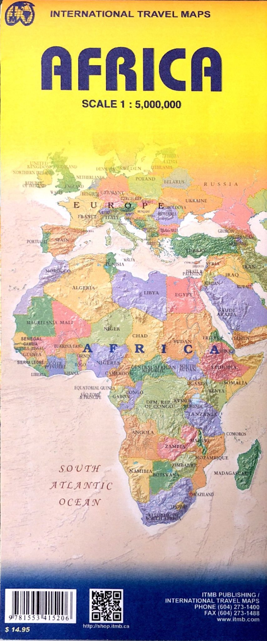
ITMB – Africa – Folding Travel Map
$ 15.95
The durable and convenient ITMB maps will take all the wear and tear your journey can dish out.
Publication : September 2021 || Size : 4.25″ x 9.75″ (Folded)
- Description
- Custom Maps
The continent of Africa is fascinating. Whether on wishes to visit the continent or just learn more about it, a detailed map is vital, and a good map is hard to find! The first edition of our ITM Africa map sold out in less than two years. We have added a considerable amount of data to this edition of the map, particularly in the northwest portion. One has to be careful not to overload a continental map with too much information, or to show roads so prominently as to obscure too much the map, but one also has to have enough information to make the map useful, readable and attractive. We feel that this edition moves in this direction, but it is a work in progress, so more data still needs to be added in the future.
We love technology and enjoy the convenience of GPS, but you can’t plan a trip on a phone screen and navigation doesn’t work where there’s no cell signal. Start your next trip on the right foot with a high-quality folding travel map. Make the most of your next adventure, even if you lose GPS or cell signals. You’ll always be on the correct route with our folding travel maps. Your adventure starts here!
About the Author
ITMB Publishing (International Travel Maps and Books) prepares detailed travel maps and atlases of countries and regions around the world, specializing in Africa, Asia, Canada, the Caribbean, Europe, the Middle East, and Latin America. As a publisher, ITMB has released more than 425 titles to date and is adding about 30 new titles each year.
Back-Orders & Out of Stock Items
If the item is currently out of stock it will ship as soon as we can get it. This will be shown in the “Normally Ships in” section above. If the item is on backorder you will recieve an email with updates as we recieve them. Our goal is to get your products to you a quickly as possible!
We offer free returns within 30 days for this product. Contact us within 30 days of receiving your product to receive a return authorization number, which you can write on the box and ship back to us. We will issue your return within three days of receiving the product back. **We do not refund the initial shipping charges and you’re responsible for shipping charges to get the product back to us unless we made a mistake in the order.
- Continent Maps
- United States Maps
- Kids Section
- International Maps
- States Maps
- USGS Regional Maps
- Map Pins, Markers & Stickers
- Mounting Hardware
- Need Help? 704-332-5557
Username or email address *
Password *
Remember me Log in
Lost your password?

- CATALOG/SAMPLES
- HOW TO ORDER

Excursion to our past, present and future
ITMB Publishing Ltd., which is just a formal way of saying International Travel Maps and Books, began as partnership between a frustrated Australian cartographer who loved South America (and railed against the inadequacies of maps of that continent) and a Canadian map distributor and retailer who was equally frustrated by the lack of maps related to South America for his customers. That was in 1983, when only cartographic houses in Europe published international travel maps and then only of areas of significant travel interest to Europeans. Thus, one could find excellent maps of Malta or the Costa Brava, but exceptionally little related to Africa or Asia, and virtually nothing of any part of Central or South America .
The two bright sparks who spent two weeks together in Vancouver planning to map an entire continent had no money, no resources, and no thought as to how (or by whom) these wonderful maps of South America would be published. It was assumed that established map publishers would love to have maps of the southern portion of the western hemisphere. The cartographer, Kevin Healey, and the businessman, Jack Joyce, blissfully unaware that what they were planning to do was deemed to be completely and utterly mad, if not impossible, self-published, with a very supportive British publisher, Bradt Publications, a two-sheet map of South America at 1:5,000,000 scale in 1984, using artwork previously published by Kevin privately in 1980. Sales provided funds to keep Kevin in peanut butter until the next title (North West South America at 1:4,000,000) was ready to be shown to European map publishers in 1986. Jack duly presented it to every cartographic publishing house in Europe in the hopes that one of them would 'snap it up'. The memory of the howls of derision and contempt expressed by these European firms at the effrontery of two 'colonials' thinking they could make maps, remains fresh forty years later.
Most publishers refused even to look at the artwork; one even turned his back on Jack while they were talking and blithely started a conversation with a colleague. Only one publisher, Rudiger Bosse of Ravenstein Verlag, was encouraging, although he too gave five very good and logical reasons explaining why ITM's attempt was foredoomed to fail, which he was big enough to retract five years later!
Forty years later, ITMB is one of the largest and most successful map publishing houses in the world, with more than 600 maps in print of continents, regions, countries parts of countries, and cities around the world, many of which are two separate maps sharing one sheet of paper. New titles are always under development, and an average of one new map is being published each week, week after week, month after month. This is a production rate unmatched by any other mapping house in the world.
Kevin was a brilliantly artistic cartographer whose titles transcended technical excellence and became sort of works of art. To this day, no one has approached his level of quality or detail - and I'm not just saying that as his publisher. His South America map was finally retired in 2005, after a quarter century in print, and still forms the base of the new digital version of his map, which continues to be the best selling map of the continent in print. His version of Panama is still noted in the Lonely Planet guide book. His map of Canada's west coast Haida Gwaii/Queen Charlotte Islands revolutionized recreational mapping in Canada. His artwork has all been copied into digital format artwork, and updated, but his work is so accurate that, to this day, no one has surpassed his quality.
The key to ITMB's success was the release of our first country map in 1990, Costa Rica, just as tourism to that country started to explode. Other beautiful creations followed, flowing from Kevin's fertile vision - Belize , Baja California , Mexico , BC's Haida Gwaii/Queen Charlotte Islands, Yucatan Peninsula , Ecuador , Galapagos Islands, Guatemala , Panama , Venezuela . Suddenly, ITMB was a recognized name and we found ourselves filling a niche that everyone else had ignored. ITMB then began developing recreation maps for British Columbia at the request of the Outdoor Recreation Council, and buying artwork from other publishers to expand our range to include Japan, Australia, New Zealand, Jamaica and other travel destinations.
Perhaps because neither partner was sophisticated in the perceived realities of how maps were supposed to be prepared (the "It was good enough for my grandfather" mentality dominated map publishing at that time), or because they 'lucked' upon a business structure that made sense, ITMB started gathering a coterie of excellent independent cartographers and joint venture partners who shared ITMB's growing conviction that long-term success would come from a variety of firms sharing production costs and marketing under a common cover, regardless of ownership. Thus, ITMB worked out a joint venture agreement with the Government of Vietnam in 1992 that created a definitive travel map of that country, to be followed by several other maps, such as detailed regional maps of central and northeastern VN, beautiful maps of Hanoi, Hue, and Ho Chi Minh City/Saigon and the Mekong Delta, and first-ever maps of Laos and Cambodia that have helped open the doors of tourism for the entire region. We now have our own production facility in Hanoi .
Perhaps the story of ITMB's growth is getting ahead of itself. The actual reality is that ITMB struggled for years to produce and market maps of countries and cities that relatively few people visit. It took eleven years for ITMB to show a profit. Maps of Central and South American travel destinations have, after all, a limited and finite appeal. Also, they sell reasonably well from September to May, but sales are slow during the rest of the year. Kevin and Jack realized pretty quickly that ITMB needed something more than excellent Latino titles to bring in revenue during the 'off' season to stave off starvation.
In 1989, Bob Peart of British Columbia 's Outdoor Recreation Council approached Jack with the idea of preparing maps of selected areas of recreational significance in BC for publishing. The ORC would pay the development costs and own the films, but ITMB would publish the maps and market them. Jack arranged with two cartographers, David Sami and Gyan Verma, who prepared the artwork for the recreational maps, using material provided by the ORC and the provincial government. A dozen titles were produced before the ORC changed direction and stopped mapping, but by then recreational mapping was well-established. ITMB now publishes its own series of BC recreational titles, with such interesting titles as the Bowron Lakes Canoe Route, Algonquin Park, BC's West Coast Trail, and Whistler. We now also publish excellent recreational maps of American destinations and a growing series of famous mountains in Europe and Asia (Everest, Mont Blanc, Fuji, Rocky Mountains, Andes etc.)
Another Canadian cartographer, Eric Leinberger, joined us in 1996, producing our own artwork for maps of Australia and New Zealand and a special series of maps interpreting Canada to map users - Western and Eastern Canada, Alberta/BC, Prairie Provinces , Northwest Territories , and Atlantic Canada. These titles have now largely been replaced by more refined provincial/territorial maps, but Eric showed the way. We now have published maps of each province and territory in Canada (13), and several maps using Canada Map Office artwork, somewhat modified by ourselves to add travel-related information, and we are the third largest publisher of Canadian material in the world (after CMO and GMJ).
In 1999, Andrew Duggan, of Toronto , joined us to focus on a new series - Cities of the World. His first two titles, Montevideo, Uruguay, and Buenos Aries, Argentina, led to Santiago de Chile, Istanbul, Mexico City, Rio de Janeiro, Tokyo, and a series of American city titles. ITMB is now the world's leading publisher of international world class cities, with more than 100 titles in print. The era of great city maps is probably passing, as technology enables individuals to find their way around urban areas using GPS and Google, but there will always be a steady demand for paper maps of major travel destinations. Volker Schniepp undertook creating the first-ever digital map of any part of Latin America (Uruguay), and followed it with a project to map Peru that took him seven years to complete, as resource material was extremely limited.
Our joint venture with the Government of Vietnam has blossomed into an independent production facility in Hanoi managed by ITMB. Using half a dozen groups of dedicated cartographers, marvelous maps of exotic travel destinations are emerging regularly. We are now using GIS technology quite a bit in creating new maps. We also bring promising young cartographers to Vancouver for extended training.
Stephen Stringall and Gary Sawyer joined us in 1993 to prepare a map of Alaska, which, by the way, has anchored our growing American series of titles ever since. Initially, we ignored the USA for the obvious reason that local publishers were serving the public reasonably well with state and city maps. That all changed in 2007 as the Great Recession swept across the USA and decimated the mapping industry, among many others. Every single publisher of maps in the USA went bankrupt within months, with the exception of National Geographic and a few recreational regional publishers. Suddenly, in the course of a few months, an entire publishing industry shut down. Demand was still present, but supply rapidly dried up. ITMB had developed its marking in the USA by using such firms as Map Link, Treaty Oak, Mapsco, and AMC. Almost overnight, 25 years's worth of marketing expertise disappeared as each of these firms shut down. ITMB responded by devoting all its energy into creating a new series of maps covering major American regions, states, and cities, and is now a major publisher of maps of all of North America, which includes Mexico and Central America.
Stephen also agreed to concentrate on producing high-quality artwork for African countries. Over the next ten years, he created more than two dozen country maps of this almost unmapped continent. His artwork has largely been replaced by more modern digital-format material, now that satellite imagery is available, but the world owes him credit for spending years attempting to map a continent single-handedly. ITMB has dedicated itself to the challenge of mapping Africa comprehensively, and virtually every country of this vast continent has been completed to date, including a brilliant continental map and a series of regional maps. ITMB is the world's number one mapper of Africa. Michaela Fritz, who produced ITMB's award-winning Rwanda/Burundi map, developed the title as a cartographic student in Germany and refined it for publishing by ITMB upon graduation. Torsten Claussen's map of Sierra Leone , also initially prepared as a graduating thesis, was re-worked by him into its current published format after graduating. Kevin Philip, of Zimbabwe, developed maps for ITMB of Swaziland, Bulawayo, and Harare. Gizella Bassa, of Hungary, developed an excellent map of Zimbabwe. The 'dark' continent of Africa is, as a result of the brilliance of these cartographers, emerging as travel destinations for the world to explore.
GIS technology and satellite imagery has revolutionized map production, but the work of the cartographer remains as vital as ever. If GPS mapping is ever to get out of the simplistic style we see in in-car navigation, computer-trained cartographers have a lifetime of work ahead. Also, many parts of the world remain poorly mapped; Africa in particular needs continuous attention, but much work remains to be done in the Caribbean, the South Pacific, and cities in Asia. ITMB still has an enormous amount of work ahead. Although the US and Canada had been well-mapped by others, touristically, most cartographic firms have shut down and new maps need to be prepared for visitors to enjoy. As well, while changing market needs are reducing the need for Rand McNally-type street maps, need for regional, state, and recreational maps of such areas as the USA Pacific Coast, the USA rail network, and the USA Southwest continues to be strong.
ITMB has now completed 40 years in business as a publishing house and retail venture, and has evolved from a couple of incompetents naively deciding to map an entire continent to a professional cartographic publishing house mapping the world, one little piece at a time. We use the latest technology, do our level best to ensure that ITMB maps contain the most accurate and up to date information that can be published, and assertively stake out the entire world for mapping and marketing. ITMB now has 60 titles on Latin America, more than any other publisher, 101 world class city maps, 35 titles on Asia, 45 on Africa, and another 75 on Canada , the USA , and Mexico , with more new and exciting titles being released each week. That's the good news; now, we need to move on to the human toll.
The most painful aspect of ITMB has been left for the last. In 1994, having just completed a beautiful map of Venezuela , Kevin Healey died of heart failure at age 48. Not only was a brilliant cartographic talent cut off in his prime, he was the soul of ITMB and the mentor to the other cartographers. Furthermore, his intimate knowledge of South America and his focused concentration on productivity were legendary. As a business partner, his contribution was crucial to ITMB's success. The relationship joining Kevin and Jack transcended normal business conduct and his death had a profound affect on the structure of the company. Imagine, if you would, Gilbert carrying on without Sullivan, or Rolls without Royce (or, if you prefer, Abbott without Costello). The magic guiding ITMB was the unswerving conviction that what the team was producing was beautiful, accurate, and necessary. Whether or not it made money was not considered. For ten years, the firm's fundamental goal had been to map South America; all else was seen as a means to that end. Suddenly, the one person who could realize that vision was gone. It was devastating on a personal and on a corporate level. It was left to Jack to restructure ITMB and carry on, somewhat sadly, the formidable challenge of mapping the world, with no one in place to fill the master's cartographic shoes.
A new master designer was found, expectedly, in Ha Noi. Thanks to Jack's interest in promoting travel to Vietnam to overcome the trauma caused by the war years in that country and it's effect on America, Jack visited that lovely but isolated (at that time) country in 1992 as a guest of the Vietnamese government, to advise them how to open the country to increased tourism, which at that time was about 2,000 individuals per year. His assigned minder, Do Ngoc Lan, a lovely and talented cartographer and printer working in the government's cartographic printing office, proved to be irresistible. They married in Hanoi in 1995 after a long and difficult courtship and many trips to VN by Jack. She arrived in Vancouver in 1996 as a new Canadian immigrant to find that chaos reigned supreme in ITMB. Over the next decade, she gradually tamed the cartographic monster and developed production standards and digital equipment that now operate smoothly all over the world, whipping electronic files from Russia to Vancouver to Toronto to Vietnam and cowing printers from China to England to Korea with her superb grasp of print technology. Under her iron fisted softness, ITMB has matured and grown into a cartographic house of significance, producing an average of 75 new releases annually. During her 28 year tenure (to date), ITMB has grown from 40 maps to 610.
ITMB is the most international cartographic house anywhere, with production and marketing arrangements operating in parts of the world that most of us don't even realize exist. Much of ITMB's success lies with Lan, with her ability to grasp the essence of a concept and develop it with teams of colleagues who hardly know what she is talking about into a finished piece of artwork that becomes a published map before anyone realizes what is happening. Lan and Kevin were on opposite mapping teams during the American/Vietnam War. They never met. How remarkable that two such strong-willed individuals seized a vision of mapping an entire world, an impossible concept exceeding anyone's grasp, and gradually realized it over a lifetime's dedication to interpreting the world using rapidly-changing technology. We aren't finished yet. GIS technology is revolutionizing how maps are made and improving accuracy precision, and traditional cartography is evolving as a result.
Now, we are in the process of transferring responsibility for mapping the world to the next generation. Lan is showing no signs of wanting to slow down, but Jack has accepted that responsibility and authority must be transferred to someone younger, although he continues to govern the mapping projects from an overall perspective. The business management responsibilities governing ITMB have passed to daughter Phuong and son-in-law Linh so that Jack and Lan can concentrate on developing cartography. This involves a considerable amount of travel to weird and wonderful parts of the world, but someone has to do it. So ,when you contact ITMB or send in an order, you will be dealing with Linh and his team, and when you see a new map coming out, increasingly, Phuong will be behind it, although Lan is far too strong a personality to stop doing what she loves for many years to come. In the meantime, someone has to pick up the grandchildren from school and tell them stories about long ago adventures in Africa and Asia, and remind them that, despite its problems, we live in a world full of exciting things to see and do. That’s my new career.
Sincerely, Jack Joyce, Pres., ITMB Publishing Ltd., and passionate map maker who can't draw a straight line with a ruler, but has ground-truthed 150 countries and has a wife who can design and children prepared to carry on a very unusual business.
Retail Location | Terms & Conditions | Privacy Policy | Wholesale Division | BC Legislation | Friendly Links | FAQ
© 2024 Copyright ITMB
- Atlases & Maps
Buy new: $7.95
Download the free Kindle app and start reading Kindle books instantly on your smartphone, tablet, or computer - no Kindle device required .
Read instantly on your browser with Kindle for Web.
Using your mobile phone camera - scan the code below and download the Kindle app.

Image Unavailable

- To view this video download Flash Player

India 1:2,100,000 Travel Map Map – Folded Map, December 31, 2012
There is a newer edition of this item:.

Purchase options and add-ons
- Print length 2 pages
- Language English
- Publisher ITMB Publishing, Ltd.
- Publication date December 31, 2012
- Dimensions 4.06 x 0.12 x 9.69 inches
- ISBN-10 1553412567
- ISBN-13 978-1553412564
- See all details

Editorial Reviews
About the author, product details.
- Publisher : ITMB Publishing, Ltd.; 6th edition (December 31, 2012)
- Language : English
- Map : 2 pages
- ISBN-10 : 1553412567
- ISBN-13 : 978-1553412564
- Item Weight : 2.4 ounces
- Dimensions : 4.06 x 0.12 x 9.69 inches
Customer reviews
Customer Reviews, including Product Star Ratings help customers to learn more about the product and decide whether it is the right product for them.
To calculate the overall star rating and percentage breakdown by star, we don’t use a simple average. Instead, our system considers things like how recent a review is and if the reviewer bought the item on Amazon. It also analyzed reviews to verify trustworthiness.
Reviews with images

- Sort reviews by Top reviews Most recent Top reviews
Top reviews from the United States
There was a problem filtering reviews right now. please try again later..

- Amazon Newsletter
- About Amazon
- Accessibility
- Sustainability
- Press Center
- Investor Relations
- Amazon Devices
- Amazon Science
- Sell on Amazon
- Sell apps on Amazon
- Supply to Amazon
- Protect & Build Your Brand
- Become an Affiliate
- Become a Delivery Driver
- Start a Package Delivery Business
- Advertise Your Products
- Self-Publish with Us
- Become an Amazon Hub Partner
- › See More Ways to Make Money
- Amazon Visa
- Amazon Store Card
- Amazon Secured Card
- Amazon Business Card
- Shop with Points
- Credit Card Marketplace
- Reload Your Balance
- Amazon Currency Converter
- Your Account
- Your Orders
- Shipping Rates & Policies
- Amazon Prime
- Returns & Replacements
- Manage Your Content and Devices
- Recalls and Product Safety Alerts
- Conditions of Use
- Privacy Notice
- Consumer Health Data Privacy Disclosure
- Your Ads Privacy Choices
Over 19,000 maps and travel guides, hiking maps, posters, globes and decorative products in stock!
- Travel maps France France - Atlas & General Maps France - General travel guides Auvergne-Rhône-Alpes Burgundy-Franche-Comté Brittany Centre-Val de Loire Corsica Great East Hauts-de-France Ile-de-France Normandy New Aquitaine Pays de la Loire Occitania Provence-Alpes-Côte d'Azur Paris Europe Balkans Western Europe Central Europe Eastern Europe Northern Europe (including Scandinavia) Baltic States North America Canada United States Mexico Caribbean Central America Belize Costa Rica Guatemala Honduras Nicaragua Panama Salvador South America Argentina Bolivia Brazil Chile Colombia Ecuador Guyana French Guiana Paraguay Patagonia Peru Suriname Uruguay Venezuela Caribbean Lesser Antilles Cuba Guadeloupe Haiti Jamaica Martinique Dominican Republic Africa Southern Africa North Africa East Africa Central Africa West Africa Asia Central Asia Southeast Asia Indian subcontinent China South Korea North Korea Japan Mongolia Taiwan Tibet Middle East Cyprus Israel Jordan Lebanon Palestine Syria Turkey Yemen Persian Gulf Oceania Australia New Zealand Papua New Guinea South Pacific Polynesia The Poles Antarctica (South Pole) Greenland & North Pole
- Hiking IGN TOP 25 and SÉRIE BLEUE maps (France) Long distance hiking trails (GR) Alps French Alps Italian Alps & Dolomites Swiss Alps Austrian Alps Bavarian Alps Massif Central (France) Pyrenees (France, Spain) Way of St James Western US National Parks Canadian Rockies Andes Himalayas Practical guides for hiking Hiking accessories

- Decorative Globes
- Inflatable Globes
- Globes for kids
- Travel diaries
- Hiking accessories
- Bicycle accessories
- Reading accessories
- Inspirational travel guides
- Practical guides for hiking
- Practical guides for cycling
- Motorhome travel guides and maps
- Motorcycle travel guides and maps
- Nature guides
- Conversation & translation guides
- Historical guides and maps Europe
- All practical guides
- All gift ideas
- Travel books
- Decorative objects
- Educational games for kids
- icon-chevron Travel maps
- icon-chevron France
- View all icon-chevron
- France - Atlas & General Maps icon-chevron
- France - General travel guides icon-chevron
- Auvergne-Rhône-Alpes icon-chevron
- Burgundy-Franche-Comté icon-chevron
- Brittany icon-chevron
- Centre-Val de Loire icon-chevron
- Corsica icon-chevron
- Great East icon-chevron
- Hauts-de-France icon-chevron
- Ile-de-France icon-chevron
- Normandy icon-chevron
- New Aquitaine icon-chevron
- Pays de la Loire icon-chevron
- Occitania icon-chevron
- Provence-Alpes-Côte d'Azur icon-chevron
- Paris icon-chevron
- icon-chevron Europe
- Balkans icon-chevron
- Western Europe icon-chevron
- Central Europe icon-chevron
- Eastern Europe icon-chevron
- Northern Europe (including Scandinavia) icon-chevron
- Baltic States icon-chevron
- icon-chevron North America
- Canada icon-chevron
- United States icon-chevron
- Mexico icon-chevron
- Caribbean icon-chevron
- icon-chevron Central America
- Belize icon-chevron
- Costa Rica icon-chevron
- Guatemala icon-chevron
- Honduras icon-chevron
- Nicaragua icon-chevron
- Panama icon-chevron
- Salvador icon-chevron
- icon-chevron South America
- Argentina icon-chevron
- Bolivia icon-chevron
- Brazil icon-chevron
- Chile icon-chevron
- Colombia icon-chevron
- Ecuador icon-chevron
- Guyana icon-chevron
- French Guiana icon-chevron
- Paraguay icon-chevron
- Patagonia icon-chevron
- Peru icon-chevron
- Suriname icon-chevron
- Uruguay icon-chevron
- Venezuela icon-chevron
- icon-chevron Caribbean
- Lesser Antilles icon-chevron
- Cuba icon-chevron
- Guadeloupe icon-chevron
- Haiti icon-chevron
- Jamaica icon-chevron
- Martinique icon-chevron
- Dominican Republic icon-chevron
- icon-chevron Africa
- Southern Africa icon-chevron
- North Africa icon-chevron
- East Africa icon-chevron
- Central Africa icon-chevron
- West Africa icon-chevron
- icon-chevron Asia
- Central Asia icon-chevron
- Southeast Asia icon-chevron
- Indian subcontinent icon-chevron
- China icon-chevron
- South Korea icon-chevron
- North Korea icon-chevron
- Japan icon-chevron
- Mongolia icon-chevron
- Taiwan icon-chevron
- Tibet icon-chevron
- icon-chevron Middle East
- Cyprus icon-chevron
- Israel icon-chevron
- Jordan icon-chevron
- Lebanon icon-chevron
- Palestine icon-chevron
- Syria icon-chevron
- Turkey icon-chevron
- Yemen icon-chevron
- Persian Gulf icon-chevron
- icon-chevron Oceania
- Australia icon-chevron
- New Zealand icon-chevron
- Papua New Guinea icon-chevron
- South Pacific icon-chevron
- Polynesia icon-chevron
- icon-chevron The Poles
- Antarctica (South Pole) icon-chevron
- Greenland & North Pole icon-chevron
- icon-chevron Hiking
- IGN TOP 25 and SÉRIE BLEUE maps (France) icon-chevron
- Long distance hiking trails (GR) icon-chevron
- icon-chevron Alps
- French Alps icon-chevron
- Italian Alps & Dolomites icon-chevron
- Swiss Alps icon-chevron
- Austrian Alps icon-chevron
- Bavarian Alps icon-chevron
- Massif Central (France) icon-chevron
- Pyrenees (France, Spain) icon-chevron
- Way of St James icon-chevron
- Western US National Parks icon-chevron
- Canadian Rockies icon-chevron
- Andes icon-chevron
- Himalayas icon-chevron
- Practical guides for hiking icon-chevron
- Hiking accessories icon-chevron
- icon-chevron Wall maps
- Relief maps icon-chevron
- Magnetic boards icon-chevron
- Pin boards icon-chevron
- Geographic planispheres (world) icon-chevron
- Maps with fixing system icon-chevron
- Thematic maps icon-chevron
- Murals for kids icon-chevron
- France icon-chevron
- Europe - General maps icon-chevron
- Germany icon-chevron
- Austria icon-chevron
- Belgium icon-chevron
- Spain & Portugal icon-chevron
- Italy icon-chevron
- United Kingdom & Ireland icon-chevron
- Russia & Eastern Europe icon-chevron
- Scandinavia icon-chevron
- Switzerland icon-chevron
- icon-chevron Americas
- North & South America icon-chevron
- North America icon-chevron
- Central America icon-chevron
- South America icon-chevron
- Africa icon-chevron
- Asia icon-chevron
- Middle East icon-chevron
- Oceania icon-chevron
- Arctic & Antarctic icon-chevron
- Space and planets icon-chevron
- Wooden maps icon-chevron
- Cork maps (pinnable) icon-chevron
- Scratch maps icon-chevron
- icon-chevron Globes
- Decorative Globes icon-chevron
- Inflatable Globes icon-chevron
- Globes for kids icon-chevron
- Globes-bar icon-chevron
- icon-chevron Travel accessories
- Travel diaries icon-chevron
- Bicycle accessories icon-chevron
- Reading accessories icon-chevron
- icon-chevron Guides
- Inspirational travel guides icon-chevron
- Practical guides for cycling icon-chevron
- Motorhome travel guides and maps icon-chevron
- Motorcycle travel guides and maps icon-chevron
- Nature guides icon-chevron
- Conversation & translation guides icon-chevron
- Historical guides and maps Europe icon-chevron
- All practical guides icon-chevron
- icon-chevron Gift ideas
- All gift ideas icon-chevron
- Travel books icon-chevron
- Decorative objects icon-chevron
- Puzzles icon-chevron
- Notebooks icon-chevron
- All games icon-chevron
- Educational games for kids icon-chevron

Travel Map - Israel & Palestine | ITM
- Delivery costs calculated instantly in the basket
- Real-time inventory
- In stock, ready to ship
- Backordered, shipping soon
Related geographic locations and collections: Israel , Palestine
Often purchased together:

ISBN/EAN : 9781771293655 Publication date: 2019 Scale: 1/225,000 (1cm=2.25km) Printed sides: both sides Folded dimensions: 24.6 x 10.3 x 0.5cm Unfolded dimensions: 100 x 66cm Language(s): English Poids : 60 g
Customer Reviews
Carte excellente, livraison parfaite dans un délai très court
Excellente carte. L'échelle convient et puisque plastifié, carte bien adaptée à la route, le sac à dos et le temps.

- American Express
Get in touch
- instagram Instagram
- twitter Twitter
SOME USEFUL LINKS ...
- Access to your customer account
- We present !
- Shipping and returns
- Maps for schools
- List of publishers
- All our news!
- Do not sell my personal information

ITM Publications
- International Travel Maps: Israel & Palestine Travel...2019)
- Merchandise

Tell your friends about this item:
International Travel Maps: Israel & Palestine Travel Map
Our customers say:

Målestok: 1:225.000 Serie: International Travel Maps
More by ITM Publications

Others have also bought

See all of ITM Publications ( e.g. Hardcover Book , Print , Book , Map and Sewn Spine Book )
IMAGES
VIDEO
COMMENTS
Maps for travel, City Maps, Road Maps, Guides, Globes, Topographic Maps. RETAIL STORE OPENING HOURS. Monday - Friday : 9:30am-5pm. Saturday & Sunday & Stat holidays: CLOSED. Visit our SHOP ONLINE for more maps from other brands. ITMB Publishing (International Travel Maps and Books) prepares detailed travel maps and atlases of countries and ...
International Travel Maps & Books maps countries and regions of the world that have traditionally been overlooked by the mapping industry, as well as destinations of interest to business travelers and vacationers wanting to explore. One of our specialties is Latin America, but we also have more than 60 titles published on Europe, have more maps ...
ITMB's Published Maps (updated 2024) ITMB's titles in PDF; ITMB's titles in Excel; Full Catalog (maps by other publishers) Full Catalogue in Excel (please note the excel file contains multiple worksheets)
In the past decade, more than a million and a half ITMB maps were sold, in more than 5,000 stores worldwide, using 65 international distributors. That means that more than 25,000 ITMB maps are being sold each and every month, year after year. Now, using the web, more individuals than ever can find out more about our publications.
Sicily & Southern Italy Travel Reference Map (WP) 1:500K-2024. $14.95. 1. Mississippi River Travel Reference Map 1:1,200,00 - 2024. $11.95. 1. Muscat & Oman Travel Reference Map 1:25K/1:300K - 2024 Edi. $14.95. 1.Southern Alberta & Saskatchewan Travel Reference Map1:900K2024. $12.95. 1. Hadrian's Wall & Northern England Travel Reference Map ...
Folding Travel Maps - International. Browse our large selection of hundreds of international folding travel maps. This section is divided into International Continent Maps, International Country Maps and International City Maps. Get your hands on the right map with the right detail for your next trip abroad. Use the search at the top-right of ...
The map includes an excellent inset map of Riga Old Town, which has recently been declared a UNESCO World Heritage Site, as well as a detailed map of the city itself and an inset showing the city in its environs. Printed on paper, single-sided. . 1: February, 2007: $8.95; 1553416953: 64-2491RC: Rio de Janeiro City. 1:12,500: 1: 07/01: $10.95 ...
Mexico Travel Map by ITM...entire country of Mexico on one double sided, waterproof map... compact and up to date. We stock the most international travel maps and ship everyday! 206.623.8747 800.727.4430
ITMB Publishing (International Travel Maps and Books) of Vancouver, Canada, has published detailed reference and travel maps of countries, regions, and cities around the world since 1985. The company's titles cover all of Latin America, from Rio Grande to Tierra del Fuego.
The first edition of our ITM Africa map sold out in less than two years. We have added a considerable amount of data to this edition of the map, particularly in the northwest portion. ... ITMB Publishing (International Travel Maps and Books) prepares detailed travel maps and atlases of countries and regions around the world, specializing in ...
Peru 1:1,500,000 Travel Map [ITM Canada] on Amazon.com. *FREE* shipping on qualifying offers. Peru 1:1,500,000 Travel Map Skip to main content.us ... I have traveled extensively and have been using International Travel Maps for years and I think they have the best, most detailed maps around. Read more. 8 people found this helpful. Helpful. Report.
Jordan 1:610,000 & Syria 1:740,000 Travel map. Map - Folded Map, December 20, 2010. A double-sided road map of Jordan and Syria. The best way to prepare your trip, to plan your itinerary, and to travel independently in this part of the Middle East. One side shows Jordan and Israel; the other side shows Syria, Lebanon and the Turkish region of ...
ITMB is now the world's leading publisher of international world class cities, with more than 100 titles in print. The era of great city maps is probably passing, as technology enables individuals to find their way around urban areas using GPS and Google, but there will always be a steady demand for paper maps of major travel destinations.
International City Maps. We have a large selection of International City Maps - paper ones, laminated ones, popout folded ones - all kinds! If you don't see what you need here, give us a call for even more selection 800-727-4430. 1.
This map is double-sided, with Richmond gracing side A and Vancouver City side B. The map focuses on air, rapid transit, road, bicycle, and pedestrian travel. Naturally, the Vancouver side is more intensely developed, having the university, Pacific Spirit Regional Park, the famous Stanley Park, and the downtown area. The Richmond side focuses on the airport, the protected agricultural lands ...
Cyprus is a lovely Mediterranean island; a popular tourist destination for Europeans. It is also a very historic island, with roots going back to Phoenician times and probably before. Politically, the island is divided into Turkish-controlled Northern Cyprus and EU-member Cyprus, the southern two-thirds of the island. Most travel is to the southern portion, with numerous resort hotels and ...
Find local businesses, view maps and get driving directions in Google Maps.
ITMB Publishing (International Travel Maps and Books) of Vancouver, Canada, prepares detailed reference and travel maps of countries, regions and cities around the world. A cartographic pioneer whose titles include many that are unique or the first of their kind, the company produced the first commercially available travel map of the entire ...
Most of the touristic interest in both British Columbia and in Alberta is concentrated in the southern half of both provinces, so we try to make life easier for travellers visiting this part of the world to have a detailed map at a good scale showing the roads and attractions of one of the continents most-visited touristic destination. Side 1 concentrates on BC from the American border north ...
There is a newer edition of this item: India Travel Reference Map (WaterProof) 1:2.4M. $12.95. (1) Only 2 left in stock - order soon. Book Description. Editorial Reviews. Very detailed, double sided road and travel map, scale 1:2,100,000, includes also insets with central New Delhi street plan and overview maps of Mumbai and Kolkata.
Road Map of Israel and Palestine edited by ITM. The recto covers Israel and the back Palestine. Relief mapping, Index of detailed cities and legend included. Insert is included a small plan of Jerusalem and its region. span> div> The Legend includes: span> Roads by classification, rivers and lakes, national pa
This map now joins our growing list of maps focused on cruising the Caribbean, the South Pacific, Alaska, and the Indian Ocean. Scale is 1:2.200.000. Huge in k-pop 7+ million items World wide delivery All in vinyl, CD, merch & movies. Toggle navigation Of Denmark since 2005. USD
Hardcover Book (Book with hard spine and cover) "International Travel Maps: Israel & Palestine Travel Map" by ITM Publications. In engelsk. Genre: Maps & Guides. Released in Canada, Apr 10, 2019 Weighs 500 g and measures 210 mm x 150 mm x 22 mm. 4. udgave 2019. Falset kort over Israel og Palæstina i målestokken 1:225.000. Insatte bykort over Jerusalem og Tel Aviv.