Best Driving Vacations 2024: Go on the Ultimate Full-Circle Adventure Around Lake Erie
Highlights include beaches, wineries, history and a stop in ontario to admire the natural wonder of niagara falls..

Lake Erie was the last Great Lake to be discovered and explored by European adventurers. Don’t make their mistake. And if you decide to do some lakefront exploring this year, consider something more than a quick trip to Cedar Point or Put-in-Bay.
Sure, Ohio’s lakeshore is packed with fun and interesting destinations. But three other states and the Canadian province of Ontario also share the Lake Erie shoreline. A multiday international circle tour of our Great Lake offers something for every traveler, including wineries, history, city lights, natural delights, beaches and fun in, on or next to the water.
From Columbus, a complete circle tour of the lake requires at least 12 hours of driving in total. So allow three or four days for a leisurely circumnavigation with plenty of stops along the way.
Of course, it doesn’t matter which direction you circle the lake, but assuming your coin flip demands “counterclockwise,” a good first stop from Columbus is Ohio’s Grand River Valley wine region east of Cleveland.
The region, which includes the Vines & Wine trail in Lake, Geauga and Ashtabula counties, takes advantage of a lake-influenced microclimate to grow a wide variety of grapes, especially American-European hybrids that allow production of some tasty and sophisticated vintages. Several good lodging options in the area, including some at the wineries, also offer a good choice for a first night’s stay, especially after a few tastings.
Pennsylvania’s Presque Isle State Park is a large, sandy peninsula that juts into the lake, forming a natural barrier protecting the harbor at the city of Erie and featuring beaches, nature trails and plenty of room for stretching your legs before the next segment of the journey. Buffalo, New York, is a better travel destination than its reputation might suggest, at least if you visit after the last of the winter’s lake-effect snow has melted. The city has a number of sites associated with famed architect Frank Lloyd Wright , including the Martin House , one of Wright’s great achievements in Prairie-style architecture.
Niagara Falls may be a cliché, but it’s a magnificent, awe-inspiring one. Cross the border into Canada for the best views of the natural wonder and the best places to spend the night.
Remember, you’ll need a current passport to make the international crossing. (You don’t have a passport ? What are you waiting for?) Driving along the northern shore of Lake Erie reveals a stretch of lovely farms and orchards dotted by a series of lakeside towns, each seemingly cuter than the last. Port Stanley, Leamington, Kingsville, Amherstberg and others offer pleasant waterfront business districts with shopping, cozy bed and breakfasts, historic sites and restaurants and diners often featuring local and scrumptious lake-caught perch.
Point Pelee National Park is situated on and around a natural point that sticks out far into the lake. It’s a prime spot for watching the migrating birds that use it as a jumping-off point before flying across the lake every spring. (And if you walk out to the very tip of the ever-shifting sandy-stony point, and pocket the last pebble above the waterline, you’ll have the southernmost point of the Canadian mainland as a souvenir.)
Lake-rambling gamblers can, of course, play in the casinos of Toledo or Cleveland, but why not give the slots and tables a try at Caesars Windsor , across the border from Detroit (which has several casinos of its own)? The view of the Detroit skyline is quite lovely from Windsor. Plus, there’s something a bit exotic about placing a bet with colorful Canadian currency. And every $100 Canadian lost is only $75 American—so you’re already ahead!
Toledo is another town that doesn’t get its tourism props, but be sure to stop by the National Museum of the Great Lakes at the Toledo Maritime Center on the Maumee River near downtown. The center has many great exhibits about all of the Great Lakes, including their natural history, commercial activity, shipwrecks, lighthouses and much more. Visitors can also tour the retired coal ship Col. James M. Schoonmaker , once the largest freighter on the lakes.
From Toledo, a traveler can call it a tour and head south on U.S. 23 toward Central Ohio, or continue along the lake to more familiar Ohio stops like Port Clinton, Put-in-Bay, Sandusky and on to Cleveland.
Or you might just be tempted to turn around and try the drive in the other direction.

Where to Stay Along the Way
The Lodge at Geneva-on-the-Lake is a great place to stay while exploring Ohio wine country, and even offers a shuttle to and from several area wineries. Stays range from about $110 per night. Many hotels in Niagara Falls, Ontario, offer magnificent views, such as at the Hilton Fallsview , with rates for view rooms beginning at less than $150 per night. Lake Erie’s north shore has many cozy inns and B&Bs, including the Hallmark-cute Kettle Creek Inn in Port Stanley, with rooms beginning about $100 per night. thelodgeatgeneva.com , niagarafallshilton.com , kettlecreekinn.com
This story is from the Best Driving Vacations package in the February 2024 issue of Columbus Monthly.
Account Options

Great Lakes Circle Tour: North America’s Fresh Coast
- June 29, 2020
- Destinations
This post contains affiliate links. If you click and purchase, we may earn a small referral fee at no extra cost to you. Read our full disclosure .
The Great Lakes thrill us with their beauty and inspire us with their magnitude.
In 1988, the Great Lakes Commission approved a Great Lakes Circle Tour to create a scenic, international road system connecting all five lakes and the St. Lawrence Seaway.
What could be more ideal than a 6,500-mile road trip around the perimeters of the Great Lakes?

Each individual lake also has its own circle tour. Marked by distinctive green and white signs, the Tour passes through eight states and one Canadian province, primarily on the historic Blue Highways of the old road maps with spur routes such as the Lake Michigan car ferry.
Along the way are small towns, nostalgic roadside attractions, friendly people, and small businesses who are happy to see you pass their way. Let’s look at a few of the highlights along “North America’s Fresh Coast,” starting in Upstate New York at the eastern end of Lake Ontario.
Lake Ontario Tall Ships

Lake Ontario is the smallest of the Great Lakes. The Great Lakes Seaway Trail is a 518-mile scenic driving route that follows the shores of the St. Lawrence River, Lake Ontario, the Niagara River, and Lake Erie in New York and Pennsylvania.
One of the first roads in America to be designated as a National Scenic Byway, the Great Lakes Seaway Trail includes unique historical locations and cultural heritage sites in addition to outstanding views and scenic vistas.
The magnificent Niagara Falls include the Horseshoe Falls, the American Falls, and the Bridal Veil Falls. The area is well-supplied with small wineries that offer tours and wine tasting opportunities.
Charter fishing for salmon, trout and bass is a big attraction, as is sailing. In the Toronto Harbor, a traditional three-masted schooner offers outstanding tours. The “tall ships” still sail Lake Ontario.
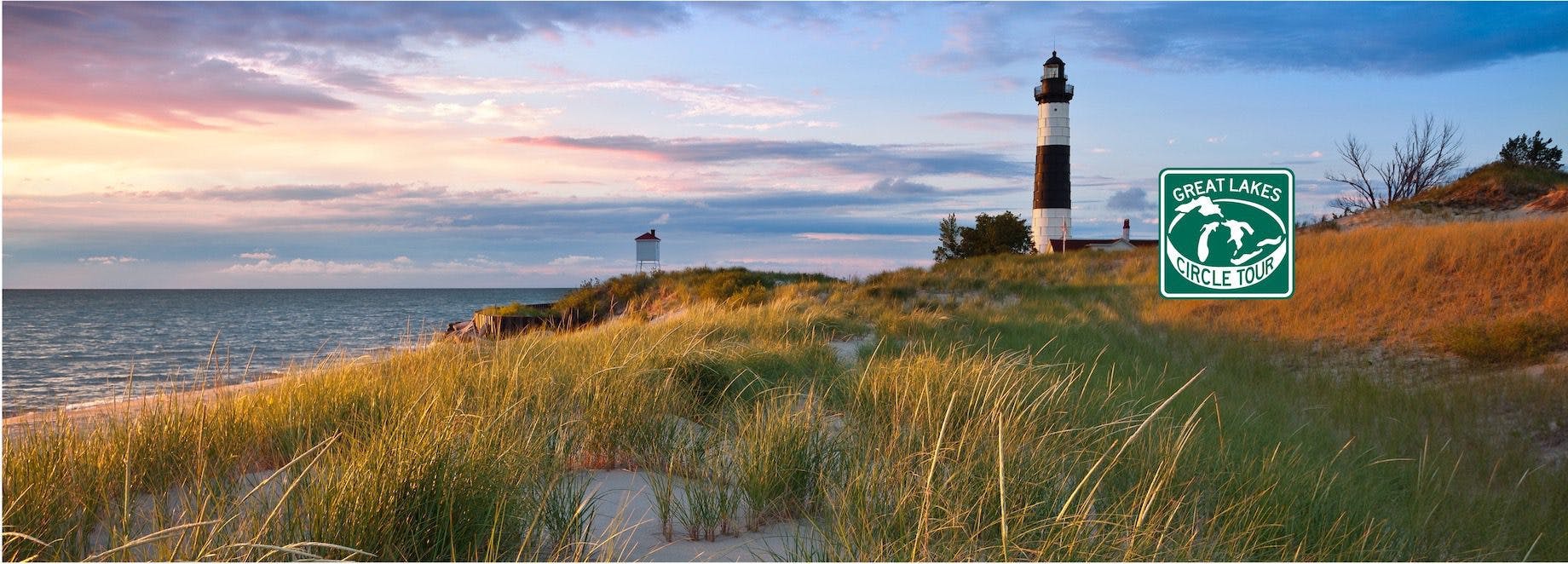
North Pier Lighthouse, Presque Isle State Park

Lake Erie’s Presque Isle State Park near Erie, PA isn’t to be missed. This ancient sand spit extending into Lake Erie was made famous by Commodore Perry, who sheltered here while building the ships with which he won the 1812 Battle of Put-In Bay, the biggest naval battle of the War of 1812.
The peninsula now offers beaches, nature trails, kayaking and wildlife preserve, along with the picturesque Presque Isle Lighthouse .
The Lake Erie Coastal Ohio Trail meanders past a number of parks and beaches, ferry rides to islands, historic lighthouses and nostalgic roadside attractions.
The Ontario side of Lake Erie features Long Point National Wildlife Refuge jutting from the mainland on a narrow sliver of land. Travelers turn north along the Detroit River, through Detroit/Windsor and around Lake Saint Clair, continuing north along the St. Clair River to the southern end of Lake Huron.
Great Lakes Soo Locks

Lake Huron is the second largest of the Great Lakes. Both the Michigan and Ontario sides of Lake Huron are supplied with scenic lakeshore drives.
The Michigan shoreline follows the “mitten” outline around the “thumb” and on to its highest point at the Straits of Mackinac where Lake Huron meets Lake Michigan. Picturesque lighthouses dot the Lake Huron shoreline, many of them originally built early in the 19th century.
The Ontario portion includes Georgian Bay and is particularly well-supplied with provincial parks.
The two sides meet at the Saint Mary’s River, leading to the twin cities of Sault Ste Marie, Ontario and Sault Ste Marie, Michigan. Here, a series of locks enable Great Lakes freighters to traverse the rapids and enter the lower Great Lakes from Lake Superior. Tours of the Soo Locks are available in the warmer months.
Pictured Rocks National Lakeshore

Lake Superior is the largest, deepest, coldest and least developed of the Great Lakes. The Whitefish Point Light is the oldest operating lighthouse on Lake Superior and the home of the Great Lakes Shipwreck Museum.
The 80-mile stretch west from Whitefish Point to Munising is known as the ‘Shipwreck Coast,’ with over 550 known shipwrecks recorded and a favorite of divers.
This same stretch of deceptively peaceful and picturesque shoreline is home to Pictured Rocks National Lakeshore , offering some of the best scenery in North America, with giant limestone bluffs towering above the water of the south shore.
At least a hundred waterfalls grace the Upper Peninsula. A trip to Isle Royale National Park is a trip that hardy primitive campers dream about. The Trans-Canada Highway swings north of Lake Superior for some distance through heavily wooded lands with many small lakes. Several provincial parks and nature reserves provide public access to this pristine wilderness area.
Sleeping Bear Dunes National Lakeshore

Lake Michigan is the only Great Lake located entirely within the United States. Starting at the eastern tip of the Upper Peninsula, travelers can follow the scenic lakeshore over 300 miles into Wisconsin.
The Door Peninsula is one of Wisconsin’s most picturesque vacationlands. At Manitowoc, a popular car ferry allows for a “short-cut” across the lake to Ludington, avoiding the larger cities farther south. Once past Gary, Indiana, a stop at Indiana Dunes National Lakeshore is a must.
Heading north along the eastern shoreline, Sleeping Bear Dunes National Lakeshore was named Most Beautiful Place in America in 2011 by ABC’s Good Morning America. Continue north to the Old Mission Peninsula and its world-famous wineries, passing Lake Michigan’s famous yachting harbors and ski resorts along the way.
Restored Fort Michilimackinac, founded in 1715, is open for tours during the summer months. Lake Michigan officially ends at the Straits of Mackinac and the Big Mac Bridge to the Upper Peninsula.

The Great Lakes: Cool Facts and Figures for Kids (and Adults!)
The Great Lakes consist of five lakes (plus a smaller attached one named Lake St. Clair) that are all located in the same area of North America, specifically in the mid-upper area…
Related LakeLubber Posts

5 Amazing Wisconsin Ice Fishing Lakes
- February 17, 2023
- Destinations , Experiences

Sip and Savor Along Lake Erie’s Grape Belt and Wine Trail
- May 3, 2021

Explore the Natural Mysteries of Mono Lake
- December 14, 2020
Lake Erie Circle Tour, Canada: Our Neighbors to the North

Brian Shaney
Crossing the Peace Bridge into Ontario is a mostly benign experience. I present my passport and answer a few questions: “Citizenship?” “How long will you be in Canada?” “Do you have any weapons?” Wait, what? Do I have any weapons? Well, I guess I am an American, and this is Canada. Fair question.
Welcome to Canada, Eh!
Having lived just across the border from Canada for several years, I am more than aware of the contrast between the two countries, physically and otherwise. While the U.S. and Canada do have many similarities—both were shaped by immigration, have wide open spaces as well as large metropolitan areas, and drive on the same side of the road—there is something different about Canada. Perhaps something more relaxed, more polite, or dare I say, more civilized? Whatever it is, once across the border, I do feel differently. The Harley’s growl suddenly seems a bit much, as if I am disturbing the calm or disrupting an otherwise quiet afternoon of curling.
Rumbling through the streets of Fort Erie on the lookout for a place to refuel the beast, I encounter only friendly faces. At the service station, I fill the tank and overhear a cell phone conversation at the pump adjacent to me. At this point, I can’t help but notice that less than a half mile from the U.S. border, the Canadian dialect is in full force.

After topping off the tank, I make my way over to Old Fort Erie, a popular tourist spot on the shore of Lake Erie. Lakeshore Drive, as the name implies, follows the lake south toward the fort. I stop to take a few photos of the Buffalo skyline.
Old Fort Erie is a reconstruction. The original, which was built by the British in 1764, was destroyed by occupying American troops near the end of the War of 1812. The war was largely perceived by Canadians as an American attempt to annex land and expand U.S. territory. Many of the battles were fought on the shores of Lake Erie. Now operated by the Niagara Parks Commission, it is open daily during the summer months when visitors are free to tour the buildings and grounds.
Continuing along, it has come to my attention just how American my bike is when I notice that my odometer only tracks in miles per hour. This being Canada, kilometers are the rule of thumb. Attempting to put my long-dormant conversion skills to use, I recall that one kilometer is equal to roughly .62 miles and round to .6 miles to make the math easier. I figure that it should stand to reason that 50 km/h is roughly 30 mph; 60 km/h equals 36 mph, and so on.

All of this math makes me hungry as it has been several hours since I’ve had anything to eat. I stop in the town of Ridgeway for a quick bite. No chain eateries here, which is just fine. There are many local establishments to choose from. At a small roadside stand, I opt for a hot dog and poutine, a uniquely Canadian dish made up of French fries, gravy, and cheese curds.
Small Towns, Small Tank
Farther down the road where the trail leads me back to trace the now rocky shore of Lake Erie, I pass through the towns of Crystal Beach and Port Colborne. Modest homes and cottages dot the narrow two-laner. I pass private campgrounds and RV parks, a sure sign that this area is a haven for those looking to escape city life during the warmer months.
Beyond Port Colborne, the road begins to take on a whole new personality. Before long I find myself diving, rising, twisting, and turning on absolutely pristine pavement. I’m so enthralled at times that I find myself dragging my pegs in a few of the tighter turns; certainly nothing unheard of on a Sportster, but a first for me. The route occasionally strays from the water’s edge and goes by farmland where corn and other crops appear to be nearly ready to harvest.

The towns of Lowbanks, Dunnville, Selkirk, and Port Dover lead me to Port Rowan, where I stop to rehydrate and refuel. The little tank on the Sportster and no fuel gauge have me playing it safe, and I’ve made a habit of filling up every 100 to 125 miles. Petrol stations on the Canadian side of the lake aren’t on every corner, and it’s a good idea to plan accordingly.
On both sides of the lake, wind turbines are a common sight. I notice several roadside signs with messages clearly in opposition to the turbines, and they’ve piqued my curiosity; so I ask the attendant at the service station about them. He tells me that there are some ecological and public health concerns being expressed from those living in proximity; so much so that there have been organized protests by those looking to shut down the wind farms permanently.
Great Lakes Circle Tour
Explore the breathtaking beauty of the Great Lakes and embark on the unforgettable Great Lakes Circle Tour. This nine-day, 2,500-mile journey takes you on a captivating adventure around the five magnificent Great Lakes: Michigan, Erie, Ontario, Superior, and Huron, including the iconic Niagara Falls.
The tour begins with a thrilling ride to Wisconsin and continues northward to Minnesota, where you’ll cross the Canadian border. Experience the thrill of navigating the winding roads that offer captivating views of the historic lakes and their surroundings. As you venture back into the United States, you’ll make a stop in New York to witness the awe-inspiring Niagara Falls. From there, your journey will lead you from the East Coast back to the Midwest, completing the mesmerizing circle. This tour promises a wealth of spectacular scenery, breathtaking vistas, and entertaining attractions.
Day 1: Departure - Arrival Chicago, IL
Upon the arrival of all tour participants, we will gather for a welcome reception, complete with refreshments, to formally kick off our adventure together. This initial gathering serves as the perfect opportunity for introductions among all tour participants and our tour leaders. The focus of the evening is on fostering connections and getting acquainted with one another in a relaxed and friendly atmosphere.
Day 2: Chicago - Eau Claire, Wi
As soon as everyone is geared up and ready on their motorcycles, we set off on our extensive journey spanning approximately 2,440 miles. The bustling city of Chicago fades into the distance as we cruise into the picturesque landscapes of Wisconsin. Our route takes us toward Eau Claire, where we will spend our first evening together. This marks the beginning of our shared adventure, offering a chance to experience the camaraderie and excitement of the open road. Eau Claire, with its welcoming atmosphere and scenic beauty, provides the perfect backdrop for our group to bond and reflect on the journey ahead.
Day 3: Eau Claire - Thunder Bay, Ontario, Canada
Today, our journey will take us across the Canadian border as we embark on a northern adventure. Our route leads us through the scenic Chequamegon-Nicolet National Forest before we make a brief stop in Duluth. Here, we’ll take a moment to appreciate the breathtaking beauty of Lake Superior, our first glimpse of this magnificent body of water.
As we continue along Highway 61, hugging the shores of Lake Superior, you’ll savor the initial leg of our captivating drive. Eventually, we’ll cross into Canada, heading toward Thunder Bay, renowned for its extensive ski jump slopes, steeped in legendary tales of winter sports prowess. Get ready for an unforgettable journey filled with natural wonders and thrilling vistas as we explore the landscapes of the Great North.
Day 4: Thunder Bay - Wawa, Ontario, Canada
Our enchanting journey persists as we traverse along Highway 17, tracing the mesmerizing contours of Lake Superior’s shoreline. Our route guides us past the stunning Pukaskwa National Park, where natural beauty unfolds at every turn. As we venture onward, we approach the charming town of Wawa, nestled near the majestic Lake Superior and the equally captivating Lake Superior Provincial Park. Prepare to be captivated by the wonders of this region as our adventure unfolds along this picturesque route.
Day 5: Wawa - Sudbury, Ontario, Canada
Our journey continues southward, tracing the awe-inspiring eastern shores of Lake Superior and leading us deep into the heart of Lake Superior Provincial Park. Here, we’ll be treated to a breathtaking ride through remote, untouched landscapes adorned with pristine lakes and lush forests.
Upon reaching Sault Ste. Marie, a historic town straddling the border between the United States and Canada, we’ll pause for a delightful lunch alongside the iconic Sault Ste. Marie Canal. This canal serves as a symbolic division between the two countries, offering a unique dining experience.
Turning our direction east, we’ll resume our scenic trek along the US-Canada border, relishing the beauty of the surrounding landscapes. Our day’s journey concludes in Greater Sudbury, the largest city in Northern Ontario. Here, we’ll immerse ourselves in the local culture by dining at a neighborhood eatery in this historic mining town. Get ready for a night filled with true Canadian folklore and local flavor.
Day 6: Sudbury - Ottawa, Ontario, Canada
Our thrilling journey persists as we venture along Canada’s scenic Hwy 148. En route, we relish the picturesque vistas while tracing the shores of Lake Nipissing, adding another dimension of natural beauty to our expedition.
Following our scenic drive, we’ll reach Canada’s renowned capital city, Ottawa. Here, we’ll dedicate the evening to exploring the captivating sights and sounds that this fascinating urban hub has to offer. Get ready for an exciting evening of discovery in Ottawa as we immerse ourselves in the heart of the nation’s capital.
Day 7: Ottawa - Victor, NY
Today marks our departure from Canada as we journey southward, returning to familiar US terrain. Our route takes us towards the picturesque Alexandra Bay, where we commence a scenic ride along the enchanting shores of Lake Ontario.
As our adventure progresses, we’ll continue on to Victor, where we’ll settle in for the evening. In this charming destination, we’ll have the opportunity to unwind and savor the surroundings after a day of exploration. Get ready for a peaceful evening in Victor, as we reflect on the memorable experiences of our journey thus far.
Day 8: Victor - Niagara Falls - Hamburg, NY
Today, our destination is the iconic Niagara Falls, a legendary natural wonder. We will explore the awe-inspiring Niagara Falls National Park, where the breathtaking views and stunning scenery will leave us in absolute awe. We’ll make sure to allocate plenty of time to soak in the beauty and capture every lasting impression with our cameras, as this experience is not to be missed.
After immersing ourselves in the splendor of Niagara Falls, our journey continues to Hamburg, a town with a namesake shared with its German counterpart. Get ready for an intriguing journey that combines the majesty of nature with the charm of cultural history.
Day 9: Hamburg - Freemont, OH
Today’s adventure takes us along the shores of yet another of the Great Lakes, Lake Erie. We’ll embark on a captivating journey that spans the entire day, covering more than 250 miles of this magnificent lake’s coastline.
Our first pit stop will be in Cleveland, where we can explore and enjoy the vibrant atmosphere of this iconic city. Afterward, we’ll continue our scenic ride, eventually reaching our final destination in Fremont. Get ready for a day filled with breathtaking views, serene waters, and memorable experiences as we traverse the stunning landscapes along Lake Erie.
Day 10: Freemont - Chicago, IL
As every great adventure must eventually come to a close, today marks the culmination of our journey. It’s our last riding day, and we’ll be making our way back to Chicago.
We’ll embark on the final leg of our trip, heading towards Lake Michigan and the vibrant city of Chicago. Upon our arrival, we’ll return our bikes and transition back to our regular gear. To celebrate our unforgettable Great Lakes ride and bid farewell to this remarkable adventure, we’ll come together for a memorable farewell dinner. It’s a time to reflect on the incredible experiences we’ve shared and the memories we’ve created along the way.
Day 11: Departure Chicago - Home Travel
As our Great Lakes and Canada adventures come to an end, it’s time for us to bid farewell and make our way back home. We’ll gather as a group and travel by shuttle to the airport, cherishing the memories of our incredible journey together.
Wishing you a safe and pleasant trip back home, and we sincerely hope to have the pleasure of welcoming you on one of our other tours in the US, South America, Asia, Oceania, Africa or Europe in the future.
Please note: Due to time differences, travelers from Europe will arrive home on the date/day following their departure from the US.
We also want to mention that while this program serves as a guideline for our activities and experiences on the tour, there may be occasional deviations. Rest assured, our dedicated tour leaders will do their utmost to execute the program as described, taking into account feasibility and circumstances. We are committed to continuously improving the program, so you may also encounter pleasant surprises along the way.
- Toll Free: 1-800-347-7126
- Intl: 1-403-259-5447
- Online Check-in
- Agent Portal
Rental Vehicles
- Maxi Travel Camper (TCA)
- Deluxe Van Camper (DVC)
- Super Van Camper (SVC)
- Compact Motorhome (MHC)
- Midi Motorhome (MHB)
- Maxi Motorhome (MHA)
- Maxi Plus Motorhome (MHX)
Special Offers
- Relocation Offers
- 2025 Early Booking Deals
- My CanaDream
- Liability Reduction Options
- How To Videos
- Travel Extras
- Temporary Accommodation
- Book Now Pay Later
- Payment Options
- Free Winter E-Book
- CanaDream Cares
Go Global with THL
- 30 Years of CanaDream
Be Inspired
- Trip Planner
- Destinations
- Itineraries
- Ski Safaris
- Guide Books
Download Our Guides

- Gift Certificates
CanaDream Club
- Hotel & Parking Offers
- Ski Resort Specials
- Premium Partners
- Fuel Savings
- Club App Booking Offers
- Campertunity
- Sustainability
Join the Club
- Be a Campground Partner
- Be an Attraction Partner

- Club Savings
- Discovery Pass
- Explore the Club
- Solis Mobile Hotspot
- View Inventory
- RV Financing
- RV Sales FAQ's
- CanaDream Club for Owners
- Rent Before You Buy
RV Sales Locations
- Truck Camper
- RV Specials
- Certified Winter Ready RVs
Click to Learn More
- Financing your RV
- Certified Adventure Ready
Service & Parts
- Calgary RV Storage
- Halifax RV Storage

- Vehicles Back Vehicles
- Maxi Travel Camper (TCA) Back Maxi Travel Camper (TCA)
- Deluxe Van Camper (DVC) Back Deluxe Van Camper (DVC)
- Super Van Camper (SVC) Back Super Van Camper (SVC)
- Compact Motorhome (MHC) Back Compact Motorhome (MHC)
- Midi Motorhome (MHB) Back Midi Motorhome (MHB)
- Maxi Motorhome (MHA) Back Maxi Motorhome (MHA)
- Maxi Plus Motorhome (MHX) Back Maxi Plus Motorhome (MHX)
- Saver 2 Back Saver 2
- Saver 4 Back Saver 4
- Saver 6 Back Saver 6
- Winter RV Back Winter RV
- Vancouver Back Vancouver
- Calgary Back Calgary
- Toronto Back Toronto
- Montreal Back Montreal
- Halifax Back Halifax
- Edmonton Back Edmonton
- Whitehorse Back Whitehorse
- Hot Deals Back Hot Deals
- Relocation Offers Back Relocation Offers
- Winter Vacation Deals Back Winter Vacation Deals
- Rewards Back Rewards
- 2025 Early Booking Deals Back 2025 Early Booking Deals
- My CanaDream Back My CanaDream
- How To Videos Back How To Videos
- Travel Extras Back Travel Extras
- Temporary Accommodation Back Temporary Accommodation
- Book Now Pay Later Back Book Now Pay Later
- Payment Options Back Payment Options
- Liability Reduction Options Back Liability Reduction Options
- About Back About
- Contact Us Back Contact Us
- Careers Back Careers
- CanaDream Cares Back CanaDream Cares
- CAA Travel Insurance Back CAA Travel Insurance
- FAQs Back FAQs
- Go Global with THL Back Go Global with THL
- 30 Years of CanaDream Back 30 Years of CanaDream
- Blog Back Blog
- Destinations Back Destinations
- Itineraries Back Itineraries
- Camping Back Camping
- Trip Planner Back Trip Planner
- Ski Safaris Back Ski Safaris
- FAQ's Back FAQ's
- Gift Certificates Back Gift Certificates
- CanaDream Guides Back CanaDream Guides
- Explore the Club Back Explore the Club
- CanaDream Club Welcome Video Back CanaDream Club Welcome Video
- Hotel & Parking Offers Back Hotel & Parking Offers
- Premium Partners Back Premium Partners
- Fuel Savings Back Fuel Savings
- Download our App Back Download our App
- Club App Booking Offers Back Club App Booking Offers
- Discovery Pass Back Discovery Pass
- Solis Mobile Hotspot Back Solis Mobile Hotspot
- Campertunity Back Campertunity
- Sustainability Back Sustainability
- Be a Campground Partner Back Be a Campground Partner
- Be an Attraction Partner Back Be an Attraction Partner
- RV Sales Locations Back RV Sales Locations
- RV Financing Back RV Financing
- RV Sales FAQ's Back RV Sales FAQ's
- CanaDream Club for Owners Back CanaDream Club for Owners
- Truck Camper Back Truck Camper
- Class B Back Class B
- Class B+ Back Class B+
- Class C Back Class C
- Trucks Back Trucks
- Certified Winter Ready RVs Back Certified Winter Ready RVs
- Service Back Service
- Parts Back Parts
- Calgary RV Storage Back Calgary RV Storage
- Pricing Back Pricing
- Lot Map Back Lot Map
Get RV Rental Pricing & Availability
- {{pickup.Value}}
- {{dropoff.Value}}
- {{country.CountryNameEnglish}}
Get RV Sales Pricing & Availability
- All RV Types
- {{rvType.Name}}
- All Locations
- {{location.Name}}
- {{sleepCapacity.Name}}
- {{maxPrice.Name}}

Ontario Lake Erie Circle Route
Route - 1550 km / 963 mi
Toronto to niagara falls, niagara falls, niagara falls to long point provincial park, long point provincial park to point pelee national park, point pelee to maumee bay state park (via windsor-detroit bridge), maumee bay state park to kelleys island state park, kelleys island state park.
Spend another day exploring the island today.
Kelleys Island to Cuyahoga Valley National Park
Cuyahoga national park to cleveland, cleveland to lake erie state park, lake erie state park to niagara falls (us side), fourmile creek to toronto, trip details.
Today's journey is just the beginning of your great adventure circling Lake Erie.
Head south-west on the QEW (Hwy 403) towards Hamilton. Niagara Falls is between one and two hours away, depending on traffic. If you'd prefer to travel only a short distance today, there are campgrounds en route to Niagara Falls , including a provincial park campground near Oakville, only 30km south of our Toronto location.
The QEW leaves Hwy 403 at Burlington and makes its way around Lake Ontario and past St. Catharines to Niagara Falls. Most of the campgrounds in the area are along Lundy's Lane. Plan to spend 2 full days here to enable you to experience all this town has to offer.
CanaDream Club Partners:
- Campark Resorts
- Jellystone Niagara Camp Resort
- Whirlpool Jet Boat Tour
- National Helicopters Niagara Grand Tour
- Niagara Helicopters
- Imax Theatre & Daredevil Exhibit
- Canada One Brand Name Outlets Niagara
- Oh Canada Eh! Dinner Show
What you decide to do during your stay in Niagara Falls will most likely depend on your personal interests. Begin with a visit to the stunning falls and, if you desire to see them from a greater height, consider a helicopter sightseeing tour with either Niagara Helicopters or National Helicopters. National Helicopters also offer a range of romantic tours for couples, including winery visits.
When night falls, Niagara comes alive in a different way. Lighting illuminates both the Canadian and American Falls, and on selected days from mid May until mid October, you can view fireworks over the Falls.
- WildPlay Niagara Falls
A full day of heritage and nature awaits as you cruise down the Niagara Parkway, hugging the shore and skirting the Niagara River until you arrive at Old Fort Erie and your first glimpse of Lake Erie itself. A word of caution – if you are planning to follow the Niagara Parkway and Lakeshore Road to Fort Erie, you will need to divert around the rail bridge as it’s too low for RVs to pass under (3.3M clearance) then rejoin Niagara Boulevard past the bridge.
After leaving Fort Erie, continue west through a number of quaint beach suburbs to Port Colborne. If it’s a sunny day, take a trip down to Nickel Beach, one of Port Colborne’s hidden treasures and perhaps take time out for a picnic, a swim or a stroll along the beach before continuing around the north shore to Rock Point Provincial Park.
If you’re a golfer, take a break at Turkey Point provincial park – the only provincial park with a golf course. Our choice for your overnight stay tonight however is at Long Point Provincial Park.
The fastest way to reach Point Pelee National Park is to head inland and join the 401. This route will, however take you away from many of the quaint towns and villages which are the essence of the North shore of Lake Erie. While the Coastal Trail doesn’t exactly follow the coast for much of it’s length, following it is a relaxing drive.
Follow Talbot Trail to Kent Bridge Road then turn off to Rondeau Provincial Park for a visit. After, continue along Talbot Trail towards Leamington and follow the signs to Point Pelee National Park. Point Pelee is the southernmost point of mainland Canada, located on a glacial spit that bites into Lake Erie.
It is possible to visit Pelee Island – a ferry service operates regularly from Leamington – check Ontario Ferries for details. Overnight at Point Pelee National Park Campground.
CanaDream Club Partners:
- Leisure Lake Cottage and RV Resort
Today you begin your exploration of the US sections of Lake Erie. If you're not in a hurry to get there, continue following the Coastal Trail to Amherstburg before skirting the Detroit River into Windsor. Amherstburg is a pretty city, sporting pristine English and contemporary gardens, family fun parks and great hospitality.
If you're in a hurry to reach Maumee Bay, join Highway 3, which will take you right to the Ambassador Bridge - the crossing point from Windsor into Michigan. The Ambassador Bridge will bring you into Michigan south of downtown Detroit. After passing through US border control, keep left and take the Fisher Freeway (Hwy 75) south. Look out for signs to the Henry Ford Museum and Greenfields Village if you wish to stop and visit.
After, head south on I75 bound for Maumee Bay State Park Campground. This State park is a great place to relax. A nature centre there is equipped with interactive displays, a research laboratory and viewing windows.
Overnight at Maumee Bay State Park.
Today you’ll head to Marblehead Lighthouse State Park on 9 acres of land at the east end of the peninsula at the entrance to Sandusky Bay.
Take Hwy 2 south-east following the Lake Erie Coastal Ohio Trail signs branching off onto Hwy 163 (W Lakeshore Dr / W Harbor Road to Port Clinton.
The lighthouse, built in 1821 is popular with photographers and is the oldest lighthouse in continuous operation on the US side of the Great Lakes. Lighthouse Tours are offered during summer months. Picnic tables around the shoreline provide a pleasant place to enjoy the surrounding scenery.
From the Marblehead Lighthouse, return to Marblehead and look for signs to the ferry to Kelleys Island. During the summer months, ferries depart at least every hour. RVs can be carried on the ferry. We suggest you pre-book your campsite at Kelleys Island State Park. Once on the Island, consider touring the world famous Glacial Grooves. If you’re energetic, rent a kayak and paddle around the island. Hike the North Pond Trail or bike the East Quarry Trail.
There’s so much to do on the island that you might like to plan a two-night stay here.
Overnight at Kelleys Island State Park Campground.
Kelleys Island, known as Lake Erie’s Emerald Isle, is a fascinating destination for nature enthusiasts, and a relaxing retreat for vacationers. The island is renowned for its unique geological, ecological, and archaeological features, and popular for its recreational offerings and picturesque landscapes. The 677-acre state park is located on the northern shores of the island. Here you can find sandy beaches, caressed by the gentle waves of Lake Erie, enticing you in for a swim.
For the more adventurous, enjoy summer diving among the many shipwrecks in the area or go sea kayaking and experience Lake Erie's ever changing moods.
Take the ferry back to Marblehead then continue east on 163 to E Bayshore Road and on to Sandusky. Downtown Sandusky has some beautiful historic buildings and an historic waterfront to wander around. If you decide to spend the day at Cedar Point, you should allow approximately two hours to reach Streetsboro from Sandusky or add an extra day to your itinerary and continue exploring the south Erie lakeshore before heading further east.
If you decide to skip Cedar Point, continue along the Lake Erie Coastal Ohio Trail to Huron and Vermilion and explore these areas.
Tonight’s destination is slightly inland from the Lake but worth the detour. Look out for interesting villages as you make your way south-east on back country roads towards Cuyahoga National Park. Stop in Olmsted Falls and take time to wander through David Fortier River Park and view the covered pedestrian bridge spanning the Rocky River.
The area around Cuyahoga Valley National Park is dotted with vineyards and you might like to call into one or two to sample some of the excellent wines produced here.
There is no camping for RVs in the park but there are a number of good RV parks in close proximity.
Welcome to Cleveland. Take in a football game or a behind the scenes stadium tour or watch a baseball game. Or, visit the Rock n Roll Hall of Fame. The West Side Market is a favourite place for shopping fresh produce and the Great Lakes Science Center is a must visit if you have kids.
Feel free to spend more time today in Cleveland before continuing along the Great Lakes Circle Trail to your overnight stop at Lake Erie State Park. Your journey today will take you from Ohio, across the northern tip of Pennsylvania and into New York State.
Along the way, there’s ample time to explore. There are more pretty towns you may like to visit along the route including Geneva on the Lake, a resort community developed over 130 years ago.
Once you cross over into Pennsylvania, continue along Highway 5 to Erie Bluffs State Park. This is the largest undeveloped stretch of Lake Erie shoreline remaining in Pennsylvania. The park has one mile of shoreline, 90 foot bluffs overlooking Lake Erie, fishing, picnicking, hiking, canoeing and kayaking. 15 km further east, take time out to visit Presque Isle State Park, Pennsylvania’s only seashore.
The coastal route continues on for another 20 miles to the New York border. Vineyards and wineries are abundant. From here it’s only a short hop to Lake Erie State Park, your overnight destination.
Niagara Falls on the American side, is less than 2 hours away as you continue along the coast trail towards the city of Buffalo. The coastal route will eventually bring you onto highway I90, across Grand Island and into Niagara Falls. The prime viewing area for the American Falls and Rapids is Prospect Point, which is also home to the Visitor Center, Niagara Adventure Theatre and the Observation Tower.
After experiencing the Falls from the American side we recommend you head north on the Robert Moses Parkway then join 18F at Lewiston to follow the Niagara Gorge to Youngstown and Fort Niagara State Park. Camping is available at nearby Fourmile Creek State Park. Advance reservations are recommended during July and August.
Today marks the end of your Lake Erie Circle Tour. Allow between 1-2 hours for the drive back to Toronto on the QEW Highway.
Plan to spend a couple of days in the Toronto area after dropping off your RV. We'd be happy to drop you at Lester B Pearson Airport so you can catch the airport shuttle downtown or arrange a taxi for you. Toronto is a vibrant city with lots to do and see. Take a helicopter tour over the city, visit the observation deck at the CN Tower, take a one hour cruise on Lake Ontario, step back in history at Casa Loma - the possibilities are endless.
- Toronto Helitours
- Gray Line of Toronto
- Haunted Walks Inc.
- Toronto Harbour Tours
- Mariposa Cruises
- Ripley’s Aquarium of Canada
- Making Waves Boatel
- Yorkdale Shopping Centre
- Real Canadian Superstore
- Stay Inn Etobicoke
- Canada’s Best Value Inn
- Best Western Plus Travel Hotel Toronto
- Holiday Inn Express & Suites Toronto
- Goreski’s Landing Resort
- Shady Acres Cottage and RV Resort
- North Shore RV Park
- Quinte’s Isle Campark
- Kingston Walks
- Ganagoque Boat Line
- 1000 Islands Helicopter Tours
- 1000 Islands Ivy Lea KOA
Other Itineraries in Ontario

- For Commissioners
- For the Media
Great Lakes Circle Tour™: Project Archive
Jan 1988 | Archived Projects , Library , Tourism and Recreation
- Media: North Coast Chronicles Podcast: “Whatever Happened with the Great Lakes Circle Tour?” featuring GLC Deputy Director Tom Crane — click here for a direct link to play the podcast (2023)
- News and photos: Lt. Gov. Quinn bikes Circle Tour to boost Great Lakes tourism (2005)
- Great Lakes Circle Tour™ GLC Briefing Paper (1989)
- GLC Resolution on the Great Lakes Circle Tour™ (1989)
Great Lakes Circle Tour route (view individual lake maps below)
At its Annual Meeting in November 1988, the Great Lakes Commission approved a Great Lakes Circle Tour™ project. The circle tour idea had originated with the Commission’s Tourism and Outdoor Recreation Task Force. This group of state and provincial representatives acknowledged the interstate and U.S. – Canada competitive environment on tourism and sought a cooperative regional project where all jurisdictions could work together. The Circle Tour offers an opportunity to showcase the Great Lakes resource where promotion can be both collaborative and localized. All eight Great Lakes States tourism/travel office directors endorsed the idea.
The Commission formed a Great Lakes Circle Tour™ Task Force and charged it with developing appropriate polices. With the Lake Superior and Lake Michigan Circle Tours already in existence, the Task Force focused on route designation for Lakes Huron and Erie and systemwide signage. The New York Seaway Trail was also established by this time and the Task Force recommended its inclusion in the Circle Tour system. The Seaway Trail is recognized by many as the “gold standard” for its success and promotional efforts. The Task Force recognized that replicating New York’s experience across the Great Lakes Basin may be difficult, especially in the short term. It was agreed that local jurisdictions should have primary promotion responsibilities to be aided by the states and provinces where practical, such as designating routes on official highway maps and referencing it on web sites.
The Task Force produced a full-color “lure piece” brochure and distributed 50,000 copies to the states and Ontario and Quebec. New logos were established for the overall system and Lakes Erie and Huron. A conference was organized in Toledo to present the initiative to the region and gather promotion ideas. Other issues were addressed including signage size which varies with type of roadway and route location – state/provincial trunkline closest the Great Lakes shoreline or connecting waterway. On August 23, 1990 the Great Lake Circle Tour as well as the U.S. portion of the Lake Erie Circle Tour were dedicated at Sandusky, Ohio with the Ohio Governor and the Commission Chairman presiding.
During the decade following dedication, the Great Lakes Commission has organized separate Circle Tours workshops for Lakes Superior, Michigan and Erie where local promotion was the focus. Ohio’s portion of Lake Erie has embraced this idea with county convention and visitors bureaus collaborating on promotion programs and materials including their “Lake Erie Escapades” initiative. The Commission staff has used various forums to describe the Circle Tour and worked with authors as they prepared books on the topic. In one instance, staff worked with the Lake Michigan Carferry Service, Inc. to designate the the cross-Lake Michigan auto ferry as an official spur route for the Lake Michigan Circle Tour.
Lake Erie Map
Lake huron map, lake michigan map, lake ontario map, lake superior map.
Return to the Library main page
If you need help finding library items, project information, or materials from inactive projects, please submit your inquiry here .
Library by Subject
- About the Commission
- Archived Projects
- Air Quality
- Aquatic Invasive Species
- Areas of Concern
- Data and Monitoring
- Economy and Transportation
- ENewsletter
- Habitat and Coastal
- News and Announcements
- Ports and Navigation
- Regional Agreements
- Soil Erosion and Dredging
- Tourism and Recreation
- Water Infrastructure
- Water Quality
- Water Quantity and Use
Michigan Highways: Since 1997.

- Introduction
- Michigan's Route Systems
- Michigan's Route Markers
- Master List 1913-Present
- Historical Overview
- The History of Roads in Michigan
- Act 51 of 1951
- Who Maintains the Highways?
- Related Links
- Individual Route Listings
- Routes 10-19
- Routes 20-29
- Routes 30-39
- Routes 40-49
- Routes 50-59
- Routes 60-69
- Routes 70-79
- Routes 80-89
- Routes 90-99
- Routes 100-119
- Routes 120-139
- Routes 140-159
- Routes 160-179
- Routes 180-199
- Routes 200-229
- Routes 230-249
- Routes 250-696
- Business 2-31
- Business 32-94
- Business 96-496
- County Route Systems
- Intercounty Highways
- Intercounty A-2 - C-81
- Intercounty D-19 - H-15
- Intercounty H-16 - H-63
- Unsigned Trunklines
- Great Lakes Circle Tours
- Forest Highways
- Pure Michigan Byways (Heritage Routes)
- Polar-Equator Trail
- Other Routes
- All In-Depth Articles
- Michigan Left
- Diagonal Highways
- Controlled-Access Highways?
- Memorial Highways
- M-35 & Henry Ford
- National Highway System
- Historic Auto Trails
- Zilwaukee Bridge
- US-31: Berrien County
- US-31: Ottawa County
- What's New?
- Site Map & Search
- Sources & Credits
- Site History
- Corrections & Feedback
- Other Sites

Michigan Highways > Other Routes > Great Lakes Circle Tours > Lake Erie Circle Tour
Lake Erie Circle Tour
Lake erie circle tour route.
In Michigan, the mainline of the LECT follows signed state trunkline routes in its entirety, although in some places the nearest state highway to the Lake Erie may be several miles away. The precise routing of the circle tour mainline:
- The LECT enters Michigan from Ohio on I-75 south of Erie and proceeds northerly toward Monroe and Detroit on I-75 .
- Just inside Wayne Co, the circle tour leaves I-75 at Exit 28 and follows M-85 /Fort Rd through Trenton, Riverview, Lincoln Park and into Detroit.
- The route re-joins I-75 at Exit 43 in southwestern Detroit and continues northeasterly.
- The LECT leaves I-75 at the Ambassador Bridge and crosses into Windsor, Ontario.
- Continue on the Lake Erie Circle Tour into Ontario at the Ontario Highways website.
Back to: Great Lakes Circle Tour page .
Additional Information
- Great Lakes Circle Tour – new website (under construction) from the author of MichiganHighways.org.
- Great Lakes Circle Tour – project archive from the Great Lakes Commission . It was the GLC who originally helped establishe the Great Lakes Circle Tours, however as of the early 2020s, the Commission has seemed to have abandoned the concept and no longer supports the Circle Tours in an active manner.
- Lake Erie Circle Tour (archived) – from the Great Lakes Information Network (GLIN), which "is a partnership that provides one place online for people to find information relating to the binational Great Lakes-St. Lawrence region of North America."
- Ohio's Lake Erie Circle Tour (archived) – a tourist-oriented website from the Lake Erie Improvement Association promoting attractions along the Buckeye State's portion of the LECT.
We will keep fighting for all libraries - stand with us!
Internet Archive Audio

- This Just In
- Grateful Dead
- Old Time Radio
- 78 RPMs and Cylinder Recordings
- Audio Books & Poetry
- Computers, Technology and Science
- Music, Arts & Culture
- News & Public Affairs
- Spirituality & Religion
- Radio News Archive

- Flickr Commons
- Occupy Wall Street Flickr
- NASA Images
- Solar System Collection
- Ames Research Center

- All Software
- Old School Emulation
- MS-DOS Games
- Historical Software
- Classic PC Games
- Software Library
- Kodi Archive and Support File
- Vintage Software
- CD-ROM Software
- CD-ROM Software Library
- Software Sites
- Tucows Software Library
- Shareware CD-ROMs
- Software Capsules Compilation
- CD-ROM Images
- ZX Spectrum
- DOOM Level CD

- Smithsonian Libraries
- FEDLINK (US)
- Lincoln Collection
- American Libraries
- Canadian Libraries
- Universal Library
- Project Gutenberg
- Children's Library
- Biodiversity Heritage Library
- Books by Language
- Additional Collections

- Prelinger Archives
- Democracy Now!
- Occupy Wall Street
- TV NSA Clip Library
- Animation & Cartoons
- Arts & Music
- Computers & Technology
- Cultural & Academic Films
- Ephemeral Films
- Sports Videos
- Videogame Videos
- Youth Media
Search the history of over 866 billion web pages on the Internet.
Mobile Apps
- Wayback Machine (iOS)
- Wayback Machine (Android)
Browser Extensions
Archive-it subscription.
- Explore the Collections
- Build Collections
Save Page Now
Capture a web page as it appears now for use as a trusted citation in the future.
Please enter a valid web address
- Donate Donate icon An illustration of a heart shape
Lake Erie journal : guide to the official Lake Erie Circle Tour : Ohio, Michigan, Ontario, New York, Pennsylvania
Bookreader item preview, share or embed this item, flag this item for.
- Graphic Violence
- Explicit Sexual Content
- Hate Speech
- Misinformation/Disinformation
- Marketing/Phishing/Advertising
- Misleading/Inaccurate/Missing Metadata
plus-circle Add Review comment Reviews
42 Previews
DOWNLOAD OPTIONS
No suitable files to display here.
EPUB and PDF access not available for this item.
IN COLLECTIONS
Uploaded by ttscribe4.hongkong on July 13, 2018
SIMILAR ITEMS (based on metadata)
Download the free Kindle app and start reading Kindle books instantly on your smartphone, tablet, or computer - no Kindle device required .
Read instantly on your browser with Kindle for Web.
Using your mobile phone camera - scan the code below and download the Kindle app.

Image Unavailable

- To view this video download Flash Player
Lake Erie Journal: Guide to the Official Lake Erie Circle Tour Paperback – April 1, 2001
- Print length 308 pages
- Language English
- Publisher Big River Pr
- Publication date April 1, 2001
- Dimensions 5.25 x 1 x 8.25 inches
- ISBN-10 0964330946
- ISBN-13 978-0964330948
- See all details

Editorial Reviews
About the author, product details.
- Publisher : Big River Pr (April 1, 2001)
- Language : English
- Paperback : 308 pages
- ISBN-10 : 0964330946
- ISBN-13 : 978-0964330948
- Item Weight : 1.04 pounds
- Dimensions : 5.25 x 1 x 8.25 inches
- Best Sellers Rank: #2,271,290 in Books ( See Top 100 in Books )
Customer reviews
Customer Reviews, including Product Star Ratings help customers to learn more about the product and decide whether it is the right product for them.
To calculate the overall star rating and percentage breakdown by star, we don’t use a simple average. Instead, our system considers things like how recent a review is and if the reviewer bought the item on Amazon. It also analyzed reviews to verify trustworthiness.
No customer reviews
- Amazon Newsletter
- About Amazon
- Accessibility
- Sustainability
- Press Center
- Investor Relations
- Amazon Devices
- Amazon Science
- Sell on Amazon
- Sell apps on Amazon
- Supply to Amazon
- Protect & Build Your Brand
- Become an Affiliate
- Become a Delivery Driver
- Start a Package Delivery Business
- Advertise Your Products
- Self-Publish with Us
- Become an Amazon Hub Partner
- › See More Ways to Make Money
- Amazon Visa
- Amazon Store Card
- Amazon Secured Card
- Amazon Business Card
- Shop with Points
- Credit Card Marketplace
- Reload Your Balance
- Amazon Currency Converter
- Your Account
- Your Orders
- Shipping Rates & Policies
- Amazon Prime
- Returns & Replacements
- Manage Your Content and Devices
- Recalls and Product Safety Alerts
- Conditions of Use
- Privacy Notice
- Consumer Health Data Privacy Disclosure
- Your Ads Privacy Choices
- Agri-tourism & Farmers Markets
- Arts & Culture
- Attractions
- Entertainment & Nightlife
- Experiences & Tours
- Festivals & Fairs
- Garden Centers & Nurseries
- Historic Sites
- Hunting & Fishing
- Kids Activities
- Outdoor Recreation
- Paddle Sports
- Snow Sports
- Spas & Wellness
- Water Parks
- Wedding / Event Venues
- Zoos & Nature Centers
- Bed & Breakfasts
- Campgrounds & RV Parks
- Cottages & Cabins
- Hotels & Motels
- Vacation Rentals
- Confections
- Culinary Tours
- Dinner Cruises & Shows
- Distilleries
- Restaurants
- Transportation
- Meet the Board
- WMTA’s History
- Annual Publications
- Request Free Travel Info
- WMTA’s Sustaining Sponsors
- Newsletter Signup
- Request Travel Info
- Lighthouse Map + Circle Tour
- FREE West Michigan Guide

Lighthouse Driving Itinerary
Home » Lighthouse Map + Circle Tour » Lighthouse Driving Itinerary
Lake Michigan Circle Tour Itinerary Plan
The Great Lakes Circle Tours are a total of four routes circling each Great Lake, with the exception of Lake Ontario. The State of Michigan has signed each of the circle tours for the Great Lakes the state touches: the Lake Erie, Lake Huron, Lake Michigan, and Lake Superior Circle Tours. These tours were originally conceived as an aid for travelers who wished to stick close to the shorelines of the lakes in their journeys. You’ll find the Lake Michigan Circle Tour route below.
Lake Michigan Lighthouse Map & Circle Tour
The Lake Michigan Lighthouse Map & Circle Tour is a free publication available from the West Michigan Tourist Association to accompany the Lake Michigan Circle Tour. Request your free copy of the Lake Michigan Lighthouse Map & Circle Tour .
Lake Michigan Circle Tour Route
Michigan side.
The route of the mainline Lake Michigan Circle Tour in Michigan follows signed state trunkline routes in its entirety, although in some places the nearest state highway to the Lake Michigan may be several miles away. Along with the primary Circle Tour route, several marked “Lake Michigan Circle Tour Loops” have been posted using white-on-brown signs. These loops may follow state highways or utilize city streets and county roads running closer to the shoreline. These loop routes are detailed below the mainline route below:
- The Lake Michigan Circle Tour enters Michigan from Indiana on US-12 south of New Buffalo and proceeds northerly through New Buffalo to I-94.
- The route leaves US-12 and continues northerly on I-94 from Exit 4 toward St Joseph. At Exit 23, the route exits I-94 and continues northerly into downtown St Joseph via BL I-94.
- In St Joseph, the Lake Michigan Circle Tour continues northerly on M-63 into northern Berrien Co.
- At the nothern terminus of M-63, the circle tour proceeds northerly on I-196/US-31 toward South Haven.
- The route leaves I-196/US-31 at Exit 18 and loops through South Haven using BL I-196.
- On the east side of South Haven, where BL I-196 ends at I-196/US-31 Exit 20, the route continues north into Allegan Co on I-196/US-31.
- While the Lake Michigan Circle Tour remains on I-196/US-31 at Saugatuck/Douglas, a locally-designated Lake Michigan Circle Tour Harbor Tour loop route is signed concurrently with A-2/Blue Star Hwy between Exits 36 and 41.
- The circle tour continues northerly on US-31/BL I-196 toward Holland at Exit 44 when I-196 splits off to the east.
- At Exit 47, route signage indicates that the circle tour exits US-31 and loops through downtown Holland following the former route of BUS US-31/BL I-196. However, this business loop route through Holland was removed in August 2004 (signage removed in May 2005), but Lake Michigan Circle Tour markers along US-31 itself still indicates the route exits US-31 onto a business route which no longer exists. Therefore, the new de facto route for the circle tour continues northerly past Holland via the US-31 bypass.
- On the east side of Holland, the route continues northerly following US-31 through Grand Haven and toward Norton Shores.
- At the jct of US-31 & I-96, the Lake Michigan Circle Tour leaves US-31 and follows BUS US-31 through downtown Muskegon.
- Northeast of downtown Muskegon, the route continues northerly via M-120 to North Muskegon and northeasterly back to US-31.
- Back on US-31, the circle tour continues northerly toward Ludington, leaving US-31 twice: once to follow the route of BUS US-31 through the downtowns of Whitehall and Montague in northern Muskegon Co; and again to follow the route of BUS US-31 through downtown Pentwater in Oceana Co.
- At the end of the US-31 freeway near Ludington, the Lake Michigan Circle Tour turns east following US-10/US-31 toward Scottville.
- At Scottville, the circle tour turns northerly again to follow US-31 toward Manistee, although a locally-designated Lake Michigan Circle Tour Loop Route formerly continued east on US-10 into downtown, then northerly via Old US-31 back to US-31 and the Lake Michigan Circle Tour. (NOTE: The Lake Michigan Circle Tour Loop route through Scottville was removed/decommissioned some time in late 2004 or early 2005 and no longer exists.)
- The route continues northerly from Scottville and through Manistee on US-31.
- Northeast of Manistee, the route turns northerly to follow M-22 through Onekama, Frankfort and Empire.
- Northeast of Empire, a Lake Michigan Circle Tour Loop Route leaves M-22 to follow M-109 past Glen Haven, rejoining M-22 at Glen Arbor. (The mainline LMCT remains on M-22 between Empire and Glen Arbor.)
- From Glen Arbor, the circle tour continues northerly on M-22 through Leland to Northport. At Northport, M-22 and the Lake Michigan Circle Tour turn nearly 180 degrees to head southerly into Traverse City.
- At Traverse City, the Lake Michigan Circle Tour returns to US-31 and continues northerly via US-31 through Elk Rapids, Charlevoix and Petoskey and on toward the Mackinac Bridge.
- South of Mackinaw City, where US-31 ends, the route continues northerly on I-75 crossing the Mackinac Bridge and entering the Upper Peninsula at St Ignace. Between Mackinaw City and St Ignace, the Lake Michigan Circle Tour is jointed by the Lake Huron Circle Tour.
- In St Ignace, the Lake Michigan Circle Tour continues westerly along US-2 for more than 140 miles through Manistique and Gladstone to Escanaba.
- At Escanaba, the circle tour continues southwesterly via M-35 along the Green Bay shoreline to Menominee
- The route continues south on US-41 through Menominee and enters Wisconsin at Marinette.
Thanks to Chris Bessert and the Michigan Highways site for the route.
Wisconsin Side
In Wisconsin, the mainline of the Lake Michigan Circle Tour follows signed state highway routes in its entirety, although in some places the nearest state highway to the Lake Michigan may be several miles away. This route listing lists the official route as well as any locally-designated and marked “Lake Michigan Circle Tour Loops,” which are generally posted with brown signs. These loop routes are detailed below the mainline route below:
- The Lake Michigan Circle Tour enters Wisconsin from Illinois via STH-32 and proceeds northerly through the downtowns of Kenosha, Racine and Milwaukee, all the while following STH-32 religiously.
- In northern metropolitan Milwaukee, the LMCT joins I-43/STH-32/STH-57 heading northerly into Ozaukee Co.
- At Grafton, the tour departs I-43 to remain on STH-32 and continues through Port Washington.
- On the north side of Port Washington, the tour rejoins I-43 and contines northerly via I-43/STH-32 toward Sheboygan.
- At Exit 123, the circle tour departs I-43 and continues northeasterly via STH-28 into Sheboygan.
- At STH-23, where STH-28 ends and STH-42 begins, the LMCT continues northwesterly via STH-42 back to I-43 at Exit 128.
- The route continues northerly via I-43 from Sheboygan to Manitowoc.
- At Manitowoc, the circle tour leaves I-43 at Exit 149 and continues into downtown via US-151.
- In downtown Manitowoc, the route continues northerly via US-10 to STH-42. Also in downtown Manitowoc, a rather unique Lake Michigan Circle Tour spur route begins: travelling straight across the lake via Lake Michigan Carferry’s S.S. Badger carferry!
- On the north side of Manitowoc, the tour continues northerly via STH-42 through the communities of Two Rivers, Kewaunee and Algoma into Door Co and the Door Peninsula.
- At STH-57, the Lake Michigan Circle Tour turns northeasterly via STH-42/STH-57 past Sturgeon Bay.
- The route then heads northeasterly along the Lake Michigan side of the peninsula via STH-57 through Jacksonport, meeting back up with STH-42 in Sister Bay.
- In Sister Bay, the Lake Michigan Circle Tour turns back southwesterly via STH-42 through Egg Harbor to Sturgeon Bay once again.
- Southwest of Sturgeon Bay, the tour continues southwesterly via STH-57 into Green Bay.
- At Green Bay, the circle tour transitions to the final seven miles of I-43 northwesterly to that highway’s northern terminus at US-41/US-141.
- The Lake Michigan Circle Tour then turns northerly via US-41/US-141 in Howard.
- A the US-41/US-141 split in Abrams, the circle tour veers northeasterly to follow US-41 through Oconto and Peshitgo on its way to Marinette.
- At Marinette, the Lake Michigan Circle Tour enters Michigan on the US-41 Interstate Bridge linking that city with its sister, Menominee, on the other bank.
Thanks to Chris Bessert and the Wisconsin Highways site for providing the route.
Enter to Win!
Enter to win 4 Family Tickets a Watercolor Painting from Raven Hill Discovery Center!
What's Happening
Graff chrysler dodge jeep ram of rockford and herman’s boy of rockford will co-host their national jeep “go topless” day event.
On Saturday, May 18, 2024, Graff Chrysler Dodge Jeep Ram of Rockford and Herman’s Boy of Rockford will co-host their National Jeep “Go Topless” Day event with a fundraiser for … Read More ►
St. Cecilia Music Center Launches 2024 – 2025 Season Subscription Thursday, April 25, 2024 at 10 a.m.Sales on
St. Cecilia Music Center (SCMC) is announcing the 2024-25 Chamber Music Society of Lincoln Center (CMS) and Spectacular Jazz Series concerts. Both series’ offer outstanding performances by the best chamber music and jazz musicians in … Read More ►
Choose LansingTM Announces New Hire and Promotion
Choose LansingTM grows sales team with new role, promotes existing staff Choose LansingTM is pleased to announce the addition of Abby Feltzer to the team as sales and services coordinator, as well … Read More ►
West Michigan Travel Tips Newsletter Sign Up
Get West Michigan Travel News, Events and Specials delivered to your inbox. Sign up for our WMTA Travel Newsletter.
- Email Newsletter Signup: *
- Overview & Introduction
- Lake Superior Circle Tour
Lake Michigan Circle Tour
- Lake Huron Circle Tour
- Lake Erie Circle Tour
- Great Lakes Seaway Trail
- Other Circle Tours
- Illinois Tourism Info
- Indiana Tourism Info
- Michigan Tourism Info
- Minnesota Tourism Info
- New York State Tourism Info
- Ohio Tourism Info
- Ontario Tourism Info
- Pennsylvania Tourism Info
- Québec Tourism Info
- Wisconsin Tourism Info
- Technical Resources
- Circle Tour Signs & Graphics
- Official Contacts
- History of the GLCT
- All In-Depth Articles
- What's New?
- Site Map & Search
- Sources & Credits
- Corrections & Feedback
- Other Sites
Great Lakes Circle Tour > The Circle Tours > Lake Michigan Circle Tour
Working in conjunction with the Michigan Department of Transportation (MDOT), the West Michigan Tourist Association (WMTA) helped to make the first of the official Great Lakes Circle Tours a reality. On the MDOT side, Jack Morgan, assistant to the department’s deputy director, introduced the concept of a Circle Tour in 1987. Just 14 months later, agreement had been reached on a route and signs to be posted along the 1,100-mile tour completely circling Lake Michigan. The WMTA filled the need for a guidebook and when the Chicago Tribune and Milwaukee Journal ran articles in 1988 about the new Circle Tour, 150 callers from the Chicagoland area along deluged the WMTA staff the next Monday morning, requesting the guide. Two days later, 700 guidebook requests came in from Illinois and Wisconsin and the following day an additional 1,000 phone and mail requests poured in to their offices.
Present-Day Concerns and the Tri-Modal Corridor
In November 2012, the inaugural meeting of the Lake Michigan Trails Conference was convened in Saugatuck by Western Michigan University professor Dave Lembeck. Lembeck is championing both the completion of a Lake Michigan “water trail” for kayakers, canoeists and other paddlers around the lake’s entire shoreline as well as an interconnection between the water trail, the new U.S. Bicycle Route 35 (USBR-35) and the existing Lake Michigan Circle Tour. The envisioned “Tri-Modal Corridor” would accommodate non-motorized transportation and recreation via the “water trail” in the Lake and the bicycle route on land. The LMCT would help link the various bicycle trailheads and water access points together.
Unfortunately, actual signage along the Lake Michigan Circle Tour route has deteriorated over time. While Wisconsin has generally kept the Circle Tour reasonably well posted, signage in Michigan and Illinois is lacking and long segments of the LMCT in Indiana are now completely unsigned. Indeed, when the numbered highways that the Circle Tour ran along were rerouted in Northwest Indiana in recent years, the LMCT route markers were regrettably not relocated or replaced. Furthermore, highway signing standards may have changed to the point where including Circle Tour route markers alongside the other numbered highway markers on freeway signage is no longer allowed or encouraged. While hundreds of the standard Circle Tour markers are still found alongside the roadside in Michigan, some locations where the LMCT changes directions (e.g. transitions from one highway to another) are now under-signed or completely unsigned altogether. This was cited as a major concern by the attendees at the 2012 Lake Michigan Trails Conference.
Conference attendees vowed to support the ongoing efforts of the existing organizations assembling the resources necessary to complete the Lake Michigan Water Trail and the signed U.S. Bicycle Route network now underway around the periphery of the Lake. Additionally, attendees citied a need to renew coordination and oversight of the Great Lakes Circle Tour Program within the various state departments of transportation, the Ontario Ministry of Transportation and the de facto coordinating agency, the Great Lakes Commission. Several of those in attendance pledged resources and a commitment to both preserve the Circle Tour routes and look for ways to improve the coordination and signage into the future. Creating background documentation, documenting and recording the officially-adopted Circle Tour route, clarifying route signage standards and formalizing a route maintenance policy are just some of the concepts put forth in the revitalization of these important tourist routes.
Lack of Official Routing & Erroneous Information
Unfortunately, the Great Lakes Commission's own description of the LMCT is largely incorrect, both in terms of the actual route and because of numerous typos and incorrect community names. For example, as of last check (March 2013), errors in just the "Lake Michigan Circle Tour Road Route" section of the Commission's LMCT page give the following description of the route in Lower Peninsula:
ROUTE: Follow I-96E to Holland; US-31N to Manistee; MI-22 to Traverse City; US-31 to Petoskey; MI-119 to the town of Cross Bridge; C66 to US-31; cross the Mackinaw Bridge (toll) into the Upper Peninsula
The first major issue is to get to Holland from Indiana, one needs to first follow US-12 East (not listed) before transitioning onto I-94 East (not listed), then exit that route and follow BL I-94 and M-63 through St Joseph and Benton Harbor (not listed), transitioning then onto I-196/US-31 North (also not listed!) with a loop through downtown South Haven via BL I-196 (not listed), then back to I-196/US-31 North, before exiting onto US-31 North to reach Holland. On top of that, I-96 doesn't go to Holland at all!
From Holland to Petoskey the directions are somewhat better, although loops through downtown Muskegon, the downtowns of Whitehall and Motague, and through Pentwater via the respective BUS US-31 routings are omitted. However, from Petoskey, the LMCT has never run along M-119 and even if it did, the directions erroneously call the community of Cross Village , Cross Bridge , instead! (It's never been called Cross Bridge since its was founded in 1830!) But after omitting the connection from US-31 onto I-75 once US-31, the name of one of Michigan's most famous landmarks is misspelled: the Mackina c Bridge! If these directions are this bad—and have been since it was first reported to the Great Lakes Commission in the late 1990s (a decade and a half ago!) —how trustworthy is the rest of the information!
Lake Michigan Circle Tour Route
The Lake Michigan Circle Tour (LMCT) enters the state from Indiana southwest of New Buffalo, continues up the east coast of Lake Michigan and crosses the Mackinac Bridge along with the Lake Huron Circle Tour. From St. Ignace, the LMCT heads west across the Upper Peninsula then turns southwesterly to Menominee where it continues into Wisconsin. In Michigan, the 631-mile route generally follows the state trunkline highway running closest to Lake Michigan. The officially designated route for the LMCT is as follows:
- The LMCT enters Michigan from Indiana on US-12 south of New Buffalo and proceeds northerly through New Buffalo to I-94.
- The route leaves US-12 and continues northerly on I-94 from Exit 4 toward St Joseph.
- At Exit 23, the route exits I-94 and continues northerly into downtown St Joseph via BL I-94.
- In St Joseph, the LMCT continues northerly on M-63 into northern Berrien Co.
- At the nothern terminus of M-63, the circle tour proceeds northerly on I-196/US-31 toward South Haven.
- The route leaves I-196/US-31 at Exit 18 and loops through South Haven using BL I-196.
- On the east side of South Haven, where BL I-196 ends at I-196/US-31 Exit 20, the route continues north into Allegan Co on I-196/US-31.
- While the LMCT remains on I-196/US-31 at Saugatuck/Douglas, a locally-designated LMCT Harbor Tour loop route is signed concurrently with A-2/Blue Star Hwy between Exits 36 and 41.
- The circle tour continues northerly on US-31/BL I-196 toward Holland at Exit 44 when I-196 splits off to the east.
- On the east side of Holland, the route continues northerly following US-31 through Grand Haven and toward Norton Shores.
- At the jct of US-31 & I-96, the LMCT leaves US-31 and follows BUS US-31 through downtown Muskegon.
- Northeast of downtown Muskegon, the route continues northerly via M-120 to North Muskegon and northeasterly back to US-31.
- Back on US-31, the circle tour continues northerly toward Ludington, leaving US-31 twice: once to follow the route of BUS US-31 through the downtowns of Whitehall and Montague in northern Muskegon Co; and again to follow the route of BUS US-31 through downtown Pentwater in Oceana Co.
- At the end of the US-31 freeway near Ludington, the LMCT turns east following US-10/US-31 toward Scottville.
- At Scottville, the circle tour turns northerly again to follow US-31 toward Manistee, although a locally-designated LMCT Loop Route formerly continued east on US-10 into downtown, then northerly via Old US-31 back to US-31 and the LMCT. ( NOTE: The LMCT Loop route through Scottville was removed/decommissioned some time in late 2004 or early 2005 and no longer exists. )
- The route continues northerly from Scottville and through Manistee on US-31.
- Northeast of Manistee, the route turns northerly to follow M-22 through Onekama, Frankfort and Empire.
- Northeast of Empire, a LMCT Loop Route leaves M-22 to follow M-109 past Glen Haven, rejoining M-22 at Glen Arbor. (The mainline LMCT remains on M-22 between Empire and Glen Arbor.)
- From Glen Arbor, the circle tour continues northerly on M-22 through Leland to Northport. At Northport, M-22 and the LMCT turn nearly 180 degrees to head southerly into Traverse City.
- At Traverse City, the LMCT returns to US-31 and continues northerly via US-31 through Elk Rapids, Charlevoix and Petoskey and on toward the Mackinac Bridge.
- South of Mackinaw City, where US-31 ends, the route continues northerly on I-75 crossing the Mackinac Bridge and entering the Upper Peninsula at St Ignace. Between Mackinaw City and St Ignace, the LMCT is jointed by the Lake Huron Circle Tour .
- In St Ignace, the LMCT continues westerly along US-2 for more than 140 miles through Manistique and Gladstone to Escanaba.
- At Escanaba, the circle tour continues southwesterly via M-35 along the Green Bay shoreline to Menominee
- The route continues south on US-41 through Menominee and enters Wisconsin at Marinette.
The LMCT enters Wisconsin at Marinette and follows the shore of Green Bay through its namesake city, then runs up nearly the entire length of the Door Peninsula before looping back to continue south along the western shore of Lake Michigan through Kewaunee, Manitowoc, Sheboygan, Milwaukee, and Racine, exiting the state into Illinois south of Kenosha. Approximately 351 miles of the LMCT exist in Wisconsin. The officially signed route for the LMCT is as follows:
- Enters from the State of Michigan via US-41 on the Interstate Bridge in the City of Marinette, Marinette Co.
- Southerly via US-41 through downtown Marinette, continuing southwesterly along US-41 past Peshtigo and Oconto to Abrams.
- At Exit 187, the LMCT continues southerly via US-41/US-141 from Abrams toward Green Bay.
- Southerly at Exit 171 via I-43 through the City of Green Bay via the Leo Frigo Memorial Bridge.
- Northeasterly at Exit 185 to follow WIS-57 from Green Bay past Dyckesville and into Door County.
- At the southernmost junction of WIS-57 & WIS-42, the LMCT actually loops over itself. Continuing along the route in the counterclockwise direction, the LMCT continues northeasterly via WIS-42/WIS-57 past Sturgeon Bay to the second junction of WIS-42 & WIS-57.
- Northeasterly via WIS-57 along the Lake Michigan shore through Jacksonport and Bailey’s Harbor, then northerly into Sister Bay and the third junction of WIS-57 & WIS-42.
- Southwesterly to follow the east shore of Green Bay via WIS-42 through Ephraim, Fish Creek, and Egg Harbor back to the second junction of WIS-42 & WIS-57.
- Southwesterly past Sturgeon Bay via WIS-42/WIS-57 to the first junction of WIS-42 & WIS-57 southwest of Sturgeon Bay.
- Southerly via WIS-42 through Algoma, Kewaunee, and Two Rivers and into Manitowoc.
- Southerly via US-10/BUS WIS-42 into downtown Manitowoc.
- LMCT Spur: Continues southerly, then easterly and northerly via US-10 from downtown Manitowoc to the Lake Michigan Carferry dock.
- Westerly from downtown Manitowoc via US-151/BUS WIS-42 to I-43 at Exit 149.
- Southerly via I-43 from Manitowoc to WIS-42 at Exit 128 northwest of Sheboygan.
- Southeasterly via WIS-42/Calumet Dr from I-43 at Exit 128 into Sheboygan to North Ave.
- Easterly via North Ave to N 3rd St.
- Southerly via N 3rd St to Lincoln Ave.
- Easterly via Lincoln Ave to Boughton Dr.
- Follows the Lake Michigan shoreline in a generally southerly direction via Boughton Dr to Pennsylvania Ave.
- Westerly via Pennsylvania Ave from Boughton Dr to Riverfront Dr in downtown Sheboygan.
- Southwesterly via Riverfront Dr to S 8th St.
- Southerly across the Sheboygan River via S 8th St to the roundabout at Indiana Ave.
- Easterly for one block via Indiana Ave from the 8th St roundabout to S 7th St.
- Southerly via S 7th St to High Ave.
- Southerly from S 7th Ave & High Ave via Lakeshore Dr to Washington Ave.
- Westerly via Washington Ave from Lakeshore Dr to junction WIS-28 at the intersection of Washington Ave & Business Dr.
- Easterly via WIS-28/Washington Ave from Business Dr to I-43 at Exit 123.
- Southerly via I-43 from Exit 123 southwest of Sheboygan toward Port Washington. (I-43 and the LMCT are joined by WIS-32 at Exit 113 near Cedar Grove.)
- Southerly via WIS-32/Wisconsin St from I-43 at Exit 100 into Port Washington.
- Southerly via WIS-32/Franklin St from Wisconsin St through the Port Washington downtown business district to WIS-32/Grand Ave.
- Westerly via WIS-32/Grand Ave from Franklin St to junction WIS-33 at Spring St west of downtown Port Washington.
- Southwesterly via WIS-32/Spring St from WIS-33 toward I-43 at Exit 93 at Grafton.
- Southerly via I-43/WIS-32/WIS-57 from Exit 93 northeast of Grafton into Milwaukee County.
- Easterly from I-43 at Exit 82 via WIS-32/Brown Deer Rd, then southerly via WIS-32/N Lake Dr through the suburban communities of Bayside, Fox Point and Whitefish Bay and into the City of Milwaukee.
- Westerly via WIS-32/Bradford Ave from N Lake Dr to WIS-32/Farwell Ave.
- Southwesterly via WIS-32/Farwell Ave from Bradford Ave to Franklin Pl, then southerly via WIS-32/Franklin Pl to Prospect Ave. (Northbound LMCT follows WIS-32 Prospect Ave from Franklin Pl to Bradford Ave.)
- Southerly via WIS-32/Prospect Ave to State St.
- Southbound LMCT follows WIS-32/State St westerly from Prospect Ave to US-18/WIS-32/Broadway, then southerly via US-18/WIS-32 Broadway from State St to Michigan St, continuing southerly via WIS-32/Broadway from Michigan St to St Paul St. LMCT southbound then runs easterly via WIS-32/St Paul St from Broadway to WIS-32/Milwaukee St. Northbound LMCT follows WIS-32/Milwaukee St northerly from St Paul St to US-18/Michigan St, then continuing northerly via US-18/WIS-32/Milwaukee St to Wells St. LMCT northbound then continues easterly via WIS-32/Wells St from Milwaukee St to Prospect St, then northerly via WIS-32/Prospect St to WIS-32 Sbd/State St.
- LMCT continues from downtown Milwaukee southerly via WIS-32/Milwaukee St to Menominee & Young Sts.
- Southwesterly via WIS-32/Young St from Milwaukee St to Erie St and via WIS-32/Broadway across the Milwaukee River to Water St.
- Westerly via WIS-32/Pittsburgh Ave to S 1st St.
- Southerly via WIS-32/S 1st St from Pittsburgh Ave to Kinnickinnic Ave.
- Southeasterly via WIS-32/Kinnickinnic Ave from S 1st St to Howard Ave.
- Easterly via WIS-32/Howard Ave from Kinnickinnic Ave to S Lake Dr.
- Southerly via WIS-32/S Lake Dr from Howard Ave to E College Ave.
- Westerly via WIS-32/E College Ave from S Lake Dr to N Chicago Ave.
- Southerly via WIS-32/N Chicago Ave and 10th Ave from E College Ave to Marquette Ave in the City of South Milwaukee.
- Westerly via WIS-32/Marquette Ave from 10th Ave to S Chicago Ave.
- Southerly via WIS-32/S Chicago Ave from Marquette Ave in South Milwaukee to through the City of Oak Creek and into Racine County.
- Southerly via WIS-32/Douglas Ave from Milwaukee County into the City of Racine at Hamilton St.
- Easterly via WIS-32/Hamilton St from Douglas Ave to N Main St.
- Southerly via WIS-32/Main St through downtown Racine to 6th St.
- Southbound LMCT continues westerly via WIS-32/6th St from Main St to Washington Ave. Northbound LMCT continues easterly via WIS-32/7th St from Washington Ave to Main St where it continues northerly via WIS-32/Main St.
- Southwesterly from the intersection of 6th St, 7th St & Washington Ave via WIS-32/Washington Ave to Racine St.
- Southerly via WIS-32/Racine St from WIS-20/Washington Ave into the south side of Racine.
- Southerly via WIS-32/Sheridan Rd from Racine Ave into Kenosha County and the City of Kenosha.
- Southerly via WIS-32/Alford Park Dr from Sheridan Rd at Carthage Collage to Sheridan Rd south of Alford Park.
- Southerly via WIS-32/Sheridan Rd from Alford Park Dr through downtown Kenosha and then through Pleasant Prairie.
- Southerly via WIS-32/Sheridan Rd in Pleasant Prairie into Illinois at Russell Rd, entering Winthrop Harbor, Illinois.
The Lake Michigan Circle Tour (LMCT) enters Illinois at Winthrop Harbor in northeastern Lake County and continues south through Zion, Waukegan, Lake Forest, Highland Park, Winnetka and Evanston. In these areas, the LMCT follows the route of Sheridan Rd very closely. Once in the City of Chicago, the Circle Tour joins iconic Lake Shore Drive through the city before exiting the state into Indiana. About 61.9 miles of the LMCT exist in Illinois. The Illinois route of the LMCT route is as follows:
- Enters from the State of Wisconsin via SR-137/Sheridan Rd in the Village of Winthrop Harbor in northeastern Lake County.
- Southerly via SR-137/Sheridan Rd through Winthrop Harbor, Zion and Beach Park to Greenwood Ave in Waukegan.
- Southerly via Sheridan Rd from Greenwood Ave (where SR-137 turns easterly toward the Amstutz Expwy) into downtown Waukegan to Belvidere St.
- Westerly via Belvedere St from Sheridan Rd for one block to S Genesee St in Waukegan.
- Southerly via S Genesee St from Belvidere St for three blocks to SR-137/Sheridan Rd-Amstutz Expwy in Waukegan.
- Southerly via SR-137/Sheridan Rd from S Genesee St in Waukegan to Martin Luther King Jr Dr (Co Rd A-31) in North Chicago.
- Southerly via SR-137/Bobby E Thompson Expwy from Martin Luther King Jr Dr (Co Rd A-31) to SR-137/Buckley Rd in North Chicago.
- Easterly via connecting ramps from SR-137/Buckey Rd-Bobby E Thompson Expwy to Sheridan Rd in North Chicago.
- Southerly via Sheridan Rd from SR-137 ramps in North Chicago to intersection of Sheridan Rd, East Sheridan Rd & McKinley Rd in Lake Bluff.
- Easterly via East Sheridan Rd from Sheridan Rd-McKinley Rd to intersection of East Sheridan Rd, North Sheridan Rd, Moffett Rd & Cambridge Ln in Lake Bluff.
- Southerly via Sheridan Rd through Lake Forest to Westleigh Rd intersection.
- Southeasterly via Sheridan Rd from Westleigh Rd intersection in Lake Forest to intersection of Sheridan Rd, Waukegan Ave & Walker Ave in Highwood.
- Easterly via Walker Ave from Sheridan Rd-Waukegan Rd in Highwood to Oak St in Highland Park.
- Southerly via Oak St from Walker Ave for two blocks to Edgecliff Dr.
- Easterly via Edgecliff Dr from Oak St for one block to Sheridan Rd.
- Southerly via Sheridan Rd from Edgecliff Dr to Central Ave in downtown Highland Park.
- Southwesterly via Central Ave for one short block in downtown Highland Park from Sheridan Rd to St Johns Ave.
- Southerly via St Johns Ave from Central Ave in downtown Highland Park to Sheridan Rd.
- Southeasterly following the many twists and turns of Sheridan Rd—the road encounters many 90° turns at several intersections in this area—through the rest of Highland Park and the communities of Glencoe, Winnetka, Kenilworth, and WiImette, to the intersection of Sheridan Rd, Ridge Ave & Isabella St in Evanston.
- Easterly via Sheridan Rd from intersection of Ridge Ave & Isabella St for two blocks to Lakeside Ct in Evanston.
- Southerly via Sheridan Rd from Lakeside Ct through the campus of Northwestern University to Chicago Ave in Evanston.
- Southeasterly via Sheridan Rd for four blocks from Chicago Ave to Campus Dr in Evanston.
- Southerly via Sheridan Rd from Campus Dr for three blocks to Forest Ave
- Southwesterly via Forest Ave from Sheridan Rd for one block to Davis St.
- Southerly via Forest Ave from Davis St for four blocks to Burnham Pl.
- Southbound LMCT continues southerly via Forest Ave from Burnham Pl for four blocks to Main St, then runs easterly via Main St from Forest Ave for two blocks to Sheridan Rd where it continues easterly. Northbound LMCT runs northerly from the intersection of Main St & Sheridan Rd via Sheridan Rd for four blocks to Burnham Pl, then runs westerly via Burnham Pl for two blocks to Forest Ave where it continues northerly.
- Easterly via Sheridan Rd from Main St for one block to Clark Square Park, then southerly via Sheridan Rd to South Blvd.
- Easterly from South Blvd, then southerly, then westerly via Sheridan Rd to skirt the edge of Calvary Cemetery and enter the City of Chicago.
- Southerly via Sheridan Rd from Calvary Cemetery to intersection of Devon Ave & N Broadway.
- From the intersection of Sheridan Rd, Devon Ave & North Broadway, the LMCT continues southerly via North Broadway from Sheridan Rd-Devon Ave to intersection of Bryn Mawr Ave & Ridge Ave.
- Southerly via US-14/North Broadway from Bryn Mawr Ave & Ridge Ave to US-41/Foster Ave.
- Easterly via US-41/Foster Ave from US-14/North Broadway to Lake Shore Dr.
- Southerly via US-41/Lake Shore Dr from Foster Ave through downtown Chicago to intersection of Lake Shore Dr, Jeffery Blvd & Marquette Dr in Jackson Park.
- Easterly via US-41/Marquette Dr from Lake Shore Dr & Jeffrey Blvd to intersection of Marquette Dr, E 67th St & S South Shore Dr.
- Southerly via US-41/S South Shore Dr from E 67th St & Marquette Dr for five blocks to intersection of S South Shore Dr, E 71st St, Yates Blvd & Exchange Ave.
- Easterly via US-41/E South Shore Dr from intersection of S South Shore Dr, E 71st St, Yates Blvd & Exchange Ave for two blocks to the eastern intersection with E 71st St.
- Southeasterly via US-41/S South Shore Dr from intersection of E South Shore Dr & E 71st St for nine blocks to intersection of S South Shore Dr, E 79th St & S Lake Shore Dr.
- Southeasterly then southerly and then southwesterly via US-41/S Lake Shore Dr from intersection of S South Shore Dr & E 79th St to intersection of S Lake Shore Dr, S Mackinaw Ave, Ewing Ave & Harbor Ave.
- Southeasterly via US-41/Ewing Ave from intersection of S Lake Shore Dr, S Mackinaw Ave & Harbor Ave, across the Calumet River to intersection of Ewing Ave & US-12/US-20/E 95th St.
- Southeasterly then southerly via US-12/US-20/US-41/Ewing Ave from 95th St for five blocks to Indianapolis Ave.
- Southeasterly via US-12/US-20/US-41/Indianapolis Ave from Ewing Ave into Indiana at State Line Ave, entering Hammond, Indiana.
The Lake Michigan Circle Tour (LMCT) enters Indiana at Hammond in northwestern Lake County and continues easterly through Whiting, East Chicago, Gary, Burns Harbor, and Michigan City before exiting the state into Michigan. About 46½ miles of the LMCT exist in Indiana.
Note: Route signage for the Indiana segment of the Lake Michigan Circle Tour is missing in most areas of the route.
- Enters from the State of Illinois via US-12/US-20/US-41/Indianapolis Blvd in the City of Hammond in northwestern Lake County.
- Southeasterly via US-12/US-20/US-41/Indianapolis Blvd from the Illinois state line to US-41/Calumet Ave.
- Southeasterly via US-12/US-20/Indianapolis Blvd from US-41/Calumet Ave in Whiting to US-12/Columbus Dr in East Chicago.
- Easterly via US-12/US-20/Columbus Dr from Indianapolis Blvd to SR-912/Cline Ave on the East Chicago/Gary municipal boundary.
- Southerly via SR-912/US-12/Cline Ave from Exit 6 at Columbus Dr to US-20/Michigan St-5th Ave at Exit 10AB.
- Easterly via US-12/US-20/5th Ave from SR-912/Cline Ave to Bridge St in Gary.
- Through downtown Gary, the eastbound LMCT continues easterly via US-12/US-20/5th Ave from Bridge St to Vermont St where it rejoins with the westbound LMCT. The westbound LMCT continues westerly from Vermont St via 4th Ave to Bridge St, then continues southerly for two blocks via US-12/US-20/Bridge St from 4th Ave to 5th Ave where it rejoins with eastbound LMCT.
- East of downtown Gary, the LMCT continues southeasterly via US-12/US-20/Dunes Hwy from Vermont St to the US-12 & US-20 “split” at Dunes Hwy & Melton Rd.
- Easterly via US-12/Dunes Hwy from US-20/Melton Rd in Gary through Portage, Ogden Dunes, Burns Harbor, and Porter to intersection of Dunes Hwy, County Line Rd & Woodlawn Ave on the western limits of the City of Michigan City.
- Northerly via US-12 from intersection of Dunes Hwy, County Line Rd & Woodlawn Ave to Beverly Dr, then easterly via US-12 into Michigan City at Sheridan Ave.
- Northeasterly via US-12/4th St from Sheridan Ave to intersection of 4th St, Willard Ave & Michigan St.
- Northeasterly via US-12/Michigan St and easterly via US-12/Michigan Blvd from 4th St & Willard Ave through downtown Michigan City to 2nd St at Blue Chip Dr.
- Northeasterly via US-12 from Blue Chip Dr to SR-212.
- Northeasterly via US-12 from SR-212 into Michigan at the state line, entering New Buffalo Township, Michigan.
Lake Michigan Circle Tour Loop Routes
Lake michigan circle tour - harbor tour (saugatuck/douglas).
A locally-designated loop route which helps circle tour motorists navigate into and through the off-route communities of Saugatuck and Douglas in northwestern Allegan Co. While most local loops are designated as "Loop Routes" off the mainline circle tour, this particular route is actually designated as a "Harbor Tour," although it behaves like any other Loop Route. Also, as with all Loop Routes, this route is designated with white-on-brown circle tour signs, using the same LMCT "logo." The route is 7.7 miles long:
- The LMCT Harbor Tour begins at I-196/US-31/LMCT at Exit 34 near Ganges (south of Douglas).
- The Harbor Tour route proceeds easterly from the freeway along M-89/124th Ave to A-2/Blue Star Hwy.
- The route turns northerly on A-2 /Blue Star Hwy into Douglas, passing just west of the downtown area.
- The loop route then crosses into Saugatuck, still via A-2/Blue Star Hwy, passing just east of the downtown.
- The route ends when it meets back up with I-196/US-31/LMCT at Exit 41 northeast of Saugatuck.
Lake Michigan Circle Tour - Spur Route (Ludington-Manitowoc)
This Lake Michigan Circle Tour spur route utilizes the S.S. Badger carferry traversing the middle of Lake Michigan between Ludington and Manitowoc.
- Departs LMCT at the west junction of US-10 & US-31 east of Ludington.
- Westerly via US-10/Ludington Ave from US-31 to James St into downtown Ludington.
- Southerly via US-10/James St from Ludington Ave to the S.S. Badger carferry docks in Ludington.
- LMCT Spur officially continues via the S.S. Badger carferry across Lake Michigan, connecting with the LMCT mainline in downtown Manitowoc, Wisconsin.
- From the S.S. Badger carferry docks in Manitowoc, LMCT Spur continues southwesterly via US-10/Lakeview Dr to Lake St.
- Westerly via US-10/Madison St from Lakeview Dr for two blocks to 8th St.
- Westbound LMCT Spur continues northerly via wbd US-10/8th St from Madison St for four blocks to junction US-10, US-151 & BUS WIS-42, where it terminates. Eastbound LMCT Spur departs LMCT at junction US-10, US-151 & BUS WIS-42 at the intersection of Washington St & 10th St and continues southerly via ebd US-10/10th St for four blocks to Madison St where it continues easterly for two blocks via US-10/Madison St from 10th St to 8th St where it rejoins the westbound LMCT Spur.
Lake Michigan Circle Tour - Loop Route (Sleeping Bear Dunes)
While the Lake Michigan Circle Tour generally follows the closest posted state trunkline to its namesake body of water, the Sleeping Bear Dunes area is one exception. Instead of diverting the mainline LMCT off M-22 for only eight miles, it continues via M-22 through to Glen Arbor and on to Leland. However, as M-109 loops off M-22 to the west (lakeside) through the Sleeping Bear Dunes area, it has been designated as a LMCT Loop Route. The route is 6.8 miles long:
- The LMCT Loop Route begins at the southern jct of M-22 & M-109 just northeast of Empire and continues northerly toward Glen Haven.
- At Glen Haven, the loop route turns east and continues on M-109 toward Glen Arbor.
- The LMCT Loop Route ends at the northern jct of M-22 & M-109 in Glen Arbor.
Back to: The Circle Tours .
Additional Information
- Lake Michigan Circle Tour - listing from MichiganHighways.org .
- Lake Michigan Circle Tour History - from the West Michigan Tourist Association (WMTA). The WMTA helped to coordinate the first of the Great Lakes Circle Tours in the 1980s.
- Great Lakes Circle Tour - information from the Great Lakes Commission . It was the GLC who originally established the Great Lakes Circle Tours and continues to provide information on many aspects of the Great Lakes region.
- Lake Michigan Circle Tour - from the Great Lakes Information Network (GLIN), which "is a partnership that provides one place online for people to find information relating to the binational Great Lakes-St. Lawrence region of North America." Please note that the "Circle Tour Road Route" description from the GLIN site is not only vague, but incorrect! (See description above.)
- --> Shoreline Charms (via archive.org )- an article by Donna Marchetti about the Lake Michigan Circle Tour from the Michigan Living magazine published by AAA Michigan.
Copyright © 1997-2014 Christopher J. Bessert. All Rights Reserved. | [email protected] | Last updated Thursday, May 15, 2014 .
IMAGES
COMMENTS
The 629-mile (1,012 km) Lake Erie Circle Tour (LECT) circles the second-smallest Great Lake, spanning four U.S. states and the Canadian province of Ontario in the process. The LECT is the most recent of the four designated Great Lakes Circle Tours, being signed in 1990. The portions of the route in New York and Pennsylvania share the route of ...
The Lake Erie Circle Tour (LECT) loops around Lake Erie following state and provincial highways. These highways are usually the closest to the lake. The LECT follows state highways in the US states of New York, Pennsylvania, Ohio, and Michigan and provincial highways in the Canadian province of Ontario.
The complete Lake Erie Circle Tour covers 680 miles. The AAA-suggested route is from Detroit, Michigan (where you can visit the shores of Belle Isle first) to Toledo, Ohio eastward across the state, across a short portion of Pennsylvania, where you might see the Northern Lights some nights at Presque Isle, up through New York to Niagara Falls, and across the Peace Bridge to Ontario Province ...
A guide to explore the five interconnected freshwater lakes of the Great Lakes in the US and Canada, from Duluth, Minnesota, to Niagara Falls, Ontario. Find tips on food, lodging, hikes, waterfalls, cruises, lighthouses, and more outdoor activities for each lake.
Learn about the history, features and attractions of the scenic routes encircling Superior, Michigan, Huron and Erie, the four Great Lakes. Find travel and tourism information, technical specifications and more on the Great Lakes Circle Tour website.
A motorcycle adventurer shares his experience of circumnavigating Lake Erie from Detroit to Buffalo, passing through various cities, towns, and islands along the way. He describes the culture, history, and attractions of each place, as well as the challenges and rewards of the trip.
A multiday international circle tour of our Great Lake offers something for every traveler, including wineries, history, city lights, natural delights, beaches and fun in, on or next to the water. From Columbus, a complete circle tour of the lake requires at least 12 hours of driving in total. So allow three or four days for a leisurely ...
The Lake Superior Circle Tour was the first route established in 1986, with Michigan following in 1987, then Huron and Erie following in the early 1990s. In 1985, Michigan First Lady Paula Blanchard, an advisor to the Michigan Department of Commerce at the time, pitched the idea to establish a tour route around Lake Superior at a tourism ...
The Lake Superior Circle Tour was the first route established in 1986, with Michigan (1987) following along with Huron and Erie in the early 1990s. The links below lead to specific information and precise routings for each of the Circle Tours: Lake Erie Circle Tour
Lake Erie Circle Tour. Lake Erie Circle Tour. Sign in. Open full screen to view more. This map was created by a user. Learn how to create your own. ...
In 1988, the Great Lakes Commission approved a Great Lakes Circle Tour to create a scenic, international road system connecting all five lakes and the St. Lawrence Seaway. ... The Lake Erie Coastal Ohio Trail meanders past a number of parks and beaches, ferry rides to islands, historic lighthouses and nostalgic roadside attractions. ...
A travelogue of a motorcycle trip around Lake Erie, the largest lake in North America, from the U.S. border to the Canadian border. The author shares his experiences of crossing the border, visiting Old Fort Erie, riding the scenic route, and meeting the locals. The article includes photos, maps, and tips for planning your own trip.
Explore the breathtaking beauty of the Great Lakes and embark on the unforgettable Great Lakes Circle Tour. This nine-day, 2,500-mile journey takes you on a captivating adventure around the five magnificent Great Lakes: Michigan, Erie, Ontario, Superior, and Huron, including the iconic Niagara Falls. The tour begins with a thrilling ride to ...
Overview. Our Circle Lake Erie tour will take you through four states and one province, through wind farms and agricultural land, vineyards and beaches. Historic covered bridges and lighthouses will beckon, calling out to the photographer within you. Get back to nature by hiking or biking in the National Park or try canoeing, kayaking or scuba ...
On August 23, 1990 the Great Lake Circle Tour as well as the U.S. portion of the Lake Erie Circle Tour were dedicated at Sandusky, Ohio with the Ohio Governor and the Commission Chairman presiding. During the decade following dedication, the Great Lakes Commission has organized separate Circle Tours workshops for Lakes Superior, Michigan and ...
Lake Michigan Circle Tour - The second Circle Tour route created and the only one wholly inside the U.S. Lake Huron Circle Tour - The only Circle Tour existing in just two jurisdictions. Lake Erie Circle Tour - The route encircling the smallest Great Lake. Great Lakes Seaway Trail - A related touring route in New York State and Pennsylvania.
The LECT enters Michigan from Ohio on I-75 south of Erie and proceeds northerly toward Monroe and Detroit on I-75. Just inside Wayne Co, the circle tour leaves I-75 at Exit 28 and follows M-85 /Fort Rd through Trenton, Riverview, Lincoln Park and into Detroit. The route re-joins I-75 at Exit 43 in southwestern Detroit and continues northeasterly.
Lake Erie is also the shallowest and warmest of the five lakes, reaching 64 meters at its deepest point and averaging a temperature of 52.4 degrees Fahrenheit (11.3 degrees Celsius). Its depth and temperature cause Lake Erie to hold the shortest water residence time among the five Great Lakes, averaging only 2.6 years of water residency. ...
The Lake Erie Circle Tour is a designated 700-mile motor route through Ontario, New York, Pennsylvania, Ohio and Michigan. this intriguing tour meanders through a region rich with some of the most popular tourist attractions in four states and a Canadian province, including some of the best fishing and irding in north America and Niagara, the ...
"Lake Erie Journal" is the first travel guide to the designated Lake Erie Circle Tour, a 700-mile marked driving route along the lakeshore in Ohio, Michigan, Ontario, New York and Pennsylvania. This needed book captures the natural, historic and cultural significance of the lakeshore, and all the region has to offer as a travel destination.
These loop routes are detailed below the mainline route below: The Lake Michigan Circle Tour enters Michigan from Indiana on US-12 south of New Buffalo and proceeds northerly through New Buffalo to I-94. The route leaves US-12 and continues northerly on I-94 from Exit 4 toward St Joseph. At Exit 23, the route exits I-94 and continues northerly ...
The Lake Huron Circle Tour (LHCT) traverses a 1,059-mile (1,704 km) route around the second-largest Great Lake through Michigan and Ontario. Those two jurisdictions roughly split the mainline route mileage of the LHCT—55% in Ontario and 45% in Michigan. A split-route configuration for the Lake Huron Circle Tour Loop in Ontario also traverses ...
Lake Michigan Circle Tour. The Lake Michigan Circle Tour (LMCT) is 1,092 miles long and is the only Great Lakes Circle Tour that does not cross into Canada, as Lake Michigan is the only Great Lake situated entirely within the U.S. More than half of the LMCT exists within Michigan, while nearly a third of the route occurs within Wisconsin.