

still adventuring with kids
Day 3 tour du mont blanc blog – stage 1 les houches to les contamines or nant borrant.

Tour du Mont Blanc Blog
Our Tour du Mont Blanc blog posts include what to expect day to day on each leg of the half circuit of the Tour du Mont Blanc from Très-Le-Champ in France to Courmayeur in Italy.
Importantly, we talk about realistic hike times trekking with kids and how to slash some of the trail times, making this trek doable as a family. By using some of the public transport along mundane valley stretches or cable cars up and down the mountains, it’s possible to reduce hiking times to save little legs on this epic world classic trek.
This post details Day 3 on our Tour du Mont Blanc itinerary from Les Houches in the Chamonix valley to Les Contamines and further on to the next refuge – Nant Borrant.
Click here to read about the day before – Day 2 La Flégère to Les Houches
Click here to read about the day after – Day 4 Nant Borrant to Les Chapieux

Day 3 (Stage 1) – Les Houches to Les Contamines (and further on to the first refuge Nant Borrant)
6.5 – 7 hours (5 hours from Bellevue plateau to the main road leading to Les Contamines, 30 mins bus journey, 1hr hike up to Nant Borrant)
Hike length:
10km hiking (from the top of Bellevue to Nant Borrant) + 5.9km via bus in-between
Water fill ups?
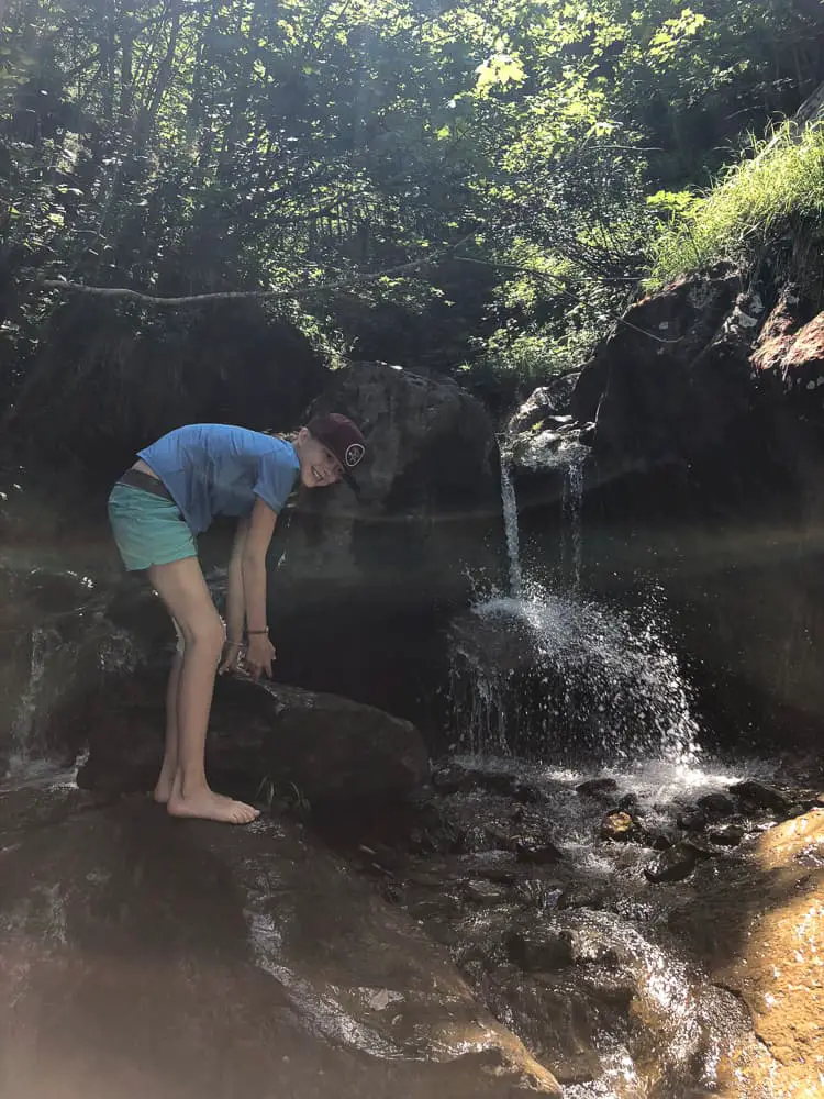
Yes, lots. Stream between Bionnassay & L’Ormey. Water fountains at most hamlets & villages.
Les Houches to Les Contamines is seen as the first official day on the trek, as most people start from Les Houches and trek counter-clockwise which allows you to hike the best direction for the most splendid views of Mont Blanc.
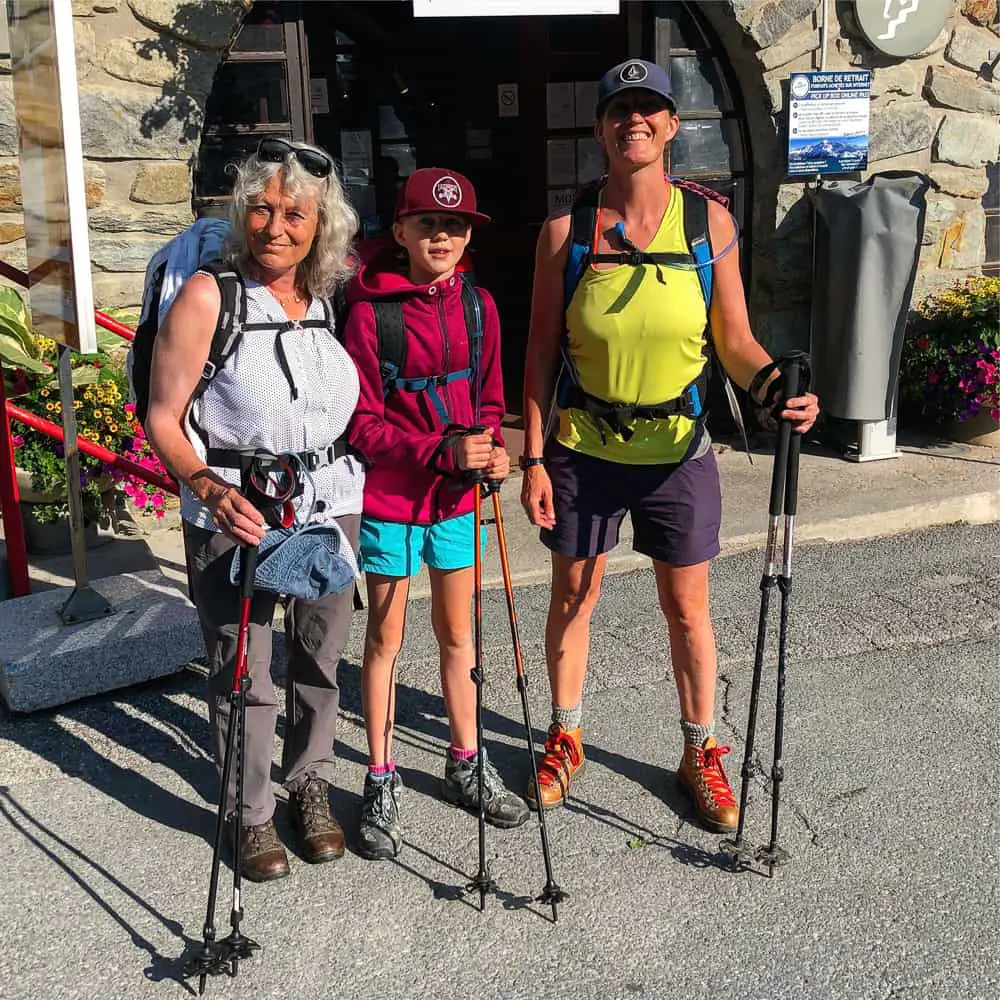
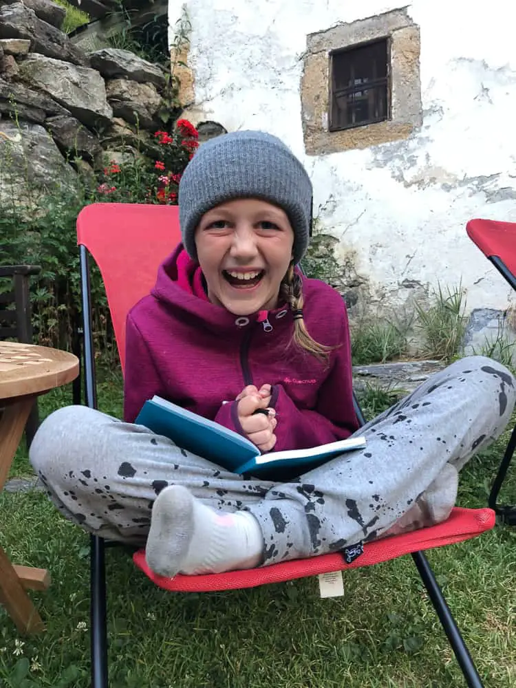
For us it was day 3 as my daughter and I had already done the last couple of stages as day hikes from our home in Chamonix. My Mum flew in to join us in the 4 day hike from Les Houches to Courmayeur so we were excited (and a bit nervous) to be a trio spanning three generations!
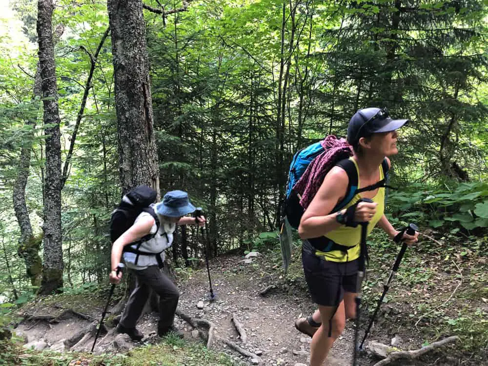
As we’re hiking the tour with a 10 year old, in a bid to make it doable and enjoyable, we’re taking all available transport options. I would highly suggest this if you are contemplating hiking the TMB with kids.
Short cut 1 – Bellevue cable car
The Bellevue cable car at Les Houches cuts out at least two hours of an uphill shleck to Col du Voza on the traditional route. For 14.5 euros (adult) you can cut this section out by taking the Bellevue cable car up to the Bellevue plateau. It’s then just a 20-30 min walk to pick up the main trail. Alternatively you can take the Tramway du Mont Blanc from St Gervais to Col du Voza, but you would need to get a taxi or a bus down the valley from Chamonix to St Gervais for the starting point, which seemed like more of a faff than it was worth.
Short cut 2 – public bus from Le Chapelle to Les Contamines & onto Gorge du Notre Dame
This public bus along the valley floor cuts out 1 hour of hiking into Les Contamine and a further hour if you take it all the way to Gorge du Notre Dame (5.8km of the trail).

Take the Bellevue cable car in Les Houches to cut a good 2 hours of uphill off your trail time today
This short cut turns the first day into mainly downhill taking us approximately 5 hours to Les Contamines. From there catch first the bus on the main road into the centre of Les Contamines which then carries on through Les Contamines and onto Notre Dame de Gorges, the end of the Monjoie Valley, where the trail continues off road up to the first refuge on this section of the trail – Nant Borrant.
We chose not to stay in Les Contamines and continue an hour up the trail as the next stage (tomorrow) is difficult and long with two cols to climb. There are no short cuts from Notre Dame de Gorge to Les Chapieux so we figured we’d try to get ahead on the trail the day before, plus we eager for a mountain hut experience.
We catch the cable car up just before 9am, but I’d recommend setting off at least at 8am everyday as the earlier you reach your accommodation to relax, the better (especially with kids).

The Bellevue cable car whisks you up to the Bellevue plateau. From here it’s only a 20 minute walk to pick up the main TMB track
The cable car only takes around 6 minutes to reach the Bellevue Plateau (1801m).
Use the toilets at the top and get ready for the trail. Take the obligatory photo in front of the first sign post with the stunning view of the Dome du Gouter and the Aiguille Bionnassay in the background.
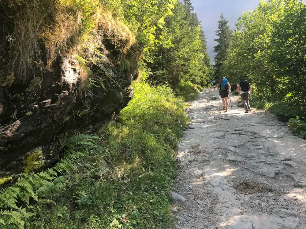
You’ll be following the green TMB signs (which are frequent and well marked) so head downhill to the right signposted Col du Voza. Most signs give you an average hiking time. Whilst this is quite accurate for adult hikers, we found we were adding at least half an hour onto this section. For example it took us almost 2 hours to reach Bionnassay (the signpost indicates 1hr 15 mins).

The Tour du Mont Blanc trail is well signposted. Many signs also tell you average walking times which are fairly accurate
The track is wide and easy as you walk with your back to the Dome du Gouter and Aiguille de Bionnassay. (you can’t quite see Mont Blanc from this angle).
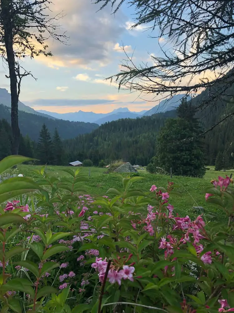
The meadows have cows contentedly grazing with giant bells jangling around their necks secured by wide leather straps. We stride forward to the sound of the pleasant jingling of cow bells – a real alpine feeling that will forever remind us of the Tour du Mont Blanc.

The Bellevue hotel stands empty and alone on the Bellevue plateau. Skirt round it to pick up the main TMB track
Fifteen minutes on and the trail approaches and passes the Bellevue hotel which stands out like a lone soldier on the plateaux. The path continues through meadows of wild flowers down to Col du Voza, where before you the wide ski pistes of the winter dissect the woodland in two.
After half an hour you’ll reach the charming tiny restaurant of La Rioule. We love it here in the Winter where it’s a magical, authentic Savoyarde restaurant crammed with only a few tables, a roaring fire and friendly locals. Today though, with many hours ahead of you on the trail, don’t even think about a stop here unless you’re desperate for an expresso to kick start your day.

Chairlifts, empty and silent, hang over the Col du Voza – a hive of winter ski activity come December
From La Rioule restaurant, you’ll be heading in the direction of Bionnassay and Champel.
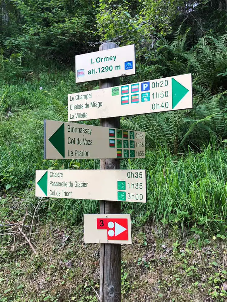
To get a grips with hike times with kids, take a look at the sign below. It might help you to figure your timings. I know I was worrying about how long the stages would actually take with kids so I made sure I recorded our times most of the way, so I could pass this knowledge on.
The sign states 20 minutes to Le Fioux – it took us 30 mins. For Le Crozat it states 30 mins, it took us 1 hr & 12 mins. Whilst for Bionnassay it states 45 mins but took us 1 hr 23 mins. Le Champel took us 2 hrs 50 mins but the sign says 1hr 30.
>>>>> – – – – – >>>>> – – – – – >>>>> – – – – – >>>>> – – – – – >>>>> – – – – – >>>>>
Tour du Mont Blanc Packing List

Tour du Mont Blanc hike times
The track is wide, downhill and pleasant. Not difficult at all. To your left the the stunning vistas of the Aiguille du Bionnassay come back into view and with the walk descending through meadows of wild flowers, we are in good spirits, our feet fresh and strong.
The complete TMB circuit is approximately 107 miles (170 km) and has an altitude gain and loss of over 6.2 miles (10 km) …. which is more than the height of Everest.
Facing you you’ll now see the laces of ski slopes winding down the “Evasion” ski area which joins the ski pistes of both Megeve and Les Contamines – a huge skiable area come winter.

Stage 1 of the Tour du Mont Blanc trek meanders through pleasant alpine pastures and charming villages to a backdrop of the majestic peaks of the Alps
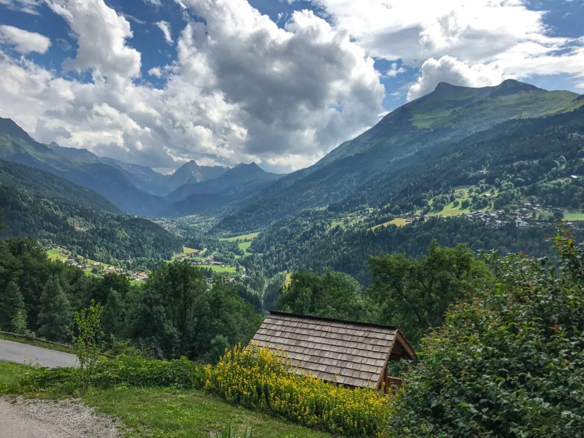
Ahead is the Montjoie Valley and once you’ve curved you’re way around the wooded hillside, you’ll be heading down towards Les Contamines, the traditional first night stop off on the TMB.
Did you know that there’s a refuge around every 5 kilometres along the Tour du Mont Blanc trail?
We walk past a couple of chalets adorned with bright cheerful geraniums and realise we’re in La Fioux. Refuge du Fioux (below) allows you to pitch your tent in their garden for 5 euros per person.

Le Champel is just one of the tiny hamlets you’ll stroll through on stage 1 (day 3 of our TMB itinerary) from Les Houches to Les Contamines
Before you can blink our legs have stomped on past and we’re en route to Le Crozat, what looks like a gathering of farm buildings and a junction of paths.
Read our post
Tour du Mont Blanc Refuges – the Good, the Bad and the Ugly
A signpost next to the Le Crozat parking shares it’s altitude with us, 1420m and gives us options to turn left up to the Refuge de Bionnassay, perched up high at the foot of the Bionnassay Glacier. It’s not our route today, but I take note of it for another hiking adventure in the future.
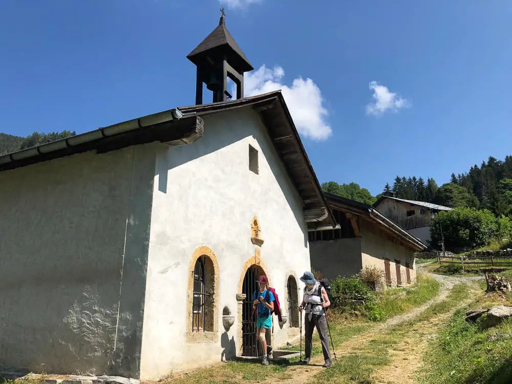
We carry on following the sign towards Bionnassay and before long (2 hr from the start of the hike from the top of the Bellevue Plateau) we reach the small hamlet. Follow the signs to Le Champel. We pass a tiny church with bars on the window, which was sadly locked up so we couldn’t glimpse inside.
Did you know Mont Blanc is “owned” by both France and Italy under a bilateral agreement and is called Monte Bianco in Italy ….
Shortcuts via public transport on the Tour du Mont Blanc
At first I was intent on putting the miles under us, wary of how long the trail ahead was and hoping to get some miles under us while our legs were still fresh. Think again. A ten minute break here in the shade was much needed. Our swollen, hot feet, refreshed were revived ten fold!
From here it’s a steep uphill for ten minutes upon where you’ll hit a main track traversing the mountain side at L’Ormey (1290m).
Did you know the snow left on the trail in summer is called névé. Névé is granular snow accumulated on high mountains that has been partially melted, re-frozen and compacted
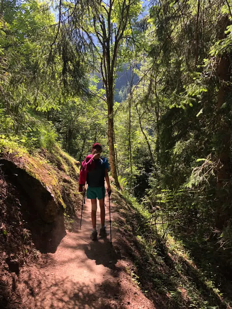
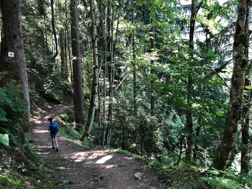
The route is pleasant under the trees. This stage is all quite gentle downhill (if you’ve of course taken the Bellevue cable car up!).
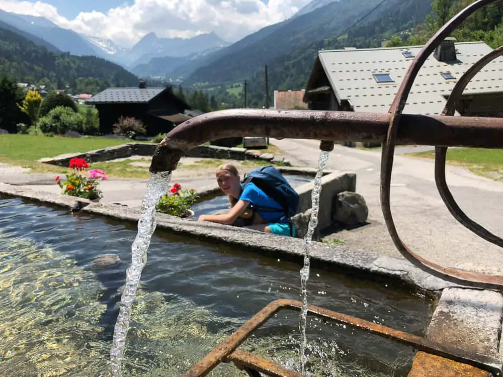
This part of the TMB gently meanders through alpine meadows and charming French villages complete with obligatory water troughs, which are all drinkable and perfect for filling up your water bottles.
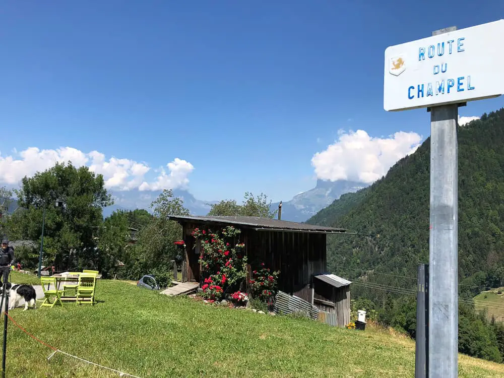
Arriving in Champel, another quiet hamlet. There seemed to be one place to stay here and perhaps eat but as we’d packed our picnic for day 1, we pressed on after taking a photo of this cute little cabin. We’d definitely recommend packing a picnic the first day.
Food en route can really add up and although it’s necessary to buy packed lunches from the refuges or eat in refuges along the route, for the first day it’s easy to bring a packed lunch.
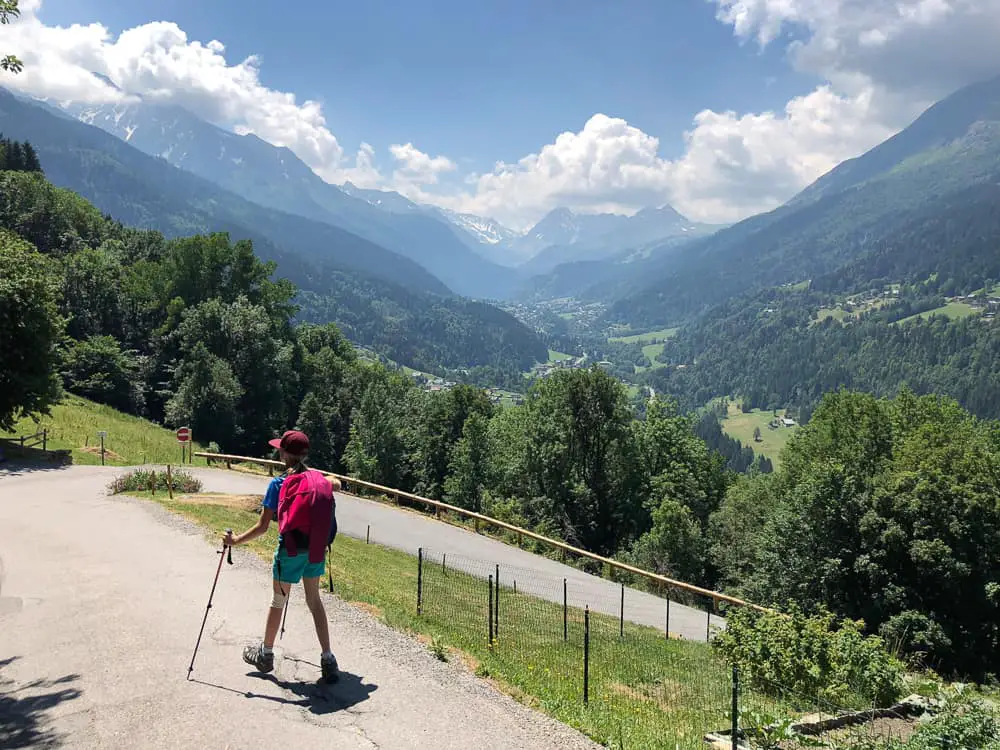
Make sure you take in the beauty of the entire Montjoie Valley ahead of you as in these few brief minutes as you round this hairpin bend coming out of Champel, for it’s the only time you’ll see the valley from this birds eye angle.
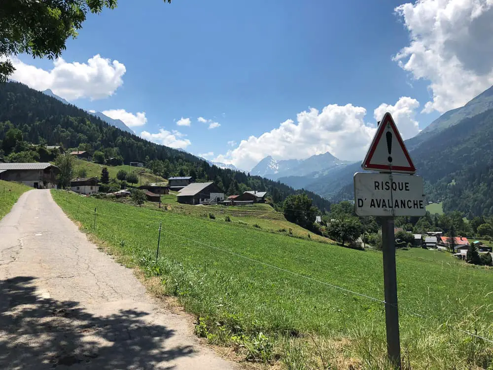
Incredibly you can see the Col du Bonhomme right at the end of the valley covered in snow. You’ll be climbing that Col tomorrow when the trail suddenly gets serious. Gone are the charming villages, replaced by exposed high mountain bluffs and pure alpine wilderness.
The trail crosses a field and disappears into the trees. There’s a signpost which is clearly marked to La Villette.
Did you know you need to have a sleeping bag liner to stay in the TMB refuges?
Read our RAB silk sleeping bag liner review
Fifty minutes after leaving tiny Champel, La Villette, a large collection of charming wooden chalets, will appear.
With the verdant Monjoie valley ahead, you will be skirting the mountainside to the left along a trail that will take you almost to Les Contamines before dropping down next to the main road that winds through the valley. It’s here that we suggest you pick up the public bus and save your legs. The bus will save you a one hour trek into Les Contamines and if, like us, you’ve booked into the Nant Borrant refuge, you’ll need that energy to deal with the long, steep climb up to the refuge.
All the hamlets we passed through were extremely quiet. We hardly saw a soul apart from other TMB hikers.
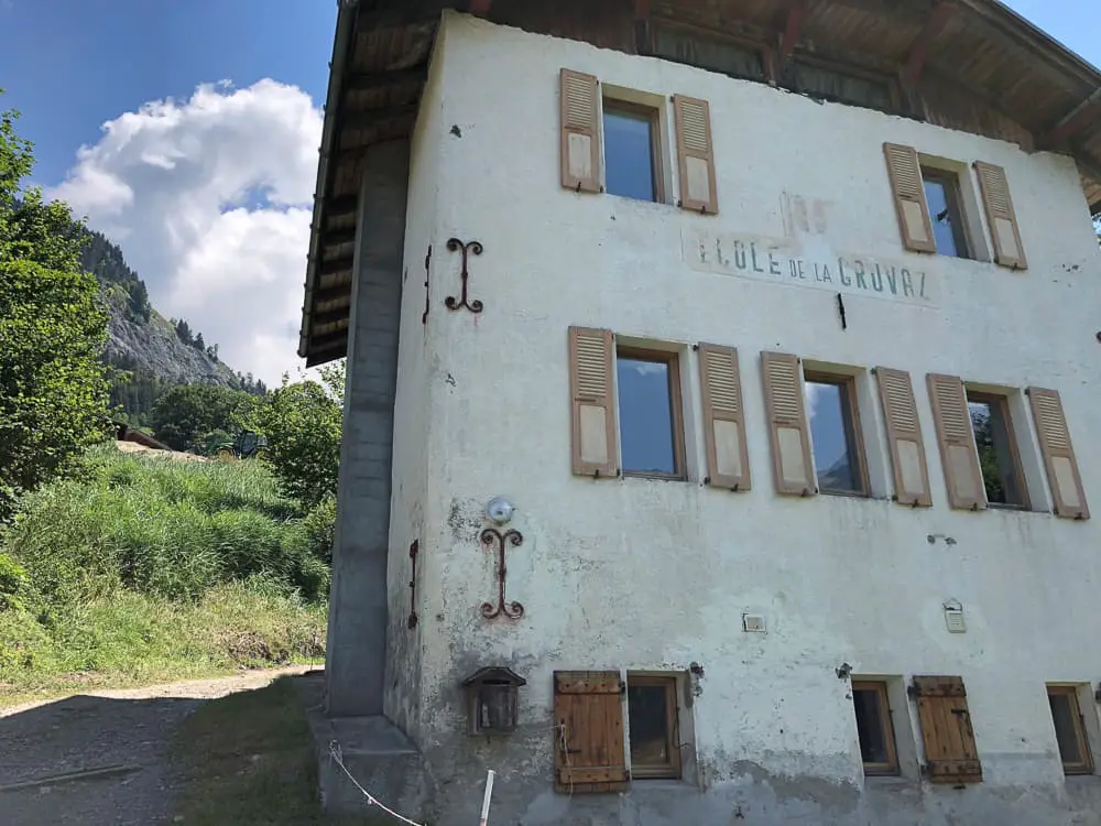
The trail from La Villette takes you onto La Gruvaz and when you arrive at the old building of Ecole de la Gruvaz, your heart will sink as your faced with an uphill climb.
It’s a 20 minute gentle descent through the shady woodland to the hamlet of La Tresse where the trail meets the main road.
The bus would whisk us in 15 minutes up to Les Contamines and straight onto the Gorge du Notre Name where the TMB trail continues, cutting out 5.8km of hiking. The trail from here to Les Contamines is not really note worthy (we know because we made a mistake with the bus and actually ended up having to hike the trail in the end).
We waited for the bus at La Tresse for some time. Several buses went past us without stopping and we were confused as the bus timetable on the bus stop clearly showed a bus was due. Resting in the shade of the bus shelter was a welcome break but after over an hour of no bus arriving, we were finally forced to lug on our backpacks once more and reluctantly took up the TMB trail again. The trail avoids the main road, cutting between the woodland on the far side of the valley and is not very note worthy at all.
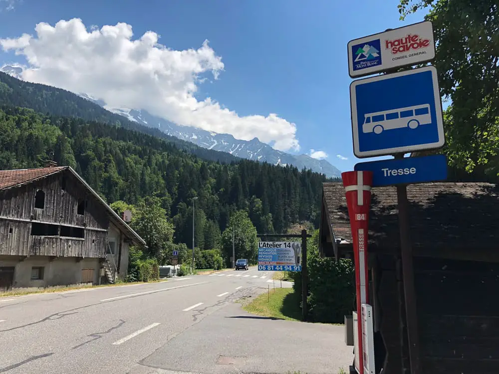
It turns out, the bus drives in a loop most of the day from Notre Dame de la Gorge to La Chapelle, only dropping down to La Tresse a couple of times a day. It turns out that the wrong timetable had been put up at La Tresse by the tourist office. So if you want to catch this bus (and we recommend you totally should hiking with kids), walk up the main road to the next bus stop – La Chapelle to catch the bus.
If you’ve caught the bus from La Chapelle, then this should be the same one that will take you to Gorge du Notre Dame. If you’re already in Les Contamines, the free shuttle bus goes every half an hour from outside the Tourist Office to Gorge du Notre Dame, which is the end of the road and where the TMB route starts again. You can read more about this shuttle bus and all our short cuts on public transport in our post here.
The bus will pull into a large car park where you’ll see a beautiful, ornate church. Note: there’s a good water trough to fill up in front of the church.
Cross the bridge spanning the river and turn right to begin the uphill one hour slog up to Refuge Nant Borrant.
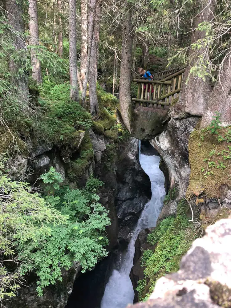
Look out for the sign post for the Pont Naturel on the right hand side. It’s a natural arch with the fast waters of the gorge rushing through and worth a couple of minutes stop to check it out.
Shortly after this, you’ll come to a perfect little Roman bridge, the Pont de la Téna, spanning the gorge with great views of the long vertical drop into the chasm below. There’s a good viewing platform along the opposite side.
What a welcoming site it is to see this chocolate box chalet in the distance welcoming you with colourful geraniums spilling out from window boxes.
Refuge Nant Borrant is run by friendly Patricia and Pierre. This cosy refuge with five small dorms of between 5-9 beds, comes with rave reviews on Trip Advisor. We paid €43 per adult and €30 for a child for half pension (dinner, bed and breakfast).
You can book online easily on their website http://www.refuge-nantborrant.com.
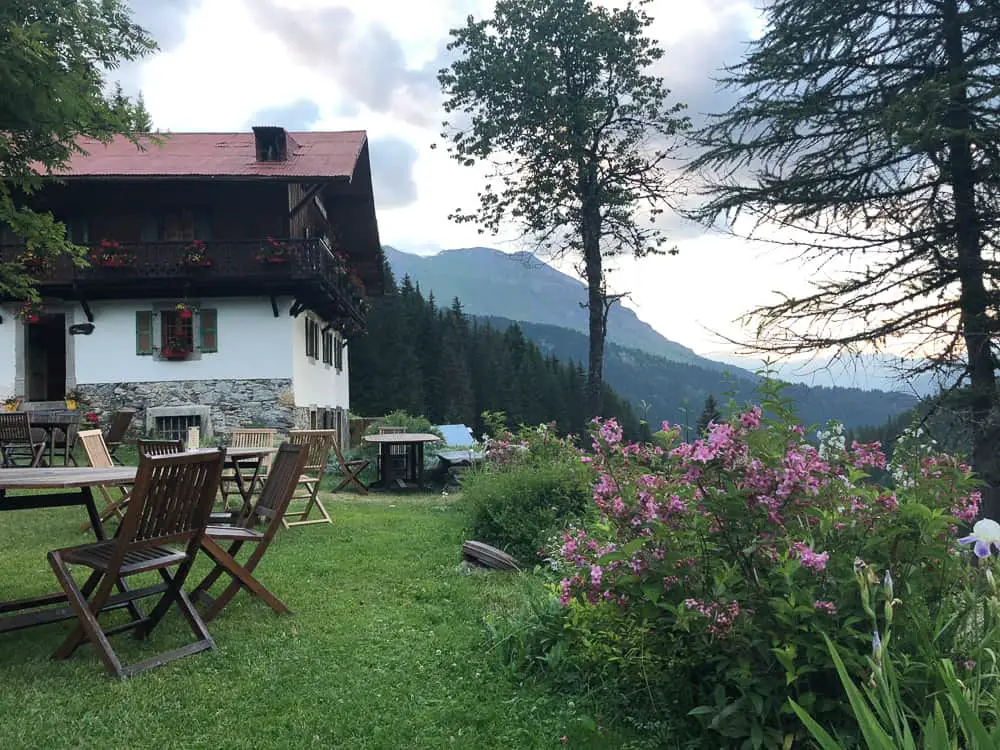
The warm, welcoming ambience of Nant Borrant was embracing after our long day on the trail. The hearty, delicious food (vegetable soup, beef stew and apple pie) polished down in no time at all. The smaller dorms are the perfect size for families (one with 5 beds and one with 6) and there was no problem with me specifically asking for one fo the smaller dorms when booking.
It’s a great feeling to be an hour up on the next day’s hike and in hindsight I don’t know how we would have completed the next day without our insight to book at Nant Borrant.
Did you know you need to sleep in a sleeping bag liner in the TMB refuges? You can usually hire one for around €3 but we’d recommend taking your own.
We wriggle into our sleeping bag liners (we highly recommend the ultra light RAB silk sleeping bag liner ) and fall into our comfy beds with a mixture of excitement and trepidation of the trail ahead. Popping in our ear plugs (an absolute must in refuges) we are soon dozing contentedly.
Related TMB content
Read day 1 (stage 10) Tré-le-Champ to La Flégère
Read day 2 (stage 11) La Flégère to Les Houches
Read day 3 (stage 1) Les Houches to Les Contamines (& onto Nant Borrant refuge)
Read day 4 (stage 2) Nant Borrant Refuge to Les Chapieux
Read day 5 (stage 3) Les Chapieux to Refugio Elisabetta
Read day 6 – Tour du Mont Blanc – Stage 4 – Rifugio Elisabetta to Courmayeur
Ultimate guide to your self guided Tour du Mont Blanc
Tour du Mont Blanc Refuges – the good, the bad & the ugly
Tour du Mont Blanc Difficulty? Transport options on the TMB
Day 2 – Hiking Tour du Mont Blanc – Stage 11 La Flégère to Les Houches
Day 4 – tour du mont blanc itinerary stage 2 – nant borrant to les chapieux, you may also like, nz – hiking the abel tasman trail with..., 9 easy restaurants for families in chamonix, the ultimate self guided tour du mont blanc..., step into the void – a glass box..., holidays in south west france – what to..., best trekking poles for women review: black diamond..., the perfect starter family bike tour – la..., climbing mount kinabalu tips – bag your first..., the panoramic mont blanc cable car in chamonix..., 6 day tour du mont blanc itinerary (half..., day 2 – hiking tour du mont blanc..., day 1 – trek mont blanc – stage..., tour du mont blanc blog – stage 8..., tour du mont blanc stage 6 refuge bonatti..., tour du mont blanc self guided: stage 5..., day 6 – tour du mont blanc trek..., day 5 – tour du mont blanc hike..., day 4 – tour du mont blanc itinerary....
Awesome picture’s, and description of your travels.Can you please tell me if the are trail head parking for these parts of the TMB? I am looking for some loop trails and up and back trail for hiking this summer, end of July thru August 2019. My oldest sister will travel with us in HAUTE SAVOIE, SAVOIE REGION of France, so we’re looking for ideas on Easy to Moderate trails in difficulty. Villaz will be our base camp, and we will drive each day for hiking. Total round trip time for hikes can be as long as 5 or 6 hours, as we will pack our lunch and snacks. Thank you ! Allan Ray Parmley, Lyon France .
Hi Allan. Some of the TMB sections have parking but not all have trail loops. For example there is a large car park on the Col des Montets pass in France, near the Swiss border, where you can start Stage 10 (anti-clockwise) Tré-le-Champ to Refuge de la Flégère. Note that this refuge and the Lac Blanc refuge are closed for this summer, but walking up to Lac Blanc is a wonderful hike with incredible views. You could walk a loop around if you took the normal route (via the ladders) up to Lac Blanc and return the alternative route back to Col du Montets. The alternative route is for those who have an aversion to heights and so want to avoid the ladders. Have a look at the ladders on my dedicated post here https://thefamilyfreestylers.com/tour-du-mont-blanc-difficulty-ladders/ to see whether you fancy that route or not. If you feel you are able to tackle the ladders then this is a lovely 5-6 hour route.
I don’t know Villaz personally but I am sure there are some lovely walking routes around there. Good luck. Happy hiking
My mum and I are gonna home Les Houches to Courmayeur and hoping to do it in three days and stay at maison vieille on the last day. I’ve read your post but the refuge u stayed in after walking from Les Houches is full… can u recommend another one maybe a bit further so we can do it all on three days…? Been googling but getting confused..
Hi Amanada.
We stayed in Nant Borrant which is the first refuge after Les Contamines. If that’s full, you have two options, staying in the town of Les Contamines (which is what most trekkers do). We only walked up to Nant Borrant as we wanted to cut out an hour of day 2 which is pretty hard with two cols to climb. If you want to press on the trail further, it would be best to try to book into the next refuge – Refuge de la Balme. We didn’t stay there and we had heard it’s not one of the best refuges but location wise, it’s perfect. It’s about an hour past Nant Borrant.
If you really only have three days I would advise you to miss the Les Houches to Les Contamines stage and start at Les Contamines. Squeezing the entire Les Houches to Courmayeur into 3 days is pretty tough and I’m not sure you’d have any time to actually enjoy the route. You’d be putting in long hard days (and the days are already long and hard doing it in 4 days!). Les Contamines to Courmayeur is the most spectacular scenery so missing out the meadows, farms and rolling countryside between Les Houches and Les Contamines is no real biggy.
Hi Mags Firstly, I just want to say how terrific the Family Freestylers is. So informative and inspiring. Thanks for sharing such great information and photos with the rest of us. I would love your advice about trekking in France with my family next July. There are 6 of us, including four kids aged 10, 13, 14 and 16. We are an Australian farming family so we’re accustomed to being outdoors and we’re all pretty fit but the kids aren’t experienced multi-day walkers. I had hoped to do a 5-7 day walk in the Mount Blanc region but I’m concerned that the 7-10 hours of walking per day may turn the kids off trekking for life! I want them to love it and to experience the euphoria of mountain walking. I have always loved the independence of walking self-guided, and this is also a better option for us from a cost point of view. Can you recommend a fabulous 4-7 day walk in the French Alps through magnificent scenery, with accommodation en route? Thanks so much for your help. (I don’t know the Alps at all, and it’s difficult to work out what’s best from internet. Your information stands out!) Rosie
Hi Rosie. Great to hear from you and thank you for your kind words! I think a section of the Tour du Mont Blanc would work really well for you guys. I would trek from Les Contamines to either Lac Combale or to Courmayeur. These TMB days are certainly the most adventurous and striking mountain scenery. I agree hiking such long days isn’t so much fun for kids and actually in hindsight, I would have cut our days down a bit had I known it would have taken us so long – it was difficult to plan ahead with the information I had on the internet at the time …. which is why I decided to write so much about it after we came back 🙂
I helped a friend of mine plan her trip with her young children (5, 9 and 11 and it worked really well. I would suggest starting in Les Contamines instead of Chamonix, as this section is long and not particularly striking.
Day 1 – Base yourself in Chamonix for stunning alpine scenery. Leave your baggage at your hotel while you trek 3-4 days on the TMB. Catch a taxi to Les Contamines from Chamonix rather than taking the bus (it takes a fair few hours with connections so it’s a bit of a pain) Stay the night in Les Contamines.
Day 2 – hike from Les Contamines and stop the first night at the Refuge du Col du Bonhomme. Now this refuge is the only down side of this shorter stage itinerary. It ISNT the best refuge on the trail by a mile – in fact it’s super basic and the food is awful (I’m not selling it am I! 🙂 ) but from a location point of view it’s the perfect stop time wise. It’s a rough HUGE basic refuge, it’s super exposed and at high altitude but if you book a private room, instead of a dorm, and be prepared that the food is going to be awful (there’s also no electricity at night so expect candle night dinner) and see it as an adventure then you will be fine.
Day 3 hike from Refuge de la Col du Bonhomme to Refuge Mottets (just past the hamlet of Les Chapieux) – it’s newly converted and has excellent facilities and food! Yay.
Day 4 hike from Refuge Mottets over the Col de la Seigne into Italy. Stay the night at Refugio Cabane Combale (Italy) – this is lovely refuge with ensuite rooms and good food.
Day 5 Then you can decide to hike to Courmayeur (it’s quite a long stretch) or take the bus from near Cabane Combale (50 min walk to the village of Visaille) where you can catch a bus to Courmayeur. Stay here the night and then catch the bus back through the Mont Blanc tunnel to Chamonix OR if the weather conditions are good – catch the Skyway/Helbronner/Chamonix cable cars back over to Chamonix. This is expensive but incredible – often closed due to wind.
I would advise you to buy the Trekking the TMB book by Kev Reynolds. This will allow you to look at the route and learn about the stages between the refuges I’ve suggested. If you have any other questions on this route, please feel free to contact me. Cheers. Mags
You are a gem, Mags. Thanks so much for your advice. I’ll look at the route you suggest and come back with any further questions. Keep adventuring and inspiring us to do the same.
You’re welcome Rosie! Give me a shout if you have any questions 🙂
Hello, thank you for your detailed description, I used it to plan our TMB trek and it was so helpful!!! Again, thanks to you, everything went so well!!!
Leave a Comment Cancel Reply
Save my name, email, and website in this browser for the next time I comment.
Don't subscribe All new comments Replies to my comments Send me an email with any followup comments. You can also subscribe without commenting so you can read replies as they come in.
Our website uses cookies. You can choose to opt out if you prefer to Yes that's fine Read More
- GR54 Tour de l’Oisans et des Ecrins
- Randonnées Chamonix
- Randonnées Chatel
- Randonnées La Clusaz
- Randonnées Morzine Avoriaz
- Randonnées en Ardèche
- Randonnées Dolomites
- Randonnées dans l’Esterel
- Randonnées dans le Massif Central
- Randonnées dans le Mercantour
- Randonnées Jura
- Randonnées dans les Pyrénées
- Randonnées Vosges
- Tour du Mont Blanc
- Tests Matos
- A propos de nous

ETAPE 1 : TOUR DU MONT BLANC : HOUCHES – CONTAMINES MONTJOIE
Montagne Trekking vous propose de vous détailler l’ensemble du GR Tour du Mont Blanc. Voici la 1ere étape qui commence au parking des Houches en passant par le col de Voza, puis par la reserve naturelle des Contamines Montjoie, pour arriver à l’air de bivouac au pont de la Rollaz. Cette 1ere étape est assez difficile en terme de dénivelés et de kilomètres.
Afin de vous guider au mieux, chacune de nos randonnées est décrite dans les moindres détails, vous ne pourrez donc plus vous perdre.
Les règles à suivre pendant votre marche : Bien suivre le balisage. Pour éviter de vous perdre et de prendre des risques inconsidérés, suivez le balisage qui jalonne chaque parcours de randonnée pédestre. Soyez toujours prudent et prévoyant lors de votre randonnée. Montagne Trekking ne pourra pas être tenu responsable en cas d’accident ou de désagrément quelconque survenu sur ce circuit. Il vous appartient aussi, au préalable, de vérifier que votre condition physique et le matériel que vous possédez permettent d’effectuer cette randonnée.
INFOS PRATIQUES

ETAPE 1 : TOUR DU MONT BLANC : HOUCHES – COL DE VOZA – CONTAMINES MONTJOIE
La carte du parcours, l’itinéraire en détails.
LE PARCOURS (PHOTOS EN DÉTAILS )

LES PRÉVISIONS MÉTÉOS POUR VOTRE RANDONNÉE
Points d’intérêts de la randonnée, 1/ les contamines montjoie.
Les Contamines Montjoie est une formidable galerie de portraits. Tous les milieux et paysages y sont représentés : barres rocheuses, éboulis, landes et pelouses alpines, lacs d’altitude, glaciers ainsi qu’une forêt particulièrement riche et dense.
Le village est ceinturé de sommets qui participent à la renommée des Contamines : les Dômes de Miage, le Mont Joly et le Col du Bonhomme.
Du village à 1000 mètres d’altitude, jusqu’au point culminant à 3900 mètres, le site est remarquable par l’étagement de tous les milieux naturels. Cette singularité permet la vie d’une faune et d’une flore riches et variées selon les altitudes.
Les deux tiers de la commune des Contamines Montjoie sont classés « Réserve Naturelle de France ».
2/ Le Col de Voza
Le Col de Voza se trouve à l’ouest du massif du Mont Blanc, entre l’Arve et le Bonn Nant. Il est entouré par la Tête de la Charme et le replat de Bellevue. Plusieurs randonnées mythiques tel que le GR5 et le GR Tour du Mont Blanc aboutissent au Col de Voza.
Vous pouvez également retrouver nos parcours de randonnée sur Facebook et Instagram !!
Retrouvez nos autres Randonnées ici !!!
Autres randonnées a faire sur Chamonix
Randonnée le lac blanc et lacs de cheserys depuis la flégère, le brévent par le téléphérique du brévent, de flégère à planpraz : grand balcon sud, randonnée du refuge de lognan vers le glacier d’argentière, du brévent au houches, derniers articles, tour du roc de chère, porte bébé en randonnée : comment bien le choisir , les meilleures tentes de trekking, les meilleures tentes ultra légères pour 2 places, 1 commentaire.
Cool ce parcours en photo ! Très bonne idée de mettre du visuel (il ny a pas une inversion entre alt max et min dans l entête ?)
LAISSER UN COMMENTAIRE Annuler la réponse
Enregistrer mon nom, email et site web dans ce navigateur pour la prochaine fois que je commenterai.
© Copyright - Montagne Trekking
- Circuits de randonnée
- Conseils rando
TMB Day 1: Les Houches to Les Contamines
by Melanie McManus | Jun 28, 2022 | By Location , Europe , France , Hiking , Tour du Mont Blanc 2022 , Trail Journals

The first part of the route wound through town. There’s a decorative archway proclaiming the TMB in one spot, and lots of hikers – including us – posed underneath it for photos. We walked more than a mile (2 km) through town before the route left the roads and went up into the woods. We actually missed our turn, as the trail sign was at a lower level than the previous TMB signs, so it didn’t catch our eyes. Oh, well.
Disclosure: This post contains affiliate links (among regular links) to products I own and like, or which I think you might like. This means that, at no extra cost to you, I will earn a commission if you click through and make a purchase.
There were a fair number of hikers out on the trail, even though the busiest season isn’t until July-August. I can’t imagine hiking it with many more people. I don’t like big crowds.

Leaving Les Houches Far Behind
When it was about time for a snack break, we fortuitously came upon a mountainside restaurant. Perfect! We had a beer, even though it was only about 10 a.m., and took lots of photos of the mountains, as the sun began to peek out – yes!
From that remote mountainside stop, the trail returned to a mix of traditional trail and asphalt paths/streets winding through some very cute towns with Swiss-style architecture. Near the end of the day it began to drizzle, but it wasn’t bad at all. There were rumbles of thunder up in the mountains, but it never stormed.

Life is good!
Tour du Mont Blanc Miles Today: 11.2 (18 km) TMB Miles Overall: 11.2 (18 km) TMB Miles to Go: =98.8 (159 km)
Most useful hiking gear today: Definitely my Black Diamond Carbon Z trekking poles and my new (!) Keen Nxis hiking shoes . Comfy and supportive.
©2018 Melanie McManus – All Rights Reserved

- Hiking Features
- Family Holidays
- Ireland Day Hikes
- Lugnaquilla– Co Wicklow Highest Point
- Brandon Hill Kilkenny highest point
- Arderin Offaly and Laois highest point
- Galtymore and Galtybeg High points
- Knockmealdown-Waterfords highest point
- Cornhill–Longfords Highest Point
- Slieve Foye — County Louth highest Point
- Kippure- Dublins Highest Point
- Mount Leinster–County High Point Wexford & Carlow
- Mount Errigal Donegal- County Donegal Highest Point
- Sawel Mountain- County Derry and Tyrone highest point
- Trostan– County Antrim Highest Point
- Cuilcagh Cavan and Fermanagh Highest mountain
- Slieve Donard– Co Down Highest Point
- Slieve Gullion– Co Armagh Highest point
- Moylussa — Co Clare Highest Point
- Knockboy- County Cork highest point
- Seltannasaggart East Slope– County Roscommon Highest Point
- Truskmore — County Sligo & Leitrims Highest Point
- Tour du mont blanc Day 2- Les Contamines to Les Chapieux
- Day 3 TMB — les Chapieux to Rifugio Maison Vielle
- Day 4 TMB — Rifugio Maison Vielle to Rifugio Bonatti
- Tour of Mont Blanc Day 5— Rifugio Bonatti to La Fouly
- Mont Blanc Trail-Day 7 TMB – Champex to Trient
- Day 8 TMB — Trient to Tré le Champ
- Day 9 TMB-Tré le Champ to Plan Praz
- Day 10 TMB-Le Brevent to Les Houches
- Top Hiking Guide Book Reviews 2022
- Hiking with a baby and toddler Ireland
- Tips for hiking with a baby
- Camino De Santiago
Tour du Mont Blanc day 1-La Houches to Les Contamines

Tour du Mont Blanc Day 1 La Houches to Les Contamines
On Tour du mont blanc day 1 we got a taxi from Chamonix to Les Houches, which sits at an elevation of 1004m. We started walking at the (Start of the TMB) tourist office and got as far as a road underpass, which our guidebook suggested us to go underneath but some old lady hanging out of a window decided to send us the scenic route. But she neglected to tell us that stage was unbelievably steep and probably put 2 hours on our journey. To be fair to her, we loved this section and it was well worth the pain, as the views were fantastic. As we did get lost on the first stage of the hike and we were getting a tiny bit worried, the guidebook was in the below position until we found the first couple of TMB signposts.

On most stages of the Tour du Mont Blanc, there are generally 2 options, a higher route, and a lower route. The lower route is usually much easier, we accidentally went on the higher route today, which is not walked much. The trail was slightly overgrown but it felt amazing to be walking through the overgrown field trails filled with wildflowers in the meadows.

The trail was breathtaking and it such a shame most of the hiker’s missed these amazing views and climbs.

We eventually came out of the woodland and meadows to be greeted by the base of a ski slope, when we got to the top of the ski slope there was a much-needed coffee shop.

We filled up with water and coffee before we even attempted to climb to the top of Tricot, which sits at an altitude of 2120m. After our coffee, we started back on the trail. Which starts again by cutting through another wood section until we reach a train track, which we coss cautiously. We continued walking through the wood until we meet a glacier river on the side of the mountain. We had to cross the raging icy cold river by a very shaky rope bridge, I didn’t think I’d ever say that sentence in my lifetime.

The trail climbed rapidly after the rope bridge for about an hour to the top of Col de Tricot. This was our first real experience of seeing Mont Blanc and it’s glaciers closely and it did not disappoint, WOW, what a mountain. At the top of the Col, we had some over-friendly sheep, one became very interested in my GoPro and tried to bite it, we laughed at this for days after.

Col du Tricot is the highest point of the day and when we reached the top, the wind became very cold. We didn’t stay here too long and started our decent immediately after the sheep was finished trying to get their free meal.

There was an amazing view of the valley below the Col, the zig-zag trails going down the side of the mountain were in good condition but they were extremely steep. I can only imagine walking up the zig-zag trail side of the mountain would be extremely difficult, physically and mentally. We were very happy to eventually start walking downhill, especially after walking all morning uphill but we didn’t look at our guidebook correctly and assumed that the lower valley in the above picture would be where we would be staying the night, we were wrong!!! In the above picture, you can see another hill parallel to the mountain, the trail climbs this hill and descends into the valley on the opposite side.

The valley is full of old farm buildings with wonderful natural slate stone roofs, which are just not built like this anymore. There were refugees and a coffee shop in this valley, we treated ourselves to some blueberry pie and coffee. At this stage of the hike, the day was starting to get on and we still had 2-3 hours walking before we got to the next refugee. We ate the pie and drank our coffee quickly as we needed to get moving as quickly as we could.

We walked the next hill reasonably quick and walked along the top which had another refugee that was surrounded by cows with the large bells around their neck. We could hear the bells first before we could see all the cows, they were a welcome distraction.

After passing the small refugee we started walking downhill through a wooded area, this then turns into a windy steep road leading down through some alpine homes and some very friendly donkeys.

We then walked into Les Contamines and paid the local tourist office a visit to get a list of all accommodation in the area. The tourist office recommended Camping du Pontet for the nights stay. We then continued along the TMB trail, by following the river towards the hills. The campsite will be on the right-hand side on the other side of the river.
Camping du Pontet is about 10-minute walk out of the town but I suppose that depends on how tired your legs are at this stage. The campsite had a large building with a communal kitchen, a shared toilet, a shower area and two dorm rooms spread over 2 floors.

When we got to the Refugee, we refuelled with some lovely French beer and then went for our showers.

The Refugee was very clean with good size beds and friendly staff. The refugee cost €15 each for the night’s bed and breakfast. It was an additional €15 for a three-course meal in the campsite restaurant and an additional €7.50 for a packed lunch that consisted of a salad roll, an egg, a pack of crisps and a chocolate bar (we recommend getting this packed lunch).

Our first day’s impression of Tour du Mont Blanc
I’m not too sure what I was expecting from this mountainous adventure, as the highest I’d ever hiked in Ireland was just over 1000m high and on our first days hiking in the Alps we doubled this height. We probably weren’t ready for the sheer vertical hill walking but we tried to prepare for it with lots of walking for months beforehand and after the first hour, we found our rhythm fairly quickly.
The cost of food in the coffee shops was slightly more expensive than we had expected, it was a similar price to an Irish city price, the Camino hiking that we previously did probably spoiled us with all the cheap quality food before this.
Walking advice for Day 1 of Tour du Mont Blanc
- Buy a good guide book, there are loads of signs everywhere but a good Tour du Mont Blanc guidebook is always handy for reassurance when you think you might be lost.
- Bring suncream, as the sun gets very hot in summer.
- Bring a Poncho and layers of clothes, the weather can change quickly.
- There are many Refugees to buy coffee and water but bring enough water to last 4-5 hours.
Walking time to Camping du Pontet on Tour du Mont Blanc
- You would want to allow 8 hours including breaks.
- We started walking out of La Houches at 8:20 am and we arrived at the church in Les Contamines at 4:20 pm.
The budget for Tour of Mont Blanc Day 1
- Lunch cost us €18 each for coffee, a sandwich, and a few snacks.
- €15 each for the night’s bed and breakfast in the Refugee
- €15 for a three-course meal in the campsite restaurant and an additional €7.50 for a packed lunch
TMB day 1 Map
See full screen
Tour du Mont Blanc day 1 PDF Map
Short instagram video of day 1 tmb hike.
View this post on Instagram A post shared by Gina ~ Mammy Hiker 🤱👭 (@ourlittlehiker)
Privacy Overview
WORLD WANDERING KIWI
MAKING THE PAGES OF THE ATLAS REAL: A TRAVEL BLOG

The Tour du Mont Blanc: Les Contamines to Les Houches
I set out on my final day on the Tour du Mont Blanc long distance hike with joy in my heart. On yet another stunning day, I chose the easier of the two variants leading from Les Contamines to Les Houches has two variants.
This turned out to be a great choice as mid-morning I bumped into a couple of Israelis I had chatted to a few days previously and it was lovely to have their company for a few hours and enjoy a picnic together.

I started in the fresh morning from the exquisite church of Les Contamines and the day warmed up very quickly. With the hot weather this hike from Les Contamines to Les Houches felt strenuous enough for my tired legs. There was a terrible snorer in the Les Contamines CAP Refuge so I hadn’t had the best night’s rest. It was nice to have some dappled shade as the trail climbed through the woods.

Today was a lot about chocolate box villages and hamlets, where every chalet is perfectly decorated and foaming with bright flowers. Indeed, walking down into the Chamonix valley was an exercise in trying to decide which of the gorgeous chalets should be my ski/hike holiday chalet if I were to win the lottery.

This was also a day for domesticated animals, including these gorgeous donkeys.

At the same time there was no lack of stupendous mountain views. From the hamlet of Bionnassay the shining snows of the Aiguilles de Bionnassay and de Gouter, including the impressive Bionassay glacier are mesmerising and kept me going up, up the track through flowering meadows to the Col de Voza.

There I experienced the surprise of seeing the 100-year-old Tramway du Mont Blanc trundling into one of its highest stations. The Tramway du Mont Blanc runs from St Gervais le Fayet down in the valley all the way up to the Nid d’Aigle at 2,372 m (7,782 ft), making it the highest tramway in France and the fourth highest in Europe.

Watching the vintage trains come and go, carrying sightseers made for an interesting picnic spot. There is also a café here and a large hotel.

Descending from the Col it is all about the sweeping line of the Chamonix Aiguilles. Far below Chamonix and its sprawl look like a toy town. The path returns to the ski tows now.
One especially interesting thing that came out of meeting the Israelis was that they were tracking their hike on a GPS and were able to report that every day the actual distance covered was significantly higher than the distance mentioned in the Tour du Mt Blanc guide book. So for this day from Les Contamines to Les Houches the guidebook says 16 kilometres but the GPS said it was more like 24 kilometres. This seems to indicate that the distance in the guide book is simply an estimate based on the map.
Enjoying a cold beverage at a café in Les Houches, I felt totally elated at my achievement, which, as some of you know had been much delayed. Strangely, I found walking along the flat footpaths of Les Houches quite uncomfortable. The muscles in my legs didn’t seem to know how to behave with a flat track!
I hope you have enjoyed following me on my way around the Tour du Mont Blanc. Below are links to each of the 11 stages on the TMB and I hope my words and photos inspire you to do the TMB also. You’ll find information on planning, training, booking accommodation on the Tour du Mt Blanc , as well as a TMB gear list and much more… As I have said before, there are many ways to do this long-distance alpine route and it is so well set up it is really accessible to everyone.
By Natasha von Geldern
Here is my day by day account of hiking the TMB:
Tips for hiking the Tour du Mt Blanc
Hiking the Tour du Mt Blanc: Les Houches to La Flegere
Hiking the Tour du Mt Blanc: La Flegere to Tre le Champ
Hiking the Tour du Mt Blanc: Tre le Champ to Triente
Hiking the Tour du Mt Blanc: Triente to Champex
Hiking the Tour du Mt Blanc: Champex to Ferret
Hiking the Tour du Mt Blanc: Ferret to Rifugio Bonatti
Hiking the Tour du Mt Blanc: Bonatti to Courmayeur
Hiking the Tour du Mt Blanc: Courmayeur to Rifugio Elisabetta
Hiking the Tour du Mt Blanc: Elisabetta to Refuge de la Croix du Bonhomme
Hiking the Tour du Mt Blanc: Croix du Bonhomme to Les Contamines
If you liked this post on hiking the Tour du Mt Blanc why not pin it?!

By Natasha von Geldern on March 15, 2019 .

on your hiking packing list… there were x’s in some spots and not others… did you not bring all those items? Also, we are going to bring a tent and sleeping bags.. would you say finding tent camping was relatively easy?

Hi Carly, I didn’t see anyone camping on the TMB when I did it but I think it is possible in places. I would recommend carrying as little as possible, it makes life more fun on the trail 🙂 The x’s are just me ticking items off as I put them in my bag – I definitely took all of these things. Have a great trip!!!
Thank you for your clarification on the packing list :). I just saw this. I have read a few blogs about tent camping so I know it has been done – we will just have to go with the flow! I am nervous about the extra weight to tent camp the majority of the time but I also was overwhelmed with committing to lodging ahead of time. Either way, my husband and I are excited for our own TMB journey!
It is hard to find a balance between flexibility and commitment sometimes! I hope you have a wonderful time!
Leave a Reply Cancel reply
This site uses Akismet to reduce spam. Learn how your comment data is processed .

Natasha von Geldern
Hi I'm the Wandering Kiwi, a travel writer and blogger passionate about making the pages of the atlas real. I have travelled in over 50 countries and hope my tales inspire you to live your travel dreams!
View Full Profile →
DISCOVER TRAVEL IDEAS
Trending today.

TRAVEL INSPIRATION
- Financial Protection
- Tel: +44 1273 256753
Les Contamines
Located at the far western end of the Mont Blanc massif, Les Contamines (1160m) is a beautiful and quiet village that retains its quintessentially French character. When hiking on the Tour du Mont Blanc you will spend at least one or two nights here.
In the centre of the village there is an impressive church and the shops, bars and restaurants line the single road that leads out of the Contamines Valley. There are very helpful staff in the tourist office, three small supermarkets, an ATM and a handful of outdoor shops selling hiking equipment. The village has an unrushed feel to it and it is worth spending time watching the world go by whilst enjoying a coffee or an ice cream.
The village stretches along the flanks of the river and there are lovely old farm buildings that have been converted into houses and some of the old chalets have been carefully restored. Although it is popular family ski resort , there are only a few hotels – most skiers stay in apartments and chalets. As such, the choice for trekkers is limited. However, you can find a couple in the centre of the village and a few more spread out along the valley and close to the ski lift system.
During the summer a few of the ski lifts are running which allows you quick and easy access to the meadows and alpages above the village. There are lots of further walking opportunities and some people try to climb Mont Joly at 2525m. This is a strenuous hike with over 1000m of ascent on steep ground, but the 360° panorama from the top is outstanding. From here you can see Mont Blanc , the Aravis mountain range , the ski resort of Megeve and the long, wide valley leading to Geneva.
Just over 3.5km from the village, there is the church of Notre Dame de la Gorge. It is a small, but beautifully decorated church and is on the Tour du Mont Blanc trail . Originally the site was known to hermits and, during the Middle Ages, the church provided shelter to travellers. Its current appearance is from 1699 when extensive renovations and repairs took place. It is a Baroque style of architecture. In addition, there are fifteen shrines that line the road as you approach the church – all of them signifying different stages of the Virgin Mary’s life. As it is directly on the TMB, you can go inside and visit: there is no charge.
Whether you are coming to Les Contamines from a clockwise or counter-clockwise direction on the Tour du Mont Blanc , both days are tough and involve long ascents to cross mountain passes. If coming from Les Chapieux (clockwise), you cross the Col du Bonhomme and then have a three-hour descent into Les Contamines, passing the Chalet de Balme and an ancient bridge that crosses the waterfalls of the Nant Borrant river. If you are going anti-clockwise it takes 4-5 hours to reach the pass. When continuing clockwise from Les Contamines towards Les Houches you have the easier route via La Gruvaz, Bionnassay and the Col de Voza or the much tougher hike over the Col du Tricot (2120m). The latter is the steepest single climb on the Tour du Mont Blanc and takes between 45 and 90 minutes to get to the top. However, you can stock up on blueberry pie at the Chalets de Miage to get you through it!
https://en.lescontamines.com/
Information
Mont blanc du tacul.
Mont Blanc du Tacul forms part of the ‘three monts’ route to the summit of Mont Blanc. It is easily accessed from the top of the Aiguille du Midi cable car, hence its popularity. There are many mountaineering routes to the summit of Mont Blanc du Tacul, but the easiest is the North-West face. Although seen as one of the classic routes to the summit of Mont Blanc, it has significant obj
Punta Baretti
Punta Baretti is 4013m high and is one of the main ridges leading up from the Val Veny on the Italian side of Mont Blanc. The mountain is much steeper on the south side, compared to slopes over-looking Chamonix on the no
In winter Lac Blanc is snow-bound and only sensibly reached on skis following an off-piste route. However, by mid to late June the snow has normally gone and the area opens up to walkers and is a must-see attraction for
Mont Brouillard
The summit is named after the French for ‘mountain of mist’. It was first climbed in 1906 by Karl Blodig, Oscar Eckensteinand and Alexis Brocherel. The peak is located on the Italian side of Mont Blanc and forms on
Dôme du Goûter
The Dôme du Goûter is not part of the Tour du Mont Blanc, but can be seen from the TMB trail. It is 4304m high and Mont Blanc is 4808m high. Only climbers or Alpinists will make their way to this peak en-route to the s
Fitness Levels Needed for the Tour Du Mont Blanc

Organiser of the Tour du Mont Blanc

Location of the Tour du Mont Blanc

Planning for the Tour du Mont Blanc

Distance on the Tour du Mont Blanc

Guides on the Tour Du Mont Blanc

Helpful Links
- Tour du Mont Blanc
- About Tour du Mont Blanc
- Guided Tour
- Self Guided Tour

TMB Day 1: Les Houches to Les Contamines
Drew Robinson | August 10, 2015 July 30, 2014 | Tour du Mont Blanc
We arrived in Les Houches around noon after taking an Alpybus shuttle from the Geneva Airport. Initially, we had planned on spending a day in Chamonix before trekking, but due to weather and the late arrival of our flight, decided we would see the beautiful mountain town at the end of the trek.
Read More Daily reports from Tour du Mont Blanc
Les Houches is a quaint little village to the east of Chamonix and the perfect starting point to begin our anti-clockwise tour of Mont Blanc. We stayed at Gite Michel Fagot for the night, which offers a a nice set of dorm rooms. We had four beds in ours, and Julia and I shared the space with two older Spanish gentlemen from Mallorca. I had done my best before this trip to learn as much French as possible, but having no one to practice with left me with the same skills as a baker in a barnyard. It was nice to speak a language I was comfortable with. English is always easy, but Spanish can be just as nice. The host of the Gite was a pleasant young woman from Belgium, with airy brown hair and freckles earned from time out on the trails. She did a great job of managing the place, considering how many beds were under her responsibility.

We spent some time walking around Les Houches and talking about what to expect in the coming days. Not too far from the church we found a great little pizza place for dinner. After dinner, we made our way back to the gite, and settled in for a restless night. We woke up early the next morning and had our first taste of a French breakfast. Breads and jams go quite well as a side dish in my book, but it took some getting used to once I realized this is all I’d be likely to have in the days ahead. Nonetheless, it was quite good when paired with a large helping of coffee.
The trail began on a wooded stairway after walking for a few hundred meters outside of the gite. The then leads though a light wooded area and passes by a few houses and roads on it’s way to the first high point, Col de Voza.

After the Col, the trail is all downhill until Les Contamines. It was a great deal of fun for us, as a trail race was taking place at the same time. Seeing runners fly by, and others hobble on, made us appreciate the leisurely pace of trekking. We reached Les Contamines not too long after noon, and found a great bed and breakfast just behind the church and off the main road. We first stopped at the Carrefour Express and bought food for dinner and breakfast. We were very happy to have our own room for the night, complete with a TV to watch the World Cup, a hot water shower, and a nice warm bed.

Share this:
- Click to share on Facebook (Opens in new window)
- Click to share on Pinterest (Opens in new window)
- Click to share on Twitter (Opens in new window)
- Click to email a link to a friend (Opens in new window)
Related Posts You Might Like
San gorgonio mountain via vivian creek and momyer creek 6 21 14, tmb day 2: les contamines to les chapieux, 12 thoughts on “tmb day 1: les houches to les contamines”.
Wow, looks amazing!!! 🙂
Thanks! This trek has been an incredible experience 🙂
What a great description of our launch!
Awesome!! What is the name of this bed and breakfast?
Thanks! It’s called Gai Soleil Chalet Hotel (L’hôtel Gai Soleil)
Just found your blog, very useful. I’m planning to hike TMB is June.
What date did you start the hike?
We started the first week of July.
How long did it take you to hike from Les Houches to Contamines? Am I understanding correctly that the distance is roughly 12 km? Thank you. Your pictures are wonderful. Am going with a group in September. This would be our Day 1 as well!! 🙂
We walked slow with a a start around 8 am. We got into Les Contamines around 3 PM.
Leave a Reply Cancel reply
This site uses Akismet to reduce spam. Learn how your comment data is processed .
Discover more from Trail to Peak
Subscribe now to keep reading and get access to the full archive.
Type your email…
Continue reading
Tour du Mont Blanc Day 1: Les Houches – Les Contamines
Still adjusting to the time change a bit, I silence my 7am alarm and continue to sleep for over an hour before I finally get up and finish the last of my packing that I passed out before polishing off last night. I dig into a delicious fruit and nut loaf that my friend Jess sent along for breakfast, and then Katy and I are off!
Even though she won’t be hiking the entire trail with me as originally planned, I’m excited to have Katy with me today on my first day of the TMB. We are hoping that it will be easy enough for her given the modest elevation gain and the relatively short distance to reach Les Contamines.

The trailhead is a few kilometres from our hotel, so we get a warmup for the hike just by walking across town before we actually reach our first sign and officially begin the trek. Les Houches is truly adorable, and I can’t wait to explore more when I finish the hike and meet back up with Katy!
We walk along the road for a bit before veering off up grass-covered steps to reach a higher road, which we follow steeply uphill for a ways. When we eventually come off the road and onto gravel, the uphill slog only continues and I keep looking at the map in my guidebook to chart basically every single step of our progress.
Katy is having trouble with her pack riding funny on her hips, so it’s a bit of a tough time that is only lessened by the frequent cow and sheep sightings. You can always spot a city girl, because she’s photographing cows like they are exotic animals.. I won’t mention the exact number of times we stopped to take pictures of livestock, but I will tell you that it was about 10 times too many.

brooke brisbine
I've spent the last decade exploring the world— everything from solo trekking in the Andes to overlanding in Zambia, all while completing a PhD in Biomechanics, teaching at a university & securing permanent residency in Australia. In 2020, I finally fulfilled my dream of becoming a full-time nomad! Whether it’s vanlife in Mexico, scuba diving in the Galápagos, ticking off incredible US National Parks, or climbing in the Dolomites, I hope this blog will inspire your future adventures & help you find wonder in every corner of the globe. xx bb
Leave a Comment Cancel Comment
The comments.
Brooke – great details, how difficult did you find it to communicate in English? I’m German but speak both German and English fluently. I don’t speak any French or Italian though……….ugh…….do I need to learn some? Thanks in advance 🙂
Hi Alex, glad you liked the posts! I have to say, it was exceptionally easy to communicate in English and I didn’t really encounter a single situation on the trail where there was a problematic language barrier. Even the staff taking money at the more out-of-the-way campsites had a rudimentary grasp of English! I’m sure taking the effort to learn some French would be appreciated by the locals, but it is certainly not a necessity.
Enjoy your hike, what a wonderful experience!! -Brooke
I enjoy the report
Thanks, I’m gonna hike the TMB next summer in the same direction from Les Houches. Thanks for the useful info!
Hi Pieter, thank you so much for the lovely comment! I hope you have a wonderful time on the TMB, it is truly incredible. You’ll have to let me know what you think after next summer 🙂
Happy hiking, Brooke
I was able to find good information from your articles.
So glad to hear that! I hope you enjoy the hike, it is truly spectacular.
Fantastic material. With thanks! https://bucketlist.org/idea/6LiG/ideas-to-assist-properly-deal-with-nervousness/
The Ultimate planning guide for hiking the Tour du Mont Blanc – brooke around town
[…] Day 1: Les Houches – Les Contamines […]
You May Also Like
Biking around lake bled & vintgar gorge, juliana bike trail: a complete guide to slovenia’s best cycling tour, alta via 2 (day 5): piz boè to rifugio castiglioni marmolada .
- Réseaux sociaux
Suivez-nous
Tour du mont-blanc.

Partez à la découverte du mythique GR du "Tour du Mont-Blanc" !
Tour du Mont-Blanc avec la Compagnie des Guides du Val-Montjoie : « Sacs légers » en 7 jours
Le Tour du Mont-Blanc a acquis une notoriété qui dépasse de loin les frontières des pays qu’il traverse, la Suisse, l’Italie et la France. Cet attrait s’explique par la diversité des paysages, allant des alpages et villages typiques aux grands glaciers et sommets enneigés. Pour apprécier cette magnifique randonnée itinérante, il faut 7 jours minimum de marche. Nous vous proposons un parcours original où nous avons soigneusement choisi chaque étape et sélectionné les refuges, parfois privés, pour leurs authenticités. Au programme : des tracés insolites plutôt que le parcours classique, des détours "pour le beau "plutôt que le passage autoroute, des pique-niques traiteur, la convivialité d’un groupe de maximum 10 randonneurs.
Départ entre fin juin et mi-septembre.
Découvrez le détail de cet itinéraire ici (descriptif du programme, prix... )
> La compagnie des guides
+33 (0)4 50 47 10 08 [email protected] www.guides-mont-blanc.com
Seul, en famille ou en groupe
À vous l'aventure et la découverte de cette mythique randonnée !
Nous vous conseillons de bien programmer vos journées et nuits en fonction de vos capacités physiques. Pour vous aider, vous trouverez des guides et topos en vente dans les librairies ou sur internet.
En complément, nous vous fournissons la liste des refuges et gîtes le long du parcours :
Les variantes du Tour du Mont-Blanc
(re) Découvrez cette boucle mythique par des lieux méconnus ! Les variantes du Mont-Blanc offrent aux randonneurs un parcours atypique et sauvage. 15 étapes allant de 3h30 à 7h30 de marche avec 600 à 1300 mètres de dénivelé positive permettant de découvrir des lieux en partie méconnus.
Télécharger le parcours ici
www.les-variantes-du-tour-du-mont-blanc.fr
Faire une étape aux Contamines-Montjoie
Que vous fassiez une étape ou seulement un passage, toute l'équipe des Contamines-Montjoie est à votre disposition pour vous accueillir et vous renseigner.
- Rando Nature
- La traversée du Val Montjoie
- Where to stay – Chamonix
- Geneva Airport to Chamonix
- Itineraries
- Tour du Mont Blanc Refuges
- Refuges ebook
Tour du Mont Blanc public transport

Slash your TMB trail time by taking public transport along your Tour du Mont Blanc.
The Tour du Mont Blanc trekking route packs a punch with it’s 170 kilometres over demanding terrain. Days are long on the trail and with the serious elevation gain (& loss) it’s possible that you might need a helping hand along the way.
If you’re behind schedule, hit bad weather or say trekking with kids, there are a number of transport options on most of the Tour du Mont Blanc stages. These mainly consist of public buses that run along the valley floors or cable cars and chair lifts that can whip you up and down mountains in a jiffy.
We would highly recommend the following Tour du Mont Blanc public transport to cut trail times, especially if your hiking with kids or if the weather becomes untenable. Many of the shuttle buses merely run along mundane sections of valley floors so you’re not actually missing much by taking them.
On average expect to be on the TMB trail between 7-9 hours per day. When I hiked with my 10 year old, it took us that with all the transport options! Without taking all the TMB transport options, I know we definitely could not having hiked the TMB with our kids. It would have been way too much.
Check out the public transport below and build them into your planning so you know where to save tired legs or as plan B in bad weather. Figuring out what your speed will be during your planning isn’t easy so give yourself extra time, each day.
Much of the Tour du Mont Blanc transport options are only available during peak periods, July & August. Below are all the Summer 2023 timetables. As soon as they become available at the beginning of the 2024 summer season I will update them one by one. This is usually mid June. You can use the 2023 timetables below to get an idea of frequency for 2024 – the timetables are always very similar. Be aware of public transport & exit points along the trail in case of sickness, mild injury or bad weather – it’s always good to have an exit strategy to fall back on.

1. Les Houches – Bellevue Cable Car
OPEN JUNE 3rd – SEPTEMBER 10th 2023
Right at the beginning of the Tour du Mont Blanc on Stage 1 (Les Houches – Les Contamines) you can cut 2 hrs off the trail time by catching the Bellevue cable car instead of hiking up from the valley floor.
The 2023 cable car tariff is €17.50 one way for an adult and €14.90 for children up to 14 years old/over 65s. Annoyingly they don’t have a family one way ticket but if you are a family of 5-7 you will only pay for 2 adults & 2 children (the 3rd, 4th or 5th child is free). It takes merely 5 minutes to get to the top of the Bellevue Plateau (1800m) and it runs frequently (approximately every 20-30 minutes).
Many hikers take this short cut so don’t worry there are still plenty of TMB signposts once you get out of the cable car. You will then only have to walk only 15-20 minutes to pick up the ‘proper’ TMB track. The cable car starts running at 7.30am in peak season (10 July – 27 Aug 2023)

2. Tresse/La Chapelle – Les Contamines – bus

STAGE 1 CATCHING THE BUS FROM LA CHAPELLE TO COURMAYEUR
If you come out onto the road at Tresse Le Quy, TURN LEFT and walk up to the next bus stop at La Chapelle to catch the bus. The bus stop on your right only gets picked up very infrequently.
This bus is handy to take if you are trekking the stage 1 traditional route (NOT the stage variant route which conveniently pops you out in the centre of Les Contamines next to the church).
When you’ve descended into the Montjoie valley the TMB track will eventually hit the main road into Les Contamines. It’s here (or nearly here) that you can catch the public bus into Les Contamines.
Don’t make the mistake we’ve made before of coming straight off the track out into the village of Tresse and waiting at the bus stop literally opposite (Tresse Le Quy). The TMB trail actually crosses the main road here and continues on the opposite side of the valley up into the town of Les Contamines. It’s another 1 hour hiking.

We intended to cut this 1 hour from our trail time and waited at the Tresse bus stop for what seemed like forever. We’d planned to take the bus as I’d actually added a further hour onto our first day schedule by planning to hike from Les Contamines onto the first refuge Nant Borant. A clever tactic to reduce the second days hike (which is notoriously hard over the Col du Bonhomme) by an hour the following day.
It backfired. The bus never arrived and so we reluctantly carried on, traipsing along the trail and wearily hit Les Contamines dog tired with a worn out 10 year old and my weary 65 year old mother. It turned out that the tourist office had put up a timetable at the Tresse bus stop with the incorrect highlighted times. In fact we should have walked up the road to t he next bus stop, La Chapelle to catch the bus. The bus takes a circular route round to La Chapelle and only comes down to Tresse a couple of times a day. Check the 2023 bus timetable below if you are thinking of catching this bus, take a photo of it. If you are close to 14.00 and 17.30 then when you pop out on the road from the trail with Tresse Le Quy bus stop over the road to your right, turn right and walk the 5 minutes up to Le Pont des Crouets to make sure you’ll get the bus. The 17.30 is the last bus from here so if its later than this the bus comes down to La Chapelle at 18.13, 18.43 and 19.13 so in this case turn left on the main road and walk up to the bus stop.
La Chapelle – Les Contamines (Chef Lieu) – ND de la Gorge Bus Summer 2023 timetable

Les Contamines – Notre Dame de la Gorge – Free shuttle bus
There’s a free shuttle bus ( navette ) from Les Contamines to Notre Dame de la Gorge – the furthest point up the valley where the road stops and the trail continues. Catch the navette from outside the tourist office in Les Contamines. Notre Dame de la Gorge is the last stop on the route so it’s easy to see where to get off and the driver is very friendly, so if in doubt just ask. Catching the navette cuts 5km off the trail and will save you an easy hour.
This free shuttle bus is the same one that comes up the valley from Tresse Le Quy and La Chapelle (see above) so if you’re pushing on through to Refuge Nant Borrant on your first day, or if you’re heading to the campsite at Notre Dame de la Gorge, you can stay on the bus all the way. Otherwise stop overnight in Les Contamines and catch the bus from the tourist office in the morning.
This service operates from the end of June and runs every 45-60 mins from 07.45 from Le Pont des Crouets which would arrive at the bus stop outside the tourist office (Chef Lieu) at 07.58.
Les Contamines (Chef Lieu) – ND de la Gorge Bus Summer 2023 timetable
This is the same timetable as above as the bus that picks up from La Chapelle continues into the centre of Les Contamines and out the other side on towards Parking Notre-Dame de la Gorge. This means that if you are not aiming to stay in the town of Les Contamines overnight and you have no need to get supplies from the three small supermarkets on the main road then you could stay on the bus and continue all the way to Notre-Dame de la Gorge. This is perfect for instance if you are staying at Refuge Nant Borrant – the first refuge on the trail after Les Contamines (2 hours walking from Les Contamines centre or 1 hour walking if you are going to take the free shuttle bus to Notre-Dame de la Gorge).

Les Chapieux to Village des Glacier or Les Mottets refuge – shuttle bus
Les chapieux shuttle bus.
Great news! This year the Les Chapieux shuttle bus will run from 19th June instead of the beginning of July AND will continue up until 8th September! This is fantastic news for early trekkers and later trekkers.
There are mini bus shuttles ( navettes )from Les Chapieux to La Ville des Glaciers and further to the Les Mottets refuge parking. The navettes leave regularly from Les Chapieux and I would highly recommend saving your legs by catching it. It costs €4.00 per person whilst children 12 and under are free. Below are the timetables – the first is between June 19-25th, the second timetable (peak summer) runs more frequently.

Where to buy your ticket?
Buy your ticket from the information centre, a small wooden shack near the shop in Les Chapieux (there’s not much there so don’t worry you can’t miss it!) It’s also here where the shuttle bus depart.
Tip: If you’re staying the night in Les Chapieux, buy your ticket as soon as you arrive for your bus the following morning. Yes you’ll be tired and a cold beer at the bar at Refuge de la Nova will be calling your name. However the information centre is only 100m from Refuge de la Nova and does close around 6pm. If you miss it, you’ll have to buy your ticket in the morning and chances are the first bus at 7.40am will be full. The next bus in peak summer isn’t until 8.50am so if you want to get an early start perhaps if you’re going all the way through to Refuge Maison Vielle or even Courmayeur you need to get on this first bus.
We missed buying our tickets the night before and it was quite busy when we turned up first thing at 8am when the hut opened, so we didn’t manage to get onto the first bus. We bought tickets for the 9am departure to Village des Glaciers, so we were happy enough and it didn’t hold us up really on our schedule, but I would recommend hot footing it to the information shack as soon as you arrive the afternoon before to bag tickets for the 07.40 shuttle the following morning.
If you’re pressing onto Les Mottets for the night and you’re exhausted by the time you hit Les Chapieux, the last bus to Les Mottets parking leaves at 16.25 arriving at 16.55. If you arrive after this the 16.55 and 17.35 bus does go to Ville des Glacier which is three quarters of the way to Refuge Mottets so catch one of these and then just walk the rest of the way up the road. You can’t miss the refuge – you’ll see it down in the valley and there’s a clear path down to it.
Do I buy a ticket to Ville des Glaciers or Les Mottets Parking?
Unless you’re staying at Refuge des Mottets, catch the bus to Ville des Glaciers. This is around half way. The bus will stop in the large car park there. Ville des Glaciers is a small hamlet with a cheese farm. I recommend a 10 minute stop at the cheese farm before pressing on! Note: there is no accommodation in Ville des Glaciers.
From Ville des Glaciers you will cross the river and the TMB track winds gradually up and past Refuge des Mottets which is down in the valley. At this point you’ll be starting the ascent of the Col de la Seigne.
If you catch the bus all the way to the Les Mottets parking, you’ll have to walk down a steep hill from the parking to the actual refuge (in the base of the valley) and then up again from the refuge on the path on the opposite side of the valley to pick up the TMB trail.
The bus to Bourg St Maurice
There’s also a shuttle bus that runs from Les Chapieux to Bourg St Maurice (€6.00) at 18.15h every day (2023 times). This means if you’ve booked your Tour du Mont Blanc late and you haven’t managed to get any accommodation in Les Chapieux, as long as you make the 18.15h bus, you can find some accommodation in Bourg St Maurice and then head back to Chapieux on the 07.55 shuttle (2023 times) in the morning to pick up the trail. (I talk more about this in my Tour du Mont Blanc Refuges post ). Note that this is just one bus run down to the valley – if you miss this then you’ll have to pay for an expensive taxi to come up for you (60 euros Taxi Arthur – email: [email protected])
Another option, if you haven’t managed to secure accommodation in Les Chapieux is to book the next refuge, Les Mottets, as the shuttle bus from Les Chapieux drops you at their parking spot (so it’s just a 10 minute downhill stumble to the refuge). Make sure you’re on the last shuttle bus from Les Chapieux or face the 1 hour walk (or book a taxi!). Note: Refuge Mottets is very popular. Don’t expect to book a bed if you are late in your planning however they regularly have cancellations so it’s worth checking here online for their availability.
Taxi – Les Chapieux
In June and September it’s possible to get a taxi from Les Chapieux to Bourg St Maurice (20 minutes down into the valley by car). You need to pre-book. Places are limited. Pay the driver. Taxi options are: Taxi Besson 00 33 (0) 4 50 93 62 07 http://www.taxi-montblanc.com Taxi Gé : 06 13 63 39 42 Taxi Aarthur https://www.taxibourgsaintmaurice.com email: [email protected] Expect to pay 60 euros from Chapieux to Bourg St Maurice and 75 euros from Bourg to Ville des Glaciers the following morning – this is recommended as this is where the shuttle bus from Les Chapieux drops off. It saves around 1.5 hours of walking.

La Visaille to Courmayeur – bus
If you want to fast track stage 4, there’s a regular bus service from La Visaille to Courmayeur. La Visaille is a small hamlet in the Val Veny. It’s approximately a 50 minute walk from Cabane du Combal. It then takes 23 minutes to get into the centre of Courmayeur.
If you were leaving Rifugio Elisabetta, it’s an easy stroll along the straight Roman road (40-50 mins) until you hit a bridge at Lac Combal (you won’t see the Lac, it’s slightly higher on the opposite side, but you will see the lovely A frame Cabane du Combal refuge across the way). From the bridge it’s a half an hour walk down the road, then picking up a track for 10 minutes to arrive in the village of La Visaille.
From La Visaille a bus goes directly to Courmayeur. This is a good option if your legs can’t handle the TMB trail along the Col Chécrouit ridge all the way to Courmayeur and believe me it’s actually shockingly demanding. There are no cols to climb on stage 4 but the trail is undulating and seemingly never-ending. That said, it’s a stunningly beautiful section of the trail.
From this summer (2023) the La Visaille bus is now free! Yay!
La Visaille – Courmayeur bus timetable – Summer 2023

You can see the summer 2023 timetable for the La Visaille – Courmayeur bus more clearly here https://arriva.it/app/uploads/sites/3/2023/06/000931-CourmayeurValVeny.pdf
If you are trekking on the shoulder season and the La Visaille bus service has either not yet kicked in or has sadly finished for the season you can pre-book a taxi from La Visaille to Courmayeur with Prime Taxis. You can pre-book via WhatsApp on +39 347 447 8544.
See for yourself what you would miss by taking this section by reading our Day 6 Elisabetta to Courmayeur post here.
La Maison Veille – Courmayeur – chair lift & Dolonne cable car

OPEN FROM 1 July – 3 Sept 2023
Dolonne gondola 9:30-17:50
Maison Vieille chair lift 9:30-17:20
After hiking along the Mont Saxe traditional TMB route, you’ll finally reach Rifugio Maison Vielle on your descent into Courmayeur. The Maison Vielle chairlift descends down from immediately outside the refuge to the mid station of Plan Chécrouit (1702m), from where you can catch the Dolonne telecabine down to the village of Dolonne (1221m). From Dolonne a regular bus service takes you into the Italian town of Courmayeur.
It costs €15 for an adult (and €9 for a child under 12 or over 65s) for both the chairlift and the telecabine down to Dolonne.

Click here to see the live website with the above timetable.
Courmayeur is a good place to have a day’s rest if you are continuing on full circuit of the TMB trail or if you’re only planning to hike half the trail from Chamonix to Courmayeur, we’d recommend returning to Chamonix for a few rest days before leaving the Alps.
Catching the bus back from Courmayeur to Chamonix
If you’re only trekking half the Tour du Mont Blanc, then it’s here you can catch a bus through the Mont Blanc tunnel back to Chamonix.
There are a few bus companies that provide this service. It takes 45 minutes to arrive in Chamonix.
SAVDA buses depart at 9h, 11h, 12h, 14h, 16h & 18h. One way costs €15.
Flixbus offers super cheap deals at around €5 each. Download their apps below to check out their timetables.
Courmayeur – Bivio Rifugio Bonatti – bus

Bus No 5 from Place Le Monte Bianco runs along the valley floor of Val Ferret and can drop you at stop “Bivio Refugio Bonatti’. This stop is located slap bang at the bottom of the vertical trail that leads straight up to Refugio Bonatti. The hike will take roughly an hour. The bus is now free from this summer – yay!
If you want to take the bus to the end of the line to start climbing the Grand Col Ferret the last stop is called Arnouva or Arp Nouvaz Cap.
Taking the bus along this section is a good back up plan in very bad weather.
You can see the Summer 2023 timetable for the bus to the stop below Bonatti Hut here https://arriva.it/app/uploads/sites/3/2023/06/000924-CourmayeurValFerret-1.pdf
Ferret – La Fouly – bus
Taking the bus from ferret to la fouly.
After hiking over the Grand Col Ferret, you might want to catch the bus on the very last section from Ferret to La Fouly which will save you 45 minutes on the trail. The same bus goes onto Champex-Lac seven times a day so if you’re looking to skip stage 7 this is the bus you’ll need to take.
You’ll see the bus stop at Ferret immediately on your left as you reach the first buildings of Ferret. The timetable on the bus stop is impossibly hard to fathom. Plan ahead by visiting www.cff.ch and choosing FERRET and LA FOULY VS and check the timetable for your dates. Make a note of the timetable. It’s possible to book your ticket online or if you’re unsure which bus you want to catch, you can just pay on the bus. They now accept euros so its not necessary to have Swiss francs on you.
La Fouly – Champex-Lac – bus
A lot of TMB hikers skip Stage 7 entirely as a way to save time on the trail. It’s argued to be the most unremarkable section of the trail, the route passing through gentle meadows and through charming Swiss villages.
If you plan to take the bus from La Fouly (or Ferret) to Champex-Lac, you will need to change buses in Orsières, the largest town in the area. You’ll first catch a bus from Ferret or La Fouly to Orsières, and then a second bus from Orsières to Champex-Lac (very easy to change from bus 1 to bus 2).
You find all the details of the schedule on www.cff.ch , where you can put your starting point (Ferret or La Fouly) and your arrival point (Champex-Lac), the date and the time you want. It will give you the price and you can book online if you wish, or pay cash to the driver. You can pay for the bus either in euros or Swiss francs
It cost us for a single ticket from Ferret to Champex-Lac CHF12 (or €12) for an adult and CHF6 (€6) for a child.
There are no public transport options to cut down stage 8 of the TMB, however you can miss it out altogether by taking a bus from Champex-Lac to Orsières, then catch a train from Orsières to Col de la Forclaz (you will need to change in Martigny. It takes around 2.5 hours.
You can check the timetable ( horaires ) and the price at www.sbb.ch
Stage 9 Col de la Forclaz – Trés-le-Champ

Post bus – Col de la Forclaz – La Peuty or Trient
From the Col de la Forclaz it’s possible to catch the post bus down the steep hairpin road to La Peuty or Trient, shaving an hour off your day.
The bus goes approximately four times a day with two early pick ups at 06.33h and 8.28h, a lunch pick up at 12.28h, and an evening pick up at 19.28h. Make sure you double check the timetable at www.carpostal.ch/valais or email [email protected] as times may have changed since this post was written.
Expect to pay around CHF2.20 for a single ticket. It takes around 4 minutes to get down to La Peuty or Trient. Note Trient is slightly off the TMB trail so only go here if you’re planning to stay there overnight. If you’ve stayed the night in Col de la Forclaz, get off at La Peuty to remain on the direct trail.
If you’re pushing on through to La Peuty or Trient to stay the night instead of staying at Col de la Forclaz, it’s probably not possible to catch last post bus at around 19.28h otherwise you’ll probably miss your refuge dinner which will probably be around 19.00-20.00.
Hitching from the Col de la Forclaz
It’s also possible to hitch from the Col de la Forclaz down to Trient. The road is very busy as it’s the main road into Switzerland from the French border. Trient is only 10 minutes in the car via the road, whilst the TMB hiking route takes you directly down through the forest, taking around an hour.
Le Tour – Charamillon chair lift
Once you reach the Refuge du Col du Balme on Stage 9, you can either continue on the TMB trail which will climb the Col du Posettes and descend down to Tré-le-Champ, or you can catch the Charamillon chair lift and the Le Tour cable car down to the village of Le Tour at the end of the Chamonix Valley. This is a highly recommended in bad weather as the Posettes ridge is highly prone to lightning. It’s also a recommended quick option if you are aiming to stay in Argentière or Chamonix instead of at Refuge La Boerne, which is an excellent refuge, however often full. Those wanting a private room should head to accommodation options in Argentière. Read about Argentière’s accommodation options in my accommodation guide .
The 2023 Charamillon chair lift costs €14 per adult and €10.50 per child one way on just the chair lift which takes you half way down the mountain – you’d then need to walk down the home piste to Le Tour. Or you can pay €35.00 per adult, €28.00 child/senior to take both the chair and the bubble down to the valley floor. It’s pretty expensive! If you want to save money there is a good track underneath the ski lifts where you can walk down to the village.
If you want to stay in Argentière or Chamonix for the night and pick up the trail again at the beginning of stage 10 in the morning, you can catch the train to Montroc (the stop after Argentière). With your free carte d’hôte card from your Chamonix hotel, the train is free! Plus it’s a lovely way to travel along the Chamonix Valley as the train has large sloping windows to enable you to see the beautiful peaks. After getting off at Montroc train station you simply walk to the end of the platform and turn right and veer right again. This takes you to the back of the train station into a small car park. Here you will find an unmarked trail that leads to the village of Tré-le-Champ. It takes around 15-20 minutes to walk up. You can then walk straight through Tré-le-Champ to the start of the trail which is only 2-3 minute walk up from the hamlet on the main Col du Montets road. The trail starts from the main car park on the left.
Stage 10 – Tré-le-Champ to La Flégère
There are no short cuts on stage 10 of the TMB. It is possible to take the La Flégère cable car down to Les Praz, the village just 5 minutes on the bus from Chamonix (or a 30 minute walk along the river) if you wanted to stay overnight in Chamonix rather than staying in Refuge Flégère. There is some accommodation in Les Praz if you wanted to be straight back on the cable car first thing in the morning to pick up the trail. Have a look at my recommended Les Praz hotels in my accommodation guide .
The 2023 tariff one way down from La Flégère was €17.50 per adult, €14.90 per child/senior.
Stage 11 – La Flégère – Les Houches

Brévent cable car
Stage 11 is a stunning section of the Tour du Mont Blanc trail with incredible views of Mont Blanc. If you have hiked the stunning Balcon Sud section from La Flégère, once you get to the Brévent ski area, you can opt to take the cable car from Plan Praz (the Brévent mid station at an elevation of 2000m) to the top of the Brévent summit (2525m). Taking the cable car means you will cut out actually climbing the Col du Brévent so you’ll slash your trail time by approximately 2 hours of the traditional TMB (or an hour if you plan to hike the Charles Bozen piste – the wide 4 x 4 stony track up). Personally whilst the piste is an easier route, it is devoid of the charm of the high route traditional TMB route so I would either trek the col or take the cable car.
The 2023 summer the Brévent summit cable car from the mid station (Plan Praz) cost €16.00 one way for an adult and €10.50 for a child/over 65. It’s then a 4-5 hour descent from the summit down to Les Houches.
Le Parc Merlot navette
There is a regular navette (bus) service from the Merlot animal park to Les Houches from Monday to Friday. If you happen to be trekking stage 11 on either of these days, you ‘might’ be able to catch the navette service after the extremely long descent from Brévent. Your knees will have taken a beating with the 9km descent. I say ‘might’ because before you could pay €2 to use this service however now the service is free for people wishing to visit the Parc.
The bus runs from Les Houches train station up to the Merlot park (car park P1) and back departing every 30 – 40 minutes from from 9:30 to 17:00 pm . The return runs every 30 min to 45 minutes from 9:55 to 6 pm (arrival at les Houches train station). The buses run in conjunction with the trains arriving and departing from Les Houches train station. For 2024 info check the up to date information on the Parc Merlot’s website .
Further Reading...

What is a Chamonix guest card ? (carte d’hôte)
78 comments.

The bus/shuttle information you listed here is exactly what I am looking for. Many of my friends signed up a Mont Blanc tour for August 2022, I want to join them but I am a slow hiker, my comfort zone is 8 miles with 1500 feet gain/loss. I am thinking if I can take buses here and there, perhaps I can do it? I am 67, I hike about once or twice a week within my comfort zone. Based on the info I provided above, do you think I can do it? Any advice? Thank you.

tourdumontblanchike
Hi Shouee, thanks for getting in touch. I think you could do it but you would have to train to try to get your 1500 ft (approx 500m) gain/loss increased. Yes the public transport links would help but there are still some sections where there is no transport available and it’s over 1300m+ gain and 900m+ descent (example stage 2 over the Col du Bonhomme & Col du Croix du Bonhomme). It may be that you could cut some of these sections out entirely. Are your friends taking a guided tour? If so, then the tour operator can give you lifts over certain sections if they do luggage transfers which they almost certainly will. If your friends are planning to trek independently then you would need to plan carefully. However as it’s next year you have a lot of time to train if you want to set yourself the challenge. Have you seen our training video by Neil Martin-McClean? It’s on the website under the planning section – getting fit. It is an excellent video on simple exercises you can do to prepare yourself, as well as putting in the time walking longer hike times and training on hills. I am positive you can do it Shouee with some planning and commitment to training. Mags

Hello, to break up the 1300 ascent to Croix the Bonhomme we stayed the night in Rfuge La Balme, so it too took us 2 days to do this stage.
Good plan – it’s a long stage! I’d be interested to hear your experience of staying at Refuge La Balme?

Bonjour! We are a family of 4 with kids ages 12 & 15 currently hiking the trail. We camped by La Balme a few nights ago and joined at the refuge for dinner. It was delicious with huge portions, the staff were friendly. And we completely forgot to give notice that our daughter is vegetarian when we made a reservation earlier in the day and they still accommodated us. We had a great experience there.
Hi Emily thanks so much for the feedback on Refuge Le Balme. I’ve stayed there myself only two weeks ago and I too had a fantastic experience. I’ve now changed the info on the website to reflect this. It’s so brilliant when the owner or staff changes for the better! Happy days! I hope you & your family are enjoying the tour. I’d love to hear more about your trek. Best. Mags

the public transport detail here is incredibly helpful. im doing a self planned trip and can do the hikes but plan on using transport as much as i can to save my knees and to make the trip more enjoyable. thank you!
Hi David, I’m so pleased my transport post has helped you. We found it invaluable in hiking the trail. Have a great tour!

Hi, this is brilliant information! However, you refer to the Mont de la Saxe area as being in Stage 4. I think you mean the Col Checrouit area in stage 4….. the Mont de la Saxe area is in stage 5 after Courmayeur. Again, many thanks for the excellent info!
Brendan – well spotted! You are absolutely correct! Thanks for the heads up 🙂

SWEE KENG Aw
Thanks for sharing, it’s been super helpful so I can look forward to plan my hike and also save my knees whenever possible.

Thank you for this incredibly useful information! From Champex-Lac we are looking to take Fenetre d’ Arpette (in good weather) to the Trient area. We are staying near Le Châtelard Frontiere for the night and trying to find the most efficient way to make that transfer after we arrive in Trient. Right now I’m seeing taking the 213 bus to Martigny and the train from there to Le Châtelard Frontiere. We’d be so thankful for any insight or other ideas you may have, thanks again! What an amazing resource your blog is!
Hi Stacey it’s seems crazy to get the bus back to Martigny to then take the train to the border as you go back on yourself but public transport is hard in this section. When are you hiking? There is a post bus that goes from Col de la Forclaz down to the border but this seems to only be from 17 July – 15 August so only in the peak month. If you are hiking next summer within these dates then this is the way to go. It’s frustrating because the drive is only 15 minutes or so to Chatelard. The other option is to hitch – there is a lot of traffic going down from the col. Or the third option is to hire a taxi to come and take you from Chamonix. It may well be cheaper than the bus/train tickets depending on how many people are in your group? I have advised this to another group hiking that wanted to skip stage 9 and arrive in Tré-le-Champ. Try CVT (Chamonix Valley Transfers)

Thanks for your wonderful and informative blogs. It seems most public transport ends in early September. Anyway or could I get a taxi. Thanks very much!
Hi Jin. Yes most public transport that aren’t on the main bus routes ie the shuttle buses, cable cars etc all close generally at the end of August. Taxis are still available but it’s wise to pre-book if possible as there are not so many taxis here ie: there isn’t a taxi rank or taxis that you can hail. Have a great hike. Mags

Hi. Love your site !!!
Do you happen to know if they would allow me to take my dog on the Prarion Gondola? Thanks
Hi James, I believe dogs are allowed on the Prarion gondola but need to be on a leash once up there. Thanks. Mags

Your info has been very helpful. Thank you for going to the effort. We attempted the TMB about 20 years ago but were way too ambitious with our daily mileage and my knee gave out. We are reattempting next September at a much slower pace. I did not intend on using any alternative transportation but if things went bad again, it would be a great option. However, it doesn’t look like anything is still open the second and third week of September? Has it turned to winter by then? Is that the reason? Thank you.
Hi Tammy good to hear from you and sorry to hear about your knee on your first trek. No September is a wonderful month – Winter does not arrive until December, however most of the alternative transport is only offered in the peak tourist weeks on the trail which ends at the end of August. I hiked the trail solo in September of this year and none of the transport was available apart from the regular bus service from Ferret or La Fouly to Champex Lac. I am sure with hiking the trail at a much slower pace that you will be fine with no back up transport. September is a glorious time to hike! Just to let you know I will shortly be releasing my TMB refuges e-book – this will give extra info on all the refuges. Let me know if you are happy for me to add you to my mailing list for when it releases! Best wishes. Mags
Tammy Kimbrough
Great. Thank you for your reply. I have everything settled except my last day and I just cannot get my head around it. Can you please help? We are staying in Tre-Le-Champ on September 19. I believe all lifts etc.. will be closed. My plan was to hike from Tre-Le-Champ to Lac Blanc to Flegere to Planpraz and get a car or bus to Chamonix. However, I was told there are no roads or wheeled transport from either Brevent or Planpraz and we would need to hike the whole way from either, which may be too much. We must end up in Chamonix in order to fly out from Geneva the next day but we do not want to entirely miss the Grand Balcon. What are our options? I have heard the hike from Planpraz to Chamonix is grueling. In order to take a car or bus, must we go to Argentiere from Flegere? If we could take a cable car or lift to Brevent or Planpraz at the beginning of our hike, on September 8, where should we go in order to not feel like we completely miss this last leg and at least see a portion of the Grand Balcon? Or, will all lifts be closed at that time too? Sorry so long winded but this last day is stumping me. Thank you!!! Your blogs have been very helpful!
Hi Tammy September is a tricky time when it comes to the cable cars or chair lifts as they will all be closing. Some stay open longer than others but its at the discretion of the Compagnie du Mont Blanc, the company that operates the lifts so it cannot be planned ahead normally. But you should be able to see the closing dates once the summer is in full swing so you should be able to plan this nearer to the time. You are correct there are no roads from any of the mountains in Chamonix – you have to walk up and down if the cable cars or chair lifts aren’t working. The easiest way to walk down is down from La Flégère as the route is wide. This would mean you can hike up from Tre-le-Champ, see Lac Blanc and then descend to La Flégère – you will still see epic views of Mont Blanc if the weather is playing ball. If you want to hike a bit further then continue along to Plan Praz – it is very steep to descend from here but not unachievable. You would not want to continue down to Les Houches along the normal trail from Le Brévent if you are coming from Tre-le-Champ in one day as it is too far. If you are able to take a cable car on Sept 8 – get the bus to Les Praz and take the La Flégère cable car up and walk along the Grand Balcon to Plan Praz. Hope this helps.

Hi! My sis(68) and I (62) are planning our trip to tmb next July. Thanks so much for the info and would love more info on refuges and how to book them. Thanks so much! Ann
Hi Ann. I’ve written a TMB refuges ebook which discusses in one of its chapters how to book the refuges and lots of in-depth info on what to expect, hut etiquette, hut food/dinners/vegetarians & vegans plus an in-depth in over 23 refuges/accommodation options along the trail. It’s $9.99 to buy the 84 page guide. Here’s the link https://tourdumontblanchike.com/tmb-refuges-ebook/

Hmmm. I thought I left a reply yesterday, but I don’t see it so apologies if this is a repeat question. First, thank you so much for all of this fantastic information! It is so very helpful and well organized. My question is regarding the sections in Switzerland. Can you recommend a particular hike or 2.5 day -3day hike? After my trip in 2020 was cancelled, I am finally going to the Mont Blanc area solo in July of 2022! I am arriving early from Paris and have 3 days until my scheduled hikes in the Chamonix and Courmayour areas begin. I will be using public transportation. I was hoping to do some hikes in all three countries and was wondering if you have suggestions for the “best of” the TMB and, particularly, hikes and stays in Switzerland? I reviewed your information and it looks like it is most concentrated in the Chamonix, Les Houches, Courmayour areas rather than the Switzerland areas. Also, I am hoping to find lodging for the two nights prior to my scheduled hikes somewhere cool and interesting with great hikes – maybe in Switzerland if it is worth it. Do you have any recs? Finally, there are two or three “free days” to explore on your own during my scheduled hike time from Chamonix and Courmayour. Any thoughts on best, most stunning day hikes accessible by public transport?
Hi Stacy I don’t know many other trails in Switzerland to be honest. I just haven’t spent so much time there apart from the TMB trail. The landscape is more gentle in Switzerland and I prefer the rugged, wild mountains on the French/Italian sides.What is spectacular though is the alternative stage 8 and 9 route on the TMB which takes you over the Col du Fenêtre and past the Trient Glacier. I have heard that a stay in the Trient Glacier hut is awesome but have never done it so you might want to research that. I love the Albert 1er hut hike from Le Tour which goes right up to the Le Tour glacier. Also the day hike from the mid station of the Aiguille du Midi in Chamonix over to the Montenvers is one of my favourite walks in Chamonix – the viewpoint Le Signal is incredible. You can then either walk down to the valley floor or take the Montenvers train down. An unforgettable stay is at the Montenvers Hotel Refuge – it’s not a refuge at all but a beautiful old hotel that housed the first travellers to the Mer de Glace glacier who used mules to travel up from the valley floor – it is wonderfully historic and very comfortable. Highly recommended!

Rui Severino
Hello, thanks for such a valuable info, very much appreciated. Looking at doing a partial TMB this year and due to time restrictions this info is just great. Still looking at best options as for easier route, best views and how to make best use of our limited time. As we can only do 4 stages and looking for easier routes, what would be your best advice southern or northern part? Also we will be camping and then spending one day in Charmonix. Cutting some time of our legs with those tips will surelly help making our experience much more fun.
Hi Rui in my opinion the 4 stages from Chamonix to Courmayeur are the most spectacular. Be sure to hike the stage 1 variant if it’s good weather – it’s far more interesting that the traditional stage 1. You can then get the bus back to Chamonix from Courmayeur through the Mont Blanc Tunnel

Hello, thanks for all theses useful information about transport, This article actually let me run all around of tmb by taking all different kind of transportaion. im actuallly planning to go hiking this july-august. Since all timetables are about 2021, i wonder if there will be also same transportation schedule in this year, 2022! Im looking forward your relpy, thanks!
Hi Sue yes the transport will be the same this year but they haven’t yet updated their timetables from winter to summer. Normally this happens soon around the beginning of May so I will be updating our website soon with the 2022 timetables as soon as they are released. I’m so glad this article has helped you plan your TMB. Happy hiking! Mags

Hello Mags Thanks for the great information. We are planing to follow your way this year on July 2022. Do you know if the time table of the shuttles and buses will be the same this year? Thank you very much. Avraham
Hi Avraham the timetables will change slightly I’m sure. They have not yet been released but I’m keeping my eye out and will upload them on the website soon. Happy hiking! Mags

Jan Clark Harrison
Hello. THANK YOU so much. This is so helpful. However, I too am stumped on my last day. I am spending the night at Refuge de la Flegere and need to find transport to Chamonix on the next day, July 8, 2022. I am 64 and hiking solo and the downhill that day will be too hard on my knees. From Refuge de la Flegere can I hike a bit to a cable car or chairlift going down? If so, which one? Thank you so much for your help. Jan
Hi Jan, the La Flégère cable car is right next to Refuge de la Flégère so you can just take this down after breakfast. It goes down to the village of Les Praz. From here you can either walk along the river to Chamonix (30 minute walk – turn right out of the cable car station and continue along the main road until you reach a bridge. Just before the bridge on the left is a trail that follows the river to Chamonix). Or you can simply take the No 1 or No2 bus from the bus stop outside the cable car station back to Chamonix (4-5 mins). Have a great hike! I’ll be on the trail then too 🙂

Hi, This is super helpful information. My husband and I are planning on the TMB. we were hoping to take shuttle from Refuge de la croix du bonhomme to refuge Mottets. is that possible? if yes, which shuttle should we be taking? or should we take the shuttle from Refuge de la croix du bonhomme to Notra Dame de la Gorge and walk to Mottets? if yes, what is the hike distance, do you know? thanks for your help.
Hi Tuki there isn’t a shuttle from Refuge de la Croix du Bonhomme – it’s a high mountain refuge and there are no roads from it. There is a free shuttle bus from the town of Les Contamines to Notre Dame de la Gorge and a paying shuttle between Les Chapieux and Ville des Glaciers then onto Parking Mottets. The shuttles only run in peak times so July and August. For hike times refer to one of the guide books or maps. I recommend this map which has a brilliantly laid out table which gives hiking times very accurately depending on whether you are a walker/trekker/fast packer/trail runner https://geni.us/5sjkl

We have just got back from 9 days on the TMB Your information was so helpful. If I may add a few points The circular bus in Courmayer goes up to Villair which cuts out a 100 meter elevation on what is a very steep climb up To Refuge Bertoni. It leaves at 08.15. The bus to Champex from Ferret and La Fouly was direct- so no need to change in Orsierres. There are three stops in Champex so look ahead where you are staying. We stayed at the amazing Hotel Alpina which was a short walk from the Le Signal stop. The timetable for the postal bus down to Le Peuty from Col de Forclaz has changed. The first bus is at 06.33 which we took . Made the huge climb up to the border much easier walking in the cool of early morning. The Charamillon cable car is closed for reconstruction till December I believe Once again thanks for all the information provided!

Hi thank you so much for this post, it is super helpful and so is the rest of the site! my wife and I are doing a portion of the TMB and we are ending in champex-lac and looking to bus back to chamonix. what are the best options for that? we are looking to do so either on sept 8 or 9th. Thanks so much
Hi Joe there is no direct link. You will need to go to Martigny and take the train.

Hi, thank you for sharing such a wonderful website! This might be a silly request as it appears to be late in the season, I was hoping to do a last minute TMB for 7-8 days, is this still possible to do? (Starting 23/24 Sept) I have been struggling today to connect all the dots with completing the best parts of the TMB and public transport that’s operating in late September. Is it also possible to arrange baggage transfers daily which would allow me to just enjoy the amazing scenery. If you have any advice, I’d really appreciate it! Thank you in advance
Hi the trail is still open so it’s just a case of piecing together which refuges are still open and as you say working out which public transport is still running. Bellevue cable car is still running and normal public buses but the navettes (shuttle buses) will have closed. Contact Taxi Besson direct to see if they will still offer a luggage transfer for you. I doubt they will still be operating but worth contacting them. Let me know how you get on. Good luck. It’s a great time to still do the trail if you can work it all out.

My partner and I are planning to hike the west half, Chamonix to Courmayeur with some rest days added to not feel rushed and enjoy the mountains!. Looking at Leaving Chamonix Friday, September 8 , 2023 and arriving Courmayeur Thursday, September 14, with extra day/night in the beginning in Chamonix and extra day/night in Courmayeur at the end. Is this too late in the season to utilize cable cars, shuttle transports, gondolas? We will use luggage transport. This website is so informative! Thank you so much for all the information and guidance!
Hi Barb sorry for my late reply! September is a great time to hike the trail but yes unfortunately a lot of the public transport will be closed. The Bellevue cable car in Les Houches will still be operating but the Maison Vielle chairlift and Dolonne cable car in Courmayeur would be closed. The shuttle buses at Les Contamines and Les Chapieux would not be operating either. La Flegere and Le Brevent cable cars in Chamonix should still be operating. The bus on stage 7 in Switzerland should still be running. This post has all the 2022 timetables for each public transport option so check these to find the closing dates which will give you a good indication for 2023. Unfortunately they do not release their timetables much ahead of time so only expect to see the 2023 in late June!!

Thank you so much for your magnificent website. I am in the early stages of planning a 5-6 day trek next September. This itinerary would not allow us to complete the circuit, so I am trying to find sources that might help me understand my public transportation options back to Chamonix if we were to stop at various points along the tour. I am aware of the bus from Courmayeur back to Chamonix, but is it easy to get back if we hike further? Many thanks, again!
Hi Kevin yes the bus is easy to catch back to Chamonix from Courmayeur. It gets a bit trickier the further around you walk. You could complete stage 5 and then get the bus back to Courmayeur from the end of Val Ferret although this service will stop at some point in September. From Champex-Lac it’s possible to get the bus to Martigny and then the train back to Chamonix from Martigny. From Trient you can order a taxi back to Chamonix. If you stay at Refuge de la Peuty they are excellent at arranging transport back to either the border or Vallorcine (where you can catch the train) or the whole way back to Chamonix).

Hello! I am planning to hike the TMB the first week of June. Are any of the transport options open at that time? Do you think the weather will be a huge factor? I appreciate all the information and congrats to you for doing the hike with your mom and daughter! Diana
Hi Diana, the trail doesn’t officially open until the 14th June (although as this is France you are still able to trek it if you wish before the 14th as long as you know and understand the risks) as there can still be a lot of snow on the trail (the ski season only ends in May!). Can you put your trip off for a couple more weeks? Even in June there is a high chance you will have to take hiking crampons and possibly an ice axe to be safe on certain sections. Last year however there was little snow late in the ski season along with a warm spring so there was no snow really left on the trail by the time it opened with seasonal weather being around 6 weeks ahead of normal. Of course we don’t know whether this will happen again next summer so you would need to be prepared for any conditions.

Thank you very much making/maintaining this wonderful site! It’s truly helpful to prepare TMB trekking. My wife and I plan to do it late June to early July in 2023. Our Stage 11 plan is: Start Refuge Lac Blanc – Hike to Le Brevent – (any maybe check Refuge Bellachat) – Go back to Le Brevent then ride Lift to Chamonix
My questions are; 1. Can I purchase lift ticket from Le Brevent directly? A hiker’s blog says she had to buy it at Plan Praz. Is it true? 2. Is it really tough to Hike to Le Brevent from Plan Praz? Some say it’s dangerous? 3. Do you think it’s worth going down to Refuge Bellachat then back to Le Brevent?
Thank you very much again!
Hi Jay. Plan Praz is just the mid station of Brevent so you can just buy it when you arrive after you have trekked from Lac Blanc. No it’s not that tough to walk from Plan Praz to the summit of Brevent. It will take around 2 hours. There are some metal ladders to negotiate but it’s all straight forward. I can’t see that it’s dangerous. I’m not sure I would descend as far as Bellachat if I wasn’t continuing down to Les Houches. Its quite a bit of a climb back up to Brevent. The ridge however is lovely to walk along – especially to get a photo on. Or you could walk down to the lake and then back up – it’s clear where this is from the top. However I don’t think you will feel like doing this and climbing back up if you have just walked from Lac Blanc. Why don’t you continue and stay at Bellachat and then descend to Les Houches the following day?
Hello! Thanks for answering to my questions. It’s great to hear that hiking to Le Brevent is not that tough. Hopefully there’s not much snow in early July around the area. Due to my limited vacation time, Refuge Lac Blanc would be the last stay before go back to Chamonix. Yeah, I heard about the good view from the ridge trail to Refuge Ballachat, but I may have to skip it. Let’s see how it goes.
Thanks again for your detail inputs! Happy New Year!!!

Hi Mags, Your blog is fantastic. Thank you so much for all the advice! I am planning to hike from Courmayeur to Chamonix in early July. I wanted to get your thoughts on combining stage 8 and stage 9, going from Champex to Auberge La Boerne in one day. Do you think this would be too difficult to do? What route/ shortcuts would you recommend?
Hi Katie. It would be too much to walk the Bovine traditional stage 8 and then all of stage 9 in one day. A better option would be to stay at Relais D’Arpmtte 45 minutes up from Champex Lac and do the variant stage 8 which you can combine with variant stage 9 and then stay at Refuge Col de Balme. The next perfect stop would be Refuge Lac Blanc if you can get in. Combining variant stage 8 and 9 is not for the faint hearted – it’s a very long day but with absolutely stunning scenery. You would not want to do this in bad weather though. Set off early!

This is a wonderful site! So helpful!
I am looking for information about taking the bus from Courmayeur to La Fouly. Is there a bus that takes this route? I cannot find information anywhere!
Many thanks.
Hello. No its such a long route around the mountains I don’t think the bus goes there. You could take the no 5 bus along Val Ferret to the last stop and climb the Grand Col Ferret and descend from there. It’s probably quicker than taking a bus! This would mean you would miss stage 5 but hike stage 6. You can also take a bus from Ferret (the first hamlet after the proper road starts on the Swiss side) down to La Fouly. You can read about both of these buses on my public transport/short cuts post here https://tourdumontblanchike.com/tour-du-mont-blanc-public-transport/ It would probably take you 4 – 5.5 hours hiking not including the time on the buses.

Hello ! What a great post ! I’m looking to get to refuge Nant Borrant to rifugio Elisabetta in 1 day. Any tips on how to cut down hiking time with the transport?
Thank you !
Hi Zoe. You would need to take the shuttle bus from Les Chapieux to Ville des Glaciers OR if the weather is good you can do the Col des Fours from the top of the Croix du Col du Bonhomme to Ville des Glaciers. The shuttle bus is the only short cut however the Col des Fours is shorter. My advice is to set off very early (take breakfast with you).

Mihai Stefan
Hi! Wonderful site and post! Extremely helpful! Is there any news on the shuttle from Les Chapieux to Bourg Saint Maurice, I can’t seem to find any timetable online. We are a bit worried as we couldn’t find accommodation in Les Chapieux or Mottets despite booking in November.
Hi Mihai yes the bus leaves Les Chapieux at 18.15 every day to return to Bourg St Maurice. You can see it on red on the timetable here https://en.lesarcs.com/hiking/les-chapieux It costs 6 euros per person. It returns the following morning a6 6.55am.
Alternatively you can order a taxi https://www.taxibourgsaintmaurice.com They’re good and cost is approx 60 euros from Chapieux to Bourg and 75 euros from Bourg to Ville des Glaciers the following morning (so you don’t need to stop at Les Chapieux and then wait for the shuttle bus to continue on to Ville des Glaciers). This saves you 1.5 hour of walking (Les Chapieux to Ville des Glaciers)
Many thanks for the reply, I must have looked at that timetable at least ten times without seeing it 🙂
You’re welcome 🙂

Thanks a lot ! We are going from 6-16th Sept. WIll let you know how it goes.

Thanks for keeping this information up to date!
You are welcome! 🙂

Hi! If I am hiking from Courmayeur to Bonatti and then want to take the bus to Grand Jorasses for camping for the night. How would I do that?
Then the next day would the bus drop me back to Bonatti so I can continue to La Fouly from there?
Also, how can I buy the tickets? I saw something that said I could purchase them in advance, but activate when I am boarding the bus – is that accurate for this situation?
Thank you so much for the detailed and organized information you’ve laid out!
Hi Tommy. It’s super easy to get the bus and from this year its absolutely FREE! So don’t worry about the ticket thing now. When you get to Bonatti there is a signposted trail heading downwards. It takes around 1 hour to get down to the main road at the bottom of the valley (Valley Ferret – the Italians call it Val Ferret). As soon as you hit the road there is a bus stop there (Bonatti bus stop) so you can pick up any bus coming from your right going to your left! You will not need to pay now. You need to ask the driver where to get off for Camping Jorasses as its not that clear however the campsite is on your right hand side so look out for it (as well as asking the driver). Yes the next day you just take the bus back to the Bonatti stop and climb back up. However if I were you and the day before I had reached Bonatti relatively early I would continue along the balcony trail and descend down to Chalet Hotel Val Ferret (a further 2 hours) then get the bus back from here – its the end of the valley. Then the next day you can simply take the bus back to the end of the valley instead of having to climb back up the mountain to get to Bonatti to then walk along the balcon and descend again. I think its easier this way just to have a slightly longer day the day before. Hope this makes sense? Best Mags

I’m departing tomorrow from Florida to Geneva, to walk the TMB with a friend who in Germany now. This trip was all planned and scheduled three years ago…..but then Covid arrived! So the second time should be the charm. We’ve talked about using buses on some of the routes (I’m 67 and he is 64) to minimize some of the more strenuous parts…and maximize the enjoyment. I’ll let you know in a month how it all turned out !
Hi Alan. Have a fabulous trek! Definitely use the shuttle buses and cable cars as much as possible – it will allow you to enjoy the trail even more! Let me know how you get on. Best. Mags
Incredibly useful information. Thanks for making effort to put this together. We have booked 10 days of TMB trekking, but one of the people is injured, so can not hike. He can drive. Can he rent a car and drive around TMB using the same route? We have already booked refuges so use that. Here is route Chamonix – Argentière – Trient – -Champex – La Fouly – Val Ferret- Courmayeur – Les Chapieux – Les Contamines – Les Houches – Chamonix. Any help is appreciated. Thanks
Hi Hemant. Sorry to hear one of your party is injured. Yes he can certainly drive around the route which is in most sections easy however in certain sections it will take them longer as they will have drive around the mountains. From Chamonix to Argentiere to Trient is very easy. To Champex-Lac is a bit further but only an hour, same with La Fouly. The biggest distance is getting from La Fouly over to Val Ferret which would take a couple of hours and then from Courmayeur to Les Chapieux is another couple of hours and again from Les Chapieux to Les Contamines but all fine with a car! If you look at google maps you will see the route. It sounds like you are not staying in any high mountain huts? Are you staying in Bonatti in Val Ferret? If so there is no road access so this could be a problem. If you are staying at Chalet Hotel Val Ferret or Hotel Lavachey these are on the main road in the valley of Val Ferret so both have road access. Hope this helps. Have a great trek! Mags
Truly appreciate your detailed note. Many thanks. We are staying in Hotel La Vallée Blanche in La Paludn ( and not in Val Ferret). and Hotel Maison St Jean in Courmayeur.
These are our Hotels.
Hotel La Vallée Blanche in Chamonix Hôtel Le Dahu in Argentière Auberge du Mont Blanc in Trient, Hotel Mont Lac in Champex Auberge des Glaciers in La Fouly Hotel La Vallée Blanche in La Paludn Hotel Maison St Jean in Courmayeur Chambres du Soleil in Les Chapieux Hotel Le Christiania in Les Contamines – Montjoie Hotel Les Campanules in Les Houches Hotel La Vallée Blanche
Hi Hemant. If your itinerary is chronological then you have made a mistake with La Paludn – it is on the far side of Courmayeur. There is no reason actually to stay in La Paludn unless you want to go up on the cable car to see Monte Bianco – it is not on the TMB route. You are missing traditionally Refuge Bonatti as the route (clockwise) would be La Fouly then Refuge Bonatti then Courmayeur. If Bonatti is full, you can either stay at Hotel Lavachey in the valley or take the bus along Val Ferret to Courmayeur. If you are hiking this section it would be two full stages from La Fouly to Courmayeur (via Bonatti) however La Paludn you would need to take a bus to from Courmayeur. I don’t normally advise on itineraries on comments but needed to point this out to you. If you would like further help on your itinerary I offer 1 hour zoom consultations. Best wishes. Mags

Manish Doshi
Thank you. We just came back from TMB. This was very useful.
Great to hear. Thanks Manish.

where is the bus stop in Les Chapieux which is going to Bourg Saint Maurice? thanks
Hi Wendy. The bus goes from outside the tourist information wooden hut in Les Chapieux. It’s a very small hamlet – you can’t miss it. Note that there is only one bus down to Bourg St Maurice at the end of the day around 6pm. They will release the 2024 timetable around the beginning of June. In 2023 it cost 6 euros per person. Do note that the bus is only a small mini bus so will only seat around 12-14 people so get there early or try to pre-book. Failing that you can get a taxi down to Bourg but these are expensive at around 60 euros and need to be pre-booked ideally. There is no phone signal in Les Chapieux however if you are stuck, the staff at Refuge de la Nova are extremely friendly and will happily call for a taxi for you (especially if you have a drink in the bar whilst you wait). Best wishes. Mags
Thank you very much I would like to know where to pre-book the bus ticket from Les Chapieux to Bourg Saint Maurice?
Hi Wendy I’m not sure if you can pre-book the bus ticket from Les Chapieux to Bourg St Maurice. You can contact the Les Chapieux tourist information to ask. They will open on 15th June 2024 – + 33 (0)9 88 77 38 97

Hi, I’m still in two minds about the trip I’m planning next year. Do the whole trip going from one accommodation to the next, or centre myself in Charmonix and maybe another town and travel by public transport to each section to complete that day, returning to Charmonix at night. Is this even possible?
Hi Sally it’s possible to do some of the stages basing yourself in some of the towns but impossible to do the whole tour like this. From Chamonix you could do stage 1 and get public transport back however this is quite long winded – a taxi (expensive) would be quicker or else you could do a stage 1 loop back to Chamonix. You can easily do stages 10 and 11 from Chamonix. You can catch the train to Trient and do stage 9 back to Chamonix. Trickier parts are stages 2 and 3 – these you wouldn’t be able to do day trips to. From Courmayeur you can do stage 4 and 5 easily as day trips. Hope this helps. Best wishes. Mags
Leave a Reply Cancel Reply
Save my name, email, and website in this browser for the next time I comment.
This site uses Akismet to reduce spam. Learn how your comment data is processed .
Tour du Mont Blanc Huts - the good, the bad & the ugly
Water stops on the tmb, tour du mont blanc hike, privacy overview.
Tour du Mont Blanc – Shortcuts, Detours, & Public Transit
As you plan your Tour du Mont Blanc trip you’re likely to hit some common roadblocks: how can I find additional accommodation if my first choice is full? What if that stage is too long for me? What if bad weather comes in but I still need to make it to my destination?
The answer to all of these questions is to take advantage of the excellent network of public transportation available on the route. You’ll find buses, trains, and cable cars on most stages of the TMB. You can use them to shorten a stage, connect to a nearby town, or simply enjoy the amazing scenery from a new perspective.
In this post, we’ve covered all the public transit options for each stage of the TMB, so you can be confident in planning your route!
Everything you need to plan your TMB – all in one place.
Whether you prefer mountain huts or hotels, fastpacking or meandering, or something in between, we’ve got you covered. Our Guide to the Tour du Mont Blanc is the ultimate tool to help you plan your perfect trip.
When you purchase a guide, you’ll get instant access to all the information you need to plan your trip in our planning portal as well as in a downloadable PDF eGuide.
- Planning Portal Access: Get instant access to our online trip planning portal complete with 9-day, 11-day, and 12-day TMB itineraries.
- Accommodation Insights: You’ll get information on accommodation options for every stage, including where to book when popular huts are fully booked!
- GPS Maps: Every guide comes with custom GPS maps for three different itineraries. Download the maps for offline use so you’ll always be able to find your next campsite.
- Expert Advice: Find detailed maps for every stage, accommodation & booking information, packing lists, and much more.

We’re confident this is the best resource available for camping on the Tour du Mont Blanc. Pick up your guide below and if you’re not satisfied for any reason we’ll give you a full refund!
( 100% Money Back Guarantee )
In this Post
Why use public transit on the tmb, public transit in chamonix.
- Public Transportation on each Stage
- Private Transfers & Taxis
There are several reasons you’ll want to take advantage of the ample public transportation on the TMB. You can use it to shorten a long stage, combine multiple stages, save time, save your knees, and access accommodation options off the main trail.
Here are the most common reasons you’ll find yourself on a bus, train, or cable car on the Tour du Mont Blanc:
- Shorten Stages : Grab a cable car to cut out a steep ascent or descent, grab the train to skip a specific section or hop on a bus to reduce mileage. If you’re worried about the physical demands of a specific stage, there is a good chance you’ll have the ability to shorten the length, reduce the climbing, or avoid part of the descent by utilizing public transit on the route.
- Combine Stages : Want to see the entire trail but don’t have enough time to hike the entire thing? No problem! Using public transportation you can combine multiple stages into a single day, allowing you to shorten your time on the TMB.
- Save Time: The sun is starting to set, your feet are screaming, and you are ready to take your pack off and enjoy a meal. It’s guaranteed to happen at least once on the TMB, and often times you’ll have an option to utilize a bus or cable car to save some time and get to your destination sooner.
- Access Accommodation off the Route : There is no doubt that it is becoming increasingly competitive to secure the most in-demand accommodation on the TMB. If you can’t find a bed in your first choice accommodation, don’t worry, as you’ll likely have an option to use public transit to access other options.

Most TMB hikers will arrive in Chamonix and spend a night or two there before beginning their trek in nearby Les Houches. Chamonix has excellent public transit and best of all, it will most likely be completely FREE as long as you are staying in registered accommodation.
Check out the details on the Chamonix’s bus, trains, and the fantastic Carte d’hôte below:
- Carte d hôte : The Carte d’hôte or guest card is included as part of the lodging tax levied by your hotel or Airbnb and provides free public transit access in the Chamonix valley. This includes both the bus and the train. Your card includes transit in and between the communes of Servoz and Vallorcine. Be sure to ask your accommodation provider for this when you arrive!
- Bus : Chamonix has an excellent public bus system that stretches from Le Tour to Les Houches, with many stops in between. This is often the most convenient way to get around the valley, and typically the easiest way to get to the start of the TMB in Les Houches. Rides are € 3 each, unless you have the aforementioned Carte d’hôte.
- Train : Finally, there is frequent train service up and down the Chamonix Valley as well as to the surrounding region. The ‘Mont Blanc Express’ is a fun and convenient way to get around, and is free with the Carte d’hôte.
Public Transportation on Each Stage of the TMB
Nearly every stage of the Tour du Mont Blanc has some sort of transportation that can aid in your trip. Read on for all the details!
Stage One – Les Houches to Les Contamines
The beginning of the Tour du Mont Blanc starts with a popular shortcut that eliminates a few hours of steep, uphill climbing to reach the Col de Voza by utilizing the Bellevue Cable Car. Additionally, you can save a bit of walking at the end of the stage by utilizing the Les Contamines bus – especially useful if you are heading to one of the refuges past the village.
Check out your options below:
Bellevue Cable Car
The Bellevue Cable Car whisks hikers from the start of the trek in Les Houches to near the top of the climb to the Col de Voza. From here, it’s all downhill to Les Contamines. This is a popular option to save time on your first stage, especially if you are continuing past Les Contamines to Refuge Nant Borrant or Refuge de la Balme.
- Cost: €17.50 per adult
- June 6th – July 9th: 8am – 5:30pm
- July 10th – August 27th: 7:30am – 6pm
- August 28th – September 10th: 8am – 5:30pm
- Distance saved: 5 km / 675 meters of elevation

Les Contamines Bus + Notre Dame de la Gorge Shuttle
Once you descend from Col de Voza into the Montjoie Valley you’ll have access to their excellent free public bus system. The bus route is helpful for two primary uses:
- If you’re staying at one of the refuges past Les Contamines (Refuge Nant Borrant or Refuge de la Balme)
- If you want to cut out a bit of Stage 2 and take the shuttle to Notre Dame de la Gorge before continuing on to Les Chapieux.
Outside of that, you can of course use it to simply shorten the end of Stage 1, but it really won’t save you much walking in that case.
Do be aware that the TMB route crosses the main road adjacent to the Tresse bus stop. While it may be tempting to simply wait there for the bus, be warned that this stop does not see frequent service. It is a much better idea to continue on the road to the La Chapelle bus stop , which has a higher frequency of service.
The Google Maps view below shows the La Chapelle bus stop:
Here is the schedule for the Les Contamines bus for Summer 2023:

Note that this is the same bus that will take you from Les Contamines to Notre Dame de la Gorge. For TMB hikers using that at the start of Stage 2, it is popular to pick up the bus at the tourist office (Chef Lieu bus stop) and ride it to the parking area for Notre Dame de la Gorge, saving approximately 4 km of walking.
- Typically early-July through early-September
- From La Chapelle to the centre of Les Contamines: ~2.7 km
- From the centre of Les Contamines to Notre Dame de la Gorge: ~4 km

Stage Two – Les Contamines to Les Chapieux
The Les Contamines to Notre Dame de la Gorge shuttle described above is a popular way to cut out 4 km of this stage. You can pick up the shuttle at the tourist office (or any of the other bus stops in town) and ride it from free to the parking area at the church.
For more details see the description in the previous section.

Stage Three – Les Chapieux to Rifugio Elisabetta
Stage three has a couple of transit options that are good to know about. The first is the navette (shuttle bus) that runs from Les Chapieux to Les Mottets, and also stops at Ville des Glaciers. This is a popular way to avoid about 5 km of road walking out of Les Chapieux.
In addition, there is a twice-a-day bus that connects Les Chapieux to the nearby town of Bourg-Saint-Maurice. This is helpful for TMB hikers who weren’t able to secure overnight accommodation in Les Chapieux.
Simply hop on the bus in the evening, stay in Bourg-Saint-Maurice, and then take the bus back to pick up the trail in the morning.
Full details for both of these routes are below.
Les Chapieux to Les Mottets Navette
This is likely the most popular public transit/shortcut on the TMB and is utilized by many, if not most, TMB hikers. From Les Chapieux, Stage Three begins with a long walk along the road to La Ville des Glaciers, a small hamlet near the base of the Col de la Seigne.
From here, the trail crosses a river and then continues on a rough track to the start of the climb to the col, near the Refuge des Mottets.
The Les Chapieux navette can elimite one or both of these sections, and saves an hour or so of walking. See the map of the Les Chapieux navette below for more details:

The navette leaves from the tourist office in Les Chapieux, with the first bus leaving around 7:30am. There are several busses throughout the morning and they run well into the evening.
- June 19th – September 8th, 2023
- From Les Chapieux to La Ville des Glaciers: ~4.5 km
- From Les Chapieux to Refuge des Mottets: ~6 km
This route is also convenient if you are staying at Refuge des Mottets rather than in Les Chapieux, as you can cut out the last segment of your walk by taking the navette – just be sure you’ve arrived in time to catch the last shuttle at 5:35pm!
The 2023 schedule is shown below:

Here are a few tips if you plan on utilizing the Les Chapieux – Les Mottets Navette:
- Purchase your tickets the evening before : The first few trips of the day tend to sell out the night prior. As soon as you arrive in Les Chapieux, head to the tourist office building to purchase your tickets.
- Either the Les Mottets or Ville des Glaciers stop will work : Unless you’re staying at Refuge des Mottets, it is probably easier to get off at Ville des Glaciers. From there you will cross the river and pickup a rocky track that will bring you to the base of the climb to the Col de la Seigne. It is also fine to ride to the Refuge des Mottets as you’ll simply walk a few minutes downhill to the refuge where you can pick up the main TMB.

Les Chapieux – Bourg Saint Maurice Bus
In addition to the popular navette described above, there is also a twice-daily bus connecting Les Chapieux with the town of Bourg-Saint-Maurice. This is helpful for those who were not able to secure accommodation in Les Chapieux, which is becoming increasingly common as the TMB gains popularity.
If that’s the case, you can catch the evening bus at 6:15pm from Les Chapieux to Bourg-Saint-Maurice where you will find ample accommodation available. Then, in the morning you’ll pick up the same bus back to Les Chapieux (it picks up in front of the tourist office in Bourg-Saint-Maurice) and start back on the trail. The Bourg-Saint-Maurice to Les Chapieux bus departs at 6:55am, giving you plenty of time to also take the Les Chapieux navette if you’d like.
Keep in mind that those are the only two times this bus runs (6:55am and 6:15pm), so if you miss it or don’t feel like waiting around you’ll need to book a taxi. The tourist office in Les Chapieux and Bourg-Saint-Maurice can help you arrange this.
- June 26th – September 8th, 2023.
- Distance saved: N/A

Stage Four – Rifugio Elisabetta to Courmayeur
Stage four benefits from a few good public transit and shortcut options. First, there is the option to descend into the Val Veny just past Lac Combal and utilize the La Visaille bus stop to reach Courmayeur or one of the campgrounds in the Valley. There is also the option to eliminate the steep and arduous final descent into Courmayeur by taking advantage of the cable cars in the final section.
Details on both of these options can be found below.
La Visaille – Courmayeur Bus (Orange Route)
The Val Veny bus runs from central Courmayeur to the small hamlet of La Visaille, which is an approximately 40 minute walk down a rough track from the end of Lac Combal, near Cabane du Combal. The main TMB splits here and begins an uphill climb, while the track to La Visaille runs downhill into the valley. It takes approximately an hour to reach the La Visaille bus stop, which you can see below in Google street view:
Using this bus makes sense in a couple of scenarios, which we describe below. However, the section of the Tour du Mont Blanc that this bus allows you to cut out is one of the most spectacular of the entire trek! So we only recommend utilizing this public transit option if you must.
Here are a few reasons you might considers using the Val Veny bus:
- Bad weather : Should you find yourself facing a big storm, it is best to avoid high elevations and exposed routes. If that is the case on this stage, taking the bus from La Visaille to Courmayeur is a good option.
- Accommodation options : Accommodation can be a challenge on this stage since there are basically just two options for TMB hikers: Rifugio Elisabetta and Cabane du Combal. If both of those are full, you can continue to La Visaille and take the bus to Courmayeur to spend the night. In the morning , you can simply take it back to the La Visaille stop to pick back up the trail.
- Camping : There is no legal place to camp near Rifugio Elisabetta. If you’re camping on your TMB , the best option is to take the bus to one of the campgrounds in Val Veny. The next day you can take it back to the trail, hike to Courmayeur, and then return to your campground via the same bus. This is described in detail in our camping guide .
- Combining stages : If you’re short on time and need to connect directly from Les Chapieux to Courmayeur, the Val Veny bus is a great way to shorten the stage. However, you’ll miss some fabulous scenery!
The route is operated by the transit company Arriva . We recommend downloading the Arriva My Pay App and purchasing your ticket ahead of time, if possible. If you need to pay cash to the driver, there is a €4 surcharge on top of the fare!
- Mid-June through August
- Distance saved: ~ 13km / 500 meters of elevation gain & 1300 meters of elevation loss
The 2023 schedule is below:

La Maison Vieille Chair life & Dolonne Cable Car
The final section of Stage Four on the Tour du Mont Blanc consists of a knee-busting descent from Rifugio Maison Vieille to Courmayeur. The trail is steep, loose, and tiring to say the least. When we hiked the TMB we combined stages three & four, and the final descent nearly killed us!
Luckily, there is an easy way to cut out this descent if you’d like to save your legs for future stages or simply want to get to town a bit faster.
A combination of the Maison Vieille chair lift and Dolonne cable car will deliver you quickly and easily into the small village of Dolonne, which sits adjacent to Courmayeur.
You’ll first come to the Maison Vieille chair lift, which sits opposite the refuge of the same name. A short ride will bring you down to the mid-station of Plan Chécrouit, where you can catch the Dolonne cable car the rest of the way to the bottom.
- Cost: €15 for one-way on both Maison Vieille & Dolonne cable cars ( view rates here )
- July 1st – September 3rd
- Distance saved: ~ 5.5 km / 800 meters of descent

Courmayeur Local Bus & Courmayeur-Chamonix connections
Once you’ve arrived in Courmayeur you’ll find excellent local transportation in town via the Courmayeur circular bus route (blue route) operated by Arriva . This route, combined with the Orange Line described above and Green Line described on the next stage make moving around the area simple and enjoyable.
It is also possible to connect back to Chamonix from here, with frequent bus service through the Mont Blanc tunnel available . Several companies provide this service, so be sure to shop around or inquire at the tourist office in Courmayeur.
Of special note for 2023, the Mont Blanc Tunnel will be closed for repairs from September 4th through December.
Stage Five – Courmayeur to Rifugio Bonatti
Stage Five of the Tour du Mont Blanc takes hikers from the town of Courmayeur to the stunning Rifugio Bonatti. The views of the Grandes Jorasses are incredible, and this is a stage you certainly won’t want to miss!
However, securing accommodation here can often be difficult, with only a few options available on the main route.
To alleviate the accommodation issue, there is a helpful bus service that runs the length of the Val Ferret and lets TMB hikers connect to additional accommodation options on this stage. Check out the details below.
Courmayeur – Arp Nouvaz Bus (Green Route)
The Val Ferret bus connects central Courmayeur with several stops in the Italian Val Ferret, which sits directly below the main TMB route. The final stop along the route, Arp Nouvaz, is also just a short walk from the main TMB near Chalet Val Ferret. Here are the main situations you might find yourself needing to utilize this route:
- Accommodation options : If Rifugio Bonatti is full, you may want to utilize the bus to reach additional accommodation. The most popular way to do so would be to hike from Courmayeur to Rifugio Bonatti, and then take one of the many link trails down to the valley. From here you can catch the bus back to Courmayeur to spend the night. In the morning, simply take the bus back to the link trail or pick up the route again near the Arp Nouvaz stop.
- Camping : Camping is not permitted near Rifugio Bonatti or at any other point on this stage. If you want to camp, you’ll need to descend to the valley where there are a few campgrounds available. You can use the bus to get between the link trails and the campgrounds, if needed.
As with the other routes in and around Courmayeur, the Val Ferret/Green Route is operated by Arriva. The same €4 surcharge applies if you don’t use their app to purchase your ticket in advance.
- Typically early-July through August
- Distance saved: ~ 17km if riding from Courmayeur to the Arp Nouvaz stop.

Stage Six – Rifugio Bonatti to La Fouly
Public transit won’t be super relevant on this stage, although if your timing lines up it is possible to cut out ~45 minutes of hiking at the end of the stage by catching the bus from Ferret to La Fouly. This same bus also allows you to connect to Champex, skipping all of Stage Seven should you desire. However, we’ll touch on that option in the next section.
Here are the details on the Ferret – La Fouly bus:
- Distance saved: ~ 3km
Stage Seven – La Fouly to Champex
Stage Seven is widely considered to be the easiest stage of the Tour du Mont Blanc. With no major passes to climb or ridges to traverse, it is indeed a straightforward day. As such, those with a tight timeframe often opt to skip this stage entirely, utilizing the bus connection between La Fouly and Champex to cut this stage from their itinerary.
Doing so is relatively easy, as there is a single bus stop in La Fouly, making it hard to miss. This bus will take you to the town of Orsières, just a 30 minute ride from La Fouly. Here, you’ll need to change to the bus that connects to Champex. The bus arrives and departs in front of the train station in Orsières.
To help plan your trip and view timetables, you can use the SBB (Swiss Public Transit Agency) trip planner.

Stage Eight – Champex to Col de la Forclaz
Although it is possible to use public transit to skip this stage entirely, the most common use on Stage Eight to find additional accommodations should both Hotel Col de la Forclaz as well as all accommodation in Trient and Le Peuty be fully booked.
In that case, it is possible to take the bus from Col de la Forclaz into Martigny, where you will find additional accommodations, and then back again in the morning to pick up the trail.
The bus also heads the other direction and often takes hikers down the last segment of trail between Col de la Forclaz and Trient/Le Peuty. From there, it continues on to Le Châtelard where you can catch the train to Vallorcine and then onwards to Chamonix.

Stage Nine – Col de la Forclaz to Tré-le-Champ
From Col de la Forclaz to Tré-le-Champ there are a few public transit options that can help you shorten Stage Nine as well as options at the end of the stage to expand your accommodation options.
Read on for full details on public transit availability on Stage Nine of the Tour du Mont Blanc.
Col de la Forclaz – Trient Bus
The first option to reduce the length of this stage is to utilize the bus mentioned in the stage above to bring you from Col de la Forclaz down to Trient where you can pick up the trail as it begins its ascent to Col de Balme. This will save you maybe an hour of downhill walking and won’t be worth it for most hikers.
Balme(Autannes) – Charamillon – Le Tour Chairlift to Le Tour
Upon reaching the Col de Balme and crossing back into France from Switzerland you’ll have the option to use convenient chairlifts to reduce or eliminate your descent into the valley. The main TMB route stays high and then descends down to Tré-le-Champ on a trail adjacent to the ski area.
However, you can also reach Tré-le-Champ or other accommodations in the valley by taking two chairlifts (the Autannes and Charamillon lifts) down to the ski village of Le Tour. From here, you can connect to Tré-le-Champ as well as use public transit to get to Argentiere where you’ll find additional accommodations available.
- Cost: €17.50 one way per adult
- June 10th – September 10th
- Distance saved: ~ 3.5 km

Additional Public Transit on Stage Nine
At this point in your trek, you will have returned to the Chamonix Valley and its abundant public transportation. This includes both the bus and train that connect many stops in the area. On Stage 9, this will allow you to find alternative accommodation, services, or simply shorten your hike by finishing and transferring to Chamonix.
For more details, read our Public Transit in Chamonix section .
Stage 10 – Tré-le-Champ to Refuge de la Flégère
There are no public transit shortcuts on Stage 10 of the TMB, however you can utilize the Flégère Cable Car to connect directly to the refuge of the same name, or to descend to the valley upon completing the hike if you were not able to secure accommodation at any of the refuges on this stage.
Flégère Cable Car
This gondola departs directly next to Refuge la Flégère and ends in the village of Les Praz. From there, it’s possible to take a bus or taxi back to Chamonix. This is a good option if you need to cut out the final day of the TMB, or if you want to hike in reverse and avoid the long, long climb out of Les Houches. You could also take the cable car down into Les Praz for more accommodation and services at this stage, and then take it back up the next morning to continue your trek.
- June 10th – September 17th

Stage 11 – Refuge de la Flégère to Les Houches
The final stage of the Tour du Mont Blanc is a spectacular one, with stunning views across the valley towards Mont Blanc. However, the final descent in Les Houches can be daunting, with kilometer after kilometer of knee busting downhill. It should be manageable for most hikers, but if your legs have had enough at the end of your trip, you can always take the cable car down to Chamonix.
Find details on exactly how to do that below.
Le Brévent-Planpraz-Chamonix Cable Car
Approximately 7.5 km into the final stage you will reach the high point for the day, near the summer hamlet of Le Brévent. From here, it’s another 9.5 km of downhill hiking to reach Les Houches.
Luckily, you’re also just steps from the Le Brévent cable car, which can whisk you down into Chamonix.
You’ll first ride the Brévent cable car to the mid-station at Planpraz, where you’ll then take the Planpraz cable car the rest of the way down into Chamonix. From here, simply walk into town and toast to your accomplishment!
- Distance saved: 9.5km & 1500 meters of descent

Private Transfers & Taxis on the TMB
Should the various public transit options listed above not work for your specific itinerary or needs, there are private transfers or taxis available that should be able to help. We’ve listed some of the popular companies below:
- Taxi Besson is a highly recommended transfer company that services much of the TMB region.
- Chamonix Valley Transfers : Offers private transfer services along with luggage transfer on the TMB.
- Local Tourist Offices : The local tourist offices are incredible resources and can help explain the public transportation network, call taxis, and offer other valuable resources. They can be found in most towns and villages along the route. Be sure to use them!
Let Us Make Your TMB Trip A Success
We have used our experience, research, and passion to create effective and trail-tested resources for all TMB hikers. If you plan to trek without the support of a tour company, our resources can help you with the logistics of preparing for the trip of a lifetime.
- Camping Guide (Our Best Seller): If camping is more your style, our dedicated camping guide is just for you. It includes detailed campground descriptions and camping-specific itineraries.
- GPS Digital Downloads (2nd Best Seller): Navigate the TMB with ease using our GPS files, updated yearly and compatible with most devices. The files cover the entire trek, including common alternate routes.
- Guide to the TMB: Our comprehensive guide includes everything you need to know about the TMB. It’s available on our online planning portal and as a downloadable eGuide. The guide includes accommodation recommendations, offline GPS & maps, and video fly-throughs of the trail.
- Custom Itineraries: We’ll help you design a TMB itinerary that fits your specific needs, including your trip length, accommodation type, hiking ability, budget, and more.
- Custom GPS Files: For a truly personalized experience, we can create a GPS file customized to your specific itinerary, including your accommodations and route preferences.
As passionate hikers, we’ve made it our goal to empower you with all the information you need for your best TMB experience. We’ve helped over 2,500 hikers prepare for their trips, navigate on the trail, and simplify the planning process.
We hope you found this information informative and helpful as you plan your own Tour du Mont Blanc adventure. We try to keep this information as up to date as possible, but if you notice anything that needs correcting, don’t hesitate to let us know by leaving a comment below!
4 thoughts on “Tour du Mont Blanc – Shortcuts, Detours, & Public Transit”
The Val Veny busses in Courmayeur are now from from June 16 2023
Thanks! We’ve updated the information in the post.
Hi thanks for the great post, very helpful. What happened to the comment about the 18:10 shuttle from Les Chapieux to Bourg-Saint-Maurice? Just wanted to confirm that the shuttle is still running.
Hi Korey, To the best of our knowledge, it should be running through September 8th. Thanks!
Leave a Comment Cancel reply

We’re Emily and Ian, outdoor lovers and planning nerds who live in Boulder, Colorado. The only thing we love more than researching and mapping out our next adventure, is actually being out there on the trail. Between the two of us, we’ve been to over 30 countries, and much of our travel in these countries has been on two feet or two wheels. When we’re not in a far-flung destination, we spend a lot of time exploring the amazing camping, hiking, and biking destinations in our home state of Colorado. Learn More About Us
Tour du Mont Blanc
West highland way, laugavegur trail, walker's haute route, coast to coast walk, national parks.
Let Us Help Plan Your TMB!

We’re here to help! We offer comprehensive TMB planning support so you can plan your perfect trip!
TOP 5 CAMPING FAVORITES FOR 2023
1. Rumpl Puffy Blanket - The coziest camp blanket out there.
2. Solo Stove - Elevate your campfire with this smoke-free fire pit.
3. Solar Power Bank Charger - Keep your gadgets charged with the power of the sun.
4. Yeti Tundra 45 Cooler - The ultimate camping cooler.
5. Gaia GPS - Download offline maps for easy navigation! Get 20% here .

- Festival 'Montagne en Scène' this Thursday 2 May 2024 in Chamonix
- Mont Blanc Tunnel closed from 2 Sept to 16 Dec 2024
- Skier 25, dies on Aiguille Verte after 500 meter fall
- Magic Mont-Blanc, from Thursday 11 to Sunday 14 April 2024
- In Chamonix, which ski resorts are open for spring skiing?
At the foot of Mont Blanc (4808m or 15,770ft), the highest mountain in western Europe, Chamonix's alpine town atmosphere

The resort of Chamonix has three 5 star hotels, eleven 4 star hotels, twenty two 3 star hotels, thirteen 2 star hotels

TransferFix, we help you find your Chamonix transfer

Since 1934, Snell Sports has been the largest mountain shop in the Chamonix Valley.

Compare & Book Online with Chamonix.net
Trains in the chamonix valley.

Discover the beautiful region of the Mont Blanc and the Trient valley by train. Ride on a smooth, comfortable train through spectacular Alpine scenery.
The Mont Blanc Express
The Mont Blanc Express is a scenic mountain train route that runs from the French station of St Gervais/Le Fayet, with a steep climb to the Chamonix valley, all the way through Chamonix and Argentiere, under the Col des Montets and down the other side into Martigny in Switzerland. This beautiful railway takes you through some of the most amazing views that you have ever seen.
The Mont Blanc Express stops at some key places in the Chamonix valley and in Switzerland. One of the largest and most frequented stations is in the centre of Chamonix and provides access to the Aiguille du Midi, the Montenvers tourist train and the Brevent cable car. The next key stop is at Montroc where you can get the Tour-Balme cable car. Another big destination is Le Buet which holds the La Poya ski lift, a popular destination for casual skiers. Vallorcine is the last stop within French borders and is another point at which you can access the Tour-Balme area. To get to the Emosson Dam, a great tourist attraction, you will need to get off at Le Chatelard VS station. Les Marecottes is the final big stop before the end of the line at Martigny. It is a cool place to visit and draws a lot of visitors due to the alpine zoo and its granite carved swimming pool.
The train runs from the early morning hours until the late evening.
Check here timetables (10 December 2023 - 31 March 2024): St Gervais/Le Fayet - Chamonix - Chatelard - Martigny
More information
If you are staying in the Chamonix Valley, a journey on the Mont Blanc Express is free with a "Carte d'Hote". Ask your host for this "Guest Card". This card will give you access to the whole of the Chamonix Valley public transport network between Servoz and Vallorcine for free.
For more information: Timetables and schedules of the Chamonix Valley Trains: TMR SA
Trains at 10:18 pm and at 11:18 pm from Martigny to Le Chatelard Frontiere run only on phone reservation before 10:00 pm and before 11:00 pm. Phone number: +41 27 764 12 71
Important : If you arrive at Chatelard Frontiere late at night, it is still a fair way from Chamonix and Argentiere, and there is nothing there except a small hotel. You may need to call a taxi to continue to Chamonix.
For more information about trains, here all the contacts:
More contacts:
- 0860 36 10 10
- +33 892 35 35 35
The Mont-Blanc Tramway
The Mont-Blanc Tramway is another gem of the Haute Savoie region. A small railway car winds its way up from St. Gervais to the Nid D'Aigle (the Eagles Nest). This train is popular with climbers on their way to climb Mont Blanc .
Fantastic views of the Bionnassay Glacier and the open ground of Prarion and Mont Lachat make this a summertime must! Check out the opening dates and times of the Tramway du Mont Blanc, and the prices for a trip , return or one way. Also, be sure to see the live status of the tramway .
The Montenvers Train and Mer de Glace
The Montenvers Train departs from its own station next to the main station in Chamonix. This old funicular climbs a steep track to a stunning vantage point above the Mer de Glace. From here, views of Les Grandes Jorasses and the Les Drus are exceptional.
From the top station at Montenvers walk down to the glacier and into an ice grotto. There are many summer walking trails down to valley floor and traverses along the mountains to Plan de l'Aiguille. Check out the opening dates and times of the Montenvers train, and the prices for a trip , return or one way. Also, be sure to see the live status of the train .

Social Networks
Latest News

COMMENTS
This post details Day 3 on our Tour du Mont Blanc itinerary from Les Houches in the Chamonix valley to Les Contamines and further on to the next refuge - Nant Borrant. ... Les Houches to Les Contamines is seen as the first official day on the trek, as most people start from Les Houches and trek counter-clockwise which allows you to hike the ...
ETAPE 1 : TOUR DU MONT BLANC : HOUCHES - COL DE VOZA - CONTAMINES MONTJOIE LA CARTE DU PARCOURS. ... 18/ A la sortie du hameau de la Gruvaz, prenez à droite et traversez le pont vers les Contamines Montjoie. Faites 10m et prenez à droite vers le sentier à côté du torrent de Miage. Altitude : 1169 m Lat/Lon : 45.84592/6.73918 ...
TMB Day 1: Les Houches to Les Contamines. We began our hike from our hotel, Chalet Hotel du Bois, which is in Les Houches, France, the traditional starting point for the Tour du Mont Blanc (TMB). The weather forecast was for rain much of the day - ugh. The first part of the route wound through town.
On Tour du mont blanc day 1 we got a taxi from Chamonix to Les Houches, which sits at an elevation of 1004m. We started walking at the (Start of the TMB) tourist office and got as far as a road underpass, which our guidebook suggested us to go underneath but some old lady hanging out of a window decided to send us the scenic route.
March 20, 2024. Stage 2 of the Tour du Mont Blanc starts in Les Houches in Chamonix Valley and ends in Les Contamines-Montjoie in Val Montjoie. Note: for many TMB hikers, this will be stage 1. There are a few decisions to make today. You can follow the main TMB route to Les Contamines via Refuge du Fioux, Bionnassay, and Le Champel.
Natasha von Geldern is the World Wandering Kiwi, a freelance travel writer, editor and inveterate traveller who is passionate about making the pages of the atlas real one trip at a time. My final day of the Tour du Mont Blanc, hiking from the village of Les Contamines to Les Houches in the Chamonix Valley of France.
Learn more about each of the Tour du Mont Blanc étapes (stages). With 11 Tour du Mont Blanc stages in all, it's recommended to hike one a day. home; Planning. Planning; ... stock up on lunch provisions in Les Houches or Les Contamines to keep you going through Stage 3. Stage 3 LES CHAPIEUX (FR) - RIFUGIO ELISABETTA (IT) height gain 1004m;
When continuing clockwise from Les Contamines towards Les Houches you have the easier route via La Gruvaz, Bionnassay and the Col de Voza or the much tougher hike over the Col du Tricot (2120m). The latter is the steepest single climb on the Tour du Mont Blanc and takes between 45 and 90 minutes to get to the top. However, you can stock up on ...
TMB Day 1: Les Houches to Les Contamines. Drew Robinson | July 30, 2014 | Tour du Mont Blanc. We arrived in Les Houches around noon after taking an Alpybus shuttle from the Geneva Airport. Initially, we had planned on spending a day in Chamonix before trekking, but due to weather and the late arrival of our flight, decided we would see the ...
Day 2 of the Tour du Mont Blanc starts with a cable car ride to the Bellevue 1802m with stunning views of the Mont Blanc range from high above the westerly e...
TOUR DU MONT BLANC DAY 3: LES MOTTETS - RIFUGIO ELISABETTA - COURMAYEUR. TOUR DU MONT BLANC DAY 4: COURMAYEUR - RIFUGIO BONATTI - LA PEULE ... Day 1: Les Houches - Les Contamines […] Reply. You May Also Like. July 19, 2017. Highlights from solo hiking the Tour du Mont Blanc. November 8, 2016. Biking around Ljubljana, Slovenia. July ...
We started the Tour du Mont Blanc hike in Les Houches, just a 25 minute bus ride away from Chamonix. ... Useful information for the Tour du Mont Blanc hike from Les Contamines to Les Chapieux. Total distance: 18 km (11 miles) Elevation gain/loss: +1,316 m (4,318 feet)/ -929 m (3,048 feet)
This is the traditional 12 day, anti-clockwise Tour du Mont Blanc circuit, starting and ending at the village of Les Houches in the Chamonix Valley. Walk 11-18km per day, with some strenuous stretches but all sublimely beautiful ones, with a few options to transfer by cable car for a cool shortcut. Highlights along the way include crossing Col ...
Les variantes du Mont-Blanc offrent aux randonneurs un parcours atypique et sauvage. 15 étapes allant de 3h30 à 7h30 de marche avec 600 à 1300 mètres de dénivelé positive permettant de découvrir des lieux en partie méconnus. Télécharger le parcours ici. www.les-variantes-du-tour-du-mont-blanc.fr.
Right at the beginning of the Tour du Mont Blanc on Stage 1 (Les Houches - Les Contamines) you can cut 2 hrs off the trail time by catching the Bellevue cable car instead of hiking up from the valley floor. The 2023 cable car tariff is €17.50 one way for an adult and €14.90 for children up to 14 years old/over 65s.
Public Transportation on Each Stage of the TMB. Nearly every stage of the Tour du Mont Blanc has some sort of transportation that can aid in your trip. Read on for all the details! Stage One - Les Houches to Les Contamines. The beginning of the Tour du Mont Blanc starts with a popular shortcut that eliminates a few hours of steep, uphill climbing to reach the Col de Voza by utilizing the ...
The Mont Blanc Express. The Mont Blanc Express is a scenic mountain train route that runs from the French station of St Gervais/Le Fayet, with a steep climb to the Chamonix valley, all the way through Chamonix and Argentiere, under the Col des Montets and down the other side into Martigny in Switzerland. This beautiful railway takes you through some of the most amazing views that you have ever ...