- © Roadtrippers
- © Mapbox
- © OpenStreetMap
- Improve this map


Map of Popular 2024 Travel Destinations
On this website our staff reviews some of our favorite road trips and popular travel destinations across North America.
Our travel guides include first-hand experiences, personal recommendations, and original photographs from our trips.
We love traveling around North America, and exploring the many exciting places and destinations that the USA and Canada have to offer. We also enjoy being out on the open roads, like cross-country trips on Route 66 The Mother Road.
From the Beartooth Highway to the Blue Ridge Parkway , from Utah Scenic Byway 12 to the Trans Canada Highway, it is always a fun driving adventure.
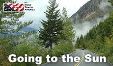
Recent trips include driving the Going to the Sun Road in Montana, Trail Ridge Road in Colorado, and the Loneliest Road in America in Nevada .
In 2019 we made a return visit to Victoria BC , one of our favorite destinations in Canada, along with stays in Banff and Lake Louise .
This website also features travel information and reviews on the most popular national parks such as Great Smoky Mountains National Park and other museums and monuments, such as Mount Rushmore . And be sure to check out our newly published Alaska Travel Guide.
Hopefully our travel experiences will be of interest and benefit to website viewers as they plan their travel itineraries for 2024.
The interactive map below highlights many of the more popular travel destinations in America, including national parks, scenic byways, historic sites, museums and favorite travel cities.
Popular Road Trips on Scenic Byways

"The Mother Road " stretched 2,448 miles from Chicago, heading south through Illinois and Missouri. From there Route 66 turned in a more westward direction through Oklahoma and Texas, with the final stretches in New Mexico and Arizona before ending in Los Angeles.
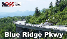
The Blue Ridge Parkway meanders for 469 miles through Virginia and North Carolina, offering endless outdoor recreational opportunities. It provides a slow-paced and relaxing drive revealing stunning long-range vistas and close-up views of the rugged mountains and landscapes of the Appalachian Highlands.
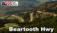
The Beartooth Highway, is one of the most scenic drives in the U.S., with views of the Absaroka and Beartooth Mountains, and open high alpine plateaus. The road features glacial lakes, forests, valleys, waterfalls and a variety of wildlife. It traverses a series of steep switchbacks at the Montana-Wyoming border to the 10,947 ft Beartooth Pass.
US 50 crosses the central portion of Nevada, from the west side of the state near Lake Tahoe to the east side near Great Basin National Park.
The Nevada portion of U.S. 50 was named "The Loneliest Road in America" by Life magazine in July 1986.
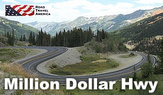
U.S. Highway 550 in Colorado is a two-lane mountainous road. It is one of only two north–south U.S. Highways in Colorado which runs west of the Continental Divide.
The 25-mile section of U.S. 550 from Silverton to Ouray is frequently called the Million Dollar Highway .
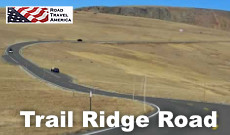
Trail Ridge Road is a paved, 48 mile long scenic highway in Rocky Mountain National Park in Colorado. It connects the park entrances in Grand Lake and Estes Park . The road features switchbacks and hairpin curves, and rises to a height of 12,183 feet above sea level. The road is open seasonally in non-winter months.
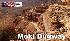
The Moki Dugway is a steep, gravel three mile road located in southeastern Utah, traversing 1,200 feet from the top of Cedar Mesa to the broad valley below. The road is actually part of Utah Highway 261, most of which is paved.
Travel to National Parks
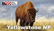
Yellowstone National Park is the world's first national park. It is located mostly in Wyoming, and spans 63 miles north to south, and 54 miles east to west. Geysers, hiking, camping, bison, elk and more!
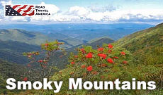
Smoky Mountains Park spans over 800 square miles in Tennessee and North Carolina, and is one of the most pristine natural areas in the Eastern part of the United States. An endless variety of outdoor activities!
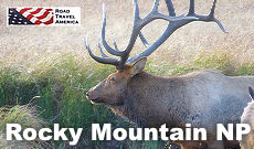
Rocky Mountain National Park is located in Colorado, and consists of 415 square miles of spectacular mountain environments. A highlight of the park is Trail Ridge Road which crests at over 12,000 feet. The park also features over 300 miles of hiking trails, lakes and wildlife.
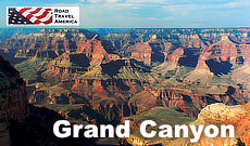
Grand Canyon National Park is located in Arizona, and is centered on a Colorado River canyon that is 277 river miles long, up to 18 miles wide, and a mile deep.
Trending Destinations: February, 2023
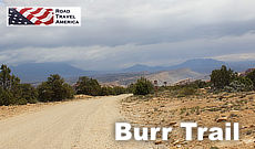
The Burr Trail takes the adventurous traveler into some of Utah's most beautiful and extraordinary country, with views of the Henry Mountains, the colorfully contorted Waterpocket Fold, red Circle Cliffs, and Long Canyon.
The famous Burr Trail switchbacks rise steeply up through the canyon. The trail drops nearly 800 feet in about a mile, while zigging and zagging down the Waterpocket Fold.
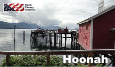
Hoonah is situated on the northwest shore of Chichagof Island across Icy Strait from the entrance to Glacier Bay on Alaska’s scenic Inside Passage.
Known as the Little City with a Big Heart, Hoonah is a family-oriented and closely-knit community of friendly and caring people. Hoonah is about 40 air miles west of the Alaska Capitol in Juneau.

With a perfect growing climate, Victoria is known internationally as the City of Gardens. The Butchart Gardens, just north of Victoria in Brentwood Bay, are internationally known and appreciated, and host over a million visitors annually.
The Butchart Gardens feature a million bedding plants in over 900 varieties.
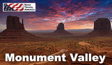
Monument Valley Navajo Tribal Park is located in extreme southeastern Utah, on the northern border of Arizona.
The valley is host to towering sandstone rock formations that have been sculpted over time and soar 400 to 1,000 feet above the valley floor. Combined with the surrounding mesas, buttes, and desert environment, Monument Valley is one of the natural wonders of the world.
SITE MAP | PRIVACY POLICY | TERMS OF USE | CONTACT US
Copyright © 2024 • RoadTravelAmerica.com • All Rights Reserved
- Le Français

Plan your next dream trip to the USA in seconds.

How it works


United States
Navigate forward to interact with the calendar and select a date. Press the question mark key to get the keyboard shortcuts for changing dates.
Navigate backward to interact with the calendar and select a date. Press the question mark key to get the keyboard shortcuts for changing dates.
United States Trip Planner
Top destinations in the united states.

Explore nearby places
- the United States
- Yates Center
All related maps of the United States
- Map of the United States
- Map of Iola
- Map of La Harpe
- Map of Piqua
- Map of Humboldt
- Map of Chanute
- Map of Yates Center
- Map of Garnett
- Map of Mapleton
- Map of Benedict
- Map of Walnut
- Map of New Strawn
- Map of Saint Paul
- Map of Toronto
- Map of Greeley
- Map of Richmond
- Map of Fulton
- Map of Farlington
- Map of Fort Scott
- Map of Neodesha
- Map of Pleasanton
- Map of Girard
- Map of Parsons
- Map of La Cygne
- Map of Fontana
- Map of McCune
- Map of Osawatomie
- Map of Sycamore
- Map of Arma
- Map of Ottawa
- Map of Arcadia
the United States throughout the year
- the United States in January
- the United States in February
- the United States in March
- the United States in April
- the United States in May
- the United States in June
- the United States in July
- the United States in August
- the United States in September
- the United States in October
- the United States in November
- the United States in December
Q&A about the United States
Add places from guides with 1 click, collaborate with friends in real time, import flight and hotel reservations, expense tracking and splitting, checklists for anything, get personalized suggestions.
4.9 on App Store, 4.7 on Google Play
Enter your email address below to view the latest Visit USA newsletter and receive special Travel Offers.
You’ll get plenty of ideas to help you decide where to go and what to do!
By providing your email address and clicking “submit” you consent to be contacted by Visit USA with offers and updates which we feel may be of interest to you. To opt out, use the unsubscribe link or email [email protected] . Find out how Visit USA safeguards user information by reading our Privacy Statement .

Explore the USA
Explore by state, our latest offers.
Our latest travel offers direct to your inbox
Plan your trip
Request our FREE travel planner
Use the interactive map below to click on the US State you are interested in - or use the Explore by State dropdown menu above - and find useful facts, inspirational ideas, offers and videos about each area.
Whether you are a first-time visitor or returning to explore more of the USA, the US State map below provides a great way of exploring different destinations and understanding how they fit together.
Just pick a destination from the dropdown menu or click on our interactive map to start planning your USA trip and you can access a guide to each US State.
From useful facts, to the latest inspirational ideas , offers , brochures and videos the possibilities are endless. Every state is different and has so much to offer. Just pick a destination from the dropdown menu or click on our interactive map to start planning your USA trip! The United States of America is a country that is so vast that one visit is never enough! it truly has some great places to explore. While America’s big cities often grab the limelight the nation’s state capitals are also worth a closer look. Although some capitals are also their state’s main tourism hubs – such as Denver , Boston and Nashville – others are smaller but no less lively or captivating. Weekends away in America’s lesser-known capital cities are the next big thing. Montpelier, Vermont , the smallest of all 50 state capitals, is big on arts, music, world beating breweries and eating out, for example, while others like Carson City, Nevada , are popular bases for outdoor activities. Head on down to Tennessee for a taste of the real America and to experience the best of its musical heritage. Tennessee is all about authentic experiences. Whether in the major cities of Memphis, Nashville, Knoxville or Chattanooga, or in some of America’s most inspiring small towns, like Franklin, Collierville or Cleveland, Tennessee delivers hospitality and a true American experience. Alternatively, holiday in the state of Kentucky where southern hospitality is what it’s all about in the Bluegrass State. Here visitors can taste bourbon, enjoy the races and explore the great outdoors. Kentucky is home to Mammoth Cave, the longest cave system in the world, as well as thousands of miles of waterways. Explore Washington D.C. , the nation’s capital and home to the US President and Congress with many important government buildings and monuments to explore. Or visit the East Coast perfect for a short break, and explore America’s largest city New York , home to many skyscrapers, museums and theatres. Find out all about the U.S. states and territories using the interactive map, or read the “State Round-up” in our travel planner .
Visit USA | E-Newsletter Sign-up
By providing your email address and clicking “sign-up” you consent to be contacted by Visit USA with offers and updates which we feel may be of interest to you. To opt out, use the unsubscribe link or email [email protected] . Find out how Visit USA safeguards user information by reading our Privacy Statement .

- Wall maps, travel maps, guide books, globes and more!
- Finishing Options

- Search for:
No products in the cart.
Return to shop
- Personalized Maps
- Best Selling Maps
- Political Maps
- Physical Maps
- Historical Maps
- Africa Maps
- Antarctica Maps
- Australia Maps
- Europe Maps
- North America Maps
- South America Maps
- Country Maps
- International Region & City Maps
- U.S. Region, City, County Maps
- Congressional Maps 2022
- City & County Maps
- Classroom Pull Down Maps
- Topographic Maps
- Foreign Language Maps
- Space, Science, Culture & More
- Map Accessories
- World Raised Relief Maps
- United States Raised Relief Maps
- State Raised Relief Maps
- USGS Region Raised Relief Maps
- National Park Raised Relief Maps
- Other Raised Relief Maps
- Best Selling Combo Maps
- Elementary Classroom Maps
- Middle School Classroom Maps
- High School & College Classroom Maps
- History Maps
- Custom Spring Rollers
- Spring Roller Installation
- NOAA Charts
- U.S. Folding Maps
- Regional Folding Maps
- State Folding Maps
- City Folding Maps
- Continent Folding Maps
- Country Folding Maps
- National Park Maps
- National Forest Maps
- Appalachian Trail Maps
- World Atlases
- U.S. Atlases
- U.S. State Atlases
- Folding Maps
- Professional Driver Atlases
- For Business
- For Decoration
Folding Travel Maps - United States
Browse our large selection of hundreds of United States folding travel maps. This section is divided into U.S. Travel Maps, Regional U.S. Travel Maps, U.S. State Travel Maps, and U.S. City Maps. Get your hands on the right map with the right detail for your next trip abroad. Use the search at the top-right of the website to find a map for a specific region or simply browse the products below. We love technology and enjoy the convenience of GPS, but you can’t plan a trip on a phone screen and navigation doesn’t work where there’s no cell signal. Start your next trip on the right foot with a high-quality folding travel map. Make the most of your next adventure, even if you lose GPS or cell signals. You’ll always be on the correct route with our folding travel maps. Your adventure starts here! Please contact us if you need help choosing the perfect map for your travels.
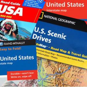
U.S. Folding Travel Maps
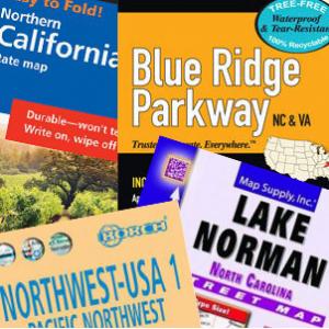
Regional United States Maps
30 Products
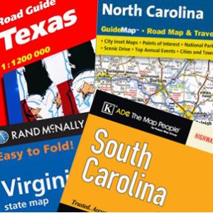
US Folding State Maps
103 Products
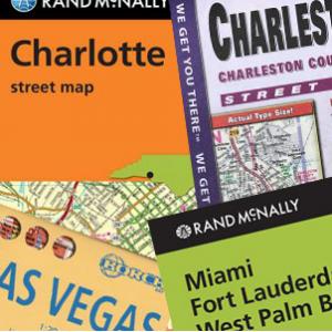
US Folding City Maps
80 Products
- Continent Maps
- United States Maps
- Kids Section
- International Maps
- States Maps
- USGS Regional Maps
- Map Pins, Markers & Stickers
- Mounting Hardware
- Need Help? 704-332-5557
Username or email address *
Password *
Remember me Log in
Lost your password?

Please note that creating presentations is not supported in Internet Explorer versions 6, 7. We recommend upgrading to the latest Internet Explorer, Google Chrome, or Firefox. If you are using IE 8 or later, make sure you turn off "Compatibility View".
Account Options
- North America /
- United States /
- Detailed maps /
Detailed Road Map of United States
This is not just a map. It's a piece of the world captured in the image.
The detailed road map represents one of many map types and styles available. Look at United States from different perspectives.
Get free map for your website. Discover the beauty hidden in the maps. Maphill is more than just a map gallery.
- Free map
- Panoramic 203
- Location 165
The default map view shows local businesses and driving directions.
Terrain Map
Terrain map shows physical features of the landscape. Contours let you determine the height of mountains and depth of the ocean bottom.
Hybrid map combines high-resolution satellite images with detailed street map overlay.
Satellite Map
High-resolution aerial and satellite imagery. No text labels.
Maps of United States
This detailed map of United States is provided by Google. Use the buttons under the map to switch to different map types provided by Maphill itself.
See United States from a different perspective.
Each map style has its advantages. No map type is the best. The best is that Maphill enables you to look at the same country from many different angles.
Sure, this road detailed map is nice. But there is good chance you will like some other styles of United States map even more. Select another style in the above table and look at the United States from a different view.
What to do when you like this map?
If you like this United States map, please don't keep it to yourself. Give your friends a chance to see how the world converted to images looks like.
Share this map.
Use the buttons for Facebook, Twitter or Google+ to share a link to this United States map. Maphill is the largest map gallery on the web. But the number of maps is certainly not the only reason to visit Maphill.
Get free map of United States.
You can embed, print or download the map just like any other image. All United States detailed maps are available in a common image format. Enrich your website or blog with hiqh quality map graphics.
Free images are available under Free map link located above the map.
Is there anything more than this map?
Sure, there is. It has been said that Maphill maps are worth a thousand words. That's certainly true. But you can experience much more when you visit United States.
Be inspired. Visit United States.
United States has a lot to offer and a lot to see. It is not possible to capture all the beauty in the map.
United States hotel deals.
If any of Maphill's maps inspire you to come to United States, we would like to offer you access to wide selection of hotels at low prices and with great customer service. Best price is guaranteed.
Thanks to our partnership with Booking.com you can take advantage of up to 50% discounts for hotels in many cities and regions of United States. Compare hotel prices, book online and save money.
United States hotels
See the full list of destinations in United States or choose from the below listed cities.
Hotels in popular destinations in United States
- Philadelphia hotels »
- New York hotels »
- Chicago hotels »
- Los Angeles hotels »
- San Diego hotels »
- Detroit hotels »
- Baltimore hotels »
- Seattle hotels »
- New Orleans hotels »
- Cleveland hotels »
- Miami hotels »
- Minneapolis hotels »
- Pittsburgh hotels »
- Cincinnati hotels »
- Buffalo hotels »
- more »
Learn more about the map styles
Each map type offers different information and each map style is designed for a different purpose. Read about the styles and map projection used in the above map (Detailed Road Map of United States).
Detailed street map and route planner provided by Google. Find local businesses and nearby restaurants, see local traffic and road conditions. Use this map type to plan a road trip and to get driving directions in United States.
Switch to a Google Earth view for the detailed virtual globe and 3D buildings in many major cities worldwide.
Mercator map projection
This map of United States is provided by Google Maps, whose primary purpose is to provide local street maps rather than a planetary view of the Earth. Within the context of local street searches, angles and compass directions are very important, as well as ensuring that distances in all directions are shown at the same scale.
The Mercator projection was developed as a sea travel navigation tool. It preserves angles. If you wish to go from United States to anywhere on the map, all you have to do is draw a line between the two points and measure the angle. If you head this compass direction, and keep going, you will reach your destination.
Popular searches
A list of the most popular locations in United States as searched by our visitors.
- Franklin County
- New Orleans
- United States
Recent searches
List of the locations in United States that our users recently searched for.
- Sneads Ferry
- EW 117 Road
- 4922 SW Dawson St
- 1068 Cresthaven Rd
- 1901 Wild Holly Ln
- Red Rock Canyon
- Larch Camp Road
- 1050 Pacific Dr
The Maphill difference
It's neither this road detailed map nor any other of the many millions of maps. The value of a map gallery is not determined by the number of pictures, but by the possibility to see the world from many different perspectives.
We unlock the value hidden in the geographic data. Thanks to automating the complex process of turning data into map graphics, we are able to create maps in higher quality, faster and cheaper than was possible before.
Forever free
We created Maphill to make the web a more beautiful place. Without you having to pay for it. Maphill maps are and will always be available for free.
Real Earth data
Do you think the maps are too beautiful not to be painted? No, this is not art. All detailed maps of United States are created based on real Earth data. This is how the world looks like.
Easy to use
This map is available in a common image format. You can copy, print or embed the map very easily. Just like any other image.
Different perspectives
The value of Maphill lies in the possibility to look at the same area from several perspectives. Maphill presents the map of United States in a wide variety of map types and styles.
Vector quality
We build each detailed map individually with regard to the characteristics of the map area and the chosen graphic style. Maps are assembled and kept in a high resolution vector format throughout the entire process of their creation.
Experience of discovering
Maphill maps will never be as detailed as Google maps or as precise as designed by professional cartographers. Our goal is different. We want to redefine the experience of discovering the world through the maps.
Fast anywhere
Maps are served from a large number of servers spread all over the world. Globally distributed map delivery network ensures low latency and fast loading times, no matter where on Earth you happen to be.
Spread the beauty
Embed the above road detailed map of United States into your website. Enrich your blog with quality map graphics. Make the web a more beautiful place.
Maphill is the web's largest map gallery.
Get a free map for your website. Explore the world. Discover the beauty hidden in the maps.
Map graphics revolution.™
❌ An error occured!
Something, somewhere went wrong 😞., if you have the time, please send me an email to [email protected] with the following error report:, thanks for helping with the development of mapchart 🙌, 🐞 bug report.
- This may happen when using the browser's page zoom to enlarge the map.
- Although Page Zoom wasn't officially supported, I understand it was a go-to choice for many.
- Please try using the website's own Zoom Mode (at the left side of every map).
- It's designed to keep your map sharp and detailed as you zoom in.
- You can edit maps with the zoom mode on; it also includes a d-pad for navigation.
Something went wrong? Please send a bug report!
This includes details on your browser/OS, and a list of the last edits you made on the map, so that I can reproduce the issue:
To send it, you can:
- Email the report to [email protected] or use the Feedback page.
- Send it anonymously... . Note that, this way, I won't be able to get back to you.
If you send via email, please consider adding a screenshot to your report.
Need more customization options?
Get mapchart plus for a dark website theme and 5 extra map themes..
- Quickly customize your map with extra map themes.
- A dark theme for the whole website.
- My Maps: save all maps you make to your account.
- My Palette: save your favourite colors and patterns to your account and find them quickly.
- and more...
Save / Load Configuration
- Save/Load text file
- Using My Maps My Maps (Plus only)
Click the button below to save your current map settings (colors, borders, legend data) as a mapchartSave.txt file:
To load a previously saved map configuration, upload the mapchartSave.txt file below:
or drag and drop your config file here, or,
Note: Loading a new configuration will replace all current map data.
This configuration was created with an older version of MapChart. The legend position and size may be a bit off. Adjust them as needed and save the map again.
Want more features, like saving maps to your account and an ad-free experience? Get MapChart Plus .
Your work is automatically saved as you make changes to your map. Each page on the website has its own autosave, stored in your browser's cache.
Note: Restoring an autosave will replace all current map data. Use undo to go back to the previous state.
Using My Maps
As a Plus user, you can save your map settings to My Maps and access it any time you want. A quick guide:
- Color and edit your map as you want. To save your progress, hit Save at the left edge of the map.
- Select a name for your save file and hit Save .
- Keep editing your map. Use Save to save your progress again. Use Save as... to save your current map with a different name.
- Use the Load... button to see a list of all maps you have saved for this page. Select Load to resume editing your saved map.
- You can check all your saved maps for all map pages on the My Maps page.
- You can still use the save/upload text files process.
- If you load the wrong map by mistake, use the Undo button to go back.
Get MapChart Plus to create your own account and save your map configurations online.
- Save all the maps you make to your account.
- Load map settings from My Maps whenever you want.
- Log in to your account from any device and continue working on your maps.
- No need to use config text files any more!
Difference between scaling and nonscaling patterns
What is this.
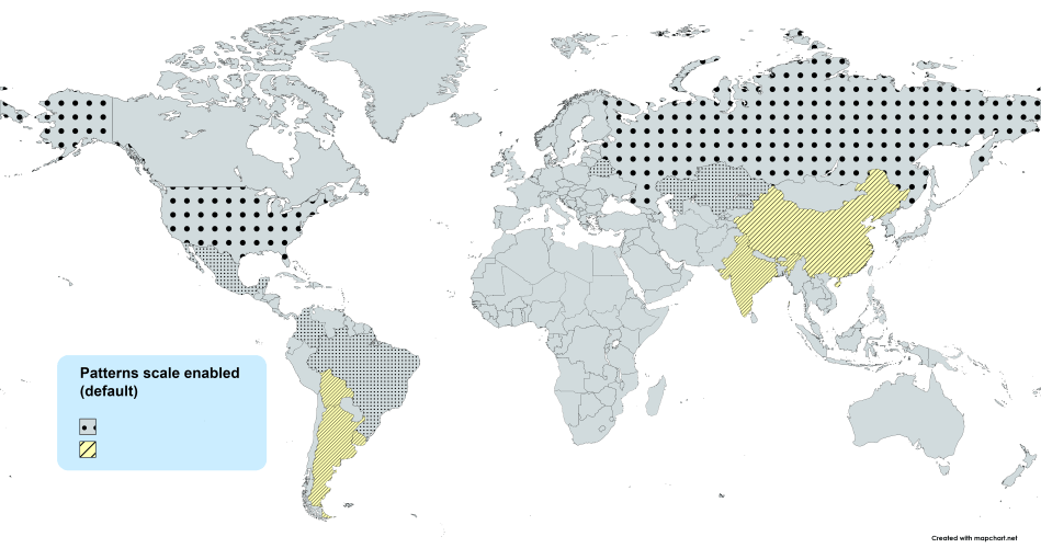
When you color a state with a pattern (dots, stripes, etc.), the pattern by default gets scaled (resized) to fit its size . You can change this to use nonscaling patterns that look the same on all states. Examples:
Scaling (default)
What to choose?
It can depend on the map or the patterns/colors you select, but generally:
- Scaling patterns (default) are better for maps with small subdivisions, like the detailed maps or the US counties map.
- Scaling patterns (default) are better for zoomed in areas.
- Nonscaling patterns can look better for maps with larger subdivisions, like the simple World map or the US states map.
- Nonscaling patterns can look better when you have a small number of patterns in your map, as they stand out more.
In any case, you can switch this setting on/off as many times as you need to see the difference live on your map. More details on the blog .
Advanced settings
keyboard shortcuts.
∗ Change this behavior in Advanced settings.
Right-click on a state to remove its color or pattern, copy a color/pattern from another state, show, or hide it.
In the legend table, click on a color box to change the color for all states in the group . Right-click on it to select the color again or use the numpad keys 1 to 9 .
Map scripts
Run a script from the table below to quickly modify or get data from the map.
Save to My Maps
Save the current map's settings to my maps..
A new config file will be created. While editing your map, hit the Save button again, to save your progress.
Load from My Maps
Find all your saved map configurations below..
Loading a configuration replaces your current map . Use Undo to go back if needed.
* Showing configurations from compatible maps (e.g. from the Europe map, if you are on a world map page).

Share your map settings
Send this link to anyone on the web and they will be able to directly load your map's settings..
* This link will always point to the latest version of this map.
Map settings loaded!
This map configuration was shared with you by a mapchart plus user., get mapchart plus to save your map configurations online and share them with others..
- Share your maps with others, even if they don't have a Plus account.
Create a pattern
Zoom mode settings, for the keyboard shortcuts w a s d and the arrow controls:.
Your preferences will be saved to your browser's cache.
Selection settings
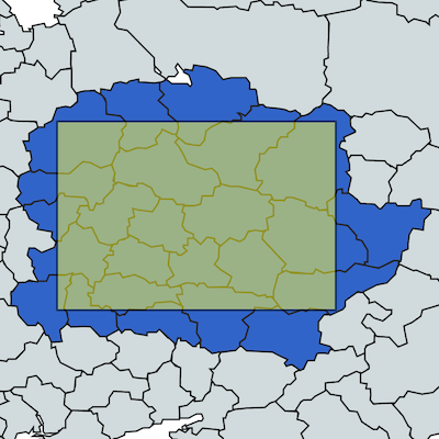
Select all states that the selection:.
Your preference will be saved to your browser's cache.
Zoom tutorial
Double-click to zoom in.
Use the keyboard shortcuts I O or + - to zoom in/out and W A S D or the keyboard arrows to move the map.
Use the controls at the bottom right of the map for the same functions.
Click on Reset or use R to set the map to its initial zoom.
Click on EXIT ZOOM or use Esc to stop the zoom tool.
While in zoom mode, you can still edit the map, change colors, etc.
Splitting states
Right-click on a state and select Split state into parts :
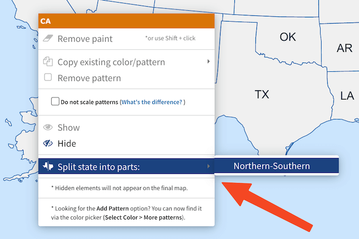
To go back, right-click on a state part and select Show state as a whole or use the Undo button.
⚠️ Not all states can be split. For suggestions, let me know through the Feedback page .
- The way each state is split is mostly arbitrary and meant to be used as a way to further customize your map.
- This is only available for this map page.
- If you want a more granular division, please use the US Counties map page . Remove the county borders to achieve a better result.
- States that can be split: AL, AR, AZ, CA, CO, DE, FL, GA, IA, IL, IN, KS, KY, LA, MD, MI, ME, MO, MS, MT, NC, ND, NM, SD, NE, NJ, NV, NY, OH, OK, OR, PA, SC, TN, TX, UT, VA, WA, WI, WV, WY.
Let's play a game!
Can you guess the from the hints.
Click on a state to make a guess. For instance, if you select California, you're guessing that the hidden country is the United States.
Your map progress has been saved. You can continue later.
If you had fun with this, you'll love MapGame!
Just launched, it's a daily game where you try to guess the hidden country from hints, just like the ones you saw.
Play it now at mapgame.net .
If you do try it out, please share your results with your friends. Here is how I did in today's quiz:
Found the country in 39 seconds! ✅ ✅❌ ✅❌✅ ❌❌✅❌ ✅✅✅✅✅
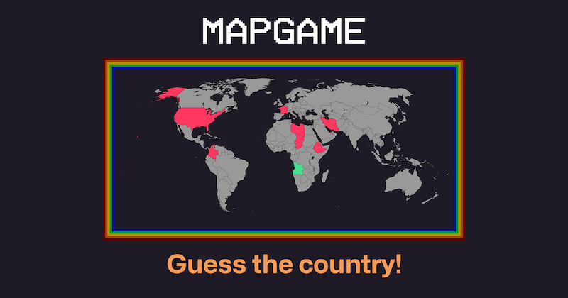
Quit MapGame?
This was a preview of mapgame..
It's a daily game where you try to guess the hidden country from hints, like the ones you just saw.
You can play it on mapgame.net .
Save the keyboard shortcuts you want to remember
Try Shortcut Keeper — a simple app to get more productive with your Mac.
United States
- Default Label Legend
- Dark Label Legend
- Aqua Label Legend
- Muted Label Legend
- Marine Label Legend
- Royal Label Legend
- Modern Label Legend
- Ancient Label Legend
- Cork Label Legend
- Ocean Label Legend
- Ash Label Legend
- Matrix Label Legend
- The 90s Label Legend
- Default (light)
Your choices will be saved for your next visits to this map page.
Zoom active
Select the color you want and click on a state on the map. Right-click to remove its color, hide, and more.
Add a title for the map's legend and choose a label for each color group . Change the color for all states in a group by clicking on it.
Drag the legend on the map to set its position or resize it. Use legend options to change its color, font, and more.
Update April 12, 2024
Information for u.s. citizens in the middle east.
- Travel Advisories |
- Contact Us |
- MyTravelGov |
Find U.S. Embassies & Consulates
Travel.state.gov, congressional liaison, special issuance agency, u.s. passports, international travel, intercountry adoption, international parental child abduction, records and authentications, popular links, travel advisories, mytravelgov, stay connected, legal resources, legal information, info for u.s. law enforcement, replace or certify documents.
Share this page:
Learn about your destination
Take 90 seconds for safer travel.
Travel Advisory Levels
Enroll in step.

Subscribe to get up-to-date safety and security information and help us reach you in an emergency abroad.
Recommended Web Browsers: Microsoft Edge or Google Chrome.
External Link
You are about to leave travel.state.gov for an external website that is not maintained by the U.S. Department of State.
Links to external websites are provided as a convenience and should not be construed as an endorsement by the U.S. Department of State of the views or products contained therein. If you wish to remain on travel.state.gov, click the "cancel" message.
You are about to visit:

The Amazing Times
35 Maps That Show Us Lesser Known Facts About America
Posted: April 19, 2024 | Last updated: April 27, 2024
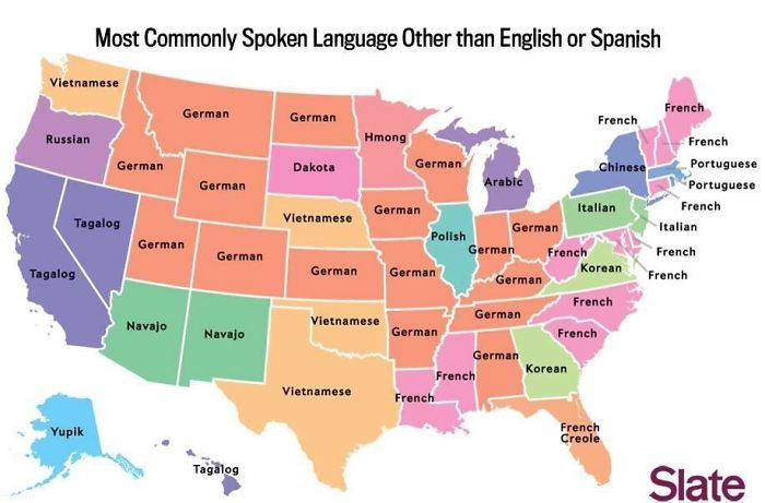
Most Commonly Spoken Language
These are the languages that the states speak the most, after English and Spanish. However, take the map with a grain of salt since commenters on the Reddit post have pointed out quite a few inconsistencies and mistakes.
Read More: 40 Pics of Things You Don't Often See
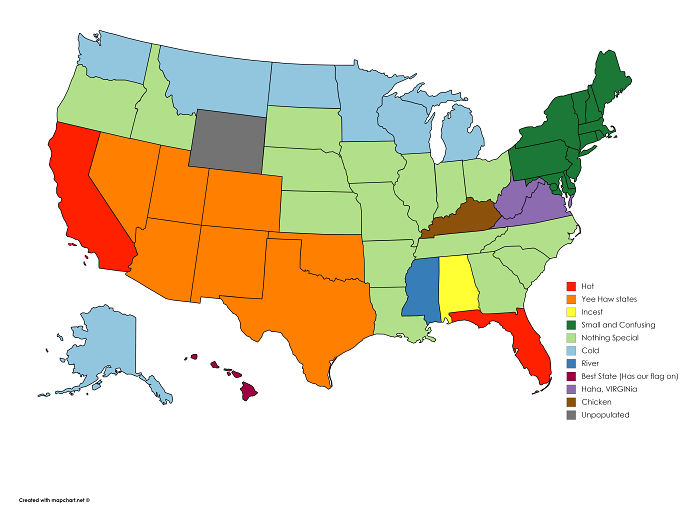
The Perspective Of A Brit
This is absolutely not an official map if the title is not clear enough. It’s actually a British Reddit user’s attempt at sharing how he looks at America, at a glance.
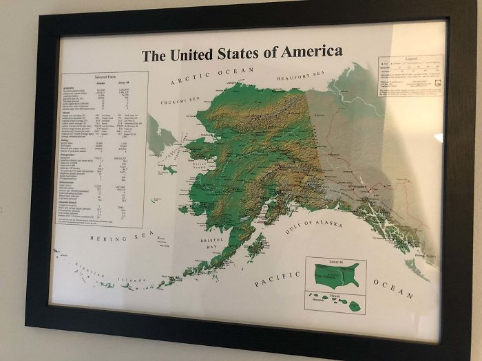
America From Alaska
If this map of the USA looks extremely different from what you are used to, then you are correct. It is. Those with keen eyes may have already noticed that the usual map is in the bottom right corner. The bigger map is only a map of the state of Alaska.
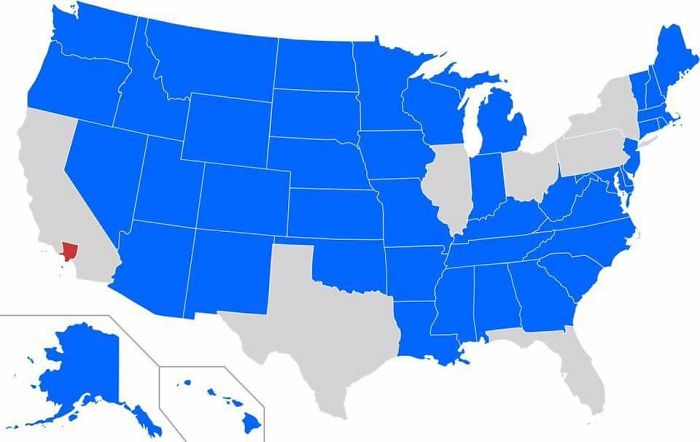
States With Less People Than LA
Los Angeles is marked in red. Every state that has a population smaller than LA is marked in blue. It might look surprising, but as a commenter points out: “ Yeah, but to be fair, half of the US is basically uninhabited nothingness. “
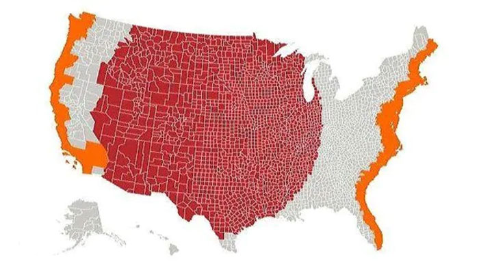
Red And Orange Have Equal Population
The total population in the area marked in red is equivalent to the total population in the area marked in orange. The coastal areas of the country are a lot better places to live in, apparently.
Read More: 30+ Most Dangerous Beaches In The World
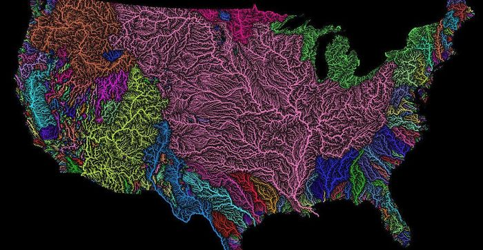
US Watersheds
An explanation for watersheds from a commenter: “ For those that don’t know, a watershed is a geologic area from which all water drains to the ocean. The pink area is the Mississippi River basin which includes the Missouri, Ohio, Platte, Allegheny, Red, and Arkansas rivers (among many, many others) .”
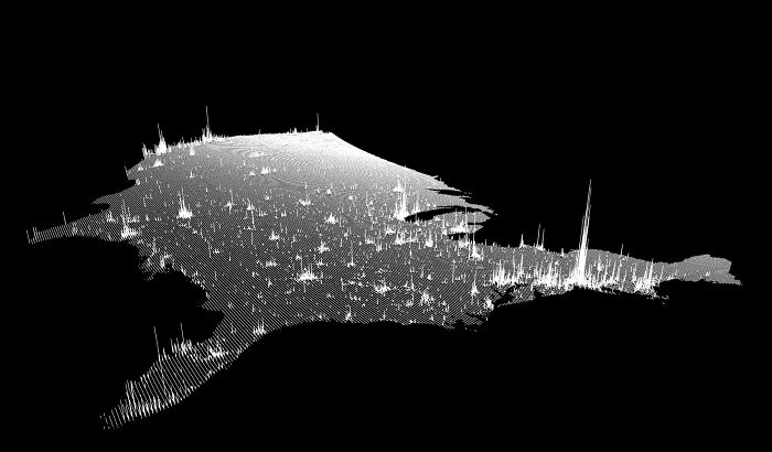
Population Lines
This map is a vertical representation of the population density in the United States of America. The taller the line, the higher the number of people living in that area.
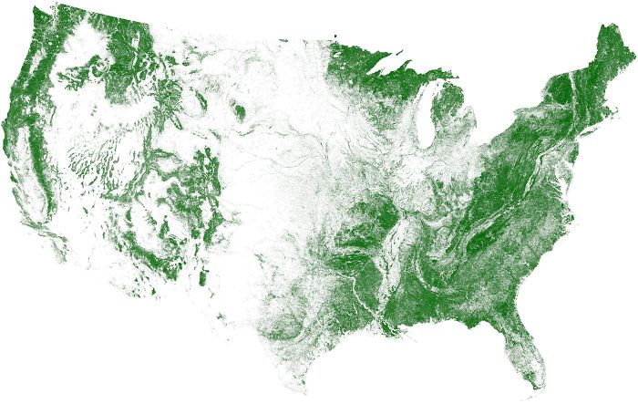
Tree Cover in The US
This map shows the density of trees in the United States. The middle of the country is quite barren compared to the coastal areas.
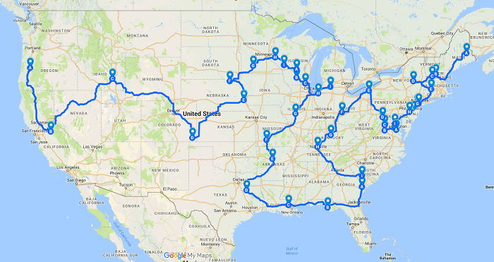
The Shortest Route Between Every Springfield
As is clear, there’s a lot more than one place called “Springfield” in the United States. This map shows the route that you can take to reach every one of them, fastest. For the record, the one in The Simpsons is believed to be in Oregon.
Read More: Widow Donates $1 Billion to Cover Tuition for NYC's Poorest Area Forever
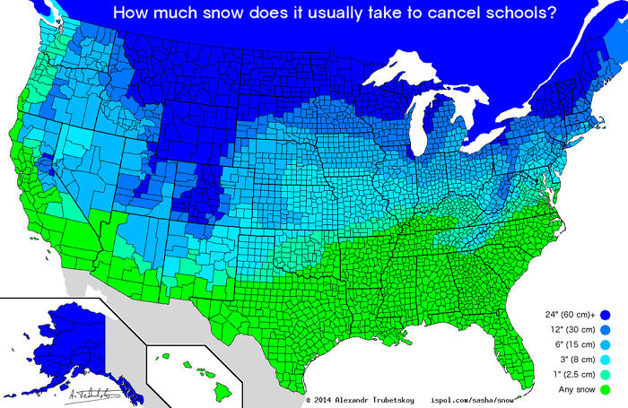
Snow Taken To Cancel School
You would think that the entire country would have the same marker when it comes to how much snow is too much for school. However, that is not the case. Humans are quite adaptable to their living conditions, after all.
Read More: 37 Men Dressed In Their National Costumes for a Male Beauty Pageant
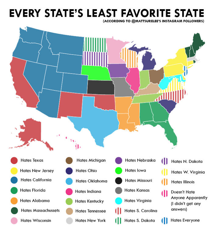
The Least Favorite State Of Every State
Quick disclaimer: this measure of hatred is only according to the OP’s followers on Instagram. Even then, it seems like California should perhaps work on being a bit more likable. Also, New Jersey is too sour.
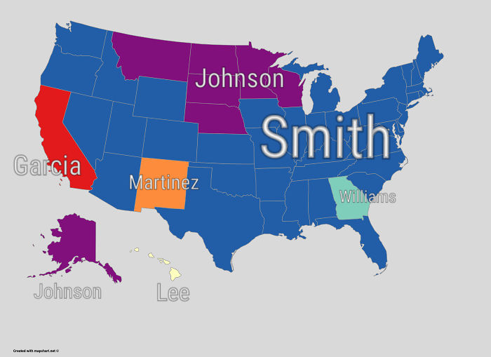
Most Common Surname By State
Statistically, Smith is also the most commonly used made-up name in the English language. Also, “Li” is the world’s second most common surname, followed by “Wang”.
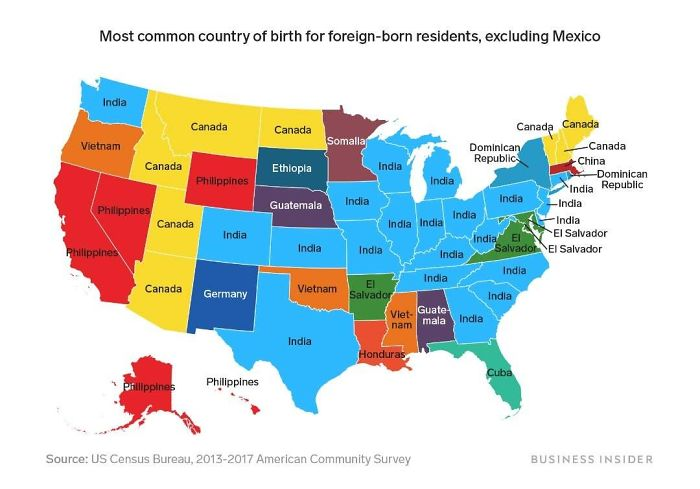
Most Common Country Of Birth For Foreign-Born Residents
Another quick disclaimer: this map only shows the countries that are not Mexico because as many as 32 out of the 50 states would then be showing Mexico. As you can see, Indians make up a large portion of the population.
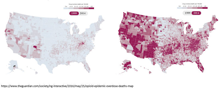
Deaths Due To Drug Overdoes (1999 vs 2014)
This map is a much more depressing statistic. The map shows how many people lost their lives per 100,000 due to drug overdose in 1999 (Left) and 2014 (Right). Unfortunately, the problem has skyrocketed.
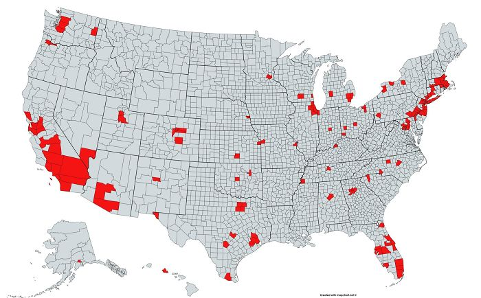
Population Is More In Red Than Grey
Here is another map that shows the grossly uneven population distribution in the United States. The total population in the areas marked in red is higher than that in the areas marked in grey.
Read More: 10 Cars You've Probably Never Heard Of
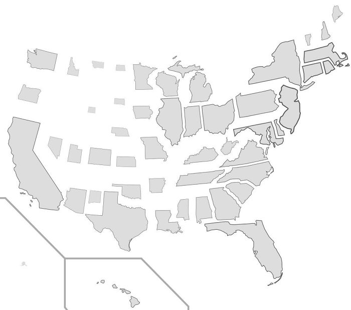
States Scaled According To Population Density
Here, the size of the states has been scaled according to their relative population density in the United States. As you can see, Alaska (one of the largest states) is now one of the tiniest states.
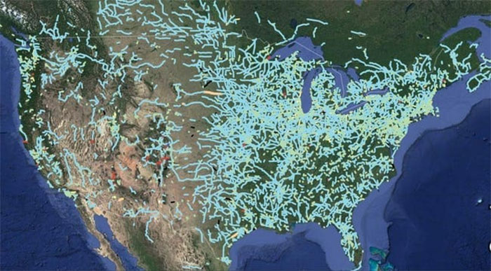
Out-of-service Railway Lines
This is a look into the history of the country. These are all the railway lines that were once bustling with use but have now become obsolete and abandoned.
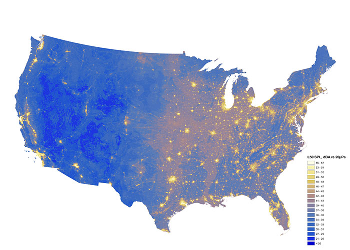
Quietest And Loudest Spots
Ever wondered if your area is loud or silent compared to the rest of the country? Well, now you can see it represented on the map. The yellower it is, the louder it is.
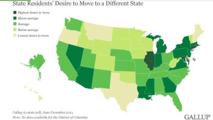
Map of Desire to Move
If you are living in any of the states that are dark green, and want to move, then you are not alone. On the other hand, for people in the light yellow states, you are not the norm if you have that desire.
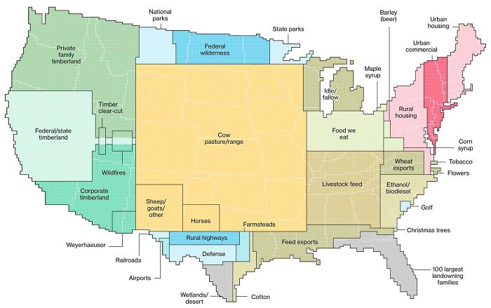
Usage of Land
The central uninhabited expanses of the United States do not go to waste. They are primarily used for agriculture and forestry. This surprised many users on its original Reddit post.
Read More: 10 Historical Facts You Probably Haven't Heard Of
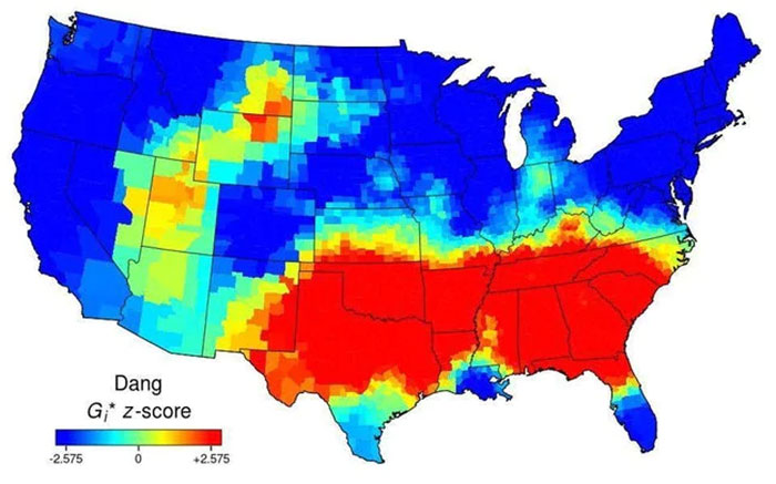
Use of the word “Dang”
“Dang”. You may not be one of the people who use it, but here are the places where you will hear it the most. It’s usually in the Southern part of the country.
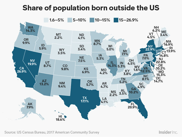
Percentage of People Who Are Not US-Born
To those who are confused as to the real number of “outsiders” in the country – here they are. Not as much as you might be led to believe by some.
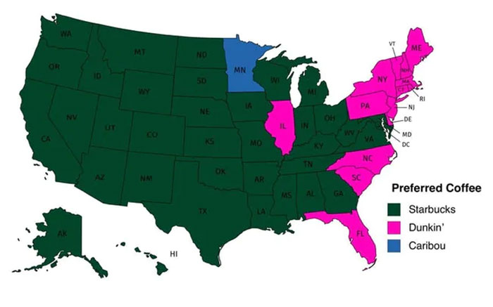
Most Popular Coffee Chain
Do you like Starbucks or Dunkin’? Well, for the majority of the country, Starbucks is the go-to choice. However, for Minneapolis, it seems like Caribou has a special place.
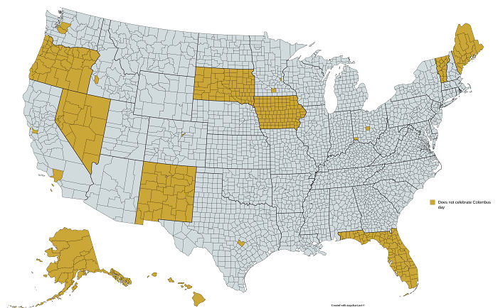
Regions That Don’t Celebrate Christopher Columbus Day
Christopher Columbus is accredited with “discovering” the American continent. However, his atrocities against the native inhabitants at the time are very controversial. These are the regions that do not officially celebrate Christopher Columbus Day.
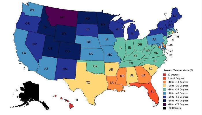
Lowest Recorded Temperature
This map is a testament to the geographical vastness of the United States. These are the lowest recorded temperatures (in Fahrenheit) for every state. It goes from 12 degrees to as low as -80 degrees.
Read More: Oldest Mall In America Turned Into Tiny Homes
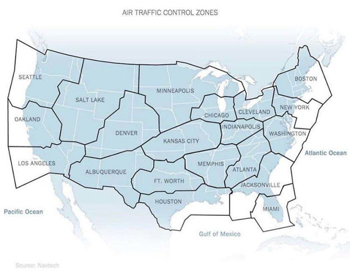
Air Traffic Control Zones
Air Traffic Control Zones do not overlap with state borders. These indicate which air traffic center an airplane should be in contact with, depending on the area they are flying in.
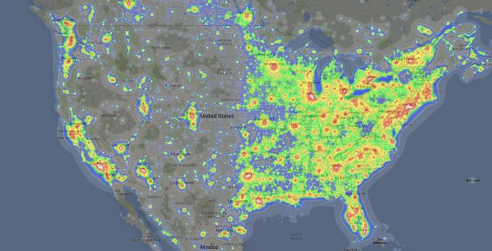
Light Pollution
Interestingly enough, this map indicates that light pollution in one of the most developed countries in the world is kind of split down the middle. For any starwatchers, living on the left side would be much better.
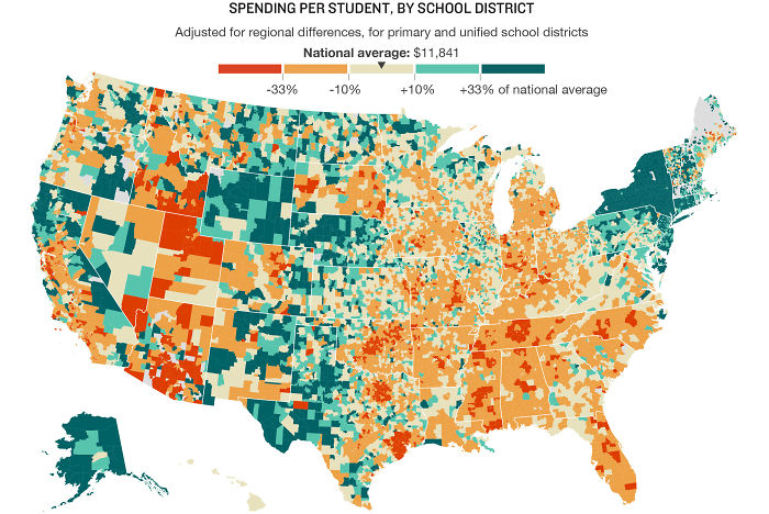
Spending on Education
This map shows a rather interesting social aspect of one of the most powerful countries in the world. The redder the area, the less the State decided to allocate to education.
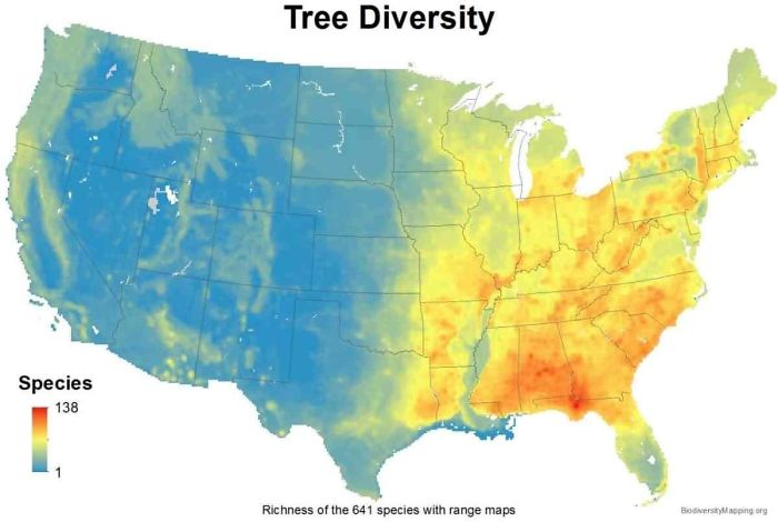
Tree Diversity
This map shows how many kinds of tree species are available in a region. As you can see, on the left side, there’s not a lot of variety. On the other hand, the number can go up to 138.
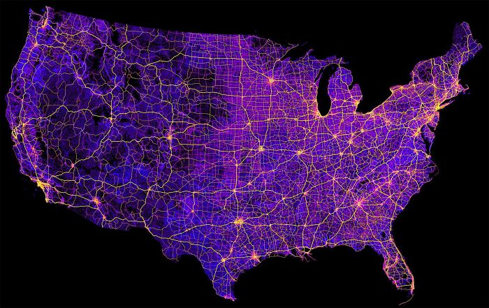
Roads, Streets, and Highways
The United States approximately has 8 million miles of combined streets, roads, and highways. It is a very large country that is quite well-connected.
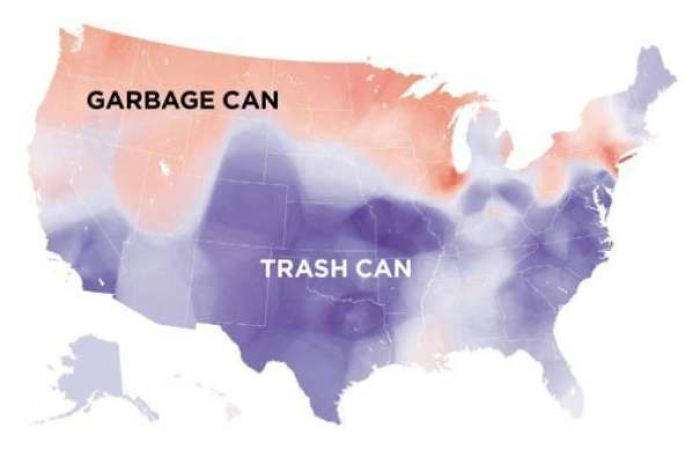
Garbage Can vs. Trash Can
Do you call it a garbage can or a trash can? This map indicates that the term used can change depending on what part of the country you are from.
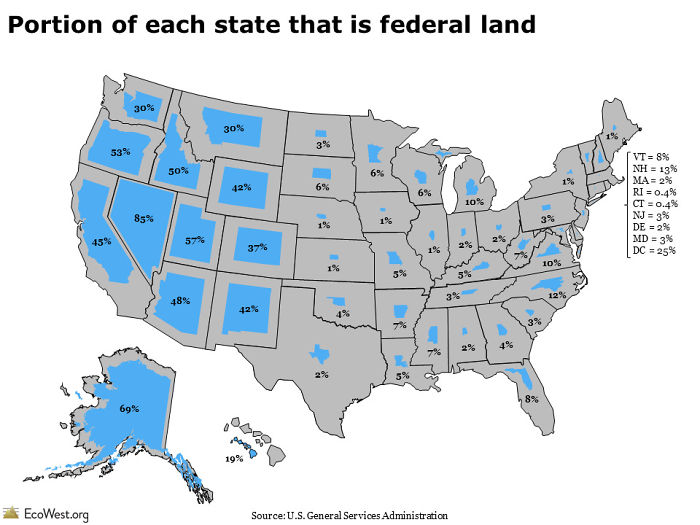
Federal Land
The federal system of government in the United States means that ownership of public property is shared between the federal government and the state government. For some states, the majority of the land is owned by the federal government.
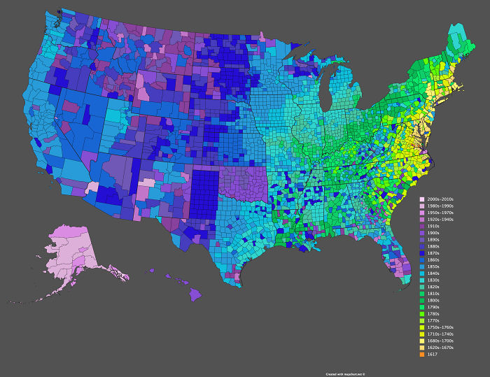
Date of Creation Of Counties
There are a total of 3142 counties in the United States. They were not created at the same time, obviously. The oldest one dates back to 1617, which was before the country’s independence. On the other hand, the latest in the map was created in the previous decade.
Read More: 7 Places to Visit Before You Leave This World
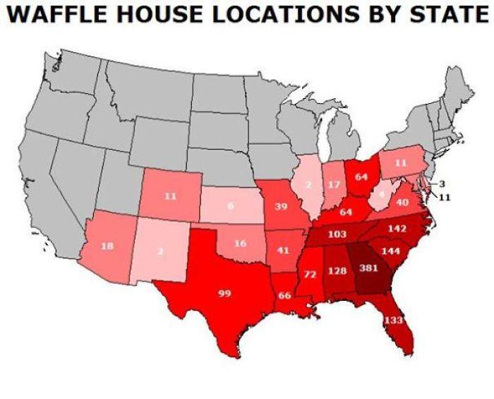
Waffle House
Waffle House is quite a tasty franchise for those on the East Coast. However, it is no more than non-existent on the west coast of the United States.
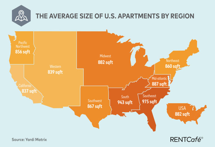
Average Apartment Size
You can now think about whether you are lucky or unlucky with your living situation, depending on where you live. Honestly, anything close to 882 sq. ft. should be fine.
Read More: Bus Driver Buys First Grader New Pajamas So He's Not Left Out on Pajama Day
This content has, in part, been generated with the aid of an artificial intelligence language model. While we strive for accuracy and quality, please note that the information provided may not be entirely error-free or up-to-date. We recommend independently verifying the content and consulting with professionals for specific advice or information. We do not assume any responsibility or liability for the use or interpretation of this content.
The post 35 Maps That Show Us Lesser Known Facts About America appeared first on The Amazing Times .
More for You
Five teams that botched the 2024 NFL Draft
Your senses will shut down in a specific order when you’re about to die
One of these pictures of me is real and the other is AI – but which is which?
Pelosi accuses MSNBC host of being ‘apologist for Donald Trump’
The biggest song in country music history, according to data. Plus, see if your favorite is in the top 100.
Taco Bell Receives Massive Pushback on New Unpopular Menu Change
4 Supplements You Shouldn't Be Taking if You Have High Blood Pressure, According to a Dietitian
They Wrote it Off as School Stress. I Hid the Truth Out of Terror
Archaeologists discover lost home of Rome's first emperor
D.C. police just schooled a university on freedom of speech rights
This is one of the most advanced humanoid robots in the world
Frosted Flakes are banned across Europe and Japan. Here's why, plus more American favorites barred elsewhere.
The Best Potluck Desserts No One Thinks to Bring
6 Things A Doctor Wants You To Do Before Getting A Blood Test
Anthony Davis Exits Lakers-Nuggets Game 5 After Trying to Fight Through Injury
Remembering Fran
Ted Cruz Wants Airlines to Keep Your Cash When They Cancel Your Flight
The Best Haircut for Your Face Shape
Meet one of the world's most advanced humanoids
57 Weeknight Dinners You Haven’t Tried Yet
Region by region: How these states could broaden abortion access

The year began with nationwide conservative efforts to shrink abortion access . Advocates for the procedure hope to end 2024 by reversing some of these restrictions, via the ballot box.
And the outcome of their efforts could have major implications for something opponents have long waged war on − interstate abortion travel.
With ballot initiatives underway in nearly a dozen states to let voters weigh in on where to set the limits, the success or failure of these measures will have impacts beyond state lines and on regions broadly, advocates told USA TODAY.
Acting as a sort of sanctuaries for neighboring abortion access deserts, states with more liberal abortion laws have seen an influx of out-of-state patients since the overturning of Roe v. Wade, the landmark 1973 case guaranteeing a constitutional right to the procedure.
And a slew of proposed abortion-related constitutional amendments in 2024 could add to the map.
Prep for the polls: See who is running for president and compare where they stand on key issues in our Voter Guide
How many people got abortions in 2023? New report finds increase despite bans
“Unless there's a national right to abortion care, we're absolutely doing it state by state, community by community as best as possible,” said Adrienne Mansanares, president and CEO of Planned Parenthood of the Rocky Mountains.
Abortion travel escalated post-Roe
After the U.S. Supreme Court overturned Roe v. Wade and decades of federal abortion precedent in June 2022, decisions around the procedure and any limits or exceptions returned to states, creating a nationwide legislative patchwork.
Over a dozen predominantly red states have implemented near total bans on abortions, while a handful of blue states including Oregon and Vermont allow abortions regardless of the gestational period, according to the Guttmacher Institute, a research group that supports abortion rights. Some states restored an abortion limit similar to that of Roe.
The varying laws have led to a rise in patients traveling between states seeking an abortion, Mansanares said.
Planned Parenthood’s health centers in Colorado, a state with wider abortion access, saw a tenfold increase in patients seeking care from nearby Texas, Oklahoma and Arizona between 2020 and last year, according to the organization's records. In October 2020 through September 2021, their Colorado health centers saw 374 of these out-of-state patients; from October 2022 through September 2023, the clinics served approximately 3,800 patients from the same three states. Over 75% of these women scheduled appointments for abortions.
The bulk of women came from the Lone Star State, where the procedure is almost completely banned.
"When state bans go into effect, they impact the entire country,” Mansanares said.
This year, voters in at least three states will decide whether to enshrine abortion access in their constitution. And there are still ongoing initiatives to add such a decision to the ballot in about a dozen more states, including Colorado.
If passed, these referendums could cement some states’ statuses as abortion access points, while opening new points of access in others.
Women travel both to and from Florida for abortions
Sitting in the southeast where some of the country’s tightest abortion laws are concentrated, Florida has been a relative haven for patients in the South in the wake of Roe’s overturning.
But with the state’s current 15-week limit about to drop to six weeks, after a recent state Supreme Court ruling, women in Florida and the surrounding region could face a shortage of care, said Serra Sippel, interim executive director of The Brigid Alliance, a group that provides resources for abortion travel.
Already, Florida is among The Brigid Alliances top states from which they help patients travel, often seeking abortions in D.C. or Maryland, Sippel said.
And she said the group is bracing for this need to grow after May 1, when the six-week limit is set to go into effect.
November ballot measure could change Florida yet again
The Florida Supreme Court at the same time cleared the way for a measure protecting abortion through viability, often around 24 weeks, to appear on November’s ballot.
Tami Fitzgerald, executive director of the “100% pro-life" group North Carolina Values Coalition, said she is worried about the effects of both Florida court decisions in her own southern state.
“All states in the South, once Florida's heartbeat bill goes into effect, will have either a heartbeat bill or a gestational limit at conception,” Fitzgerald said. “And so that means North Carolina's 12-week limit on abortion will cause women to flood across our borders, again, to obtain abortions.”
Along with Virginia, which allows abortion through 26 weeks of pregnancy, North Carolina has some of the lowest restrictions on the procedure compared to the rest of the south. Even after the state legislature last summer lowered the limit from 20 to 12 weeks, with exceptions, North Carolina saw one of the highest number of out-of-state patients in 2023, behind Illinois, according to the Guttmacher Institute.
Fitzgerald said she wants a limit like other southern states for the Tar Heel State and is concerned about referendums like Florida's.
“It should be a concern for everyone who believes in the sanctity of human life,” she said.
Travel for abortion care is 'not ideal'
Still, abortion access advocates say interstate travel is an imperfect solution.
“It is not ideal," said Tara Romano, executive director of Pro-Choice North Carolina, “because not everyone can leave the state to access abortion. And this is really just how chaotic it's been since (Roe was overturned).”
“If you're in a state where you cannot access abortion, being able to get to another state is going to be really critical,” she added. “It's just that it's not going to be able to help everyone,” including patients in emergency situations, Romano said.
For those seeking an abortion, Mansanares said considerations range from travel costs to finding somewhere to stay in a different state, along with taking time off work and, for the many women who are already parents, finding childcare.
“It's a huge financial burden. And then the act of traveling out of your home state for care has a tremendous psychological impact as well,” Mansanares said. “Our patients are very fearful. They experience a deep amount of shame or stigma. Many of them feel terrorized."
And aid from organizations like The Brigid Alliance are “being stretched to the max, Sippel said.
“I want to emphatically say that it's a good thing that this referendum will be on the ballot,” Sippel said of Florida. “If it's passed, that is excellent news for Florida. And then, of course, it won't be enough.”

- Rivers and Lakes
- Severe Weather
- Fire Weather
- Long Range Forecasts
- Climate Prediction
- Space Weather
- Past Weather
- Heating/Cooling Days
- Monthly Temperatures
- Astronomical Data
- Beach Hazards
- Air Quality
- Safe Boating
- Rip Currents
- Thunderstorms
- Sun (Ultraviolet Radiation)
- Safety Campaigns
- Winter Weather
- Wireless Emergency Alerts
- Weather-Ready Nation
- Cooperative Observers
- Daily Briefing
- Damage/Fatality/Injury Statistics
- Forecast Models
- GIS Data Portal
- NOAA Weather Radio
- Publications
- SKYWARN Storm Spotters
- TsunamiReady
- Service Change Notices
- Be A Force of Nature
- NWS Education Home
- Pubs/Brochures/Booklets
- NWS Media Contacts
NWS All NOAA
- Organization
- Strategic Plan
- Commitment to Diversity
- For NWS Employees
- International
- National Centers
- Social Media
- Summary of April 26, 2024, Tornado Outbreak
- The National Weather Service is upgrading its River Observation and Forecast Website!
Privacy Policy
Omaha/Valley, NE
Weather Forecast Office
Tornado Outbreak of April 26, 2024
- Storm and Precipitation Reports
- Submit a Storm Report
- Experimental Graphical Hazardous Weather Outlook
- Latest Briefing Packet
- Weather Monitor
- Winter Weather Monitor
- Local Ice Accumulation Reports
- Snowfall Analysis
- Observed Precipitation
- Observations
- Local Storm Reports
- Local Snowfall Reports
- Local Enhanced Radar
- Local Standard Radar (low bandwidth)
- Regional Standard Radar (low bandwidth)
- Hourly Forecasts
- Activity Planner
- User Defined Area Forecast
- Forecast Discussion
- Experimental Heat Risk
- Wet Bulb Globe Temperature
- National Water Prediction Service (NWPS)
- River Forecasts
- Ice Jam Risk Indicator
- Missouri River Overview
- Platte River Overview
- Elkhorn River Overview
- NOAA Climate Service
- Event Summaries
- Daily Observation Maps
- Local Forecast Maps
- Local Climate Plots
- Social Dashboard
- Student Opportunities
- Skywarn & Spotter Info
- Spotter Talks
- Weather Event Archives
- Product Listing
- Useful Links
- Wind & Hail
Photos & Video
Storm Reports
Environment
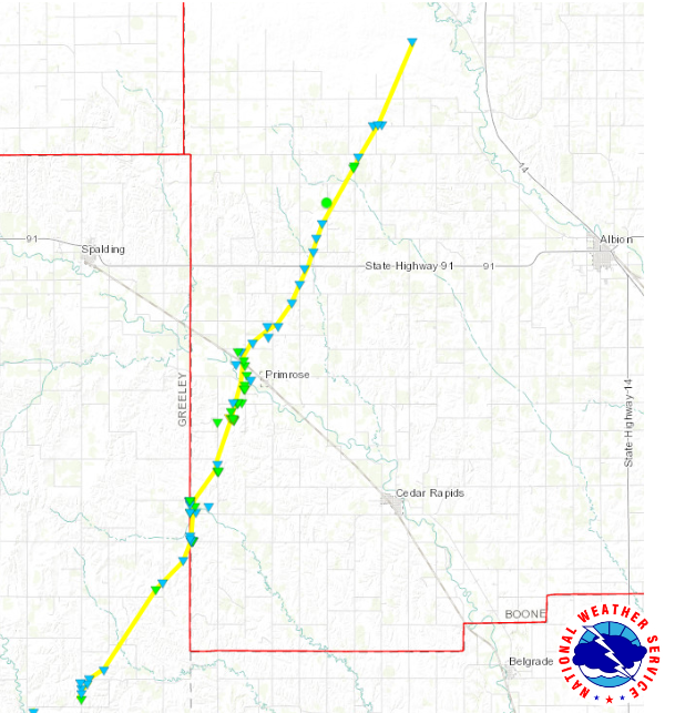
Downloadable KMZ File
The Enhanced Fujita (EF) Scale classifies tornadoes into the following categories:
Wind & Hail:
Add a written summary or simply an LSR map in this section. If writing an extensive report, you can break the report down into wind and hail below (otherwise delete).
Insert summary here.
Add a written summary if needed.
Hydrographs
Radar/Photos
Rain Reports
Insert rainfall reports here. Copy in PNS, paste rainfall map, or create table.
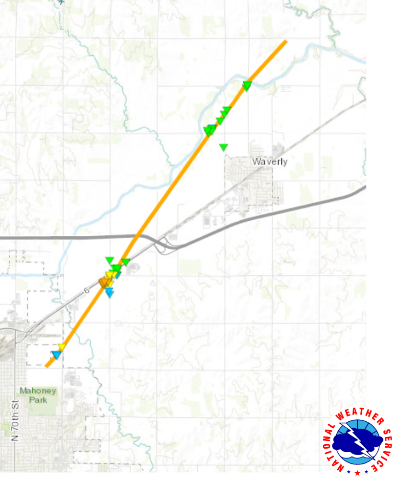
A vigorous low pressure system moving through Nebraska brought the necessary ingredients together for a severe weather outbreak across the region. In the mid levels of the atmosphere (15,000-20,000 ft above the ground), strong winds and cold temperatures overspread a warm, moist air mass streaming north from the Gulf of Mexico to create the necessary instability and vertical wind shear for severe thunderstorm development. The supercells that produced the tornadoes across eastern Nebraska and southwest Iowa developed along a Pacific front that extended south from an area of low pressure that moved from central into northeast Nebraska during the day.
Below is a model skew-T and hodograph that is a good representation of environment that the tornadic supercells were moving through.
Additional environmental data.
Additional Information
The Forecast
Warning Lead Time
Summaries from other NWS Offices
- NWS Des Moines
Warnings/Hazards Forecast Discussion Winter Weather Severe Weather Fire Weather Drought Storm Prediction Center SubmitReport
Current Conditions Current Observations
Rivers And Lakes River Forecasts Missouri River Overview Platte River Overview Elkhorn River Overview Ice Jam Risk
Local Information Latest Briefing Packet Weather Monitor Winter Monitor Preparedness Storm Spotters About Us Other Useful Links
US Dept of Commerce National Oceanic and Atmospheric Administration National Weather Service Omaha/Valley, NE 6707 North 288th Street Valley, NE 68064-9443 402-359-5166 Comments? Questions? Please Contact Us.

IMAGES
COMMENTS
Contact. Help. The ultimate road trip planner to help you discover extraordinary places, book hotels, and share itineraries all from the map.
Find curated trips across the USA for different lengths and regions, and customize your own trip with the USA Trip Planner. Explore extraordinary vistas, charming small towns, and hidden gems on the open road.
Hopefully our travel experiences will be of interest and benefit to website viewers as they plan their travel itineraries for 2024. The interactive map below highlights many of the more popular travel destinations in America, including national parks, scenic byways, historic sites, museums and favorite travel cities.
Photo: Wikimedia, CC0. The Midwest is known as "America's Heartland": the massive Great Lakes, the vast northwoods, wide-open plains full of corn and wheat, a patchwork of industrial cities and small towns, and one of America's greatest cities, Chicago. Chicago. Ohio. Illinois.
Find local businesses, view maps and get driving directions in Google Maps.
VisitTheUSA is the USA official guide for traveling the United States of America. Discover here all the information you need for your American holidays. ... The official travel site of the USA. Search Bookmarks Submenu. Destinations Trips Experiences Retract navigation. Search form. Global English Destinations Trips ... Map. Irresistible City ...
to the USA in seconds. Trending cities. Los Angeles. New York. Miami. San Francisco. Las Vegas. Chicago. Orlando. Boston. Create a day by day trip plan customized to you. Add Dates ... Make detailed travel plans in seconds. Create a unique, full day by day itinerary based on your preferences. Make it awesome.
Check out Manhattan Skyline, Central Park, and more. 2. Orlando. 40% as popular as New York City. Visit The Wizarding World of Harry Potter, Discovery Cove, and more. 3. Las Vegas. 37% as popular as New York City. Known for Fountains of Bellagio, Red Rock Canyon National Conservation Area, and more.
Whether you are a first-time visitor or returning to explore more of the USA, using the Visit USA interactive US State map provides a great way of exploring different destinations and understanding how they fit together. The possibilities are endless, from big cities and remote deserts to mountainous national parks, bargain-packed shopping outlets, palm-fringed coastlines and theme parks with ...
Browse our large selection of hundreds of United States folding travel maps. This section is divided into U.S. Travel Maps, Regional U.S. Travel Maps, U.S. State Travel Maps, and U.S. City Maps. Get your hands on the right map with the right detail for your next trip abroad. Use the search at the top-right of the website to find a map for a ...
Visited States Map; Select states you visited. States; Set map parameters Clear map & reset colors. Map width. Map height. Zoom function. Water. Visited states. Unvisited states. Hover states. Border. Hover border. Share your map on: Facebook Twitter. or on other networks: ... Contact Us. [email protected];
Keep exploring with the Roadtrippers mobile apps. Anything you plan or save automagically syncs with the apps, ready for you when you hit the road! Plan your next trip, find amazing places, and take fascinating detours with the #1 trip planner. Every trip is a road trip.
Do you want to know the safety and security situation of your travel destination? Check out the color coded map from the U.S. Department of State, which shows the level of risk for each country and region. You can also find detailed information and alerts for specific locations by clicking on the map. Plan your trip wisely and stay informed with the latest travel advisories.
This map was created by a user. Learn how to create your own. Popular vacation destinations across America, fantastic road trips on scenic byways, National Parks and travel ideas and ...
Map multiple locations, get transit/walking/driving directions, view live traffic conditions, plan trips, view satellite, aerial and street side imagery. Do more with Bing Maps.
The United States attractions map below show the top 10 attractions in 50 States. Click the map to explore the best travel spots in each State. Interactive 50 States Map of USA. Find out top attractions, vacation spots in each state at just one click of the map.
Road map. Detailed street map and route planner provided by Google. Find local businesses and nearby restaurants, see local traffic and road conditions. Use this map type to plan a road trip and to get driving directions in United States. Switch to a Google Earth view for the detailed virtual globe and 3D buildings in many major cities worldwide.
Official MapQuest website, find driving directions, maps, live traffic updates and road conditions. Find nearby businesses, restaurants and hotels. Explore!
Whether you need to plan a road trip, a commute, or a walk, MapQuest Directions can help you find the best route. You can customize your journey with multiple stops, avoid tolls and highways, and get live traffic and road conditions. You can also discover nearby attractions, restaurants and hotels with MapQuest Directions.
Step 2. Add a title for the map's legend and choose a label for each color group. Change the color for all states in a group by clicking on it. Drag the legend on the map to set its position or resize it. Use legend options to change its color, font, and more. Legend options...
× External Link. You are about to leave travel.state.gov for an external website that is not maintained by the U.S. Department of State. Links to external websites are provided as a convenience and should not be construed as an endorsement by the U.S. Department of State of the views or products contained therein.
This map is a testament to the geographical vastness of the United States. These are the lowest recorded temperatures (in Fahrenheit) for every state. It goes from 12 degrees to as low as -80 degrees.
Abortion travel escalated post-Roe. After the U.S. Supreme Court overturned Roe v. Wade and decades of federal abortion precedent in June 2022, decisions around the procedure and any limits or ...
Figure 3: Surface map at 7 PM on April 26th: Below is a model skew-T and hodograph that is a good representation of environment that the tornadic supercells were moving through. ... US Dept of Commerce National Oceanic and Atmospheric Administration National Weather Service Omaha/Valley, NE 6707 North 288th Street Valley, NE 68064-9443 402-359-5166
Receive up to 40% off available accommodation bookings in the U.S. including AK, HI, Puerto Rico & U.S. Virgin Islands and bookings for international travel. Discount is applied to price of room before taxes and any fees, including additional fees collected by the property at check-in. Reservations can only be made up to eleven months in ...