- Skip to right header navigation
- Skip to main content
- Skip to primary sidebar
- Skip to footer
- Trip Planner


9 Best Motorcycle Rides in Colorado
March 19, 2023 By // by William Reavis
Home to 26 scenic byways, Colorado is one of the best states to explore on a motorcycle. Take white-knuckle rides with hairpin turns and steep drops, as well as serene spins through rolling grasslands.
Our selection of the state’s best two-wheel rides combines fantastic views, high-quality roads , and easy access to amenities and activities.
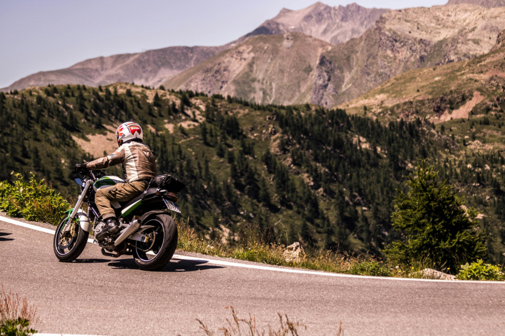
Cache La Poudre-North Park Scenic Byway

Connecting the towns of Fort Collins and Walden, the Cache La Poudre-North Park Scenic Byway winds along the beautiful Cache La Poudre River through the Roosevelt National Forest. Along the way, enjoy the views from the 10,276 foot summit of Cameron Pass, and consider stopping at any number of great fishing and hiking spots throughout the journey. The entire route is paved and gently winding, making it ideal for motorcyclists.
For those starting the ride from the east, be sure to spend some time checking out Fort Collins. Visitors can find a vibrant downtown full of restaurants, craft breweries, bars, and galleries, along with the sprawling Colorado State University campus.
On the west side of the byway, don’t skip out on exploring the North Park area of the Centennial State. Known as the Moose Viewing Capital of the state, State Forest State Park is a great spot to visit for a good chance at seeing moose and other wildlife.
Length: 101 miles | Fort Collins—Walden
Grand Mesa National Scenic Byway

Spanning 63 paved miles between Mesa and Cedaredge, the Grand Mesa National Scenic Byway offers riders a chance to explore Grand Mesa, which is known as the largest flat-top mountain in the world. The route rises to around 11,000 feet at its highest point, and it passes within easy hiking distance of countless alpine lakes for some peaceful fishing.
It is not part of the official itinerary, but many visitors choose to tack on an additional 14-mile one-way trip to Lands End , where expansive views and a small observatory await. Though the main byway is entirely paved, motorcyclists should keep in mind that this addition is only partially paved and known to have lots of potholes.
Dispersed and paid campsites are available throughout the scenic journey. At the northern end, Mesa is a small town with limited options for accommodations and food, but Cedaredge at the southern terminus has ample hotels, bars, and restaurants. While passing through Cedaredge, consider paying a visit to The Pondy, a local dive bar with pool tables and a jukebox.
Length: 63 miles | Mesa—Cedaredge
Mount Evans Byway

The highest paved road in North America, the Mount Evans Byway winds its way above 14,000 feet starting in Idaho Springs. The road is free to drive, but there is a per-vehicle fee for parking at the summit. Though the road to the top is paved, it features hairpin turns, sheer cliffs without guardrails, and limited smooth pull-offs, making it a good choice only for experienced motorcyclists.
On the way to the top, consider stopping at Echo Lake Park or Summit Lake Park, both of which are home to picturesque lakes. Summit Lake Park is located just before the last push to the peak, making it a great place to stretch your legs before embarking on the final ascent toward Mount Evans.
Bikers looking for a longer adventure should try out a detour to Evergreen via Mestaa’Ėhehe Pass . First established in 1923, this fully-paved road is a popular addition to trips to Mount Evans. In Evergreen, stop for a drink or snack at Bivouac Coffee, a local coffee shop owned and frequented by motorcycle riders.
Length: 28 miles | Idaho Springs
Peak to Peak Byway

Colorado’s oldest scenic byway, the Peak to Peak Byway runs from Estes Park in the north to the casino towns of Central City and Black Hawk in the south. Known as “the showcase of the Front Range,” this route is easily accessed from Denver , making it an ideal weekend trip for riders of all skill levels. At 59 miles, this adventure can be finished in a couple of hours, but many choose to take their time and explore along the way.
Though open year-round, the Peak to Peak Byway is well known for beautiful views of foliage during autumn. Riders will pass through the quaint town of Nederland, where accommodations, bars, and plenty of good food can be found.
Activities along the way include fishing, hiking, and exploring any number of dirt roads that branch off from the main byway. Additionally, many visitors enjoy exploring the ghost towns of Apex and Nevadaville near Central City. In Black Hawk, be sure to stop for a bite to eat at The Last Shot, a family restaurant with dedicated motorcycle parking.
Length: 59 miles | Black Hawk—Estes Park
Pikes Peak Highway

The highest toll road in North America, the highway to “America’s Mountain” makes a worthy addition to any motorcycle rider’s Colorado itinerary. Sitting at 14,115 feet, Pikes Peak is one of the most notable mountains on the continent. It’s easy to access from Colorado Springs, and the views from the top are hard to forget.
As expected, the Pikes Peak Highway is not for novices. With sharp turns and frequent drop-offs without guardrails, riders should be comfortable making tight, exposed turns before attempting this route. Though the whole road can be nerve-wracking, the most difficult part begins after the road ascends above the treeline.
From the Summit Complex parking lot, walk the few steps necessary to the true summit of the mountain. After taking in the breathtaking view, head inside the newly-renovated visitor center for interpretive signage and a bite to eat. The mountain is known for its famous donuts, but burritos, soups, and sandwiches are also available.
To avoid crowds, opt for a weekday trip to Pikes Peak, and always plan to start your adventure early. Summer is known for bringing frequent afternoon storms in the state, so a morning start is safer, more enjoyable, and less crowded.
Length: 19 miles | by Colorado Springs
San Juan Skyway National Scenic Byway

Passing through the towns of Durango, Telluride, and Silverton, among others, the San Juan Skyway National Scenic Byway is one of the premier byways in the state. Spanning over 200 miles in length with plenty of camping and hotels located throughout, this route makes a perfect multi-day ride for motorcyclists looking for fantastic natural beauty and rich historical sites.
One of the highlights of the trip is the Million Dollar Highway . Running for 25 miles between Ouray and Silverton, this stretch of the road has some of the best views that Colorado has to offer. This section weaves across the Uncompahgre Gorge to the top of Red Mountain Pass. It showcases thrilling cliffsides, gorgeous fall foliage, and numerous scenic overlooks.
Along the byway, riders can stop for fishing, world-class hiking, and near-limitless exploration. Popular spots along the way include Ridgway State Park and Mancos State Park . In Durango, consider spending the extra time to check out the Durango and Silverton Narrow Gauge Railroad, and be sure to stop by for a drink at the Million Dollar Highway Saloon before leaving town.
Length: 233 miles | Telluride—Durango
Santa Fe Trail Scenic Byway

Roughly following the original path of the historic Santa Fe Trail, the Santa Fe Trail Byway travels for 188 miles between the towns of Lamar and Trinidad in southeastern Colorado. Though not high in the mountains like most of the rides on this list, this serene route through the grasslands is a good addition to any itinerary with a few ghost towns along the way.
It can be ridden in either direction, but going from east to west gives riders the best views of the stunning Sangre de Cristo mountains. Loosely following the Arkansas River, the byway heads southwest from Lamar, passing through Las Animas. In this area, it’s a great idea to stop at John Martin Reservoir State Park for a look at the second-largest body of water in the state.
Further along, enjoy views of the Comanche National Grassland which is full of falcons, antelope, and beautiful fields of sunflowers in late summer. By the time the route reaches Trinidad at right around 6,000 feet, it has gained over 2,000 feet in elevation. From here, the historic Santa Fe Trail continues south, passing into New Mexico and over Raton Pass.
Length: 188 miles | La Junta
Trail Ridge Road Scenic Byway

Located within the Rocky Mountain National Park, Trail Ridge Road Scenic Byway is an iconic Centennial State excursion. First opened in 1938, Trail Ridge Road connects Estes Park and Grand Lake, and has a peak elevation of 12,183 feet. Like many other high-elevation byways in the state, the road is open only during the summer months, and it typically opens up around Memorial Day each year.
There are no guardrails throughout the route, and the drop-offs can be steep, so stay alert throughout the journey. The entire byway is situated within the national park and the speed limit is quite low and definitely enforced. Additionally, traffic often backs up on this famous ride, so start early for the best chance at a solitary experience.
Along the way, stop at any number of scenic overlooks for jaw-dropping views of the mountains. The overlook at Fairview Curve is one of the most frequented, and it offers great vistas of the Never Summer Mountains. Trail Ridge Road is the perfect place for wildlife enthusiasts, as elk, moose, marmots, bears, and much more frequent the areas near the road.
On either end of the byway, both Estes Park and Grand Lake have plenty to see and explore. A number of popular bars and saloons can be found throughout downtown Estes park, including Wheel Bar and Lonigans Saloon. Grand Lake is a smaller town, but nonetheless, there is still plenty to eat and drink along Grand Avenue.
Length: 48 miles | Estes Park—Grand Lake
Top of the Rockies Byway

Navigating 115 miles between Copper Mountain, Aspen, and Minturn, the Top of the Rockies Byway passes through some of the state’s most remarkable areas. Crossing the Continental Divide multiple times, this byway barely dips below 9,000 feet and features striking views of both Mt. Elbert and Mt. Massive.
Beginning in Aspen, one of Colorado’s most famous ski towns, the route heads west and crosses its high point on Independence Pass at 12,095 feet. From here, the byway passes through Twin Lakes, a small town that provides excellent access to hiking and camping near Mt. Elbert.
The approximate center of the journey is Leadville, which is America’s highest incorporated town. Heading north from here, riders can choose to take one of two branches of the route. Staying on US-Highway 24 over Tennessee Pass ends up in Minturn, while branching off to Colorado Highway 91 leads to Copper Mountain.
One popular stop along the ride is Camp Hale Memorial , a former World War II training ground where soldiers trained to fight in the mountains of Italy. In total, the Top of the Rockies Byway passes through the Pike, San Isabel, and White River National Forests, and it provides unforgettable views, great riding, and world-class access to the backcountry.
Length: 115 miles | Aspen—Copper Mountain
Hopefully, this list has inspired you to start planning your next motorcycle adventure and see all that colorful Colorado has to offer. Enjoy your trip!

About William Reavis
William is a student studying English at Boston University. When he's not writing, he's an avid backpacker and reader.
Join our Colorado travel community

Get In Touch
- Privacy Policy
- Disclaimer—Terms of Service
Things To Do
- Travel Blog
- Colorado Activities
- Colorado Events
- Colorado Towns
- Colorado Hotels
- Colorado Restaurants
- Colorado Transportation
- Made in Colorado
Fall Activities
- Federal Lands
- Ghost Towns
- Hot Springs
- Ski Resorts
- State Parks
- Train Rides
10 Best Motorcycle Roads In Colorado +Maps [Ride-Rate-Review]
Riding past the “Welcome to Colorful Colorado” sign seems to present the most amazing motorcycle touring roads as if they were a feast on a golden platter.
As an avid motorcyclist it’s easy to appreciate the beauty in each state and for many riders seeking out amazing roads that most would overlook can become second nature, even an art form some may say. Throughout our vast and beautiful country called The United States of America, we are fortunate enough to have a plethora of both paved and dirt roads that are meant to be sought out like the Ark of the covenant. These roads are meant to be experienced intimately, the only way they can be, on 2 wheels.
Experiencing these beautiful thruways on a motorcycle can become a thirst that is never quenched, and although each state has its own unique characteristics ultimately some will stand out more than others. One state that has that effect for motorcyclists is Colorado.
Colorado is one of those states that as soon as you ride past the “Welcome to Colorful Colorado” sign the roads seem to present themselves to you like a feast on a golden platter with an endless amount of wine.
The rides we will be reviewing in this forum can be completed in 1-2 days and are best ridden between late April and early October.
Best Motorcycle Roads In Southern Colorado
Southern Colorado is a rider’s paradise and a region that should not be missed for riders of all experience levels. Other avid motorcyclists have also recommended these roads to me, which reinforces my recommendations for these routes and motivated me to write this comprehensive layout to help others. I hope this breakout has proves to be helpful and serves as a reason to visit Southern Colorado and have the riding experience of a lifetime.
MILLION DOLLAR HIGHWAY RTE. 550
Start – finish.
Cortez – Rico
Ride Distance
Suggested time.
This loop may be one of the greatest roads in all of North America. The road is paved and in immaculate condition. It combines some of the tightest switchbacks one can expect to experience on a motorcycle. The full route per the map is ~235 miles and can be done in 1 day, but highly recommend taking at least 2-4 to fully experience and immerse yourself in this beautiful part of the country.
There are endless forest roads off this to get your fill of dirt riding littered with an infinite amount of beautiful dispersed campsites. Some wonderful old mining towns rich with history, hiking, restaurants, hotels, and hot springs pave the way forward to this adventure.
Emergency Contact
San Juan County Sheriff (970) 387-5531
There is no shortage of amazing places to stop along the way. Below is a small list of the places you should not miss along this route.
- Silverton – Great little mining town with wonderful people. A perfect place to load up on supplies if you are camping or to warm up after getting some miles in at the Brown Bear Café.
- Ouray – Beautiful mountain town with several hikes to waterfalls, hot springs, and some wonderful restaurants. My favorite is the Ouray Brewery .
- Rico – This is a really tiny town which consists of a great hotel and bar called The Enterprise Bar and Grill . Wonderful people with some great food and cold beer.
There is an immense amount of national forest land that can be used to camp on along this loop. Really any dirt road you ride down will guide you to an epic campsite next to a creek that makes for a relaxing post ride spot to wind down in a hammock, while having a refreshing beverage.
The towns of Silverton and Ouray have several hotels that are right in the heart of the town and a short walk to tourist activities and restaurants. If you prefer to stay in a town to experience the wonderful atmosphere and people in this area.
There is no shortage of dirt roads to find here, this goes from flat well-groomed forest roads to the technical challenging mountain passes like Engineer or Imogene Pass (which I have not done due to the size of my GS1200 and conservative riding style).
Out of so many outstanding rides in the state of Colorado, Rte. 550, The Million Dollar Highway should be on the top of any motorcyclists list. This road and area really earns that 5 wheelie rating due to exceeding each standard for riders of all skill levels.
There are so many sights to see along this route that you will never tire of absorbing the beauty that surrounds you in this part of the state. If you are fortunate enough to have the time – doing the loop in reverse can be a great way to add a few more days to your adventure.
This is one of the drawbacks of listing this in a National Park as there is no off-roading permitted within the park boundaries. The beauty and activities from hiking and riding makes up for this shortcoming.
MESA VERDE NATIONAL PARK
Visitor Center – Cliff Palace

Be prepared for the sense of overwhelming vertigo as soon as you enter the National Park and the road begins screaming up in elevation with incredible views overlooking the valley below. A wonderful feeling as the path goes on and on as you travel through the park.
Although the distance from the park entrance to the furthest point is only 28 miles, those miles are filled with numerous overlooks and pullouts that can make this seemingly short ride take 2-3 days. This is especially true if you are taking in the hikes along the way.
The only piece of concern for this ride is the numerous road snakes in some areas of this ride. Otherwise its full enjoyment as you have a 360 view of the valleys below that outstretch clear into Utah, New Mexico, and Arizona.
(970) 529-4465
Since this is a National Park there are ample amounts of short hikes and tours to break up the day(s) you spend in this magical location. A few of the more popular ones are outlined below:
- Mesa Verde National Park
- Cliff Palace – This requires purchasing a tour ticket at Park Visitor Center, but even without one you can walk to the overlook to get a spectacular view of the houses the Hopi built into the cliffs which are all but hidden except from this vantage point
- Balcony House – This also requires a tour ticket but is well worth it as you can walk through the ruins and really get a sense of the majestic surroundings.
- Knifes Edge Hike – A great 2 mile hike with little elevation next to Morfield Campground which has incredible sunset views that enable the rocks to really light up and glow like you’ve never seen before.
Morfield Campground- This is the only campground in the park so making reservations ahead of time is recommended. It is one of the better National Park campgrounds I have stayed at and includes free showers, great WiFi from most campsites (antennas are off the bathrooms), and a launderette, gas, and fully stocked store for all your camping and souvenir needs.
There are also several wonderful hiking trails to hike right next to the campground if you choose to get some exercise in closer to camp at the end of the day where deer are plentiful as you enjoy winding down in the evening.
GRAND MESA SCENIC BYWAY- RTE 65
Cedar Edge – Lands End Observatory
~50 – 100 Miles
A beautiful Colorado mountain road filled with switchbacks that rise in elevation and bring you up to over 10,000 feet and onto the World’s largest Mesa. There are several pullouts along this route to take in the views, but no gas stations from Cedaredge to Mesa (50 miles, but can be close to 100 miles if you are doing the off-road portion) so plan accordingly.
Mesa County Sheriff (970) 242-6707
The main point of interest the mesa itself and the amazing views, alpine lakes, dispersed camping, and off-roading. Grand Mesa, Alpine Lakes, Lands End Observatory, Surface Creek Road
- Lands’ End Observatory – Well worth a 10 mile off-road ride to get to this viewpoint.
- Wagon Wheel Restaurant and Motel – A great place to stop for a beverage and a burger for lunch, charge your equipment and take a breather.
Dispersed camping is plentiful along Rte125 where you can get a lakeside campsite with little issue and make it your own paradise for the evening as you watch the sunset glistening off one of the many alpine lakes.
There are also plenty of campgrounds along the way if you are looking for less primitive camping. Hotels are scattered along this route in the towns of Delta, Mesa, or driving to up Grand Junction for a greater variety of lodging.
Rte125 Surface Creek Road is a great 15 mile loop. This road has you experience the mesa while passing crystal clear alpine lakes with numerous dispersed camping areas. There is also a 10 mile dirt road in great condition to visit the Lands’ End Observatory. The views off the mesa looking down on the plateau will allow you to see into Utah on a clear day with awe inspiring views.
GRAND JUNCTION TO NATURITA RTE 141
Grand Junction – Naturita

A 105 mile long, low elevation beautifully paved road which will have you leaning your ride until you feel the mist kissing your windshield from Dolores River as you pass amazing rust colored mesas that stretch into the sky and rival that of Monument Valley.
The road has very little traffic which will allow you to enjoy some solitude as you embrace the scenery you ride through. The only minor drawback on this route is the lack of amenities so come more prepared than you usually would.
Montrose County Sheriff (970) 864-7333
This stretch of road is in quite a desolate area outside the tiny town of Gateway. Gateway Canyons General Store is owned and run by the preacher of the church next door to it. This is the only place to gas up between Grand Junction and Naturita so be sure to check your fuel levels. Be sure to check out Dolores River, Divide Road (Off-road)
Dispersed camping here is plentiful but mainly in one area just south of Grand Junction, Divide Road. This road is a steep switchback dirt road that connects to numerous other roads which are great fun exploring for campsites or campgrounds to settle down in. There are numerous dispersed sites with beautiful views over the canyon in which you can see the Dolores River running far beneath you.
Divide Road also encompasses numerous off-roading opportunities that sprawl out across this mesa. This is a perfect place to explore for that unique dispersed campsite while hitting some fun dirt trails to enhance your day. There are however areas of slippery clay, so if it is raining or has been, it can make it a bit slick in portions of these roads.Lake City is the takeoff point for some of the more serious off-roading mountain passes. A few of the most popular passes begin there including Cinnamon and Engineer passes. Both surpass 12,000 Ft in Elevation. These are some of the best passes in Colorado and if you are craving technical off-roading challenges with views that can’t be beat these are the two I recommend.
PAGOSA SPRINGS – LAKE CITY RTE 160, 149
Lake City – Pagosa

This route consists of 45 miles of 4 lane highway on Rte 160 that summits at over 10,000 Ft which then drops you into South Fork, CO where you will turn left onto Rte 149. Rte 149 will quickly whittle down to a tighter quieter 75 miles of mountain passes. South Fork is the only town between these areas so ensure you gas up , get lunch before heading onto the second part of this amazing road that will have you speeding across lower elevation prairies and then climbing high into the mountain tundra that will resemble something from another planet.
Archuleta County Sheriff (970) 264-8430
I specifically wanted this trip to begin (or end) in Pagosa Springs so you have an opportunity to experience the hot springs in Pagosa.
There are free hot springs you can visit called Hippy Dippy Hot Springs, but I highly recommend taking an afternoon and enjoying the springs at the Pagosa Springs Resort .
Mountain Pizza is the perfect place for a great pizza prior to starting on the 2 nd part of this ride in South Fork.
Rio Grande National Forest is a great spot to stop and stretch with views of magnificent waterfalls along Rte149

Throughout the ride there is no shortage of camping both dispersed and paid locations. In Pagosa there are numerous hotels to stay in. I prefer this hotel directly across the street from the spa as it is much more affordable then the spa and in a great location.
For Lake City, the Matterhorn is a beautiful Swiss style motel which will allow you a solid night’s sleep at a great price. It’s a perfect spot to recharge if you are going to take on some of the more challenging off-road portions in Colorado the following day.
Lake City is the takeoff point for some of the more serious off-roading mountain passes. A few of the most popular passes begin there including Cinnamon and Engineer passes. Both surpass 12,000 Ft in Elevation. These are some of the best passes in Colorado and if you are craving technical off-roading challenges with views that can’t be beat these are the two I recommend.
Best Motorcycle Roads In Northern Colorado
Ride In Progress – July 2021
Check out the best motorcycle road trips in California

Hi! I'm Wes, the rider and writer behind First Checkpoint. I spend most of my week days curating content for my fellow two wheel enthusiasts and I spend my weekends just like the rest of you... burning rubber somewhere far away from home. #Braap !!
Drop a comment below! Even if it's just to say hi :)
Leave a Reply Cancel reply
Your email address will not be published. Required fields are marked *
Top 10 Best Motorcycle Rides in Colorado: My Ultimate Guide
The Centennial State offers a diverse terrain for motorcyclists of all levels, including high-altitude adventures that sweep through the Rocky Mountains and leisurely cruises along the Eastern Plains. There’s truly something for everyone in Colorado, with each ride bringing its own unique thrill and unmistakable scenery.
For riders keen on discovering more, neighboring states like New Mexico showcase a blend of desert and mountain rides that feature historic pueblos and vast expanses of wilderness. And to the north, Wyoming’s Beartooth Highway offers an unforgettable journey through high-altitude passes and stunning views of the Rocky Mountains.
I’ve explored the vast and magnificent landscapes of Colorado to bring you the top 10 best motorcycle rides in the state. These routes stand out for their natural beauty, curves, and thrilling open roads. Strap on your helmet and get ready to discover the wonders of Colorado, from steep mountain passes to picturesque valleys.
1. The San Juan Skyway

As a top contender in Colorado motorcycle rides, the San Juan Skyway offers riders stunning views and exciting twists and turns. With its varying elevations and picturesque landscapes, it’s no wonder that this route is regarded as one of the most scenic rides in the state.
Best Time to Visit : The ideal time to explore this route is from late May to early October . During these months, the weather conditions are most suitable for taking to the road on a motorcycle.
Distance and Time to Travel : Spanning approximately 232 miles in length, the San Juan Skyway can take anywhere from 4 to 6 hours to complete, depending on the stops one makes and the overall pace. It’s worth taking the time to fully experience the beauty that this route has to offer.
Places to Stop : The San Juan Skyway has numerous stops worth exploring:
- Durango : A historic town with a rich cultural history and plenty of amenities
- Silverton : A quaint village that showcases Colorado’s mining heritage
- Ouray : Known as the “Switzerland of America,” Ouray offers beautiful mountain scenery and relaxing hot springs
- Telluride : A popular destination for outdoor enthusiasts, featuring a classic western feel intermingled with modern amenities
Level of Difficulty : The ride is considered moderate in difficulty, with some elevation changes and tight turns. It’s suitable for most experienced riders, but beginners may want to tackle easier routes first.
Keep the following details in mind:
- Be prepared for changes in weather conditions, as the high elevation can cause sudden shifts
- Keep an eye out for wildlife, particularly in more remote stretches of the route
- Be mindful of altitude sickness, and plan accordingly – allowing a day or two to acclimate to the elevation can provide a safer and more enjoyable ride
2. The Peak Highway

The Peak to Peak Highway in Colorado is a scenic and adventurous route that I highly recommend for motorcycle enthusiasts. This highway offers stunning views of the Rocky Mountains, lush forests, and various picturesque towns along the way. It’s a favorite among locals and visitors alike.
Best Time to Visit : The ideal time to ride the Peak to Peak Highway is during late spring, summer, and early fall when the temperatures are just right. With the unpredictable Colorado weather, it’s crucial to check the forecast before hitting the road.
Distance and Time to Travel : This scenic byway stretches for about 55 miles and takes roughly 2 to 3 hours to complete, depending on your pace and stops. The journey starts in the town of Black Hawk and ends in Estes Park.
Places to Stop : Make sure to take time to explore the following points of interest during your ride:
- Nederland : A charming mountain town with an array of shops, restaurants, and cafes.
- Golden Gate Canyon State Park : A beautiful park that offers hiking trails and picnicking areas.
- Rocky Mountain National Park : A must-visit spot for outdoor enthusiasts. Entry to the park requires a fee.
Level of Difficulty : The Peak to Peak Highway is considered a moderate level of difficulty. The road is well-maintained with a few twists and turns, but nothing too extreme. However, it’s essential to watch for wildlife and be cautious on blind corners.
- Ensure your motorcycle is in excellent condition, as there are limited places along the route to stop for repairs.
- Pack extra layers and rain gear, as weather can change quickly in the mountains.
- Be cautious when riding through town centers, as there might be significant traffic during tourist seasons.
- If you don’t have your own motorcycle, there’s a motorcycle rental in Denver that you can use.
3. The Grand Mesa Scenic Byway

One of my personal favorite motorcycling routes in Colorado is The Grand Mesa Scenic Byway . This incredible ride offers breathtaking views and diverse landscapes, from dense forests to shimmering lakes. The scenic road stretches for 63 miles along the Grand Mesa, the world’s largest flat-topped mountain.
Best Time to Visit : The ideal time to experience the Grand Mesa Scenic Byway is from June through September. During these months, weather conditions are typically mild, and the surrounding landscapes burst into vibrant shades of green.
Distance and Time to Travel : The route is approximately 63 miles long, and it’ll take you about 2 hours to complete, depending on your speed and the number of stops you make to enjoy the spectacular views.
Places to Stop : Along the journey, you’ll find several points of interest to stop and explore, such as:
- Island Lake : A picturesque alpine lake surrounded by towering pines. Perfect for a picnic or a refreshing swim.
- Land’s End Observatory : At the western edge of the Grand Mesa, this observatory offers panoramic views of the surrounding valleys and mesas.
- Powderhorn Mountain Resort : If you’re visiting during the winter months, this ski area caters to both skiers and snowboarders of various skill levels.
Level of Difficulty : With well-maintained roads and a mix of gentle curves, steep climbs, and thrilling descents, the Grand Mesa Scenic Byway is suitable for riders of all skill levels. Novice riders should take extra caution, especially on the narrower sections of the byway.
When planning your ride, keep the following in mind:
- Due to its high elevation (over 10,000 feet), the temperature can drop rapidly as you ascend the mountain. Don’t forget to carry appropriate gear and layered clothing to stay warm.
- Cell phone reception might be sparse in some areas, so it’s wise to carry a printed map or GPS for navigation.
- Wildlife, such as deer and elk, can often be spotted near the byway. Stay vigilant to avoid surprises and potential hazards.
4. Independence Pass Adventure

If you’re seeking a thrilling motorcycle ride with jaw-dropping views, I highly recommend the Independence Pass Adventure . Snaking through Colorado’s Rocky Mountains, this scenic route promises an unforgettable experience for avid motorcyclists.
Best Time to Visit : The ideal time to embark on this adventure is late spring to fall, typically between May and October . During these months, the road is clear of snow, the weather is predictably pleasant, and the vibrant colors of nature are on full display.
Distance and Time to Travel
Independence Pass stretches for 82 miles (131 kilometers) and takes approximately 2 to 3 hours to cover, depending on riding speeds and stops. Riders can get ready for an adrenaline-pumping experience with steep grades and sharp turns.
Places to Stop ; As you journey along Independence Pass, you’ll come across fantastic spots for breaks and photo opportunities. Some noteworthy places include:
- Twin Lakes Village: A quaint lakeside town for stocking up on snacks, fueling up, and stretching your legs.
- The Town of Aspen: Offering dining, shopping and a chance to explore this world-famous mountain destination.
- Grottos Trail: A short hike leading to beautiful geological formations and cascading waterfalls.
Level of Difficulty : Independence Pass is characterized as a moderately challenging route, ideal for experienced riders. The ride entails navigating hairpin turns, steep inclines, and potential for wildlife encounters. Therefore, it’s essential to remain alert and cautious.
Before embarking on your Independence Pass adventure, it’s crucial to keep some key points in mind:
- The elevation at the summit reaches 12,095 feet , so be prepared for altitude changes and possible temperature fluctuations.
- Gas stations can be scarce; make sure to fuel up whenever possible.
- Roads may be narrow and without guardrails in certain areas; exercise caution and ride safely.
5. Rocky Mountain National Park Loop

This scenic ride is one of the most iconic motorcycle trips in Colorado. With its majestic mountain views, winding roads, and breathtaking landscapes, it’s an experience that will leave you craving more.
Best Time to Visit: Typically, the prime time to enjoy this ride is between June and October, when the weather is most favorable. However, always check current road conditions and closures before embarking to avoid any surprises.
Distance and Time to Travel: The Rocky Mountain National Park Loop covers roughly 228 miles and takes about 6 hours to complete at a moderately relaxed pace.
Places to Stop: There’s no shortage of sightseeing opportunities and pit stops along the way, some of the most notable being:
- Estes Park: This picturesque mountain town is a great place to grab a bite, shop for souvenirs, or take a detour to the iconic Stanley Hotel.
- Trail Ridge Road: As the highest continuous paved road in the United States, the stunning views and wildlife sightings make this a can’t-miss part of the ride.
- Grand Lake: Offering a variety of amenities, lodgings, and outdoor activities, Grand Lake is an ideal stop to unwind and enjoy the tranquil lake scenery after a long day of riding.
Level of Difficulty: Generally considered an intermediate ride, it’s important to be aware of the changing elevation, switchbacks, and occasional traffic congestion, particularly in peak season. Riders should also be prepared for rapid weather changes as they traverse the high-altitude terrain.
It’s worth noting that there’s an entrance fee for Rocky Mountain National Park. However, one-time entry passes or annual parks passes offer a cost-effective solution for avid riders and adventurers alike. In addition, while cell service can be spotty in remote areas, there are a few visitor centers along the route to acquire any needed information or assistance.
6. Trail Ridge Road

Trail Ridge Road is undoubtedly one of my favorite motorcycle rides in Colorado. Located in Rocky Mountain National Park, this route treats riders to stunning panoramic views, exhilarating twists and turns, and pristine alpine landscapes. Before diving into the details of this spectacular ride, let’s take a quick look at its overall characteristics:
The best time to visit Trail Ridge Road is between May to October . It’s important to note that this road may close unexpectedly due to hazardous weather conditions like snow and ice, especially during early or late season, so always check the National Park Service website for updates.
Covering a distance of approximately 48 miles (77 kilometers), it takes about 2-3 hours to complete the ride. However, don’t forget to budget extra time for stops to capture photos and take in the breathtaking views. And trust me, there are plenty of those along the way.
I highly recommend making stops at Estes Park and the Alpine Visitor Center . Estes Park is often considered the gateway to Rocky Mountain National Park and offers excellent dining, lodging, and shopping options. The Alpine Visitor Center serves as the highest visitor center in the entire National Park System and provides restroom facilities, an informative exhibit hall, a gift shop, and a café.
In terms of difficulty, I’d classify Trail Ridge Road as a moderate ride. While it includes several tight curves and steep inclines, the road itself is paved and well-maintained. That being said, always exercise caution and obey posted speed limits, particularly when navigating the higher altitude portions of the route.
Lastly, it’s important to mention that there is an entrance fee required to access Trail Ridge Road within Rocky Mountain National Park. Fees vary depending on the type of pass purchased, so visit the National Park Service website for pricing details.
7. The Million Dollar Highway

As one of the most breathtaking and picturesque routes in all of Colorado, the Million Dollar Highway checks all the boxes for an unforgettable motorcycle ride. This legendary stretch of road lies within the spectacular San Juan Mountains and offers riders unbeatable views, exhilarating curves, and a true experience of the great outdoors.
Best Time to Visit: Midsummer or early autumn are the best times for a ride on the Million Dollar Highway. During these seasons, you’ll be met with the stunning contrast between the vibrant colors of the surrounding trees and snow-capped peaks, as well as more agreeable weather for a motorcycle trip. Although beautiful, the higher elevations can be tricky to navigate during winter months due to snow and ice on the roads.
Distance with Time to Travel: This scenic route covers approximately 70 miles (112 km) , stretching from Silverton to Ouray. With plenty of twists, turns, and scenery to capture your attention, it’s recommended to give yourself about 2 to 3 hours for the entire ride. This will allow ample time to stop and take in the views or snap some photos along the way.
Places to Stop:
- Silverton : The ride begins at this historic mining town that’s now home to a tight-knit community and various attractions.
- Red Mountain Pass : At 11,018 feet elevation, it’s a perfect spot for a photo op with a jaw-dropping panorama.
- Ouray : Known as the “Switzerland of America”, this small town offers a charming end to the ride, with picturesque scenery and soothing hot springs.
Level of Difficulty: The Million Dollar Highway is considered moderate to challenging . There are a few steep drop-offs and tight curves without guardrails, which can be intimidating for some riders. However, if you take your time and ride with caution, it’s an enjoyable journey for experienced motorcyclists.
It’s important to pack extra layers for the ride, as the higher elevations can have cooler temperatures even in the summer months. You’ll also want to ensure your motorcycle is in good condition before tackling this route, as you don’t want to break down in a remote area.
8. The Royal Gorge

One of my favorite motorcycle rides in Colorado has to be riding through the Royal Gorge . It’s a breathtaking experience that offers a mix of stunning natural beauty, thrilling curves, and some of the state’s most iconic landmarks. Here’s everything you need to know about this incredible ride.
Best Time to Visit : While the Royal Gorge is accessible year-round, the best time to visit is during late spring through early fall. This is because the weather is typically mild and dry, which makes for optimal riding conditions. Keep in mind that the higher elevations can still be chilly, so it’s a good idea to dress in layers.
Distance and Time to Travel : The ride from Canon City through the Royal Gorge encompassing the loop is around 50 miles long . Given the winding roads, varying speeds, and stopping points, it usually takes about 2 to 3 hours to complete the journey. Of course, the actual time taken will depend on your personal riding pace and how often you choose to stop.
Places to Stop : The route is filled with several amazing places to stop and take in the surroundings. Some of these include:
- Skyline Drive : This scenic drive offers panoramic views of Canon City and the surrounding area.
- Royal Gorge Bridge : A must-visit, this impressive suspension bridge is one of the highest in the United States and provides spectacular views of the gorge below.
- Royal Gorge Park : Home to a visitor center, picnic areas, and an aerial tram, this park is an ideal place to take a break and enjoy the scenery.
Level of Difficulty : The Royal Gorge ride is moderate in difficulty , with several twists and turns that will require your full attention. However, it’s not overly challenging, making it suitable for riders of various skill levels. Just be sure to remain cautious around blind turns and always respect the posted speed limits.
A few more things to be aware of when planning your ride through the Royal Gorge are:
- The road can sometimes have gravel or debris, so it’s crucial to be vigilant and maintain a steady pace.
- Gas stations and restaurants are limited along the route, so it’s wise to fuel up and grab some snacks before starting your ride.
- Cellular reception can be spotty in certain areas, so make sure to carry a map or GPS device for navigation purposes.
9. Highway 50: The Lifeblood of America

I have to admit, there’s something incredibly special about Highway 50 in Colorado. Often referred to as the “Lifeblood of America,” this scenic route offers a one-of-a-kind motorcycle experience that is truly unforgettable. With a variety of terrains, stunning vistas, and interesting pit stops along the way, this ride should definitely be on your Colorado motorcycle adventure list.
Best Time to Visit : The ideal time to explore Highway 50 on a motorcycle is between May and September . During this period, the weather is mild, and the road conditions are favorable for a smooth ride. Keep in mind that Colorado weather can be unpredictable, so it’s essential to stay updated on the latest forecasts and road conditions before you hit the road.
Distance and Time to Travel : Highway 50 in Colorado stretches for about 306 miles from east to west. Depending on your speed and the number of stops you make, you can expect to spend anywhere from 5 to 8 hours traveling this iconic route.
Places to Stop : There are several must-see spots to visit as you cruise along Highway 50, including:
- Royal Gorge Bridge and Park : This historic bridge stretches across a stunning canyon and offers a wide array of adrenalin-pumping activities.
- Black Canyon of the Gunnison National Park : Showcasing incredible geological formations and dramatic views, this national park is a must-visit destination.
- Curecanti National Recreation Area : Home to the Blue Mesa Reservoir, this area has fantastic scenic views and excellent opportunities for outdoor recreation.
Level of Difficulty : Highway 50 is generally easy to navigate, with well-maintained roads and straightforward terrain. However, there are sections of the route that can be twisty and filled with elevation changes, so riders should remain cautious and be prepared for occasional challenges.
- Fuel and Amenities : Along Highway 50, you’ll find plenty of fuel stations and restaurants to keep you refreshed and fueled up. Nevertheless, it’s a good idea to fill up whenever possible as there may be long stretches between gas stations.
- Wildlife : Keep an eye out for wildlife, especially deer and elk, which can sometimes wander onto the road.
10. Colorado’s Deckers Route

Colorado’s Deckers Route is an exciting motorcycle ride that allows you to experience the beauty of Colorado’s outdoors. As I’ve ridden this route many times, I can attest to the thrilling curves and stunning scenery throughout. This ride offers breathtaking views, enjoyable twisties, and a variety of terrains.
Best Time to Visit: The ideal time to explore the Deckers Route is from late spring through early fall . This period offers moderate temperatures and less chance of encountering snow on the higher elevations. Keep in mind that the weather conditions may vary and it’s always a good idea to check the local forecast before hitting the road.
Distance with Time to Travel: The Deckers Route is approximately 75 miles long . The ride typically takes about 1.5-2.5 hours to complete, depending on your pace.
Places to Stop: There are several notable places to stop along the route:
- Pine Valley Ranch Park : A beautiful park offering trails, picnic areas, and lake views.
- Deckers : A small town with a general store and a few eateries where you can rest and refuel.
- Buffalo Creek : A picturesque area with opportunities for fishing, hiking, and camping.
Level of Difficulty: The Deckers Route is generally rated as moderate in terms of difficulty. Riders should be prepared for:
- Tight, technical turns
- Varying road conditions and possible debris
- Changes in elevation and temperature
- Occasional wildlife sightings
Other Information:
Fuel up before you start the ride, as gas stations are limited along the route.
Mobile reception can be spotty in certain sections; it’s smart to download offline maps or carry a physical map for navigation purposes.
Be mindful of weather changes, especially at higher elevations where sudden rainstorms or snow flurries can occur.
What are some top motorcycle rides in Colorado?
Some Of The Best Motorcycle Rides In Colorado Include San Juan Skyway, Trail Ridge Road, Pikes Peak Highway, Mount Evans Scenic Byway, And The Peak To Peak Highway.
What makes the San Juan Skyway a popular motorcycle route in Colorado?
The San Juan Skyway Is A Popular Motorcycle Route For Its Stunning Mountain Views, Historical Landmarks, And Diverse Landscapes Throughout The 233-Mile Loop In The San Juan Mountains.
What features make Trail Ridge Road a sought-after motorcycle ride?
Trail Ridge Road Is An Attractive Motorcycle Ride For Its High Altitude, Incredible Alpine Views, And Wildlife Sightings As It Traverses Through Rocky Mountain National Park.
What can motorcyclists expect from the Pikes Peak Highway ride?
The Pikes Peak Highway Ride Offers A Thrilling Ascent To The Summit Of Pikes Peak, Featuring Tight Hairpin Turns And Breathtaking Views Of The Surrounding Landscape At Over 14,000 Feet.
What makes Mount Evans Scenic Byway a must-ride in Colorado?
Mount Evans Scenic Byway Is A Must-Ride For Its Status As The Highest Paved Road In North America, Reaching An Elevation Of 14,130 Feet, And Offering Riders Sweeping Views Of The Rocky Mountains.
Wrapping It Up: The Best Motorcycle Rides in Colorado
After exploring the top 10 best motorcycle rides in Colorado, I have to say, this state truly offers an incredible variety of landscapes, challenges, and unforgettable experiences for riders. No matter your level of expertise or personal preferences, you’ll find something captivating in Colorado’s motorcycle rides. To make the most out of these rides, here’s a summary of important details to keep in mind:
- Late spring to early fall (May through September) is the most ideal time for motorcycle rides, as the weather is typically warmer and drier, allowing for safer and more enjoyable riding conditions.
- These are various lengths and durations for the rides, ranging from a couple of hours to multiple days.
- Mount Evans Scenic Byway: Mount Evans Summit and Echo Lake
- Million Dollar Highway: Ouray Hot Springs and Silverton Historic Mining Town
- Peak to Peak Highway: Estes Park and Golden Gate Canyon State Park
- Riders can expect a mix of difficulty levels, from beginner-friendly routes to more challenging rides that require experience and skill.
- Always check current road conditions, weather forecasts, and possible closures or detours in advance. This information can be accessed by visiting the Colorado Department of Transportation website.
In wrapping up, I hope this guide to the best motorcycle rides in Colorado has inspired and informed you. Each ride offers a unique way to experience the breathtaking beauty of this state, along with the freedom and exhilaration of riding. So, grab your helmet and leathers and hit the open road. As a fellow rider, I look forward to the shared camaraderie on Colorado’s spectacular highways and byways. Safe travels!
Motorcycle Laws in the US By States
Motorcycle rides in the us by states.
If you liked this article, then please subscribe to our YouTube Channel for more Bike Videos. You can also find us on Instagram , Twitter and Facebook .
Disclosure: As an Amazon Associate, I earn from qualifying purchases. Read more about Amazon Affiliate Disclaimer .

Vishwanath Mathpati
I am Vishwanath Mathpati, a full-time Blogger and Motorcyclist from Bidar, Karnataka. I love writing about my Motorcycles Stories and Riding Gears on this blog.
Know More About Me .
Similar Posts

Motorcycle Laws in Hawaii: Your Comprehensive Guide to Safe Riding

Top 8 Best Motorcycle Rides in Wisconsin: The Ultimate Guide

Motorcycle Laws in California: An Expert’s Guide to Safe and Legal Riding

Top 8 Best Motorcycle Rides in Ohio: My Ultimate Guide

Top 9 Best Motorcycle Rides in Illinois: My Ultimate Guide

Top 7 Best Motorcycle Rides in North Dakota: The Ultimate Guide
Leave a reply cancel reply.
Your email address will not be published. Required fields are marked *
Save my name, email, and website in this browser for the next time I comment.
[email protected]
(719)-229-0831, 6 am - 11 pm.
Riding the Rockies: Unveiling Colorado’s Best Motorcycle Routes
- January 31, 2024
Feel the wind rush against your face, the open road beckoning you to explore. Motorcycling isn’t just a ride; it’s an exhilarating journey. Join us as we unravel the top 10 scenic and exhilarating paths crafted to satiate the adventurous spirit of every motorcycle enthusiast. Get ready for an unforgettable ride through the heart of Colorado’s stunning terrain with these gorgeous motorcycle routes.
Wherever you ride, remember safety is a top priority, so have the number for reliable roadside assistance in Colorado on hand before heading out.
Top Ten Motorcycle Routes In Colorado
Colorado, a haven for nature lovers and adventure enthusiasts, boasts unparalleled beauty and majesty. With its iconic Rocky Mountains, pristine national parks, and diverse landscapes, the state offers a playground for outdoor enthusiasts.
From thrilling mountain hikes to scenic drives and captivating wildlife encounters, Colorado beckons those seeking awe-inspiring adventures in nature’s embrace. When setting out, keep in mind that you’re in a vicinity where towing experts in Colorado Springs can reach you should the need arise.
Now, let’s set sail on the adventure of a lifetime with these top ten routes for motorcycle lovers.
Peak to Peak Highway
Embark on a majestic journey through Colorado’s heart, starting in Estes Park. The Peak to Peak Highway unfolds breathtaking views of the Rocky Mountains, creating an awe-inspiring backdrop.
As you navigate the winding roads, quaint mountain towns beckon, offering charming stops and a taste of local hospitality. This iconic route weaves through nature’s grandeur, ensuring an exhilarating ride that captures the essence of Colorado’s majestic landscapes.
Trail Ridge Road
Dive into the thrill of high-altitude adventure as you conquer Trail Ridge Road, cutting through the heart of Rocky Mountain National Park. This ride promises not just sweeping panoramas but also encounters with Colorado’s diverse wildlife.
Navigate the twists and turns while being surrounded by alpine beauty, making each moment an unforgettable experience. Trail Ridge Road stands as a testament to the unbridled majesty of the Rockies, providing an elevated journey that resonates with the spirit of motorcycle enthusiasts. What’s more, safety isn’t compromised as a towing company in Colorado Springs can get to stranded riders with ease at the park.
Million Dollar Highway
For the daring rider seeking both challenge and beauty, the Million Dollar Highway beckons. As a segment of the San Juan Skyway, this route winds through the heart of the Rockies, revealing jaw-dropping scenery at every turn.
Embrace the thrill of hairpin turns while being immersed in the rugged splendor of the landscape. From towering peaks to deep valleys, this highway delivers an awe-inspiring journey that lives up to its name, providing a priceless experience for those seeking the ultimate motorcycle adventure.
Poudre Canyon
Rev up your engines for an enchanting ride along the Poudre Canyon, tracing the Cache la Poudre River. This motorcycle adventure seamlessly combines the beauty of canyons, lush forests, and mountainous landscapes.
As you follow the rhythmic flow of the river, the canyon walls rise majestically around you, creating a captivating backdrop. Each twist and turn introduces new facets of Colorado’s natural allure, making Poudre Canyon a must-ride destination for enthusiasts seeking an immersive and visually stunning experience.
While enjoying the stunning views, remember to keep an eye on your fuel gauge to avoid having to call for fuel delivery services.
Colorado River Headwaters
Set off on a journey that traces the very origin of the mighty Colorado River, starting in the picturesque Rocky Mountain National Park. This motorcycle route promises not just a ride but an exploration of the river’s infancy amid unparalleled scenic beauty.
As you wind through the park, the raw energy of the river accompanies you, creating a symphony of nature. The Colorado River Headwaters route invites riders to witness the birth of a mighty force, making it a captivating adventure for those seeking the untamed spirit of the Rockies.
Independence Pass
Embark on an exhilarating ride through the heart of Colorado’s high country on Independence Pass. This route, adorned with high mountain passes and alpine vistas, promises an unforgettable journey to the Continental Divide. As you navigate the winding roads, the sheer grandeur of the landscape unfolds, creating a cinematic experience for motorcycle enthusiasts.
Independence Pass stands as a testament to the awe-inspiring beauty that Colorado’s mountainous terrain offers, providing riders with an immersive and challenging adventure through high-altitude splendor.
Let someone know where you’re going in case you lose connectivity, so in the event of an emergency, roadside assistance experts in Colorado Springs can get to you.
Lariat Loop Scenic Byway
Encircle the historic town of Golden on the Lariat Loop Scenic Byway, a captivating ride that combines winding roads, historic sites, and panoramic views of the Front Range. This route is a visual feast, offering glimpses of Colorado’s diverse landscapes.
From the twists and turns that characterize the ride to the rich history embedded in the surroundings, the Lariat Loop Scenic Byway promises an engaging and scenic motorcycle journey for enthusiasts seeking both thrill and cultural exploration. Stay safe while traversing the challenging roads, and keep the number for a wrecker service in Colorado Springs on hand in case you run into trouble.
Front Range to Royal Gorge
Embark on an epic motorcycle journey starting in Denver and leading to the iconic Royal Gorge. This route unfolds diverse landscapes, showcasing the dynamic beauty of Colorado’s Front Range.
From urban cityscapes to the rugged majesty of the Royal Gorge, each segment of the ride presents a unique and visually stunning experience. Motorcycle enthusiasts can expect a thrilling adventure through varied terrains, making the Front Range to Royal Gorge a must-ride route for those seeking the perfect blend of excitement and natural beauty.
Guanella Pass
Experience the vibrant beauty of fall on Guanella Pass, an ideal route for motorcycle rides during this season. This pass treats riders to a symphony of colors as vibrant foliage blankets the landscape.
Against the backdrop of mountain views, riders will traverse high-altitude beauty, immersing themselves in the crisp mountain air. Guanella Pass captures the essence of autumn in Colorado, offering an enchanting and visually stunning journey for motorcycle enthusiasts seeking a taste of seasonal splendor.
Silver Thread Byway
Embark on a journey through time and nature on the Silver Thread Byway, meandering through historic mining towns and pristine landscapes. This route is a tapestry of Colorado’s rich history and natural beauty, capturing the essence of the state’s diverse heritage.
Motorcycle lovers can enjoy the blend of scenic beauty and historical significance, making the Silver Thread Byway a captivating ride through the heart of Colorado’s cultural and natural treasures. Take your camera along for the ride, and take regular pitstops to give yourself a break.
If you find yourself having difficulties, don’t hesitate to call for motorcycle towing experts in Colorado Springs to get you back to safety.
Remember, Safety First
Safety is paramount for motorcycle enthusiasts, whether embarking on solo journeys or riding in groups. For solo travelers, thorough preparation is vital.
- Prioritize safety gear, including a helmet, gloves, and protective clothing.
- Check the motorcycle’s condition, ensuring brakes, lights, and tires are in top shape.
- Familiarize yourself with the planned route and inform someone of your itinerary in case you need roadside assistance.
- When riding in groups, communication is vital. Establish hand signals or intercom systems to convey messages effectively.
- Maintain a staggered formation to enhance visibility and allow each rider ample space. Regularly check the group’s progress and address any concerns promptly.
- Regardless of travel style, having the contact information of a reputable towing companyand emergency roadside assistance provider is crucial. In case of unexpected breakdowns, having a reliable service on standby ensures prompt assistance.
- Find a towing companywith many years of experience that is known for its swift and efficient towing services in Colorado. Once you find someone with rave reviews, program their number into your phone and share it with fellow riders for added peace of mind.
- Additionally, stay vigilant about weather conditions. Colorado’s unpredictable climate can pose challenges. Check forecasts before the journey and be prepared for sudden changes.
- Dress appropriately for the weather, and equip your motorcycle with accessories like windshields and handguards to shield against wind and debris.
- Emphasize a defensive riding approach. Anticipate potential hazards, maintain a safe following distance, and be aware of your surroundings.
- Stay visible, especially during dawn and dusk, by using reflective gear and keeping headlights on.
Ultimately, the thrill of motorcycle adventures in Colorado is heightened when coupled with a commitment to safety. By incorporating these tips, riders can enjoy the breathtaking landscapes while ensuring a secure and memorable experience on the open roads of the Centennial State.
What To Do If You Run Into Problems With Your Motorcycle
Adequate preparation significantly reduces the likelihood of encountering issues on the road and having to call emergency roadside assistance, but one can never be sure that trouble isn’t lurking around the corner. Disaster can strike at any time, so being prepared for even the worst-case scenario is always wise.
Carry Essential Tools:
Pack a basic toolkit that includes items like a tire repair kit, wrenches, and screwdrivers. Having these tools on hand can help you address minor issues like a flat tire or loose bolts, enabling you to make quick roadside repairs.
Emergency Contact Information:
Always carry essential emergency contact information, including the phone number of a reliable towing service or tow truck company. Anthony’s Towing, with its extensive experience, offers reliable towing and wrecker services in Colorado Springs, ensuring assistance during unexpected breakdowns.
Roadside Assistance Plans:
Consider investing in a roadside assistance plan. Many providers offer comprehensive coverage, including towing services. Having a plan in place ensures prompt assistance in case of mechanical failures, providing peace of mind during your travels.
Maintain a Tool Roll:
A compact tool roll with essential items like pliers, a multitool, and spare fuses can prove invaluable. These tools can help you troubleshoot and address minor issues without the need for professional assistance.
Stay Informed about Your Motorcycle:
Familiarize yourself with your motorcycle’s manual. Understanding its specifications and potential issues empowers you to troubleshoot problems and communicate effectively with professional services when needed, and maybe even skip having to call for emergency roadside assistance.
Safety Gear and Visibility:
Always wear appropriate safety gear, including a helmet, gloves, and reflective clothing. Being visible to other motorists enhances safety, reducing the risk of accidents and providing a higher chance of assistance if needed.
Weather Considerations:
Keep a close eye on weather forecasts before and during your ride. Unpredictable weather conditions can impact road safety. Plan accordingly, adjusting your route or delaying your journey if severe weather is anticipated.
Communication Devices:
Carry a fully charged mobile phone and consider investing in communication devices like Bluetooth headsets or intercom systems. Clear communication with fellow riders or emergency towing services is essential in case of problems on the road.
By adopting these practices, motorcyclists can enhance their preparedness and resilience when facing challenges during their adventures. With the right approach and resources, riders can navigate through unexpected situations, ensuring a safer and more enjoyable experience on the open roads.
Lastly, before heading out, here’s a checklist to help you ensure your ride is in tip-top condition so you don’t need to call a tow truck to get you home.

Motorcycle Adventure Checklist: Ensuring a Smooth Ride
Embarking on a motorcycle adventure requires meticulous preparation to guarantee a safe and enjoyable journey. A comprehensive pre-ride checklist can make the difference between a seamless ride and unexpected breakdowns on the road, but it’s still a good idea to keep the number for a towing company in Colorado Springs on hand.
Here’s a detailed guide to help riders assess and address critical aspects of motorcycle maintenance:
1. Tire Inspection
- Check tire pressure, ensuring it matches the manufacturer’s recommendations.
- Examine tires for signs of wear, cuts, or embedded objects.
- Verify proper tread depth for optimal traction.
- Have the number for a motorcycle towing servicehandy in case you have tire trouble and need a ride to the closest tire shop.
2. Brake System
- Test both front and rear brakes for responsiveness.
- Inspect brake pads and discs for wear.
- Ensure brake fluid levels are within the recommended range.
3. Fluid Levels
- Check engine oil, transmission fluid, and coolant levels.
- Top up fluids as needed, adhering to the motorcycle’s specifications.
4. Lights and Electrics
- Test headlights, taillights, turn signals, and brake lights.
- Inspect the battery for charge and secure connections.
- Confirm the functionality of all dashboard indicators.
5. Suspension System
- Assess shock absorbers for leaks or damage.
- Check for smooth operation by compressing and releasing the suspension.
6. Drive Chain/Belt
- Examine the drive chain for proper tension and lubrication.
- For belt-driven motorcycles, check belt tension and condition.
7. Controls and Cables
- Inspect throttle, clutch, and brake cables for smooth operation.
- Lubricate control cables to prevent stiffness.
8. Exhaust System
- Verify that the exhaust system is secure and free from leaks.
- Check for any signs of rust or damage.
9. Fasteners and Nuts
- Inspect all visible bolts and fasteners for tightness.
- Pay attention to critical components like handlebars, mirrors, and footpegs.
10. Fuel System
- Ensure the fuel tank is filled with clean, high-quality fuel.
- Check for fuel leaks around connections and hoses.
- Have the number for a fuel delivery serviceon hand should you need it.
11. Air Filter
- Inspect the air filter for cleanliness and replace if necessary.
- A clean air filter promotes optimal engine performance.
12. Emergency Kit
- Pack a small toolkit with essentials for minor repairs.
- Carry a tire repair kit and tools for common roadside issues.
By diligently following this checklist, riders can minimize the risk of mechanical failures and enhance the overall safety and reliability of their motorcycle. A well-maintained bike ensures that riders can focus on the thrill of the adventure without unexpected interruptions on the open road.
Should you run into any problems, don’t hesitate to call for a tow truck and get to a professional mechanic who can diagnose and treat the problem.
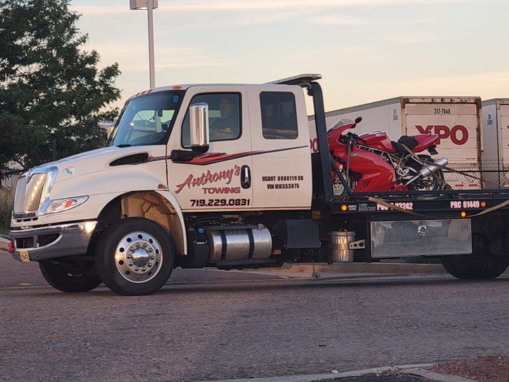
Anthony’s Towing Has Your Back
For riders seeking reliable roadside assistance in and around Colorado Springs , Anthony’s Towing stands ready to serve. Specializing in towing, fuel delivery, wrecker services, and car lockouts, they ensure swift solutions to unexpected road challenges for all drivers.
Trust their seasoned expertise for a prompt and professional response, safeguarding your journey through the picturesque landscapes of Colorado.
Contact them to learn more.
Vehicle Towing
Welcome to Anthony’s Towing, your go-to destination for reliable and professional towing services in Colorado Springs and El Paso County.
Our professionals have worked exceptionally hard to build your trust and earn a stellar reputation. We look forward to working with you and reinforcing our passion for quality work, professionalism, and timeliness. If you have any questions, reach out to us today!
Our Services
Social media, © 2023 anthony’s towing llc. all rights reserved..
Back to top
What’s New on Motorcycle Colorado?
Too much is never enough, so if you’re looking for more good motorcycle stuff on the web, here is a list of some of our favorite sites .
Training=Safety
One other item I hope will be helpful is this list of rider training organizations around the state. Motorcycle fatalities have been increasing in recent years but statistics show that riders who have been trained are far less likely to end up in fatal accidents.
Home | Good to Know | Great Colorado Roads | Motorcycle Camping | Motorcycle-Friendly Motels and Hotels | Rides and Rallies | Motorcycle Dealers and Repairs Colorado Attractions | Motorcycle Rentals and Tours | Colorado Riding Stories | Motorcycle Colorado Blog
© Copyright 2005-2024 by Ken Bingenheimer | Contacts | Privacy | Advertising | Site Design: Bridge

Sales: (303) 539-5010 Service: 303-539-5030 Parts : 303-539-5020
Sales: 303-744-6632 service: 303-539-5030 parts : 303-539-5020, 9700 e. arapahoe rd., greenwood village, co 80112, 10 great colorado motorcycle rides.
Nestled in the heart of the American West, Colorado boasts some of the most breathtaking landscapes in the country. With its majestic mountains, winding roads, and captivating vistas, it’s no wonder that the Centennial State is a dream destination for motorcycle enthusiasts.
Whether you’re looking for a thrilling adventure, a scenic escape, or a combination of both, Colorado’s diverse terrain offers an unparalleled riding experience. In this guide, we’re exploring the 10 best motorcycle rides in Colorado, featuring routes that cater to riders of all skill levels and interests. So, rev up your engines and get ready to embark on an unforgettable journey through the stunning beauty of Colorado’s natural wonders.
1. Mount Evans Scenic & Historic Byway
Your journey on the Mount Evans Scenic and Historic Byway begins in Idaho Springs, a charming, historic mining town. From there, head south on Highway 103 until you reach the intersection with Highway 5, which marks the entrance to Mount Evans Road.
As you ride, you’ll pass through dense pine groves that gradually give way to the tree line, revealing an awe-inspiring landscape of glaciated valleys and jagged rocky peaks stretching out toward the horizon.
Distance: 28 miles (one way) Travel Time: 1 hour
2. Santa Fe Trail Scenic & Historic Byway
This historic route, stretching approximately 184 miles along Highways 350 and 160, takes riders through a diverse range of terrains, from the rolling prairies and vast plains to the foothills of the Rocky Mountains.
The well-maintained roads, gentle curves, and light traffic make it an ideal ride for those seeking a more leisurely yet engaging experience. The Santa Fe Trail Scenic and Historic Byway is undoubtedly one of the best Colorado motorcycle rides for riders who appreciate a perfect blend of history, scenery, and an unhurried pace.
Distance: 184 miles (one way) Travel Time: 4 hours
3. San Juan Skyway Scenic & Historic Byway
The San Juan Skyway Scenic and Historic Byway, a 236-mile loop in Colorado, offers motorcycle enthusiasts a thrilling and visually stunning ride through the heart of the Rocky Mountains. This breathtaking route, also known as the “Road to the Sky,” takes riders on a journey through charming mountain towns, along winding roads, and past the dramatic peaks of the San Juan Mountains.
With its exhilarating twists and turns, as well as awe-inspiring views of cascading waterfalls, crystal-clear lakes, and colorful alpine meadows, the San Juan Skyway provides a sensory feast for riders seeking the ultimate motorcycling experience.
Distance: 236 miles (loop) Travel Time: 6 hours
4. Trail Ridge Road Scenic & Historic Byway
Stretching across the Continental Divide, this impressive highway reaches an elevation of 12,183 feet, providing motorcyclists with a thrilling and challenging ride.
Passing through the twists and turns along Highway 34, you’ll be rewarded with breathtaking views of pristine alpine meadows, rugged snow-capped peaks, and expansive tundra landscapes. The ever-changing weather conditions and limited guardrails at higher elevations add an element of excitement and challenge, making this route a top pick for riders who crave adrenaline-pumping experiences.
Distance: 48 miles (one way) Travel Time: 2-3 hours
5. Unaweep/Tabeguache Scenic & Historic Byway
The Unaweep/Tabeguache Scenic and Historic Byway in Colorado is a hidden gem for motorcycle enthusiasts, offering a spectacular 133-mile ride through diverse landscapes and geological wonders. This remarkable route takes riders on a journey along Highways 141 and 145, showcasing the contrasting beauty of red sandstone cliffs, deep canyons, lush valleys, and the towering peaks of the Uncompahgre Plateau.
Distance: 133 miles (one way) Travel Time: 3 hours
6. Frontier Pathways Scenic & Historic Byway
This 103-mile journey takes riders through picturesque landscapes, diverse terrain, and rich history as they twist and turn along Highway 96 and Highway 165. Starting in Pueblo and passing through Westcliffe and Colorado City, motorcyclists will experience the breathtaking beauty of the Wet Mountains, the Sangre de Cristo Range, and the captivating San Isabel National Forest.
Riders can immerse themselves in the region’s captivating past, with stops at Bishop Castle and historic sites like the Beckwith Ranch, while enjoying the open road and camaraderie of fellow riders on this unforgettable motorcycle adventure.
Distance: 103 miles (one way) Travel Time: 3.5 hours
7. Pawnee Pioneer Trails Scenic & Historic Byway
Pawnee Pioneer Trails Scenic & Historic Byway offers motorcyclists an authentic taste of the American West on its 128-mile route through northeastern Colorado. Riders will experience the serenity and openness of the region’s rural landscapes by traversing vast prairies, rolling grasslands, and the iconic Pawnee Buttes.
This less-traveled byway provides ample opportunities for wildlife sightings and immersing yourself in the rich history of the pioneers who once traversed this land.
Distance: 128 miles (one way) Travel Time: 3 hours
8. Top of the Rockies Scenic & Historic Byway
Motorcycle enthusiasts love Top of the Rockies Scenic & Historic Byway for its thrilling altitude and spectacular mountain vistas. Spanning 82 miles, this high-altitude route ascends over 12,000 feet, providing riders with unmatched views of the Continental Divide, Mt. Elbert, and Mt. Massive.
Adventure-seekers will relish the opportunity to navigate hairpin turns and steep inclines, all while surrounded by the breathtaking beauty of the Colorado Rockies.
Distance: 75 miles (one way) Travel Time: 2 hours
9. Independence Pass
Independence Pass, a thrilling 32-mile route through the heart of the Rocky Mountains, is an exhilarating challenge for motorcyclists seeking an adrenaline-pumping adventure. At an elevation of 12,095 feet, this iconic pass on Highway 82 between Aspen and Twin Lakes offers daring switchbacks and narrow, cliff-hugging roads.
Riders can look forward to breathtaking views of alpine landscapes, cascading waterfalls, and vibrant wildflower meadows during the summer season, making Independence Pass a must-ride destination.
Distance: 80 miles (one way) Travel Time: 2 hours
10. Los Caminos Antiguos Scenic & Historic Byway
This byway is a 129-mile route in southern Colorado, inviting motorcyclists to explore the San Luis Valley’s diverse landscapes and rich cultural history. Winding through charming towns, vast agricultural lands, and sand dunes, riders will experience the area’s unique blend of Spanish, Mexican, and Native American heritage.
Stop by the Great Sand Dunes National Park, marvel at the ancient volcanic formations, and experience the vibrant local culture as you cruise along this storied byway.
Distance: 129 miles (one way) Travel Time: 3 hours
Experience the Best Motorcycle Roads in Colorado with a New or Pre-Owned Bike from Fay Myers
Of course, you’ll need a great bike before you can start exploring the best Colorado motorcycle rides and routes. At Fay Myers Motorcycle World, you’ll find a vast selection of new and pre-owned motorcycles, with options to suit every budget, experience level, and preference.
Our team is made up of motorcycle enthusiasts, experts, and industry professionals, and we share your passion for riding – who better to help you choose a new bike for your next adventure?
Browse our current inventory of new and pre-owned motorcycles for sale in Colorado now, and visit our Greenwood Village motorcycle dealership soon!

- 309-550-7543

Judy Gordon
- September 25, 2020
- Motorcycle Rides
- Colorado , Motorcycle Rides
Best Colorado Motorcycle Rides | 🌄 Guide with Maps, Info, Trips, Roads
Last Updated on: 14th April 2023, 03:45 pm
California may get a lot of attention from motorcyclists, but Colorado also has so much to offer in exchange for a shorter riding season. The state is a popular destination for riders with seven mountain ranges, thousands of mountain peaks, winding roads, and scenic byways galore. Enjoy a 360-degree view of the mountains as you swoop through turns and climb inclines , but just remember to keep a close eye on the weather. With high altitudes comes weather that can be unpredictable! If you’re used to wide-open routes in flat states, you may want to start with one of the shorter Colorado motorcycle routes on the list.
Ready to get started? Here are the must-ride motorcycle rides in Colorado you’ll absolutely love.
Table of Contents
San Juan Mountain Skyway – One of the Best Motorcycle Rides in the U.S.
This magnificent scenic mountain route is frequently named as one of the top 10 motorcycle routes in the country. The 236-mile loop takes you through several mountain passes at over 11,000-foot elevation including a 12-mile section between Ouray and Silverton known as the Million Dollar Highway. Where did this stretch get its name? Some say it’s the million-dollar views, but it actually comes from a 1920 planning meeting in which rebuilding the highway would reportedly cost a million dollars.
The area you’ll explore on this scenic Colorado motorcycle route is called the Switzerland of America with hot springs, majestic peaks, river valleys, and red rock canyons at every turn . Take in stunning views of Mount Eolus, Mount Wilson, and Mount Sneffels and appreciate the Uncompahgre Gorge you’ll pass through on the Million Dollar Highway. You’ll drive along the edge of a cliff against the steep walls of the gorge with no guardrails, so take care on your turns!
Independence Pass – Top Colorado Motorcycle Route to Visit Hot Springs
Enjoy a motorcycle ride that’s decidedly Colorado with a stop at the world-famous Glenwood Springs, the world’s largest improved hot springs. Open from Memorial Day to Labor Day due to road conditions and altitude, this route is 80 miles one-way along Highway 82 from Glenwood Springs to Twin Lakes, Co. It’ll take you about 2 hours to complete with stunning views of aspen trees, mountains, and valleys . You can easily reach Snowmass and Aspen from this route too.
View this post on Instagram A post shared by Visit Glenwood Springs (@visitglenwood) on Oct 30, 2020 at 5:35am PDT
Independence Pass is truly heaven for riders with narrow, twisty roads and just one lane in some sections . This National Scenic Byway takes you up to elevations of over 9,000 feet and past Mount Elbert, the highest summit in North America. There are several ways to take this route. One of the most popular options is starting in Aspen and taking Highway 82 east to the Independence Pass.
Looking for other attractions along Independence Pass? As you ride between Leadville and Aspen, you can stop by the Independence Ghost Town . Located 16 miles east of Aspen, the ghost town was once a large mining town with 1,500 people and 40 businesses. Just nine miles east of Aspen is Grottos Ice Caves with hiking paths to waterfalls, ice caves, and beautiful rock formations.
Trail of the Ancients – Culturally Significant Motorcycle Route in Colorado
If you’re a history buff, you’ll definitely want to ride the Trail of the Ancients , one of the most exciting motorcycle rides in Colorado. This National Scenic Byway is located in Utah and Nevada and circles through the ancient Anasazi Country past cultural and archaeological sites as well as diverse landscapes. Spanning 116 miles, the Trail of the Ancients is the only National Scenic Byway dedicated to archaeology.
View this post on Instagram A post shared by Mesa Verde National Park (@mesaverdenps) on Apr 7, 2020 at 6:30pm PDT
A good place to start is Cortez, Colorado. From there, you can travel to Mesa Verde National Park , the crown jewel of the ancient civilization and one of the world’s top historic monuments. The park was home to the Anasazi for more than 700 years and features over 600 cliff dwellings and 5,000 known archaeological sites. From there, you can continue to the Ute Mountain Tribal Park, the Four Corners Monument, Hovenweep National Monument, then finally the Crow Canyon Archaeological Center.
Mount Evans Scenic and Historic Byway – Highest Motorcycle Route in America
Looking for a scenic but short motorcycle ride in Colorado? Try the Mount Evans Byway along Mount Evans Road. You’ll get bragging rights for riding down the highest paved road in North America at 14,130 feet elevation!
Mount Evans Road starts in the mining town of Idaho Springs and takes you on Highway 103 to the south to the junction of Highway 5. Slowly, pine trees will give way to an exposed mountainside with views of peaks and valleys carved by glaciers. You might even spot bighorn sheep and mountain goats along the side of the road .
The entire route is just 28 miles but takes almost two hours to complete.
One of the top attractions along the route is Echo Lake . In the summer, you can visit Echo Lake Lodge, a 1926 log cabin with a four-sided fireplace and famous trout.
Beaver Meadow National Scenic Byway – Most Exciting Colorado Motorcycle Route

Looking for a Colorado motorcycle route with straightaways combined with winding paths? The Trail Ridge Road scenic byway is a great choice if you’re a bit intimidated by some of the very high-altitude motorcycle rides in Colorado without guardrails. You’ll also enjoy magnificent views of the Rocky Mountains National Park with everything from wildlife and pine forests to rocky mountain peaks. Within minutes, you’ll move from a mild temperature to a cold temperature as the wildlife changes from elk to bighorn sheep while you climb in elevation.
It’ll take about two to three hours to complete this route which is 48 miles one-way. The route leaves from Estes Park and takes you west to Grand Lake, Colorado.
Note that the road is closed during the winter and doesn’t open until late spring. It takes about 42 days on average to plow Trail Ridge Road every year and costs over $30,000 but you’ll see it’s well worth it!
There are a couple of attractions along the route including the small, picturesque Bear Lake and the Forest Canyon Overlook, a popular stop for photos.
Frontier Pathways Scenic Byway – Great Motorcycle Route in Colorado for Prairie & Mountain Views
Looking for a long route that traverses multiple landscapes? The Frontier Pathways Scenic Byway follows a path along the foothills of the Rockies once used by gold prospectors, fur traders, and explorers . Trappers and traders worked along the foothills, Ute Indians lived in the area, and Spanish conquistadors once explored the region. You’ll start in the town of Pueblo about two hours south of Denver then continue on to Westcliffe and Colorado City through the San Isabel National Forest.
View this post on Instagram A post shared by »»»M¡+©h««« (@mista_chell) on Sep 17, 2018 at 7:10am PDT
The ride begins and ends with sweeping views of buttes and prairies with the national forest and mountains in between. Wildlife sightings are very common, especially pronghorn, elk, gray fox, and deer.
Give yourself about three-and-a-half hours to complete this 103-mile iconic Colorado motorcycle route which includes a 16-mile backtrack. The entire route is a 2-lane, pathed highway that’s even RV-accessible and good for beginners.
Looking for attractions along the way? Stop at the Dinosaur Museum at Canon City, spend a few hours at Lake Isabel, and grab a picture of Bishop Castle , a castle completed by one man beginning in the 1960s with a fire-breathing dragon.
Are you excited to hit the open road and try some of the best motorcycle routes in Colorado for yourself? Just remember to check the weather first as many routes are not open during the winter and early spring. If you need to hire a Colorado motorcycle shipping company to start your next adventure,, give us a call at Federal Motorcycle Transport at (877) 655-3492 for a free estimate!
Search by Category
Search For more helpful Resources
Check Out Our Related posts

Top Michigan Motorcycle Events – Swap Meets, Bike Blessings & Motorcycle Rallies in Michigan
Last Updated on: 16th April 2024, 10:42 pm Michigan, known for its stunning landscapes and open roads, is a haven for motorcycle enthusiasts. Each year,

Best Motorcycle Rides in Massachusetts 🌉 | 7 Top MA Motorcycle Roads
Last Updated on: 8th April 2024, 01:44 pm Rev your engines for the Bay State! Nearly 150,000 Massachusetts residents are registered motorcyclists. You can explore

New Mexico Motorcycle Shipping – Federal Motorcycle Transport – NM Motorcycle Transport
Last Updated on: 7th April 2024, 03:27 pm With its desert terrain, rugged mountain ranges, and winding scenic roads, New Mexico is a wonderful state

Florida Motorcycle Laws | 🏍️ Florida Helmet Law, Motorcycle Endorsement, and More
Last Updated on: 29th March 2024, 09:10 am Are you thinking of hitting the open road on your motorcycle in the Sunshine State? Before you
Our Clients' Feedback
Our reviews, federal motorcycle transport.
4.91 stars based on 313 reviews
Member Discounts
200 National St East Peoria, IL 61611
309-550-7543 Monday thru Friday 8:00am to 5:00pm CST Email: [email protected]
We are an agent for

© 2023 Federal Motorcycle Transport | Privacy Policy | Shipping Terms and Conditions
The Ultimate Colorado Motorcycle Tour
Refreshed on June 10, 2022
Dream rides are made in Colorado. Vast plains and high desert give way to soaring peaks among the Rocky Mountains, while western towns scattered here and there evoke the best of the past. Colorado has it all. And we want to ride it all. So we got busy and designed an ambitious 9 day, 2400+ mile rider’s ride that traverses alpine mountains, deserts, plains, and deep canyons. The result – a grand loop through the best of Colorado.
Riding in Colorado
Colorado is one of the most rideable states in the union. One can imagine ancient geo-thermal gods gathering to craft a landscape just for motorcycling. The Southern Rocky Mountains are almost entirely in Colorado. Mount Evans and Pikes Peak rise-up in close proximity to each other, luring riders to ascend their paved roads to over 14,000 feet.

One could say that Colorado has two personalities. To the east, The Great Plains roll into Colorado approaching the foothills of the Rocky Mountains just west of Boulder and Denver. Not many will find pleasure riding this side of the state. But starting at the eastern foothills of The Rockies, extending west to the border with neighboring Utah, a more pleasing personality emerges that is a match for any sport touring enthusiast.
Mountains and forests create both opportunity and obstacles for riders trying to get from one part of the state to another. A glance at the tour route in places may look unnecessarily long. And for anyone on a dual sport, or otherwise happy riding gravel, it may be. Unfortunately, many undeveloped areas are separated by unpaved roads which are not always suited to sport touring bikes. Consequently, the defined route was careful to follow paved roads exclusively.
What to Expect
This tour starts in Grand Junction near the state line with Utah and follows a looping pattern around the western side of Colorado. Riding days are on the long side – it’s a big state – but they always end in a town with ample accommodations and good restaurant choices to enjoy mingling with the locals. Feel free to start the ride at any point on the route or take the ride in either a clockwise or counterclockwise direction.
Temperatures will vary from hot in the lower plains to cool if not downright chilly in the high mountains. And since all of Colorado is at least 1000 feet above sea level, mornings typically start on the cool side even in July and August. Gear-up in layers and plan to peel off one or two as the day goes by. Not everyone may agree, but a heated liner is by far the simplest layer to use – it’s light, easy to pack, and nicely covers any temperature condition. For more on heated gear read The Ins and Outs of Heated Gear .

Daily ride times generally run 5+ hours without considering stops. Plan to start each day as early as possible to get the most from sunlit hours. The scenery on this ride is incredible and packed with picture taking opportunities so naturally stops along the way, not just for food and gas, are a must. After allowing for stops, each day should end by 5 or 5:30pm. That said, this tour puts the emphasis on riding.
Several daily itineraries include destinations that are off the main route. For example, a stop at Mesa Verde National Park on the first day, or rides to the top of Mt Evans and Pikes Peak. These extras are included in the estimated daily ride times and miles; however, if pressed for time they are easy to bypass.

Be aware of road construction on US-50 Construction began in April 2021 and will continue through November 2023
Colorado DOT is working on a 4 mile improvement project between mile posts 123 and 127 in the Little Blue Creek Canyon a few miles west of Sapinero.
Check the Colorado Department of Transportation site before starting your ride. For convenience, consider signing up for text alerts from the Department of Transportation at https://us50info.com . Additional useful links are included in the Resources section at the end of this article. Construction will impact the tour route on Day 2 and Day 4; read more about alternate route options in the daily itineraries that follow.
Lastly and not surprisingly, there are other good roads in Colorado not covered by this tour. An unfortunate but necessary compromise to ensure an optimal touring experience. The planned route strikes a balance between road quality, ride miles, and the desire to end each day in a town with decent hotel and restaurant choices.
Day 1 – Grand Junction to Durango via Mesa Verde National Park
Grand Junction is one of the larger towns in Colorado located less than 5 miles from the border with Utah. The name Grand Junction is taken from the confluence of the Gunnison River and Colorado River around which the town was built. The 60,000 residents who make their home here are involved in farming, growing fruit, and cattle ranching. Tourism is also a big help to the local economy.
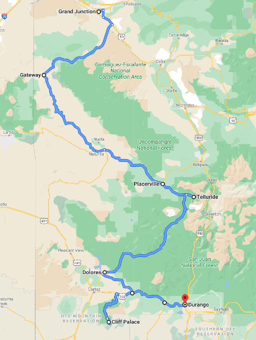
Start day 1 early enough to cover 330 miles and just over 7 hours of riding time that includes stops in Telluride and Mesa Verde National Park before arriving in Durango for the evening. That’s a lot of riding time, mostly a nod to the twisty nature of the roads, in particular the Mesa Verde National Park road.
Leave Grand Junction on US-50 south toward Delta and then connect with CO-141 to Gateway. CO-141 is a quiet two-lane road passing through valleys occupied by cattle ranchers. Monuments along the way call out a few notable landmarks. Past Gateway, where CO-141 crosses the Dolores River, the road takes on a welcome twistiness as it follows the river between canyon walls.

Continue straight through the roundabout on CO-145 just past Placerville toward Telluride about 4 miles up the road. Telluride is one of many well-known ski villages in Colorado. The town has a nice mix of restaurants and coffee shops offering an alpine atmosphere for an early lunch or late coffee.
Leave Telluride returning to the roundabout on CO-145, and this time take the exit toward Rico, continuing on CO-145 all the way to Dolores CO. This is a scenic ride on a well paved 2 lane highway through the San Juan National Forest. Not too twisty, but just right for a relaxing afternoon ride.
The route makes its way between canyon walls along the Dolores River to a small town of the same name, the first example of many western towns to come. Main street has a friendly vibe that fairly reflects the nature of the town’s 1000 residents. Any one of the cafés in Dolores, and pretty much every small town, serves up good food and enough coffee to fuel the day’s ride.
Leaving Dolores, cut over to CO-184 toward Mancos. This is another lightly traveled two-lane road surrounded by ranch land. Mancos marks the junction with US-160 and the need to make a decision about visiting Mesa Verde National Park. A turn to the right, westward on US-160 extends the ride into the park, a left goes directly to Durango.

Mesa Verde National Park is known for ancient cave dwellings that were once a thriving Pueblo village. The park preserves thousands of archeological sites including 600 cave dwellings. The road into the park is long and twisty – itself sufficiently entertaining to justify this side trip. Allow 2 hours riding time from Mancos to Mesa Verde and back (about 60 miles). From Manco, Durango is only another 30 minutes or so away.
Durango is a relatively large town, together with Grand Junction one of the two most populated on the west side of the state. Everything one needs for a comfortable evening is here. Great hotels, shops, galleries, and of course restaurants and pubs scattered along Durango’s historic Main Avenue and throughout town. A few convenient-to-downtown hotel choices can be found along the Animas River on the west side of town between 5 th Street and 11 th Street.
Day 2 – Durango to Alamosa on the Million Dollar Highway
Riding Colorado never gets old, and the ride from Durango to Alamosa is just another example why. Plan a long day and consider leaving time at the end of the day for a side trip to the Great Sand Dunes National Park just east of Alamosa.
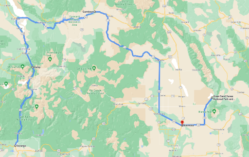
Leave Durango on US-550, also known as The Million Dollar Highway, going north to Ouray. Exactly why it’s called The Million Dollar Highway is up for debate, but the experience riding through canyons formed by the San Juan Mountains is priceless. The town of Ouray itself is a historic district with plenty of well-preserved buildings highlighting its roots as a mining town in the late 1800’s.

Ride out of Ouray on US-550 to Montrose. This section of highway is not quite as twisty, but still scenic. Montrose will feel like riding through urban congestion compared with the first part of the day, but pretty quickly the ride turns onto US-50 heading to Gunnison. Notice the signage pointing to Black Canyon of the Gunnison National Park at the junction with CO-347 – keep riding. We come back to the National Park on Day 4. Today is about making it to Alamosa and an optional side trip to Great Sand Dunes National Park.

Plan ahead for construction related road closures and significant delay on US-50 to Gunnison at mile post 123 near Sapinero as mentioned earlier. To bypass the construction, continue north from Montrose to Delta rather than turning east on US-50. At Delta take CO-92 toward Crawford and on to Sapinero to re-connect with US-50 and then continue to Gunnison.
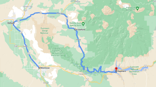
The ride on US-50 is scenic showing the landscapes characteristic of western Colorado. Mostly a two-lane highway with occasional passing lanes and other opportunities to get around summertime RVs. Small towns along the way offer refreshments and fuel while others are so small they may escape notice. Just a great road to lose yourself on.
Gunnison is the only large town on the ride today. With a population a little smaller than Durango, it offers plenty of choices for an early afternoon stop. And it’s the last major town before the day ends in Alamosa.

A few miles past Gunnison, look for the junction with CO-114, it’s not well marked. CO-114 is a simple two-lane highway stretching through western Colorado ranchland with panoramic views of the hillsides; one last sort-of twisty bit before Alamosa. The scenery doesn’t let up either. The Continental Divide is notable 35 miles after turning on CO-114. The pull out also marks the summit of North Cochetopa Pass. This is the first of several times this ride crosses the Continental Divide as it traverses Colorado.
The small town of Saguache marks the turn onto US-285 for a more or less direct path to Alamosa where the riding day ends. But for those who left enough time, consider riding on to Great Sand Dunes National Park. It adds another two hours round trip riding time and 100 miles but worth the time to get a glimpse of this national park known for the tallest dunes in North America (which are surf-able by the way).
Day 3 – Alamosa to Gunnison over Slumgullion Pass
Get ready for a long riding day through the best roads in south central(-ish) Colorado, with a brief dip into New Mexico. Highlights include rolling though the Rio Grande National Forest, again crossing the Continental Divide, and cresting the San Juan Mountains by way of Slumgullion Pass (elevation 11,530 ft).
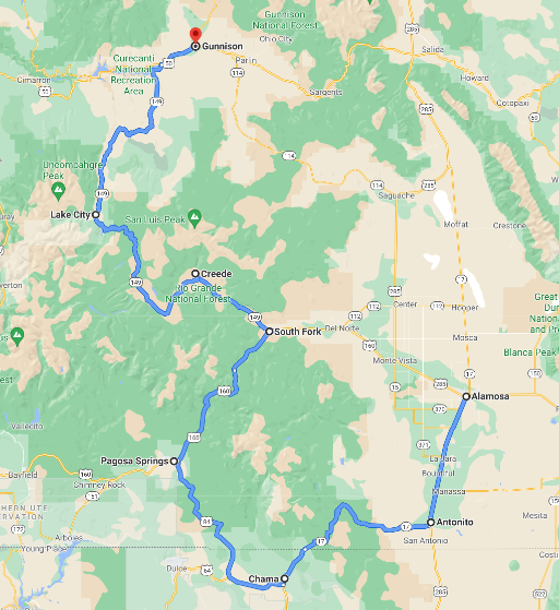
Leave Alamosa on US-285 south to Antonito. Apologies for the next 30 miles of straight road so early in the morning, but a necessary path to connect with CO-17 west into the Rio Grande National Forest. CO-17 is a mountain road featuring good pavement reaching elevations over 10,000 feet with plenty of twisty turns and vista points. Not a technical road, but a good ride.

The small town of Chama New Mexico lies about 7 miles south of the Colorado state line in the Southern Rockies at over 7800 feet. The area is popular year-round for outdoor activities. Just past Chama, take US-64 west and then connect with US-84 toward Pagosa Springs to return to Colorado.
The ride from Chama is filled with miles of ranchland stretching to scenic mesas on both sides which in turn lead to the town of Pagosa Springs tucked in the San Juan National Forest. Pagosa Springs has a busy main street with plenty of shops and cafes perfect for a short break.
Follow US-160 out of town toward South Fork. The Rio Grande National Forest closes in around the well maintained mostly two-lane highway as it winds through cattle pastures. Eventually pastures give way to forests as the road continues into the hills passing the Treasure Falls Observation Site. This is not a technical road, but one that patches together strings of sweepers. Some of the best curves are a few miles past the observation site.

The pull out at Wolf Creek Pass marks the summit at 10,856 feet, and also features a monument marking the point where US-160 crosses the Continental Divide, (the second crossing for those keeping count).
Continue on US-160 as it winds up, down, and through the Rio Grande Forest. At South Fork turn north on CO-149 to Lake City. This stretch of road continues through the Rio Grande National Forest but takes a more twisty path. The landscape is lightly covered by pine trees and native grasses. Catch views of the Rio Grande River running along the road in parts.
The ride from Lake City to Gunnison on CO-149 is a lot more of the same rolling hills and wide sweeping turns. A perfect cool down at the end of the riding day.
Day 4 – Gunnison to Aspen via Black Canyon of the Gunnison National Park
After three road-full days, day 4 may feel a bit light with just over 5 hours of riding. But start early and use the extra time for to enjoy Black Canyon of the Gunnison National Park.
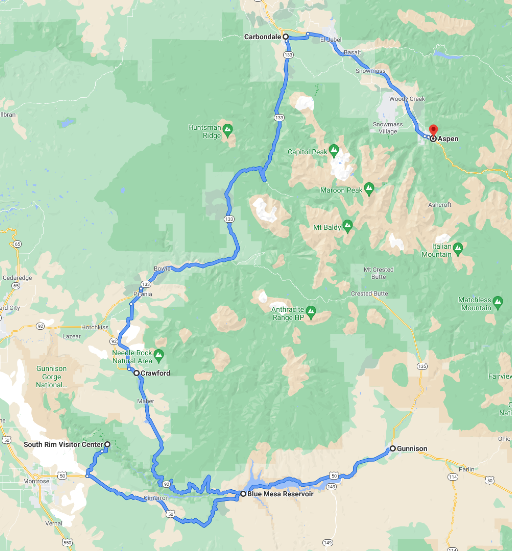
Leave Gunnison on US-50 heading west toward Sapinero. The first 8 miles or so are an unavoidable re-ride up to the junction with CO-149, but all new after that. If a visit to Black Canyon of the Gunnison National Park is of interest, then keep heading west on US-50 toward Cimarron (reminder to plan for road construction on US-50); otherwise turn north toward Crawford on CO-92.
A detour to Black Canyon of the Gunnison National Park adds 80 miles and two hours riding to the day; more if traveling on a day when construction closes the road, as explained in a moment. Follow US-50 past Cimarron to the junction with CO-347. Turn right to follow CO-347 for 7 miles to the South Rim park site. The South Rim is well developed and the most popular area in the park. A visitor center offers information and restrooms, but there are no restaurants here. As an alternative, the North Rim is accessible from CO-92 (avoiding the extended ride on US-50) and may seem like a more efficient way to visit the park. Unfortunately, this less touristed area also calls for riding 7 miles or so of unpaved road. For those who are OK with that, take Black Canyon Road west off CO-92 a few miles south of Crawford directly to the North Rim.
Now having explained how to get to Black Canyon of the Gunnison National Park, on US-50 it’s also necessary to put a fine point out the problem caused by planned road construction. If tour dates coincide with road closures, or even a time when the road is minimally open, then it is preferable to forego the side trip on US-50 to Black Canyon of the Gunnison National Park. The best option, while keeping to the tour route, is to visit the North Rim from Crawford including riding 7 miles of unpaved road. Any other detour requires more time than the riding day allows.
Back on the main route, head northwest on CO-92 from US-50 less than a mile west of the Gunnison River bridge. If the detour around US-50 road construction was necessary on Day 2, then CO-92 will look familiar albeit from the opposite direction. CO-92 is an underappreciated 2 lane highway that climbs into the Gunnison National Forest. The first section follows the Gunnison River along the edge of the Black Canyon of the Gunnison revealing striking views of the valleys and canyons along the way.

The small town of Crawford was known for the café that legendary rocker Joe Cocker opened during the years he lived on the Mad Dog Ranch near Crawford. Joe died in 2014 and was buried in the town cemetery across the street from his Café. Unfortunately, the café is no longer in business.

Continue through Crawford and on to Crawford Road toward Paonia and then get on CO-133 toward Carbondale. The next 60 miles on CO-133 are filled with scenery that characterizes western Colorado. The North Fork of the Gunnison river meanders along the roadside separating the ranchlands on the other side. Eventually canyon walls rise and narrow the view. The roadway itself is punctuated with sweeping turns, plenty of passing areas, and the opportunity to make good time. The road does however offer some interesting bits in the higher elevations of the White River National Forest toward Carbondale.
The entrance to the Redstone Historic district is immediately recognizable by the abandoned bee-hive shaped coke ovens that line the highway. These ovens were used to heat coal into coke, a cleaner burning fuel. They are what is left of early Redstone mining operations.

The highway continues its scenic path to Carbondale, a small town with enough amenities for one more afternoon stop. On the other side of town, take CO-82 east to Aspen. Relax a bit and settle in for 4-lane highway riding. This is popular alpine country featuring two major resorts, first Snowmass and then Aspen, with roadways built to accommodate swarms of winter travelers. Summer activities in the mountains are popular too, so comparatively heavy traffic is likely.
The town of Aspen is literally built around ski runs. The lifts terminate in town while the mountain provides a lush green backdrop for outdoor seating at many of the wide range of restaurants and bars. What a great way to end the day!
Day 5 – Aspen to Colorado Springs via Pikes Peak
The air on a summer morning in Aspen is fresh and crisp. Try one of the many coffee houses scattered around town for breakfast, and then get on the road early to allow time for Pikes Peak in the afternoon.
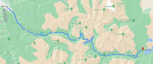
The day starts on CO-82 east through the valley from Aspen Mountain to Twin Lakes. This reasonably twisty two-lane road lined by groves of aspen trees delivers a little bit of everything making for an energizing start to the day. While the first miles are uneventful, the turns get tighter and come one after another as the altitude rises above the tree line to over 12,000 feet at the break between the White River and San Isabel National Forests. In places the road narrows with no shoulder demanding a little extra attention. Pullouts are available here and there to take in views of the surrounding valley and hills. The overlook at Independence Ghost Town is worth a stop. That’s followed by a major pullout, also worth a stop, at Independence Pass which also marks the Continental Divide (the third crossing).
From here there’s no where to go but down, in a good way. And so the ride winds it’s way past remnants of winter snow, around hairpin turns, and past Twin Lakes. At the junction with US-24, turn toward Buena Vista. US-24 follows the Arkansas River. Not a particularly exciting road, albeit scenic in places, US-24 provides an opportunity to relax and maybe make up time.
US-24 becomes US-285 at the small town of Buena Vista. Watch for the junction with US-285 North to Denver. The next 80 miles or so, first on US-285 and then turning onto US-24 at Antero Junction, are best described as easy riding separated by sweeper turns and a backdrop of wide prairies stretching to rolling hills in the distance. Think of it as a way to make highway-speed between Gunnison National Forest and San Isabel National Forest to the east.
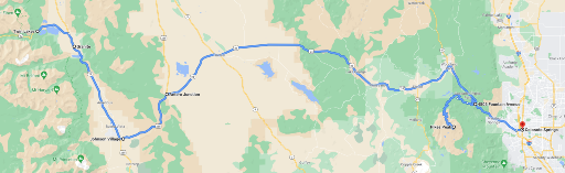
US-24 is largely surrounded by arid ranch land, pastures and rolling hills in the distance. Consider a stop to stretch and gas up in the small town of Hartsel, just past the point where the Middle Fork South Platte River crosses the highway.
Eventually the long stretch of US-24 gives way to the Pike National Forest, the town of Cascade, and then Pikes Peak where upon the road once again develops a personality. At Divide, an honest-to-goodness one stoplight town, the road name changes from US-24 to CO-67. Keep on US-24 through Woodland all the way to Cascade. Watch for the turn onto Pikes Peak Highway North Pole; (probably obvious, but to be sure, North Pole is a Kris Kringle-style tourist attraction at the foot of Pikes Peak).
Pikes Peak Highway is the second highest paved road in North America at 14,115 feet. Only the road to the summit of Mount Evans is higher and by a mere 15 feet at that. Find the highway entrance a half mile off US-24 marked by a simple overhead sign. Allow a good two hours from this point to cover the 20 miles to the summit and return. Pikes Peak is not a National Park and a toll is required to take the highway to the summit. Visit the Pikes Peak pages of the Colorado Springs City website to get the latest information on Pikes Peak road conditions and a current weather forecast. The summit road may be closed periodically while construction wraps up on a new visitor center being built on the summit. The Summit House Visitor Center will feature informative exhibits, a gift store, and dining facilities, when it opens in early summer 2021.
Once past North Pole and after a toll stop, the road twists and turns for miles to the base of Pikes Peak where the real climb begins. The road is well paved but narrow, lined by aspens and pines, and with limited shoulder room in many areas. Mile markers along the way show the elevation. Mile marker 7 indicates the starting point for the famous Pikes Peak International Hillclimb (PPIHC) race which finishes at the summit. The annual race in 2021 is scheduled for June 27 th during which the road will be closed to traffic; check the PPIHC website for details.

The Pikes Peak Mining Company lodge provides one last opportunity for a break before the final leg to the summit. From here the tree line falls away yielding to rocky patches of mountain grass and expansive views to the horizon. The switchbacks are sharp steeply banked affairs and are sure to intimidate less experienced riders.
After a few self-congratulatory selfies at the summit, head back down to Cascade and then take US-24 into Colorado Springs to wrap-up the day. Unlike Woodland and Cascade, Colorado Springs has an abundance of hotel choices and nightlife. But if hotel and restaurant choices aren’t important and the extra 30 minutes to Colorado Springs matter more, then there are a few motels available in Woodland. Either way, Day 6 comes back through Woodland to head north toward Estes Park.
Day 6 – Colorado Springs to Estes Park via Mount Evans
The sixth riding day in Colorado runs through the Pike National Forest and into the San Isabel Forest, on to Mount Evans, and then to Estes Park in the Arapaho National Forest to end the day. Be ready for another long day filled with memorable roads and a ride to the summit of Mount Evans.
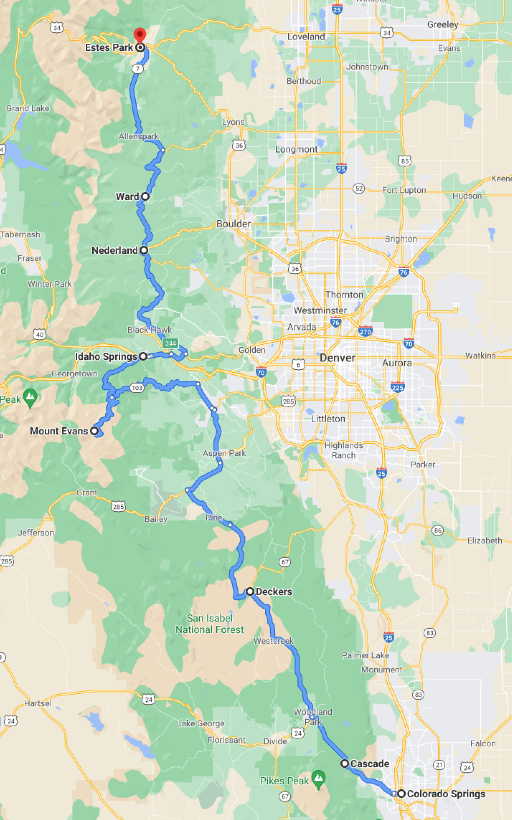
Leave Colorado Springs and head back to Woodland Park where the ride turns onto CO-67 North. CO-67 may feel like a straight road after Pikes Peak, but it’s a perfect start to the day as it rolls and sweeps through forested hills and valleys. An occasional series of 30MPH corners keep it interesting.
At the intersection with US-285 take a right (east) toward Conifer where the route turns onto County Road 73 North. At Evergreen, jump over to CO-74, still going North. Both the County Road and CO-74 are nicely paved and relatively quiet 2 laners with plenty of Colorado ranchland scenery and picturesque towns along the way.
At the intersection with CO-103, turn left to follow this gently curving road west to connect with Mount Evans Road. Echo Lake Lodge sits prominently at the intersection offering the only stop for refreshments in the area. Mount Evans does not have a visitor center or amenities of any kind at the summit. A fee is required by the National Forest Service to enter the Mount Evans Recreation Area, but unlike Pikes Peak a National Park Pass will get you through.

The road to the summit is reasonably well paved with narrow shoulders or none at all in many places. It starts calmly, but gradually dials up the turns to eleven. The same cautions apply here as on Pikes Peak – the climb is steep and the switchbacks near the summit may intimidate inexperienced riders. That said, this is a ride one won’t soon forget. Take a look at the article Mount Evans by Motorcycle for more about what to expect.
Head back down from the summit and re-connect with CO-103 at Echo Lake Lodge. Remember to pick up a souvenir at the lodge before heading toward Idaho Springs. CO-103 continues to throw some pretty aggressive twists for the first 5 miles or so before settling down to a fun country road entering Idaho Springs. Top up the tank and take a break at one of the cafes in town before riding on. Leave town on I-70 east for about 5 miles and then jump on US-6.
Look for the junction with CO-119 North to begin riding the Peak to Peak Highway. This scenic byway runs through the Arapaho and Roosevelt National Forest past Nederland, Ward, and Allenspark before ending in Estes Park. These roads are all well paved and offer a mix of turns sure to end the day with a smile.
The town of Estes Park, known as the gateway to Rocky Mountain National Park has much to offer. Head toward picturesque W. Elkhorn Avenue/E. Elkhorn Avenue between West Drive and Virginia Drive to experience local restaurants, bars, and shops.
Day 7 – Estes Park to Laramie via Rocky Mountain National Park

Estes Park on a summer morning is a special place where chilled mountain air mixes with the aroma of fresh hot coffee at an outdoor café. Throw in anticipation of full day riding in the Rockies and the excitement is hard to contain. Leave Estes Park early to make the most of the day and allow time for stops here and there. The roads ahead are complex and scenic at the same time.
Take US-34 out of Estes Park directly into Rocky Mountain National Park. A fee or America the Beautiful park pass is required to enter. Once inside, simply stay on US-34 through the entire length of the park to enjoy the best views and access to amenities. Consider a stop at the Fall River Visitor Center, not far from the entrance, to pick-up information about current activities. Be aware that gas is not available in the park and cell service is spotty at best.
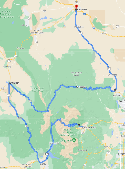
The roads are crowded during the summer months and have few passing zones. Fortunately, there are plenty of pullouts and vista points throughout the park. Riding high into the Rockies, above 12,000 feet, the boulders and alpine grass that surround the road fall away steeply into forested valleys far below. The experience of riding here will inspire the environmentalist in even the most hardcore urbanite. Stop at the Alpine Visitor Center, the highest in the National Park system at 11,796 feet, to discover interesting facts about the high terrain, grab a snack, or simply take a break.
Within a couple miles, US-34 descends once again below the tree line into forest land and continues to the western park entrance and the Kawuneeche Visitor Center just beyond that.
At Granby, take US-40 west past Windy Gap Reservoir. Then turn onto CO-125 north to Walden. The landscape transitions to cattle country and aspen groves. A quiet ride before turning back into the Rockies once again.

Gas up in Walden and then take the junction with CO-14 eastbound toward the Rocky Mountains on the horizon. This part of the ride side-steps Rocky Mountain National Park to the north passing through State Park state park (that’s right, a park named “State Park”). The Moose Visitor Center in Gould has lots of information to share about wildlife in the area.
CO-115 never becomes a complex twisty road, but it will entertain with periodic S-curves, sweepers, flowing rivers, and beautiful forest and canyon views. Services in the area are sparse, so mind the tank.
Eventually the canyons give way to open terrain and CO-14 meets US-287 where the ride turns north. Grasslands and occasional slight turns characterize the next 50 miles on US-287 into Laramie WY where the day comes to an end.
Laramie is a reasonably good size city with over 32,000 residents. The town carries an oversized western reputation mostly due to numerous movies and TV shows set in or about the city. The University of Wyoming is also located here which creates a strong economic base for local hotels and restaurants.
Day 8 – Laramie to Steamboat Springs over Battle Pass
Grab coffee and gas up before riding out of Laramie on WY-130 westbound. Some of the best coffee shops are in the center of town on the south side of the university.
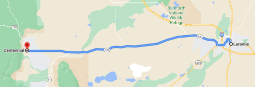
Don’t be discouraged by WY-130’s relative straightness to Centennial WY. After Centennial, WY-130 becomes the Snowy Range Scenic Byway climbing to Snowy Range Pass in the Medicine Bow National Forest. Unlike Colorado, the highway in Wyoming features ponderosa pines in the lower elevations and spruce and fir trees at higher elevations.
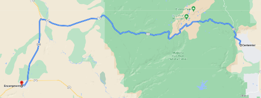
Make a stop at the rustic Libby Flats observation point. From the stone observation platform, one can see Rocky Mountain National Park to the south, and to the west Medicine Bow Peak and the Sierra Madre Mountains.
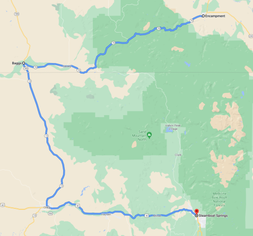
Eventually WY-130 comes to an end at the junction with WY-230 where the ride turns south to Riverside and Encampment. More miles through open prairies. First to Riverside where WY-230 transitions to WY-70, and then through neighboring Encampment and on to even more prairie land after that. But don’t despair, the Battle Pass Scenic Byway section of WY-70 over the Sierra Madre Mountains of Wyoming offers plenty of turns and views of the surrounding Medicine Bow National Forest. The Scenic Byway continues its ascent to Battle Pass and the Continental Divide (for the fourth and final time) at 9,915 feet and then starts a long and twisty descent out of the National Forest.

The remainder of WY-70 into Baggs passes through rolling hills and patches of sage brush. The roadway takes a turn here and there making it a somewhat better ride than many connector roads, (where “connector road” refers to an interlude between true motorcycle roads).
Turn south at Baggs on WY-789 south to Craig Colorado; the road name changes to CO-13 at the state line. Not much to say about this road. It’s a long mostly straight two-lane highway through rolling hills and pastures.
Steamboat Springs is less than an hour away from Craig on US-40 east. The surrounding cattle, wheat, and hay farms provide scenery while the road loosely follows the Yampa River. Hayden Station, a coal-fired power plant that will begin shutting down in 2027, appears on the horizon. Past Hayden, the road begins a pattern of sweeper turns all the way into Steamboat Springs.

Steamboat Springs took its name in the 1800s from a single hot spring, not surprisingly, called Steamboat Spring. That hot spring is still active in the center of town. With a population of over 25,000 residents and a robust outdoor lifestyle, Steamboat Springs offers plenty of hotel and restaurant choices.
The ride into town from the west passes through the old downtown area made up of restaurants, bars, and shops. However, the majority of hotel choices are on the east side of town near Steamboat Ski Resort. Keep the ski village in mind for coffee before leaving town in the morning.
Day 9 – Back to Grand Junction via Grand Mesa National Forest
And finally, the last day of the ultimate Colorado ride. Look forward to more rolling hills surrounded by farmland and pastureland. The day culminates with a ride along the picturesque Grand Mesa Scenic Byway before coming to a close where it started in Grand Junction.
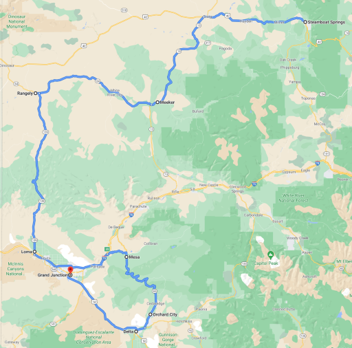
Leave Steamboat Springs westward toward Hayden, re-riding (unavoidably) 40 miles of US-40 back to Craig. On the west side of Craig, turn south on CO-13. Soon the two-lane highway opens to green farmland, views of the Yampa River and then Williams Fork, all wrapped in easy sweeping turns. For Colorado, these lowlands, at a relatively modest 6100 feet, stretch uninterrupted to the horizon on all sides. The morning freshness is intoxicating.
A couple miles past Meeker turn onto CO-64 to continue west. More farms, ranches, and wide sweepers. Eventually the White River appears. The river carves a path along the roadside offering a new visual element to the canonical western landscape.
The town of Rangely marks the point where the ride turns south onto CO-139. Gas and a few restaurant choices are available in town. The ride out of Rangely is uneventful and stays that way for a good number of miles. But then what started slowly, builds into a pretty interesting road. The best parts are about 20 miles from Rangely, in the area of Douglass Pass in the Book Cliffs Mountains. The hills close in forcing the road to weave its way through. Eventually fir trees cover the hills and that familiar feeling of riding a mountain road returns, while see-through s-curves add personality. The climb reaches an elevation over 8,250 feet at Douglass Pass. The pass is recognizable by a cattle grate and radio tower installation located in an unusually large pullout. If not for those landmarks, one would very likely ride right past this scenic overlook. On a clear day the La Sal Mountains in Utah are visible to the southwest.
Coming down from the pass to the south is a steep ride arguably better than the ascent. The scenery is classic mountain vista and the turns are well spaced and in sections allow visibility from one to the next. Adrenaline levels drop-off as CO-139 winds through the surrounding valleys, but no one is likely to get bored with the frequent sweeping turns. And yes, there are some soulless sections of straight desert road to work through. A little bad with the good.
At Loma connect with I-70 eastbound. This short hop on the interstate, along the Colorado River, bypasses Grand Junction and instead exits 20 miles later onto CO-65 South Grand Mesa to ride the Grand Mesa National and Historic Scenic Byway southbound.

Make a quick stop at the informative pullout not far down CO-65 and then enjoy the next 55 miles to Orchard City. The area is filled with recreation sites of all kinds from skiing to fishing all packaged in natural beauty. The aptly named Grand Mesa is the largest flat-top mountain (aka “mesa”) in the world. The road through the National Forest atop this mesa at 10,500 feet offers one more chance to enjoy views from the high mountains of Colorado.
After leaving the National Forest, the roadway straightens out considerably as it makes its way to Cedaredge and then on to Orchard City. From there continue on CO-65 to the junction with CO-92 where the ride turns west to connect with US-50 at Delta. Unwind for the next 50 miles back to Grand Junction where this 9-day rides ends.
Colorado – So Much More Than The Rockies
Riding Colorado yields strikingly different experiences, from traversing the highest peaks in North America to trekking through arid desert to visit cave dwellings. This tour was optimized to bring together the best roads and most remarkable destinations Colorado has to offer while avoiding unpaved roads and minimizing the need to re-ride an area.

No mistaking The Ultimate Colorado Motorcycle Ride is ambitious even for experienced motorcyclist but one that will leave long lasting memories of incredible roads through areas of stunning natural beauty. The numbers tell the story…
- Summitted the #1 and #2 highest paved roads in North America;
- Crossed the Continental Divide in 4 distinct places;
- Rode 8 National Forests;
- Visited 4 National Parks;
- Rode highways and byways in 3 states;
- Covered approximately 2490 planned miles;
- All in 9 amazing days
So where to next? That’s not an easy question to answer with so many good choices within reach of Grand Junction. Start with the national parks in Utah. Arches and Canyonlands are not far across the state line. Then there’s Grand Tetons National Park and Yellowstone National Park up north in Wyoming. The Black Hills, Deadwood, and Sturgis are not too far to the east through Wyoming as well. Looking south past Utah, the Grand Canyon is a must-see, particularly from the less-touristy North Rim. The options go on and on; why stop?

Did we hit the mark?
Click the Thumbs Up or Thumbs Down button to email your feedback. Your questions and comments help improve American Sport Touring. Your email is not used for any other purpose. Please read our Privacy Policy .
Tour Summary
Useful links, you may also like.
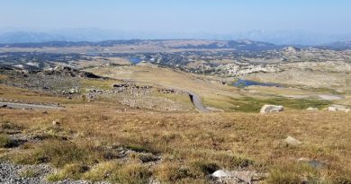
Ride Greater Yellowstone’s Top Motorcycle Roads
This demanding ride from Red Lodge follows Beartooth Highway, Chief Joseph Highway, and National Park roads through Yellowstone to Jackson WY.
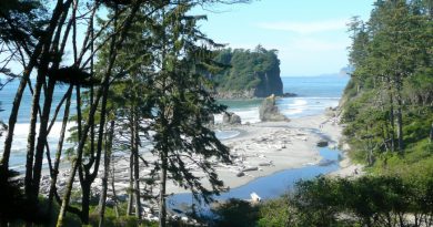
Ride the Olympic Peninsula Loop
A motorcycle ride around this scenic Olympic Peninsula loop in Washington State makes a memorable getaway to forest roads and seaside vistas.
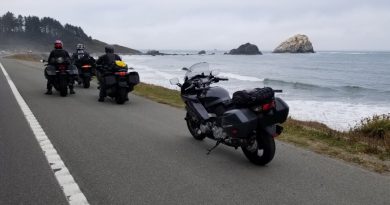
Two Day California Highway 1 Ride
Don’t just dream about riding California Highway 1; see how easy it is to add a fun two day ride on the coast to your next touring adventure.
Cookie Information
Privacy overview.
Colorado’s Best Seasonal Roads for Motorcyclists

The Rocky Mountains are a motorcyclist’s playground. With epic views of the Continental Divide as it zig zags its way across the state, and the never-ending twisty roads that accompany it, it’s a no-brainer why so many two-wheeled enthusiasts love it here.
Some of the best roads Colorado has to offer to motorcyclists are only rideable 6 months out of the year due to the heavy snowfall the state sees in the cooler months. After all, it can snow at high elevations twelve months out of the year!
This summer I made it a point to ride nearly every seasonally closed road the Centennial State has to offer. Here are six of Colorado’s best seasonal roads for motorcyclists, ranked.
6. Cottonwood Pass
Connecting Buena Vista to Almont, Cottonwood Pass offers scenic views of the Continental Divide and cresting at 12,126 feet. 2019 was the first year that Cottonwood Pass was drivable as a fully paved road. In previous years, the western slope of the pass was gravel as it descended towards the Taylor Park Reservoir. The western slope is used as an open range for cattle, so be cautious as you wind your way through the scenic drive. You may just end up in a herd of cows! Cottonwood Pass is typically open May – October.
While this road may come in last place on this list, it is definitely not a bad road. It’s just up against some very beautiful competition.
5. Guanella Pass
Guanella Pass is a summer time go-to ride for most motorcyclists looking for a day ride near the front range. Georgetown, the historic mining town that starts the Northern end of the 22-mile pass, is roughly an hour from Denver, making it an easy ride for those who don’t have days to spare on a sight seeing adventure.
The ride takes about an hour from start to finish. While there’s no shortage of landscape changes and switchbacks, you’ll also want to keep your eyes peeled for wildlife. From moose, bighorn sheep, and the ever adorable yellow bellied marmot, there’s plenty to see besides the surrounding landscape.
Best time to take an adventure over Guanella? Definitely during the peak of the fall foliage, and on a weekday when traffic is significantly lower.
4. Independence Pass
Coming in fourth is Independence Pass. This ride is for the history buffs. Now a part of the Top of the Rockies Scenic Byway, Independence Pass was once a historic stagecoach toll-road in mining country, connecting the then-boomtowns of Leadville and Aspen. The Ghost Town of Independence sits just off the western slope of the pass and offers a glimpse into the state’s mining history.
The road crests at 12,095 Feet Above Sea Level along the Continental Divide in the Sawatch Mountain Range. Vehicles over 35 feet in length are not allowed to cross the pass due to tight, winding road. At times the road becomes narrow and single lane, and at others there are sheer drop-offs with no guardrails. The road typically opens around Memorial Day Weekend every year and closes the first week of November.
>>> Read Next: Independence Pass Motorcycle Guide
3. Kebler Pass
Kebler Pass is home to the world’s largest Aspen Grove, making it one of Colorado’s premiere leaf-peeping destinations in the Fall. Thousands of aspens create a vibrant, yellow-hued forest that line the roadway as it twists through the groves.
From October to May, the road closes to automobiles due to an average of 350 inches of snowfall every winter. In the summers, this well-maintained, 33-mile dirt road twists and turns through thousands of Aspens from McClure Pass to Crested Butte.
>>> Read more about Kebler Pass in my West Elk Loop Blog !
2. Trail Ridge Road – Rocky Mountain National park
The highest continuous paved road in North America takes second place on my best seasonal roads list. The road connects the western side of Rocky Mountain National Park in Grand Lake to the Eastern edge near Estes Park. The 48 mile road will take you from alpine valleys to barren tundra with wildlife sightings throughout. With 11 miles of roadway above 11,500 feet, and a summit 12,183 feet above sea level, the Trail Ridge Road will offer significantly different temperatures and scenery as you ascend and descend through the park.
Trail Ridge is a sight to see as soon as the road opens in May, when the roads are freshly lined with 10 foot snowbanks. In the late Summers when the snow has melted, a barren tundra occupied by Elk, Coyotes, and other wildlife are sure to be a sight. Not to mention the views.
At times, there are no guardrails along Trail Ridge Road. Intermediate riding skills, at minimum, are suggested for this ride.
1. Mount Blue Sky Scenic Byway
Coming in at number one, is the highest paved road in the North America: Mount Evans Road. You may also know it as the Mount Blue Sky Scenic Byway , as the mountain peak was renamed in 2023 . Unlike Trail Ridge Road, Mount Blue Sky is one way up, and one way down. In the summers, the summit will often see high temperatures in the 30s and 40s due to an elevation of 14,265 feet.
>>> Read Next: Mount Blue Sky Scenic Byway Motorcycle Travel Guide !
Mount Blue Sky Scenic Byway is not meant for entry-level riders, as there is no room for error once you make it above treeline and into the tundra section of the road. In fact, this may be the hardest, yet shortest ride on the list, at 15 miles in from the Echo Lake entrance to the summit.
The thrill factor as you make your way around multiple hairpin turns on extremely narrow, poorly maintained roads will also keep you on edge. You’ll be happy you’re on a motorcycle, and not a car or large truck, as you pass other vehicles along the steep cliff faces that offer no guard rail protection. The views from the top of the summit are worth braving the road’s dangers to see at least once.
>>> Looking for more Colorado Motorcycle Travel Guides? Click here!
Save the blog for later, pin it!
You may also enjoy

Little Switzerland, North Carolina: Everything You Need to Know!

How to Pack a Motorcycle Like a Pro

My Favorite Motorcycle Camping Gear of 2023

Grab some gear for your next ride

Leave a Comment Cancel Reply
Sign me up for the newsletter!
Colorado Springs Motorcycle Rides

Colorado Springs lies an hour south of Denver, CO, and the state's second most populous city is an excellent adventure destination just like Denver. Nestled close to the mountains at an elevation of 6,035 ft., Colorado Springs is a great home base for motorcycle trips in the southern portion of the state. Colorado Springs motorcycle rides offer the ability to explore high altitude vistas and deep pine forests a matter of minutes outside of town. Pikes Peak looms nearby and attracts thousands of race enthusiasts and riders each year, but there is plenty to keep riders occupied in the surrounding area as well. Below are some of our favorite motorcycle rides in Colorado Springs and the southern Front Range of Colorado as selected by the REVER team.
The staff at REVER lives to ride, and we're always pushing the limits to explore new areas of Colorado from our Eagle, CO home base. Below we've picked selected some of favorites from the Colorado Springs area. I've lived in Colorado for over 11 years, and these routes around Colorado Springs are some of my favorites because they're less crowded than many Denver areas. But be aware, some of these routes are more challenging than others. We recommend respecting your limits and doing your homework before attempting any ride.
Tips For The Best Motorcycle Rides In Colorado Springs
There is much to see as you head west into the mountains on a Colorado Springs motorcycle ride, and destinations like the Royal Gorge in Canon City, Great Sand Dunes National Park, and more are all within a couple hours drive. You can even cruise right out of the city and into one of the area's best dual sport trail networks in Rampart Range. With so many roads and trails to explore, you need a solid game plan before heading out on motorcycle rides near Colorado Springs. REVER is a great tool to plan and execute the rides you've been dreaming about with ease.
Discovering the best motorcycle rides in Colorado Springs and the surrounding mountains is simple with REVER. Just open the app, gas up and hit the throttle. You can track your ride, share your favorite rides with others, join like-minded communities and more. It's free to sign up, and you can get started immediately. For the best riding experience, REVER Pro members can unlock great additional features to make their rides unforgettable. Get turn by turn directions, discover points of interest and twisty roads, keep your friends and family informed of your location in real time and so much more.
One final note, weather and altitude are a big factor in motorcycle rides near Colorado Springs and shouldn't be overlooked. Be prepared for rapidly changing weather, icy roads in spring and fall, and potential altitude sickness. Rain gear , warm layers and a good supply of water like a hydration system is a must for any ride. Colorado offers some of the best camping in the country, but the choice campsites are miles from civilization, so make sure your motorcycle camp kit is up to snuff before you go. Many routes are closed seasonally, and May to September represents the ideal time to ride most of these roads. After that, many high altitude roads and mountain passes will be closed for the season due to snow and ice. It's wise to check conditions and weather before you set off on any ride in Colorado no matter the time of year.
Colorado Springs Attractions
After a hard day exploring the surrounding area, Colorado Springs has many attractions you won't want to miss. Two geological features highlight the list in The Garden Of The Gods and Pikes Peak . The Garden Of The Gods is worth a quick detour to check out the unique red rock formations in town, but you will want to reserve a good part of the day if you're riding up Pikes Peak or taking the railway. The historic Broadmoor Hotel is worth a visit if you're in the area as well, and you can even have lunch nearby at Restaurant 1858 near Seven Falls. Finally, Colorado Springs features the highest and only mountainside zoo in Cheyenne Mountain Zoo.
Castle Rock Gulch
While many rides around Denver and the Interstate 70 corridor can be busy and crowded during the summer, Colorado Springs offers a bit of a break in its surrounding mountain areas. This two hour ride near Buena Vista, CO and Salida, CO is perfect for a quick escape. Start by taking Route 24 from Colorado Springs through Lake George, CO until you reach County Road 307. Backtrack east until you link up with County Road 187 and then ultimately County Road 185. The last section of the trail becomes County Road 175 or Ute Trail. It will lead you down to Salida on the north side of town to finish the route. There are plenty of offshoots to explore, and much of this trail is in BLM land, so dispersed camping is allowed. Keep an eye out for fire pits or pull offs that denote quality camping spots.
When you're finished with this ride, you can jet over to Nathrop, CO and head west on county road 162 to check out Saint Elmo, CO. This is one of the best preserved ghost towns in the area. The smaller ghost towns of Vicksburg and Winfield are also nearby. Or you can check out the newly established Brown's Canyon National Monument to try some Gold Medal fishing or simply relax by the Arkansas River. When it comes to local restaurants, both Salida and Buena Vista offer plenty of options. In Salida, grab a slice at Moonlight Pizza or Amicas. If you're heading back north to Buena Vista, grab a burger at the House Rock Kitchen or pizza at the Eddyline Brewery and Taproom.
<a href="https://rever.app.link/fOuFCIJZfU" class="btn article-preview__btn w-button">View In App</a>

Cordova Pass
The Cordova Pass route starts a couple hours south of Colorado Springs near La Veta, CO. If you're ready for a memorable detour before this ride starts, continue west on route 160 to visit the tallest sand dunes in North America at the Great Sand Dunes National Park. Late May and early June is a great time to visit the park. In early summer, Medano Creek transforms the snow melt from the nearby Sangre de Cristo mountains into a unique Colorado beach scene. You can also surf down sand tunes for a bit of unconventional but addictive fun. For more information, visit the NPS Great Sand Dunes National Park website.
Now let's return to the Cordova Pass ride. This trail begins off Highway 12 south of La Veta, CO and Cuchara, CO. Turn off the highway and head east on County Road 364 until it turns into 46. Just to the north is West Spanish Peak that towers over the region at 13,626 ft. On the way, you'll ride through Apishapa Arch, which is a tunnel carved through an ancient volcanic rock seam. This tunnel is a great place to stop for a photo opp. Once finished, continue on County Road 46 as East Spanish Peak reveals itself. You'll pass through the tiny town of Gulnare, CO that features a solid lunch spot in the Spanish Peaks Inn dive bar. Finish up this ride by heading north to Aguilar, CO where you can link back up with Interstate 25.
<a href="https://rever.app.link/LU54xDr6fU" class="btn article-preview__btn w-button">View In App</a>

Cochetopa Pass
Cochetopa Pass was once the hunting grounds of the Ute Indians and then the site of an old toll road from Gunnison, CO to Sagauche, CO. The pass is easy to navigate in summer and represents a rich area to explore on your bike. Start this route by taking Highway 114 south from Gunnison until you see the pass road on your right. As you ride the trail, San Luis peak looms to the southwest at 14,022 ft. To the east you'll see Cochetopa Dome at 11,132 ft., which is a main feature of the area. The word Cochetopa means “pass of the buffalo” in Ute, and you can imagine this area teeming with buffalo in the past. Pack your camping gear for this ride as there are plenty of primitive camping spots along the route.
Continue along the other side of the pass until you link back up with Highway 114 near Sagauche. If you stop in town, the Oasis offers a solid lunch spot in an otherwise remote area. Or you can head back to Gunnison for pizza at High Alpine Brewing Company or elk burgers at the Ol Miner Steakhouse. For another short two hour plus ride in the area, head down south to Del Norte for the Cross Creek Loop route.
<a href="https://rever.app.link/VKieeBS2fU" class="btn article-preview__btn w-button">View In App</a>

Cross Creek Loop
Ride a high altitude route with plenty of twists and turns from South Fork, CO to Del Norte, CO in the Cross Creek Loop. Begin just south of South Fork, CO and turn off Route 160 onto Beaver Creek Road. You'll pass by Beaver Creek Reservoir, and if you're into fishing, rainbow, brook, and brown trout are found here as well as Kokanee salmon. Camping is also available at Beaver Creek Campground. Continue along the Beaver Creek Valley until you turn up southeast to follow the main fork of the creek into higher elevation. Eventually Beaver Creek Road meets Forest Service Road 332, and you'll take a left turn south. For a quick scenic detour, you can continue straight up the road to Poage Lake.
After turning onto Forest Road 332, plenty of twists and turns lie ahead. You'll pass by more fishing opportunities both north and south off the road here where Race Creek runs between Crystal Lakes. When you reach a 4-way intersection, take a left onto County Road 14. Ahead you'll ride a stunning ridge between the west and east forks of Pinos Creek. Look off to the west to see Hogback Mesa at an elevation of 12,247 ft. County Road 14 eventually meets up with Del Norte at the south end of town to complete this loop.
There are several quality food options in Del Norte including Three Barrel Brewing Company and Colorado Grille & Tap House. Del Norte's Grand Avenue is also worth a look as the main street in town still showcases traditional buildings from the 1800s and early 1900s. Still hungry for another ride in the San Luis Valley after lunch? Check out Cochetopa Pass by heading north towards Saguache, CO.
<a href="https://rever.app.link/mOReaPtagU" class="btn article-preview__btn w-button">View In App</a>

Dyers Park Loop
Experience almost 4,000 ft. of elevation gain on this easy to traverse gravel road north of Alpine, CO (not to be confused with the Colorado ghost town of the same name). This ride begins along the banks of the Rio Grande River as it runs down through the mountains to Texas and Mexico. The entire Rio Grande headwaters area is an excellent destination for fishing, and Alpine, CO is no different. Start this loop by riding northeast out of Alpine on Highway 15 until you make a slight backtrack left and then north onto County Road 63. Continue along this road until you reach a dramatic climb up a ridge with several steep switchbacks. Once on top, ride the ridge and check out the great views of the area including Pine Cone Knob to the east.
Up next, you'll encounter the loop section of the ride, and stay to the right to continue on the route. As the road curves back around south, it becomes Forest Road 611. The main feature in this area is the interestingly-named Pool Table Mountain. You'll see it off to the northwest, and there are a few rougher jeep trails to explore if you're interested. Stay left at the next fork as you continue south, and after you cross the east fork of Alder Creek, make another left. You'll wind through the forest to link back up with the road you came in on. Turn right to head back down to Alpine.
Alpine doesn't have many services, but South Fork is close by and offers several lunch spots. Ramon's is a solid spot for Mexican, or Two Rivers BBQ is owned and operated by first responders. Test your mettle at Two Rivers by taking the Dementors Challenge. Be warned, you do have to sign a waiver for wings so hot they will “take your soul.” If you survive, head south from South Fork for another route in the area known as the Cross Creek Loop.
<a href="https://rever.app.link/vqb6sCelhU" class="btn article-preview__btn w-button">View In App</a>
Elwood Pass
Ride along the east fork of the San Juan River and check out a majestic waterfall nearby on this scenic drive up Elwood Pass. The route starts north of Pagosa Springs, CO on Route 160. You'll turn east onto County Road 667 to head towards Elwood Pass. The East Fork Campground is nearby the start of this road. Continue up the rocky trail along the San Juan River. The entire riverbed is a good spot for rainbow and brown trout if you're into fishing. There is also dispersed camping along the river. Several streams link up with the east fork here, but the highlight is Silver Creek Falls about 8 miles in from Route 160. The trail up to the falls is steep but short, and it makes for a great photo spot.
Once finished at the falls, continue riding west along the river. The road gets a little rougher as you continue up towards the pass. The last section of this ride takes you to an elevation of 11,676 ft. Here you are treated to a majestic showcase of nearby mountains. Long Trek Mountain and Montezuma Peak are to the south, and you'll see Lookout Mountain and Cropsy Mountain to the east. You can either turn back down to Pagosa Springs or explore Forest Road 380. Right near the pass is Elwood Cabin, which is a primitive cabin maintained by the Forest Service that you can rent with reservations. If you're headed back to Pagosa Springs, grab a burger at Riff Raff Brewing Company or some cajun food at The Lost Cajun. Treasure Falls is also in the area if you want to visit another popular local waterfall.
<a href="https://rever.app.link/y3HpAOMDhU" class="btn article-preview__btn w-button">View In App</a>

Marigold Shelf Road
There is plenty to see and do on this engaging ride west of Colorado Springs that starts near the Royal Gorge and heads north through gold mining country. Begin this ride in Canon City, which is home to the Royal Gorge. We recommend skipping the tourist destination and instead heading north on County Road 9 out of town. This route was once an old stagecoach road that is now affectionately called the Shelf Road. It is narrow in parts but represents a great ride for dual sport enthusiasts. This area is also renown for its great rock climbing opportunities. There are two pay camping areas along the road in the Sand Gulch Campground and Bank Campground.
As you traverse the Shelf Road, you'll pass by Red Canyon Park, which is a good spot to pull over and check out the nearby red rock canyons. Continue north through Marigold, CO, which is the site of an old coach stop and ghost town. Eventually you'll arrive at Cripple Creek, CO. This former gold mining town has evolved into a gambling and tourist destination, but the history of the largest gold strike in Colorado is still felt all around the area. Aside from numerous history museums and casinos, Cripple Creek is a great place to stop for lunch. Take a load off and order a burger or wings at Ralf's Break Room, or you can grab a slice at The Cripple Cow. In late August, Cripple Creek is home to the American Veterans Rally & Festival . When you're finished in Cripple Creek, head north on Highway 67 out of town to start a loop around the Cresson Open Pit Gold Mine.
The Cresson Mine is the richest gold mine in Colorado history, and it is still operating today. There is a visitor center nearby if you're interested in learning more about the open pit mining operation. Continue north on Highway 67 until you take a right on County Road 81. To the east, Pikes Peak looms at 14,110 ft., but the smaller peaks of Sheep Mountain and Cow Mountain are visible close by. Continue south along 81 as you see more of the Cresson Mine to the west. You'll arrive in Goldfield and then Victor, CO next. Victor is the sister city of Cripple Creek, and be sure to stop at the Mining Claim 1899 Saloon to try one of their famous burgers. Finish the loop by heading back into Cripple Creek, or take the Phantom Canyon Road south out of Victor to link back up with Canon City. Phantom Canyon was once the spot of a railroad line for the mines, and there are plenty of quality photo ops along the way. Two tunnels and three elevated bridges make this a worthy detour.
<a href="https://rever.app.link/UmNvCdOIhU" class="btn article-preview__btn w-button">View In App</a>

Goose Creek Road
The Goose Creek Road is accessible either from Colorado Springs via Woodland Park, CO or from Denver via Deckers, CO. Once you arrive in Deckers, head west on Deckers Road and take a left on Wigwam Creek Road towards Cheesman Lake. As you ride south, Goose Creek Road will be on your right, but you can also take a short detour down to see Cheesman Lake and ride over the Cheesman Dam. The dam was once the highest in the world at 211 ft. tall. It was first constructed in 1905 to provide water for the growing Front Range area by famous water engineer Walter Cheesman.
Now let's get back to Goose Creek Road. Continue south along the route and to the site of one of Colorado's largest forest fires, the Hayman fire. This area is still recovering, which makes for unique, sometimes eerie scenery. Next, you'll pass by the interesting rock formation known as Sheeprock. This climbing destination is worth a stop for photos. The terrain makes for an engaging ride in this area as you'll encounter winding switchbacks down into wooded draws. Soon after Sheeprock, you'll pass over Goose Creek, which is also the site of the Goose Creek Campground. Goose Creek Road actually becomes Matukat Road as you cross into Park County. The final section of this road is a thrilling ride you won't want to miss. You'll thread between massive granite peaks and down into the valley to link up with Highway 77.
You can turn this ride into a loop by heading south on 77 and then east on Route 24 at Lake George, CO. Once you reach Woodland Park, CO, take Rampart Range Road back to Deckers. This road cuts through a dual sport and ATV paradise with plenty of side roads and trails to explore. No ride in this area is complete without a visit to the famous Bucksnort Saloon. From Deckers, head north on Highway 126 through Buffalo Creek, CO to Pine, CO. Turn right at Pine, and then take Elk Creek Road north until you encounter the Bucksnort hidden in the valley.
<a href="https://rever.app.link/4KIaXHq6iU" class="btn article-preview__btn w-button">View In App</a>

Greenhorn Mountain
Explore the Pueblo, CO area and ride to the top of Greenhorn Mountain in this route south of Colorado Springs. This ride starts in Fairview, CO just north of the oddity known as Bishop Castle. The castle has been hand-built stone by stone by local resident Jim Bishop, and it features three stories that reach to a height of 160 feet. For the Greenhorn Mountain ride, begin at Ophir Creek road, also known as Forest Road 360, which is near Ophir Creek Campground. When you reach a 4-way intersection, turn left onto Forest Road 369 to reach the Greenhorn Mountain wilderness. As you ride, enjoy the remote area and keep an eye out for dispersed camping. You'll encounter two crystal blue lakes as you ride towards the summit. The main road ends just below the peak of Greenhorn Mountain at 12,347 ft.
<a href="https://rever.app.link/tobVqAF6iU" class="btn article-preview__btn w-button">View In App</a>

Hancock & Tomichi To Monarch
Challenge yourself on a rocky and narrow dual sport trail with this scenic ride over the Continental Divide. This route begins west of Nathrop, CO and Salida, CO near two ghost towns. Alpine and St. Elmo were both mining towns from the mid 1800s. A few residents still live here, and they have fixed up the abandoned buildings back to their former 1800s style. St. Elmo is especially worth pulling over for a photo opp. South of St. Elmo, take County Road 295 to begin this ride. You'll follow Chalk Creek, which features several quality fishing spots. As you ride towards the Continental Divide, you'll pass by more historical sites including the Hancock ghost town and the site of the Alpine Tunnel. At one point, the Alpine Tunnel provided railroad service between Denver and Gunnison. Although no longer in service, it remains the highest railroad tunnel in the world. Today the tunnel is sealed for safety reasons, although it is still a popular hiking spot in the area.
Once you've crossed the Continental Divide, gear up for another mountain pass as you ride through a high alpine valley to Tomichi Pass. Below the pass is another ghost town, White Pine, and it has been mostly deserted since the 1900s due to a history of frequent avalanches. Snowblind Campground is nearby and named for the snowy area. Take a left at the fork in the road on County Road 888, and then soon after take another left onto County Road 237. You'll be treated to an engaging road with many switchbacks down until you pass by the Monarch Ski Area. Link up with Highway 50 to end this route. Head back east on Highway 50 to Salida, CO to grab a bite at Currents downtown along the river.
<a href="https://rever.app.link/NgaRjlvmjU" class="btn article-preview__btn w-button">View In App</a>

Hayden Pass
Tackle a moderately-difficult pass through the Sangre de Cristo Mountains in this short one hour point to point ride. Access Hayden Pass by heading south west from Colorado Springs to Canon City and then Cotopaxi, CO. You can either start at Coaldale, CO and take Hayden Pass heading west, or start at Villa Grove, CO and head east on the pass. This is a rocky and sometimes difficult to traverse trail. The west to east route from Villa Grove is the more challenging of the two. Hayden Pass is officially marked as County Road 6 on the map. The area south of Villa Grove is home to the Orient Mine and Valley View Hot Springs. In the summer months, you can view the local migratory colony of 250,000 bats leave the Orient Mine each night to feed on insects.
Once you're done riding the pass, Salida and Canon City offer great lunch spots on the east side. The Whitewater Bar & Grill in Canon City is definitely worth a stop to check out their epic patio. In addition to a solid menu, the patio offers axe throwing, cornhole, fire pits and sand volleyball. If you decide to ride Hayden Pass east to west, you can easily link up with another nearby ride in the Cochetopa Pass route that takes about an hour and a half to complete.
<a href="https://rever.app.link/yFDMx2bnjU" class="btn article-preview__btn w-button">View In App</a>

"You don't stop riding when you get old, you get old when you stop riding." ― Anonymous
- REVER Brigade
Labs & Partners
- Partner With Us
- Press Releases
- Privacy Policy / Terms & Conditions
- Work With Us
- [email protected]
Sign up to our newsletter
© REVER 2024 All rights reserved.
We use cookies to help make Rever better. By visiting this site, you agree to our cookie policy .
50% Labor Day "Flash Sale"
- Motorcycle Roads in United States
Best Colorado Motorcycle Ride East of I-25

Motorcycle Route Author

Rider Reviews

Written Directions
Drive enjoyment, tourism opportunities.

Photo Gallery of Best Colorado Motorcycle Ride East of I-25 (7 Photos)
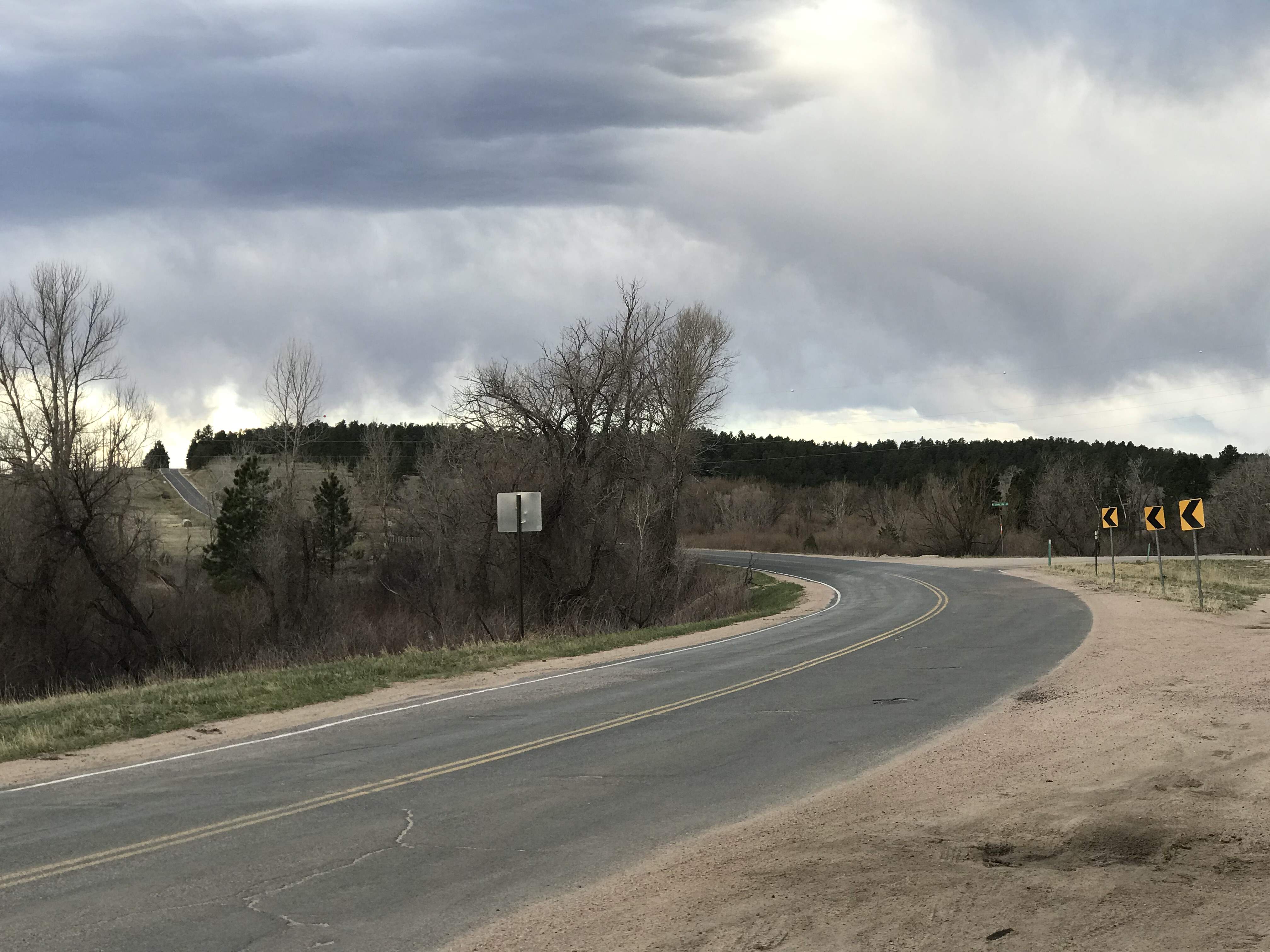
Interactive Views Along This Route
Latitude 38.9858333
Longitude -104.7671778
Latitude 38.9983328
Longitude -104.7055997
Latitude 39.0424443
Longitude -104.5852178
Latitude 39.3456987
Longitude -104.5807825
Latitude 39.5392238
Longitude -104.61385
Latitude 39.4062769
Longitude -104.6511868
Latitude 39.3670542
Longitude -104.6068076
Latitude 39.3903015
Longitude -104.7490484
Latitude 39.327009
Longitude -104.6953295
Latitude 38.9879981
Longitude -104.7692441
Most helpful review of this route
Featured video.
Newest Motorcycle Roads & Rides
 | Routes Around the World")
Best Motorcycle Roads & Rides
 | United States")
Popular Motorcycle Places

Popular Motorcycle Clubs

Signup For eNewsletter
Updates on new roads, events, motorcycle news and more!
Earn McR Points
Help keep motorcycleroads.com free by:, accumulate mcr profile-points to increase your rider status.
- Use our sharing links on the page to notify other riding friends about great roads, events, clubs, & places & earn 1-profile point per share!
- Add likes, star-ratings, comments about a route, event, club, or place & earn 2-profile point per activity!
- Add a route to your wish-list or route’s I’ve ridden list and earn 2-profile points per add!
- Add a photo or video to a route, event, club, or place and earn 3-profile points
- Add a new route, event, club or place and earn profile 5-points! (must be reviewed, approved, & posted)
What to look for

Modal Header

- Coaching Team
- About RawHyde California
- Level 1 - Intro to Adventure
- Level 2 - Intro Plus
- Level 3 - The Next Step
- Level 4 - Expedition CV
- Base Camp Alpha
- Extra Training Options
- Registration - California
- About RawHyde Colorado
- Level 2 - Intro Plusp
- Colorado Backcountry Discovery Expedition
- High Rockies Adventure (2 day ride)
- Rocky Mountain Adventure (5 day ride)
- Registration - Colorado
- Ladies Only Intro Class
- Pre-Training Programs
- Private Training
- Natural Wonders - California to Colorado
- Road to Riches - Colorado to California
- Continental Divide Ride
- Colorado Backcountry Expedition
- Mojave Magic Adventure
- Utah Backcountry Discovery
- Rocky Mountain ADV
- Mid-Winter Adventure
- Spain, Portugal and Morocco Tour
- Big Bikes in Baja
- Baja Essentials
- Patagonia 2024
- Dakar Rally Adventure
- The Best of Argentina, Bolivia and Chile
- Registration - Tours
- Adventure Days
- Get On Adv Fest!
- Weekend at Zakar
- The RawHyde Leadership Institute
- Adventure Days for Motorcyclists
- Adventure Days Overlanders
- Vendor Sign-Up
- Registration - Events
- Expedition65 DVD
- Motorcycles & Equipment
- Gift Certificate
- Fitness & Nutrition
- Words from the Wise
- Request Packing List
Give the gift of ADVENTURE this holiday season!
A RawHyde training course or tour will be the highlight of that special someone’s Christmas.-->