
Mellish Anchorage. Photo Jack and Jude Binder.

Cruising guide to the Coral Sea
On 30 September 1969, the Coral Sea Island Bill officially acquired Australia’s tenth external territory. The Coral Sea occupies that part of the Pacific Ocean off the east coast of Australia between the parallels of Sandy Cape and Torres Strait, bounded by New Caledonia, Louisiade Archipelago, and Papua New Guinea.
Why the Coral Sea?
Superb diving in clear water without jellyfish, great fishing, heaps of wildlife, and plenty of solitude. Also provides a fast, unobstructed passage to Cape York.
Communications:
INTERNET is NOT available once mainland Australia is left behind. Sat phones / Yellowbrick trackers can send messages, and Marine Band frequencies have good reception. Therefore facilities such as Sail Mail should perform satisfactory. VHF signals DO NOT reach mainland repeaters.
In winter, from April to about November, the weather will be predominately South East Trade Winds that are often reinforced during the months of June, July, and August when they can reach 25 to 30 knots. Tasman Sea swell may invade the southern reefs during southern storms.
The summer months of December through to April are the most prone to cyclonic activity, but are also the calmest time. Jack and Jude have sailed the Coral Sea in December and February, finding the weather reports adequate warning to seek shelter if not too far offshore. Bureau of Meteorology (BOM) on HF
The Australia Bureau of Meteorology does NOT directly broadcast Coral Sea weather on HF, but it can be deduced from two sources. The first being Queensland Coastal forecasts broadcast by VMC from east Australia. The second being the Mean Sea Level Pressure weather fax maps broadcast by VMC. A weather fax or decoder connected to a HF is required.
Coastal waters weather forecasts are repeated every four hours and contain up-to-date forecasts, warnings, and coastal observations. In addition, on the hour EST, VMC broadcasts COASTAL and HIGH SEAS WARNINGS. Queensland Coastal Weather Frequencies and Times: Station Day Time (kHz) 7 am to 6 pm Night Time (kHz) 6 pm to 7 am VMC 4426, 8176, 12365, 16546 2201, 6507, 8176, 12365
Schedule: 0330, 0730, 1130, 1530, 1930, 2330 EST
A DVD of our last journey through the Coral Sea showing the five most interesting anchorages is available from our website. http://JackandJude.com/DVD/
The fine print:
Mariners are advised to be prudent and not to trust this information without proper diligence. Although every effort has been made to check the accuracy of the details, the editors and authors do not imply or accept any responsibility for the accuracy of the contents.
CATO ISLAND
A small oval-shaped island lying approximately 230 nm east of Gladstone and about 145 nm east-southeast of the southern end of the Great Barrier Reef. The island lies on the western end of an oval-shaped reef enclosing a lagoon with two narrow boat passages on the northern side. Passage into lagoon by keelboats is doubtful. The lagoon contains numerous coral heads. The sea breaks over the reef in most weather. The reef lies on Cato Bank, which falls away steeply on all sides.
The island is a mound of coral debris 6 m high covered in grass and creepers up to 1 m high. An automatic weather station, with two radio masts and a silver-painted hut, stands on the northeast end of the island. The island is almost entirely surrounded by shore reef. Map available on our website.
1/ Best small boat passage, east end of island opposite weather shed, marked by stake midway. Anchorage, 23°14.671’ S – 155°32.538’ E Protected from E through S winds in 15 m sand patches amongst coral.
2/ Second small boat passage into lagoon, further east by less than 1/2 nm Anchorage, 23°14.600’ S – 155°32.874’ E Protected from ESE through S winds in 18 m sand patches amongst coral.
3/ Alternative anchorage, large sand patch at west end of island Anchorage, 23°14.799’ S – 155°32.086’ E Protected from ESE through S winds in 18 m sand patches amongst coral.
4/ A reasonable anchorage against East Winds Anchorage, 23°14.888’ S – 155°31.929’ E Protected from ENE through S winds in 12 m sand patches amongst coral. Off lying dangers:
Hutchison Rock, 23°15′S 155°36′E, with a depth of 5.5 m, lays 2 nm east of Cato Reef.
WRECK REEFS, including PORPOISE REEF
Wreck Reefs are a narrow, 18 nm long chain of coral reefs and low-lying sand cays in the southern part of the Coral Sea. They lie approximately 230 nm east of Gladstone and approximately 180 nm NNE of Fraser Island.
They rise from a depth of over 3,000 m in the Cato Trough. The reef chain includes a number of small sand cays and three islets: Bird Islet, Porpoise Cay, and West Islet. All three islets support nesting sea turtles and both Porpoise Cay and Bird Islet support nesting sea birds. Map available on our website.
Porpoise Cay, 275 m long, 90 m wide and 3 m high, vegetated with low grass and a succulent similar to Pig’s Face without pink flowers.White Masked Boobies court in winter and nest on its sandy fringe while brown Common Noddies nest within the foliage. We also sighted about 20 pairs of Brown Boobies on the windward edge half tide rock.
Pieces of black coal lay amongst mankind’s plastic in the flotsam line. Embedded in the half tide rock are bits of rusting metal. The coal and metal very likely from the wrecks. Its surrounding lagoon and outer reef host beautiful diving and large pelagic fish including jobfish, tuna, and trevally along the reef edge. Cannonballs retrieved from the wreck can be seen at the low tide.
Bird Islet, approximately 500 m by 250 m wide and 6 m high, has low vegetation and a large colony of nesting seabirds including frigates, noddies, terns, and boobies. The islet sits in a lagoon with a surrounding outer reef. The coral reef to the north of Bird Islet is a sheltered coral garden which is a superb dive location.
West Islet is bare coral rubble and sand only 1.8 m high.
Entrance, 22°11.187’ S – 155°20.877’ E
Anchorage, 22°11.279’ S – 155°20.926’ E Obstructions within anchorage: ROCK WEST, 22°11.263’ S – 155°20.856’ E ROCK EAST, 22°11.239’ S – 155°20.964’ E
Protected from ESE to SW in 12 m sand.
Alternative anchorage in NE weather:
Anchorage 22°11.925’ S – 155°19.639’ E
Find a sand patch amongst the coral in 16 m, some swell.
Kenn Reef 65 nm north of Porpoise Cay is located over 270 nm from the Australian mainland and is shaped like a leg and boot, 8 nm long and 4 nm along its southern edge. Kenn Reef is part of a submerged continental block called the Kenn Plateau, a region characterised by a series of troughs 1000 m to over 3000 m deep.
The three southerly reefs (the boot & ankle) lie upon a common shelf from which the northern reef (the leg) is separated by a deep channel. The smallest and most westerly of this chain (the toe), contains a conspicuous 1.8m high boulder on its NE side, which from a distance appears as part of a wreck. The wreck of a long liner lies on the S side of the reef.
The leg encompasses two lagoons further north with entrances facing SW that are exposed to winter swell. A small sand islet sits on northern one.
Of all the reefs, the southeastern is the largest with three emergent sand cays in its SW part. The only permanent land, Observatory Cay, about l00 m by 50 m and 2 m high has no vegetation. There is excellent anchorage for all winds except northerlies with easy access to these cays from an extensive shallow patch over the purest white sand. But getting to this anchorage requires careful visual navigation to avoid large numbers of coral heads and then passing over a shallow sand spit.
Map available on our website.
Southeastern Reef:
Anchorage, 21°15 066’ S – 155°46.327’ E
Anchorage good from NE through S to NW in 6 m sand inside coral lagoon with close access to Observation Cay with two other transient islets within a mile. Superb diving and fishing. Prolific bird life mainly Common Noddies, a number of Brown Boobies. We saw one Frigate Bird. Two admiralty type anchors exposed at low water near cay on eastern fringing reef may be from the Bona Vista, wrecked there on 18 March 1828. The outer edge is strewn with wrecks. Crystal clear water.
Anchorage outside lagoon, 21°14.963’ S – 155°45.824’ E
Good from NNE through E to SSW in about 8 m sand with submerged coral, opposite possible boat channel to cay.
Channel into anchorage:
Minimum of 3 m over sand bar after depths of 6 to 10 m through isolated coral heads. Easy transit with good light.
1/ 21°14.283’ S 155°45.985’ E about 7 m deep w/ coral heads both sides. 2/ 21°14.419’ S 155°46.165’ E about 6 m deep over submerged coral. 3/ 21°14.693’ S 155°46.244’ E from here turn towards North Cay 4/ 21°14.794’ S 155°46.251’ E pass close to coral head of less than 1 m depth 5/ 21°14.968’ S 155°46.326’ E shallowest, sand bar w/ min 3 m 6/ 21°15 066’ S 155°46.327’ E anchor anywhere in wide sandy basin.
Sand Cay Southwestern Extreme:
Anchorage from SE trades off north side. Several wrecks on shore.
DIAMOND ISLET
East Diamond Islet has a spectacular anchorage with considerable vegetation upon which several species of seabirds nest. A light structure rises out the cay and the air is alive with many species of seabirds, featuring the most Frigatebirds we’ve ever seen. A 2006 report put the numbers at 2,500 Lesser Frigatebirds, a thousand pairs of Red-footed Boobies and very large numbers of Black and Common Noddies, Masked and Brown Boobies, Black-Naped Terns, Sooty Terns, Wedge-tailed Shearwaters, several Red-tailed Tropicbirds and a few Great Frigatebirds.
Anchorage, 17°26.411’ S – 151°04.220’ E
Good protection from NE to SW in 7 m large sand patch with submerged coral heads nearby. Obvious boat channel to cay.
MELLISH REEF
This is definitely one of the Coral Sea’s highlights. One of the larger reefs with a large sand islet enclosed within a lagoon that is the most distant from all land, 580 nm east from Cairns. Therefore wildlife is prolific. The anchorage is good for NW to N to SW winds, although winter swell from the Tasman can create a roll, especially at high tide. Beware! Boobies will land in your rigging.
Anchorage 13062017: 17°24.233’ S – 155°51.903’ E
Protection from NW to SW in 6 m coral sand, with minimum swinging room to a reef ahead. Close to a boat passage marked by an above water rock.
Anchorage 13062311: 17°23.909’ S – 155°51.927’ E
We shifted 1/3 nm north to the other side of a reef awash in an attempt to lessen the southerly swell. Protection from NW to SW in 6 m coral sand, with ample swinging room to reefs ahead and two submerged coral heads astern. An obvious boat passage dead ahead.
Anchorage, 17°25.050’ S – 155°51.620’ E
If necessary, there is an anchorage with better protection from the SW in 8 m over sand.
NOTE : There is a coral head at 17°24.213’ S – 155°51.534’ E shown on some charts, but not others.
Passages through the Great Barrier Reef:
There are many routes to enter or exit the Coral Sea. Too many to describe them all here.
From the South, if departing from Bundaberg, Mooloolaba, or Lady Musgrave, a direct course can be taken under the Swain Reefs. If departing or heading for Cairns, we use Grafton Passage. It is wide, easy, and in the past we have had a favourable wind. When returning to Cairns we plan to arrive at Euston Reef Light around dawn in order to make Cairns in daylight. Safe in strong winds.
Pandora Entrance
In 2013 we wanted to sail as far north as we could in the Coral Sea before heading for Cape York and choose Pandora Entrance as it has deep water until in the lee of the Great Barrier Reef. This proved wise as we were experiencing 30 to 40 knots SE winds. Raine Island Entrance, on the other hand, has a submerged coral barrier exposed to ocean swell.
We rounded Moulter Reef at less than 1/2 nm, with a sand cay, an easily found landmark at its northern tip, sighting breakers a mile or two northwest. We took overnight anchorage 5 nm from Moulter Cay, behind an unnamed reef in a 12 m sand patch close to the reef exposed to 30 knot SE, several other reefs helping to block ocean swell. Next morning, we made a fast passage through the reefs, with one narrow gap between obstacles of 1.3 nm, to another unnamed reef close to the inshore shipping channel. Here we found excellent anchoring behind a low sand cay in 6 m sand and coral rubble. The water was turbid. From there we sailed direct for Mount Adolphus Island.
TRACK -Pandora Entrance to shipping channel:
1/ 11°27.273’ S 144°07.235’ E about 2 nm off Moulter Reef elbow. 2/ 11°23.565’ S 144°01.832’ E about 1/2 nm off Moulter Reef north tip. 3/ 11°26.137’ S 143°58.996’ E midway between obstructions.
Anchorage behind unnamed reef: 11°27.800’ S – 143°57.849’ E
Protection from NNE to S in 12 m sand patch, with minimum swinging room to a reef ahead.
4/ 11°21.447’ S 143°48.087’ E to pass N of Maclennan Cay. 5/ 11°16.643’ S 143°40.648’ E a clear run. 6/ 11°10.509’ S 143°24.692’ E midway of 1.3 nm safe passage 7/ 11°03.005’ S 143°06.767’ E close aboard unnamed reef.
Give the submerged reef off the NW tip a wide berth or it will surprise you.
Anchorage behind unnamed reef: 11°03.242’ S – 143°04.108’ E
Protection from E to SE in 6 m sand and coral rubble. Shipping Channel in sight.
Our FREE web based Coral Sea Cruising Guide, available here , covers these reefs and islets within Australian territory:
Cato Island Holmes Reef Porpoise Reef* Lihou Reef Kenn Reefs* Diamond Islets* Saumarez Reef Willis Islets* Frederick Reef Mellish Reef*
* denotes special destinations
Our E-book format Coral Sea Cruising Guide, available here in multiple formats for A4 printing/PC/Ipods/Ipads/Kindle, also contains historical notes, wreck information, and additional photos of the anchorages and attractions. You can support our efforts by a making a small contribution – Buy us a wine

ALSO ON MYSAILING

Sail Port Stephens Day 3 wrap

2024 World Match Racing Tour season kicks off in Long Beach

Sail Port Stephens Day 2 wrap

Alinghi Red Bull Racing’s BoatOne

The GLOBE40 bound for Valparaiso

GSC – David Linger nearing A Coruña and more!

OGR – Maiden does it again

OGR – 2 more finishers

Sail Port Stephens Passage Series Day 1 wrap

Antigua Classic Yacht Regatta starts next week

Luna Rosa launches with style

OGR – L’Esprit d’équipe 2nd
Join Our Newsletter
- Name First Last
- Comments This field is for validation purposes and should be left unchanged.

Read all of the latest sailing news

Dinghy and Yacht Racing News

News from the offshore world

Cruising Stories from around the world

Boats & Gear
The latest boats and yachting gear

Watch everything sailing and boating
Latest Sailing News, Racing, Cruising, Boats, Gear and more
- Australian Marine Parks

Coral reefscape scenery in the Coral Sea off Cairns.
- Introduction
- Marine debris
- Sea cucumbers
- Management Plan
Welcome to the Coral Sea Marine Park, one of Australia’s most spectacular marine treasures.
The park covers 989,836 square kilometres, lies off the coast of Queensland beyond the Great Barrier Reef, and is one of the world’s largest marine parks.
The Coral Sea Marine Park (CSMP) has a diverse array of habitats, such as coral reefs, sandy cays, deep sea plains and canyons.
Far beyond the Great Barrier Reef, this marine park protects:
- 16 different seafloor environments (including seamounts, canyons and plains)
- 34 vast reef areas and 67 cays and islets
- 15,000 km² of shallow reef systems
- an abundance of marine life.
Here you can find unspoiled world-class dive sites, such as isolated reefs, where colourful coral walls are the perfect backdrop for cruising reef sharks.
The park includes iconic black marlin spawning aggregations near Osprey Reef, and every year humpback whales migrate through the marine park from Antarctica.
You might catch a glimpse of a delicately patterned pipefish, or spot a huge, boldly blotched potato cod. Either way, the excellent visibility will help. You can expect to see for up to 60 metres.
Above the water, marine turtles and seabirds breed in safety on isolated cays. Six of the world’s seven species of marine turtles can be found in the Coral Sea.
This marine park is enormous (2200 km at its longest and 1300 km at its widest).
The Coral Sea Marine Park is managed using National Park, Habitat Protection and Special Purpose zones.
Parks Australia in collaboration with universities, state government agencies and federal partners is conducting research to inform monitoring and ongoing management of the Coral Sea Marine Park.
Publications
Reef health .
- Coral Sea Marine Park Coral Reef Health Survey 2023
- Coral Sea Marine Park Coral Reef Health survey 2022
- Our Marine Parks Grants Round 2: Diving into the Deep 2022
- Coral Sea Marine Park Coral Reef Health survey – 2021
- Coral Reef Health in the Coral Sea Marine Park – 2018-2020
- Differential bleaching susceptibility among coral taxa and colony sizes, relative to bleaching severity across Australia’s Great Barrier Reef and Coral Sea Marine Parks, 2023
- Tempestichthys bettyae, a new genus and species of ocean sleeper from the central Coral Sea, 2022
- Changes in the incidence of coral injuries during mass bleaching across Australia’s Coral Sea Marine Park
Island Health
- Coral Sea Marine Park Island Watch Summary Report Feb-March 2022
- Coral Sea Marine Park environmental assessment of islands, islets and cays of the southern and central reef systems, 2022
- Our Marine Parks Grants Round 3: Coral Sea Marine Park Marine Debris Clean-up Voyage 2022, Tangaroa Blue Foundation
- Coral Sea Turtle Survey 2022-23
- Environmental assessment of islets and cays of Tregrosse and Lihou Reefs, Coral Sea Marine Park, July 2021
- Vegetation Assessment and Mapping of South Islet (Willis Islets), Coral Sea Marine Park
- Environmental Assessment of the Coringa Islets and Herald Cays in the Coral Sea Marine Park - 2019
Click on the map below to see what you can do in the Coral Sea Marine Park.
Download map
For those who make the journey, this marine park rewards visitors with exceptional diving, boating, snorkelling, nature watching and fishing.
Most people visiting the marine park travel on live-aboard tour boats from Port Douglas, Cairns, Townsville, Mackay, Airlie Beach or Gladstone, often calling in at some Great Barrier Reef sites on the way.
The Be Pest Free in the Coral Sea biosecurity information sheet provides information to people visiting the Coral Sea Marine Park about the importance of stopping pests such as ants and rodents from being introduced onto islands. If you visit the remote islands in the Coral Sea Marine Park you need to consider your impact and ways to protect the seabirds, turtles and plants that make up these amazing but vulnerable island ecosystems.
For divers, some of the most prized underwater sites are in the Coral Sea Marine Park. Explore the reefs of the Coral Sea , including Holmes Reef and Bougainville Reef, each with unique features and a rich variety of species to enjoy.
The wild and remote Osprey Reef has been listed as one of the top ten dive sites in the world.
Some of the locals you may encounter include:
- whales and dolphins
- giant hunters like marlin, swordfish, tuna and sharks
You might even spot a humpback whale between June and November.
There are at least 45 historic shipwrecks in the Coral Sea Marine Park. Click here to find out more about the military and maritime history in the Coral Sea.
Fishing in the pristine waters of the Coral Sea is a once-in-a-lifetime experience. You could expect to encounter:
- marlin, both black and blue
- dogtooth tuna
- giant trevally
- many other species.
Most charter fishing trips will take you on three day or more live-aboard voyages to experience some amazing fishing on isolated reef systems.
The park also supports commercial fishing and shipping, which contribute to economic growth, employment and social wellbeing in Queensland coastal towns and communities.
Recreational fishing is allowed in much of the Coral Sea Marine Park, but not in the National Park zones. Check which zone you’re in before you start to fish.
Explore more of the Coral Sea:
- The Coral Sea - an overview
- Under the Coral Sea
Coral Sea Marine Park, Coral Sea Natural Park New Caledonia, and Great Barrier Reef Marine Park
The Coral Sea Marine Park is an ecologically significant place and an amazing destination.
Problems such as marine pollution, illegal fishing, climate change and invasive species can impact marine environments around the world, including remote ones like the Coral Sea.
Parks Australia is looking after the Coral Sea Marine Park by working in partnership with:
- communities
- other government departments
- New Caledonia.
New Caledonia
Our intention to work collaboratively with New Caledonia was formalised in 2010, through a joint declaration that sets out our desire to work together on science, management and regional capacity building activities.
The progress of activities under the Declaration is periodically published in a newsletter. They are available in both English and French:
- 2020 newsletter - English / French
- 2019 newsletter - English / French
This work is helping us learn more about the Coral Sea Marine Park, and find the best ways to protect it now and into the future.
Map of marine parks in the Coral Sea
Coral Sea Marine Park, Coral Sea Natural Park New Caledonia, and Great Barrier Reef Marine Park (PDF)
In 2016, Parks Australia organised the Coral Sea Clean-up and Bio-discovery Voyage.
Marine park managers were joined by:
- marine debris scientists from the Commonwealth Scientific and Industrial Research Organisation (CSIRO)
- volunteers from Tangaroa Blue, Surfrider Foundation, and Take 3 community organisations.
The voyage team travelled across the marine park, collecting data on locations and levels of marine debris, including microplastics.
Understanding what types of debris are out there and where they turn up helps us work towards eliminating them at their source.
And of course, the team removed all the marine debris they found during the voyage.
Back in port, the team worked with artists in Cairns to host a marine debris art project.
Artists sculpted marine animals from debris, and the exhibition helped raise community awareness of marine debris issues.
Some local tour operators are now undertaking voluntary marine debris clean-ups as part of their visits to the Coral Sea.
Marine debris (rubbish in the oceans) is a global problem.
Debris includes:
- discarded and lost fishing nets and buoys
- millions of plastic bags
- water bottles
- countless tiny bits of plastic (microplastics).
Some rubbish is dumped directly into the oceans. Other pieces are lost at sea. A lot starts on land, travelling to the oceans in drains and waterways, or on the wind.
Marine debris kills marine life through entanglement and ingestion:
- Turtles and birds get tangled in discarded nets and drown.
- Seabirds eat plastic, thinking it is food, and their chicks starve when fed regurgitated plastic instead of fish.
Microplastics and their compounds make their way up the food chain, including into the seafood we eat.
And marine debris spoils the places we like to visit, making beaches unsightly.
Sea cucumbers are animals, not plants.
They have tube feet and are related to sea stars and sea urchins (they’re echinoderms).
Sea cucumbers play an important ecological role, acting like seafloor vacuum cleaners. They suck up dirty sand, digest the attached particles (this is their food), and then excrete clean sand back out onto the seafloor.
In tropical areas sea cucumbers are known as bêche de mer or trepang.
For some they’re a prized seafood delicacy, sometimes taken illegally and traded on the black market.
Parks Australia works closely with Maritime Border Command and the Australian Fisheries Management Authority to stop illegal activity in marine parks.
In recent years we’ve been collaborating with these organisations to stop foreign fishing crews trying to smuggle sea cucumbers from the Coral Sea.
When these illegal operators are caught, their boats are destroyed, their catch seized and their captains and crews prosecuted.
We’re also working with scientists to find out how sea cucumber populations respond after poaching.
A crucial part of managing our parks is to have a good understanding of what’s in them, and to make checks for unexpected changes such as:
- the arrival of pest species that might impact local ecosystems
- the start of a coral bleaching event.
As part of the 2016 voyage, the team worked with scientists to survey the plant and animals living on islets and surrounding reefs in the Coral Sea Marine Park.
This was part of Parks Australia’s Bush Blitz program .
The teams surveyed four sites and found 178 different types of plants and animals.
At least 100 species were documented for the first time in the park, improving our understanding of species distributions here.
And two bug species new to science were discovered.
No pest species were detected, which was great news for the park.
The results of this survey provides a benchmark, so when we revisit these sites and repeat the surveys, we’ll have a picture of how these environments are changing.
A management plan for the Coral Sea Marine Park came into operation on 1 July 2018.
- Maps of the marine park, including the zoning
- Australian Marine Parks Guideline - For the authorisation of commercial tourism and general use activities on islands in the Coral Sea, Ashmore Reef and Cartier Island Marine Parks
Regional engagement
The implementation of the Coral Sea Marine Park Management Plan is supported by the Coral Sea Marine Park Advisory Committee .
989,836 km²
Depth range
0 to 6,000 m
Average depth
Download detailed map.
Coral Sea Marine Park map
Allowed activities
View the activity table
Talk to us about Coral Sea Marine Park

Stay in touch
Subscribe to receive important updates about your marine parks. Enter your email address and click "join now".
- Australian Government
- Marine parks
- Coral Sea Marine Park
- Indian Ocean Territories
- North marine parks
- North-west marine parks
- South-east marine parks
- South-west marine parks
- Temperate East marine parks
- Access & use
- Apply for a permit
- Commercial approvals
- Other approvals
- List of authorisations issued
- AMP Alert Service
- Park management
- Management plans
- Management programs
- Partnerships
- Resources and publications
- South-west maps
- Indian Ocean Territories maps
- North-west maps
- Coral Sea maps
- Temperate East maps
- South-east maps
- Marine science
- Australian Marine Parks Science Atlas
- Science under the surface
- Science partnerships
- Marine parks in the Indian Ocean Territories
- Ocean Discovery and Restoration
- Science knowledge and needs
- Fisheries assistance and user engagement
- Kakadu National Park
- Norfolk Island
- Christmas Island
- Pulu Keeling
- Australian National Botanic Gardens
© 2013–2024 Parks Australia (Commonwealth of Australia)
We acknowledge the Traditional Owners of country throughout Australia and recognise their continuing connection to land, waters and Culture. We pay our respects to their Elders past, present and emerging.
PLUS DE RESULTATS
Destinations
Inspirations.
- Curiosities
- Get inspired
Top 5 things to do in the Coral Sea

The Coral Sea, from Australia to Vanuatu
The Coral Sea lies to the west of the Pacific Ocean, off the north-east coast of Australia, between Papua New Guinea and New Caledonia, Vanuatu and the Solomon Islands. It is dotted with islands, some of which are uninhabited, and is home to the Great Barrier Reef marine belt: the largest ecosystem of coral reefs in the world, decorated with amazing underwater landscapes.
Spend a night in the ‘ white sandy paradise’ of Whitsunday
The Whitsunday Islands lie off the coast of Queensland, Australia , about 50 kilometres from the small seaside town of Airlie Beach. Close to the Great Barrier Reef, these 74 islands feature crystal-clear waters, secluded beaches and hidden bays. The white sapphire of the archipelago is Whitsunday Island with its idyllic Whitehaven Beach . This long strip of silica sand bordered by a tropical forest is indisputably one of the most beautiful beaches in the world . It might be a bit cliché, but Hill Inlet is well worth a visit. From there, you can admire the 7 kilometres of Whitehaven Beach that stretch forth from its lookouts, joining an estuary whose shades of blue and green change with the tides. Prolong this waking dream by camping overnight. Obtain a permit from Whitsunday Islands National Park and wait for the day’s visitors to return to their boats, leaving you alone, or almost alone, on this little slice of paradise lost. An exceptional experience!

Fly over the heart of the Great Barrier Reef at Hardy Reef
Visible from space, the Great Barrier Reef stretches for over 2,300 km over an area of nearly 350,000 km 2 off the north-east coast of Australia, making it the largest coral reef system in the world. This extraordinary habitat is home to some 400 species of coral, 1,500 species of fish, 4,000 species of molluscs and 240 species of birds. This priceless natural wonder has been a UNESCO World Heritage Site since 1981. Come and claim a front-row seat for this unique and unforgettable experience on the Reefworld pontoon , moored on the edge of Hardy Reef in perfectly preserved shallow waters. It is the perfect place to view this exceptional ecosystem . Choose to explore it by snorkelling, scuba diving or in a semi-submersible submarine. The platform also has an underwater viewing chamber. And a handful of Reefsleepers can even spend a night under the stars on the pontoon . Alternatively, you can enjoy a bird’s eye view during a panoramic helicopter flight over the famous Heart Reef .

Swim in the natural pool at Oro Bay on the Île des Pins
Welcome to the Île des Pins . Almost on the Tropic of Capricorn, to the south of Grande Terre of New Caledonia, the Île des Pins owes its name to Admiral James Cook, who marvelled at the abundance of the majestic New Caledonia pines when he explored the island for the first time in 1774. Now it’s your turn to uncover its treasures aboard an outrigger canoe in Upi Bay . Once inland, you can climb the Pic N’Ga or travel to the Cave of Queen Hortense , which is pierced with tree roots seeking water. Or walk along the trail beside a discreet sandy river to reach the legendary natural pool in Oro Bay, where thousands of multicoloured fish frolic in the dazzlingly clear waters of this lagoon carved from coral. A paradisiacal experience! You can also take a small plane to the Île des Pins from Nouméa , flying over the breathtaking landscapes of the Great South Lagoon , one of six lagoons named as UNESCO World Heritage Sites.

Admire Solomonic art on the island of Santa Ana
Santa Ana , also known as Owaraha, is a small coral island in the Solomon Islands , in Melanesia, east of the island of San Cristobal (also known as Makira). Populated by fishermen and horticulturalists, welcoming Santa Ana is known principally for its sculptural woodwork: understated and elegant ceremonial bowls, paddles, slender clubs and figureheads for war canoes made of black wood, delicately decorated with white patterns and polished shell, pyrite, mother-of-pearl, clamshell, tortoiseshell and more. These objects represent relationships between people, the living and the dead, and other supernatural entities. It is a traditional art that reflects valuable know-how, as does the music, singing and dancing that punctuate the daily life of this Melanesian community during ritual ceremonies, special occasions or simply as a way to welcome visitors.

Listen to the rivers sing in Vanuatu
Head north from New Caledonia to visit Vanuatu , made up of around 83 beautiful islands. Espiritu Santo , or Santo to those who know it best, is the largest island in the group and probably one of the most beautiful. Featuring volcanic hills, fine sandy beaches, lagoons with turquoise waters and its famous blue holes, it is impossible to resist the natural beauty of its landscapes . The west of the island remains very wild, bristling with jagged mountains, while the east and south offer vast plains suitable for farming and dotted with small, isolated villages. Enjoy the opportunity to meet the people who live a quiet and reserved life here, but who are always very welcoming. Take advantage of your time in Santo to enjoy a captivating experience: Women’s Water Music . The women of Vanuatu make rivers sing by stirring, hitting and stroking the water with their hands and arms! A unique art that is passed down from mother to daughter…

Idyllic islands with preserved natural landscapes, carefully protected coral reefs, lagoons with turquoise waters, welcoming locals, and more: discover these distant lands and their natural splendours on a trip to the Coral Sea . Meet the inhabitants , who are the heirs to a range of authentic traditions.
Photos credits : ©iStock
-push")
PONANT takes you there
Sail to the most beautiful islands in the Pacific Ocean
To discover

PONANT's brochures
Would you like to know more about our exceptional destinations?

- Share full article

The Great Wonders Beyond the Great Reef
A recent expedition to the inky depths of the Coral Sea revealed an unknown world of creatures and geologic features.
A dumbo octopus, captured on camera by a remotely operated vehicle in the Coral Sea off Australia’s east coast. Video by Schmidt Ocean Institute Credit...
Supported by
By William J. Broad
- June 26, 2020
What lies off Australia’s Great Barrier Reef , in the Coral Sea? The region was mostly unexplored and uncharted until a recent expedition searched its dark waters, uncovering an abundance of life, weird geologic features and spectacular deep corals. The deepest forays reached down more than a mile.
The expedition was organized by the Schmidt Ocean Institute, founded by Eric Schmidt , the former chairman of Google, and his wife, Wendy. Its centerpiece was a ship, nearly the length of a football field, that could map the remote seabed with beams of sound and deploy tethered and autonomous robots to capture close-up images of the inky depths.
“It blew our minds,” Robin Beaman of James Cook University, the expedition’s chief scientist, said in an interview. “We’ve gone from literally knowing nothing to knowing a lot.”
An earlier leg of the expedition found a gelatinous creature whose length was estimated at 150 feet — potentially the world’s longest example of oceanic life.
The Coral Sea lies northeast of Australia, adjacent to the Great Barrier Reef, and includes a vast protected zone known as the Coral Sea Marine Park . The investigation of its depths ran from late April to mid-June. In an apparent global first, the expedition was conducted remotely because of the coronavirus pandemic. A team of eight Australian scientists worked from their homes and linked up wirelessly with the Schmidt institute’s research vessel Falkor . The setup let them direct, in concert with the ship’s crew, the mapping, as well as the streaming of live video from a tethered robot, opening the dark abyss to human eyes.

Dr. Beaman said the arrangement drove him a little bit crazy because he was stretched between doing household chores and savoring the undersea wonders.
“I’d be washing dishes and want to go back,” he recalled. “I’d call to my family and say, ‘Hey, look at this, look at this beautiful imagery.’ There’d be a nautilus bobbing up and down or a deep-sea squid flying across the screen.”
The region’s thriving population of chambered nautili was a big surprise, Dr. Beaman said. The creature is a living fossil whose ancestors go back a half-billion years — to the early days of complex life on the planet, when the seas were warm. The logarithmic spiral of the animal’s pearly shell echoes the curved arms of distant galaxies, and its beauty has turned the nautilus into a prized commodity, with some of its populations decimated by hunting and trapping. Marine biologists have debated whether the creature should be listed as an endangered species.
“They were everywhere, bobbling around,” Dr. Beaman said of the nautili. “They’re really beautiful animals to look at.” The expedition, he added, had explored a protected zone hundreds of miles off Australia’s coast. The remoteness from civilization helped safeguard the area’s inhabitants and probably explained why the nautilus population was booming.

In all, the expedition mapped more than 13,000 square miles of seabed — an area bigger than Massachusetts — and transformed unknown waters into carefully evaluated realms of Australia’s marine wilderness. Most coastal nations have no research vessels, and thus little ability to explore the sunless depths of their own backyards.
Dr. Beaman said that another surprise was the raw complexity of the deep seabed around the region’s 30 large coral atolls and banks. The expedition found submarine canyons, dune fields, submerged reefs and massive landslides.
“We had no idea what these steep flanks looked like,” he said. “We were astounded. There’s lots of evidence of undersea landslides, some probably millions of years old. You could see that, as the reefs have grown, big, big parts of them have collapsed.”
The team also found the deepest living hard corals in eastern Australian waters and identified as many as 10 new species of fish, snails and sponges.
In the interview, Dr. Beaman noted that the process of discovery from the expedition had only begun; widening circles of scientists and students were now starting to examine the new seabed maps and the days’ worth of video recordings from the robot’s abyssal dives.
“The imagery will be worked on for years,” he said. “It was an amazing experience.”
Like the Science Times page on Facebook. | Sign up for the Science Times newsletter. ]
William J. Broad is a science journalist and senior writer. He joined The Times in 1983, and has shared two Pulitzer Prizes with his colleagues, as well as an Emmy Award and a DuPont Award. More about William J. Broad
Advertisement
Coral Sea Islands

- 1 Understand
- 2.1 By plane
- 2.2 By boat
- 3 Get around
- 4 See and do
- 7 Stay safe
The Coral Sea Islands is a federal territory off the northeast coast of Australia , just east of the Great Barrier Reef . They were separated from Queensland in 1969.
Understand [ edit ]

Scattered over some 1 million square kilometers of ocean, the Coral Sea Islands were declared a territory of Australia in 1969. They are uninhabited except for a small meteorological staff on Willis Island. Automated weather stations, beacons, and a lighthouse occupy many other islands and reefs. These tropical sand and coral reefs and islands are an important nesting area for birds and turtles.
The Coral Sea was the location of the Battle of the Coral Sea in the Second World War .
Get in [ edit ]
By plane [ edit ].
There are no airports in the Coral Sea Islands.
By boat [ edit ]
There are no harbours in the Coral Sea Islands however you may be able to dock somewhere.
Get around [ edit ]
Your only way to get around is by walking or by your own private boat.
See and do [ edit ]
Buy [ edit ].
As the Coral Sea Islands is an Australian external territory, the Australian dollar is the official currency, but there is no economic activity in the Coral Sea Islands.
Sleep [ edit ]
There are no public accommodations in the Coral Sea Islands you will have to either leave or set up a tent.
Stay safe [ edit ]
Go next [ edit ].
- The Great Barrier Reef has much more to offer than these islands
- Has custom banner
- Quickbar with missing information
- See listing with no coordinates
- Has map markers
- Usable parks
- Usable articles
- Park articles
- All destination articles
- Has Geo parameter
Navigation menu
Sustainable Seas: A Diver's Guide to Coral Reef Conservation Travel Experiences

Joanne Hyatt
Table of contents, the plight of our coral reefs: understanding the urgency.
Green Fins: The Code of Conduct for Responsible Diving
Diver's green fins conservation checklist, embark on eco-friendly dive safaris, eco dive safaris.

Sustainable Dive Gear: The Conscious Diver's Toolkit
Dive into sustainability: eco-friendly gear for coral conservationists.

Sustainable Seas Quiz
Engaging with local communities.
Sustainable Dive Practices
Dive with a conscience: your sustainable operator checklist, innovative conservation efforts worth supporting, coral guardians.

"The health of our oceans is not a spectator sport—it's something we all must dive into." - Joanne Hyatt
Dive into Sustainability: Eco-Conscious Gear for Coral Guardians

To conclude your journey towards becoming an ambassador for our oceans' well-being, remember that every action counts—whether it’s picking up litter during beach walks or advocating for marine protected areas. Your passion for diving can be a powerful force for change when aligned with conscious choices both above and below the surface.
Recommended Products

Post a comment
Popular articles.

Riding the Rails Sustainably: A Guide to Eco-Friendly Train Travel Across Continents

Sail Into Sustainability: How to Choose and Enjoy Low-Impact Cruising Options

The Eco-Warrior's Guide to Sustainable Travel Photography: Capturing Memories Without Impact
Never miss a post, share this article, recent post, reconnecting with nature: top eco-friendly yoga retreats for mindful travelers, best self guided bike tours in east asia: an eco-friendly way to explore, more articles.

Login to Tourist Eco
Moscow Metro – Part 2
Have you been to Moscow ? In all seriousness, they have the prettiest metro stations I have ever seen and I still can’t believe how immaculate and lovely every station was. There are several different stations pictured below and this is the second of several posts where I will show you the beauty of the Moscow Metro. Did you see part 1 ? There really isn’t much to say because I think the pictures speak for themselves. I have so many more pictures to share with you!

Have you ever been to Moscow? Is it someplace you have thought about visiting?

She speaks fluent English, French and Spanish, and works for a major airline. And guess what? She’s also a licensed elementary teacher and has an MBA.
Similar Posts

How To Keep The Vacation Feeling At Home
Do you have experiences when you are traveling that you would love to have when you return home? I…

Cars Of Havana
I thought you might like to see some of the shots I took of cars around Havana. No edits,…

Have You Heard Of Worcester, England?
This is an older post but one you probably haven’t seen. I’m taking a break while I’m recuperating from…

Aria Hotel In Las Vegas, Nevada
If you ever travel to Las Vegas, there are plenty of hotel choices and I’m very glad I chose…

5 Ways I Afford To Travel
These 5 things aren’t earth shattering discoveries, they are simple things I do in my everyday life in order…

Visiting The Taj Mahal with Nomadness Style
Have you ever seen a huge group of beautiful Black travelers from different countries wearing traditional dress at…
This is the train STATION?? Oh my god… So gorgeous. Moscow has never even crossed my mind as a possible travel destination but this is gorgeous…Hmmm… LOL
I know, right? We spent several hours in the metro, just marveling at the beauty of each one. Thanks for stopping by!
Leave a Reply Cancel reply
Your email address will not be published. Required fields are marked *
- Articles >
The Moscow Metro Museum of Art: 10 Must-See Stations
There are few times one can claim having been on the subway all afternoon and loving it, but the Moscow Metro provides just that opportunity. While many cities boast famous public transport systems—New York’s subway, London’s underground, San Salvador’s chicken buses—few warrant hours of exploration. Moscow is different: Take one ride on the Metro, and you’ll find out that this network of railways can be so much more than point A to B drudgery.
The Metro began operating in 1935 with just thirteen stations, covering less than seven miles, but it has since grown into the world’s third busiest transit system ( Tokyo is first ), spanning about 200 miles and offering over 180 stops along the way. The construction of the Metro began under Joseph Stalin’s command, and being one of the USSR’s most ambitious building projects, the iron-fisted leader instructed designers to create a place full of svet (radiance) and svetloe budushchee (a radiant future), a palace for the people and a tribute to the Mother nation.
Consequently, the Metro is among the most memorable attractions in Moscow. The stations provide a unique collection of public art, comparable to anything the city’s galleries have to offer and providing a sense of the Soviet era, which is absent from the State National History Museum. Even better, touring the Metro delivers palpable, experiential moments, which many of us don’t get standing in front of painting or a case of coins.
Though tours are available , discovering the Moscow Metro on your own provides a much more comprehensive, truer experience, something much less sterile than following a guide. What better place is there to see the “real” Moscow than on mass transit: A few hours will expose you to characters and caricatures you’ll be hard-pressed to find dining near the Bolshoi Theater. You become part of the attraction, hear it in the screech of the train, feel it as hurried commuters brush by: The Metro sucks you beneath the city and churns you into the mix.
With the recommendations of our born-and-bred Muscovite students, my wife Emma and I have just taken a self-guided tour of what some locals consider the top ten stations of the Moscow Metro. What most satisfied me about our Metro tour was the sense of adventure . I loved following our route on the maps of the wagon walls as we circled the city, plotting out the course to the subsequent stops; having the weird sensation of being underground for nearly four hours; and discovering the next cavern of treasures, playing Indiana Jones for the afternoon, piecing together fragments of Russia’s mysterious history. It’s the ultimate interactive museum.
Top Ten Stations (In order of appearance)
Kievskaya station.
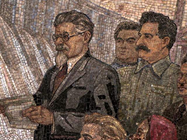
Kievskaya Station went public in March of 1937, the rails between it and Park Kultury Station being the first to cross the Moscow River. Kievskaya is full of mosaics depicting aristocratic scenes of Russian life, with great cameo appearances by Lenin, Trotsky, and Stalin. Each work has a Cyrillic title/explanation etched in the marble beneath it; however, if your Russian is rusty, you can just appreciate seeing familiar revolutionary dates like 1905 ( the Russian Revolution ) and 1917 ( the October Revolution ).
Mayakovskaya Station
Mayakovskaya Station ranks in my top three most notable Metro stations. Mayakovskaya just feels right, done Art Deco but no sense of gaudiness or pretention. The arches are adorned with rounded chrome piping and create feeling of being in a jukebox, but the roof’s expansive mosaics of the sky are the real showstopper. Subjects cleverly range from looking up at a high jumper, workers atop a building, spires of Orthodox cathedrals, to nimble aircraft humming by, a fleet of prop planes spelling out CCCP in the bluest of skies.
Novoslobodskaya Station
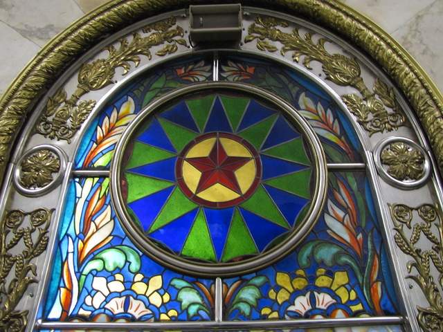
Novoslobodskaya is the Metro’s unique stained glass station. Each column has its own distinctive panels of colorful glass, most of them with a floral theme, some of them capturing the odd sailor, musician, artist, gardener, or stenographer in action. The glass is framed in Art Deco metalwork, and there is the lovely aspect of discovering panels in the less frequented haunches of the hall (on the trackside, between the incoming staircases). Novosblod is, I’ve been told, the favorite amongst out-of-town visitors.
Komsomolskaya Station
Komsomolskaya Station is one of palatial grandeur. It seems both magnificent and obligatory, like the presidential palace of a colonial city. The yellow ceiling has leafy, white concrete garland and a series of golden military mosaics accenting the tile mosaics of glorified Russian life. Switching lines here, the hallway has an Alice-in-Wonderland feel, impossibly long with decorative tile walls, culminating in a very old station left in a remarkable state of disrepair, offering a really tangible glimpse behind the palace walls.
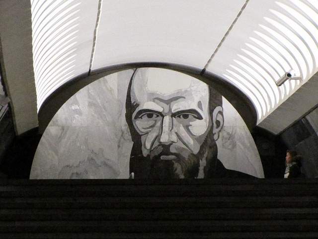
Dostoevskaya Station
Dostoevskaya is a tribute to the late, great hero of Russian literature . The station at first glance seems bare and unimpressive, a stark marble platform without a whiff of reassembled chips of tile. However, two columns have eerie stone inlay collages of scenes from Dostoevsky’s work, including The Idiot , The Brothers Karamazov , and Crime and Punishment. Then, standing at the center of the platform, the marble creates a kaleidoscope of reflections. At the entrance, there is a large, inlay portrait of the author.
Chkalovskaya Station
Chkalovskaya does space Art Deco style (yet again). Chrome borders all. Passageways with curvy overhangs create the illusion of walking through the belly of a chic, new-age spacecraft. There are two (kos)mosaics, one at each end, with planetary subjects. Transferring here brings you above ground, where some rather elaborate metalwork is on display. By name similarity only, I’d expected Komsolskaya Station to deliver some kosmonaut décor; instead, it was Chkalovskaya that took us up to the space station.
Elektrozavodskaya Station
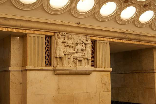
Elektrozavodskaya is full of marble reliefs of workers, men and women, laboring through the different stages of industry. The superhuman figures are round with muscles, Hollywood fit, and seemingly undeterred by each Herculean task they respectively perform. The station is chocked with brass, from hammer and sickle light fixtures to beautiful, angular framework up the innards of the columns. The station’s art pieces are less clever or extravagant than others, but identifying the different stages of industry is entertaining.
Baumanskaya Statio
Baumanskaya Station is the only stop that wasn’t suggested by the students. Pulling in, the network of statues was just too enticing: Out of half-circle depressions in the platform’s columns, the USSR’s proud and powerful labor force again flaunts its success. Pilots, blacksmiths, politicians, and artists have all congregated, posing amongst more Art Deco framing. At the far end, a massive Soviet flag dons the face of Lenin and banners for ’05, ’17, and ‘45. Standing in front of the flag, you can play with the echoing roof.
Ploshchad Revolutsii Station
Novokuznetskaya Station
Novokuznetskaya Station finishes off this tour, more or less, where it started: beautiful mosaics. This station recalls the skyward-facing pieces from Mayakovskaya (Station #2), only with a little larger pictures in a more cramped, very trafficked area. Due to a line of street lamps in the center of the platform, it has the atmosphere of a bustling market. The more inventive sky scenes include a man on a ladder, women picking fruit, and a tank-dozer being craned in. The station’s also has a handsome black-and-white stone mural.
Here is a map and a brief description of our route:
Start at (1)Kievskaya on the “ring line” (look for the squares at the bottom of the platform signs to help you navigate—the ring line is #5, brown line) and go north to Belorusskaya, make a quick switch to the Dark Green/#2 line, and go south one stop to (2)Mayakovskaya. Backtrack to the ring line—Brown/#5—and continue north, getting off at (3)Novosblodskaya and (4)Komsolskaya. At Komsolskaya Station, transfer to the Red/#1 line, go south for two stops to Chistye Prudy, and get on the Light Green/#10 line going north. Take a look at (5)Dostoevskaya Station on the northern segment of Light Green/#10 line then change directions and head south to (6)Chkalovskaya, which offers a transfer to the Dark Blue/#3 line, going west, away from the city center. Have a look (7)Elektroskaya Station before backtracking into the center of Moscow, stopping off at (8)Baumskaya, getting off the Dark Blue/#3 line at (9)Ploschad Revolyutsii. Change to the Dark Green/#2 line and go south one stop to see (10)Novokuznetskaya Station.
Check out our new Moscow Indie Travel Guide , book a flight to Moscow and read 10 Bars with Views Worth Blowing the Budget For
Jonathon Engels, formerly a patron saint of misadventure, has been stumbling his way across cultural borders since 2005 and is currently volunteering in the mountains outside of Antigua, Guatemala. For more of his work, visit his website and blog .

Photo credits: SergeyRod , all others courtesy of the author and may not be used without permission
Claudia Looi
Touring the Top 10 Moscow Metro Stations
By Claudia Looi 2 Comments

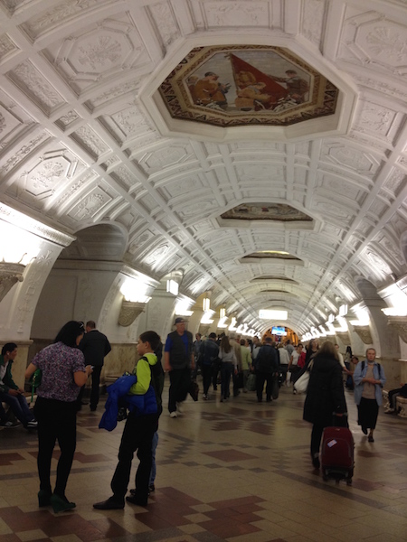
Komsomolskaya metro station looks like a museum. It has vaulted ceilings and baroque decor.
Hidden underground, in the heart of Moscow, are historical and architectural treasures of Russia. These are Soviet-era creations – the metro stations of Moscow.
Our guide Maria introduced these elaborate metro stations as “the palaces for the people.” Built between 1937 and 1955, each station holds its own history and stories. Stalin had the idea of building beautiful underground spaces that the masses could enjoy. They would look like museums, art centers, concert halls, palaces and churches. Each would have a different theme. None would be alike.
The two-hour private tour was with a former Intourist tour guide named Maria. Maria lived in Moscow all her life and through the communist era of 60s to 90s. She has been a tour guide for more than 30 years. Being in her 60s, she moved rather quickly for her age. We traveled and crammed with Maria and other Muscovites on the metro to visit 10 different metro stations.

Arrow showing the direction of metro line 1 and 2

Moscow subways are very clean
To Maria, every street, metro and building told a story. I couldn’t keep up with her stories. I don’t remember most of what she said because I was just thrilled being in Moscow. Added to that, she spilled out so many Russian words and names, which to one who can’t read Cyrillic, sounded so foreign and could be easily forgotten.
The metro tour was the first part of our all day tour of Moscow with Maria. Here are the stations we visited:
1. Komsomolskaya Metro Station is the most beautiful of them all. Painted yellow and decorated with chandeliers, gold leaves and semi precious stones, the station looks like a stately museum. And possibly decorated like a palace. I saw Komsomolskaya first, before the rest of the stations upon arrival in Moscow by train from St. Petersburg.
2. Revolution Square Metro Station (Ploshchad Revolyutsii) has marble arches and 72 bronze sculptures designed by Alexey Dushkin. The marble arches are flanked by the bronze sculptures. If you look closely you will see passersby touching the bronze dog's nose. Legend has it that good luck comes to those who touch the dog's nose.

Touch the dog's nose for good luck. At the Revolution Square station

Revolution Square Metro Station
3. Arbatskaya Metro Station served as a shelter during the Soviet-era. It is one of the largest and the deepest metro stations in Moscow.

Arbatskaya Metro Station
4. Biblioteka Imeni Lenina Metro Station was built in 1935 and named after the Russian State Library. It is located near the library and has a big mosaic portrait of Lenin and yellow ceramic tiles on the track walls.

Lenin's portrait at the Biblioteka Imeni Lenina Metro Station

5. Kievskaya Metro Station was one of the first to be completed in Moscow. Named after the capital city of Ukraine by Kiev-born, Nikita Khruschev, Stalin's successor.

Kievskaya Metro Station
6. Novoslobodskaya Metro Station was built in 1952. It has 32 stained glass murals with brass borders.

Novoslobodskaya metro station
7. Kurskaya Metro Station was one of the first few to be built in Moscow in 1938. It has ceiling panels and artwork showing Soviet leadership, Soviet lifestyle and political power. It has a dome with patriotic slogans decorated with red stars representing the Soviet's World War II Hall of Fame. Kurskaya Metro Station is a must-visit station in Moscow.
Ceiling panel and artworks at Kurskaya Metro Station

8. Mayakovskaya Metro Station built in 1938. It was named after Russian poet Vladmir Mayakovsky. This is one of the most beautiful metro stations in the world with 34 mosaics painted by Alexander Deyneka.

Mayakovskaya station

One of the over 30 ceiling mosaics in Mayakovskaya metro station
9. Belorusskaya Metro Station is named after the people of Belarus. In the picture below, there are statues of 3 members of the Partisan Resistance in Belarus during World War II. The statues were sculpted by Sergei Orlov, S. Rabinovich and I. Slonim.

10. Teatralnaya Metro Station (Theatre Metro Station) is located near the Bolshoi Theatre.

Teatralnaya Metro Station decorated with porcelain figures .

Taking the metro's escalator at the end of the tour with Maria the tour guide.
Have you visited the Moscow Metro? Leave your comment below.

January 15, 2017 at 8:17 am
An excellent read! Thanks for much for sharing the Russian metro system with us. We're heading to Moscow in April and exploring the metro stations were on our list and after reading your post, I'm even more excited to go visit them. Thanks again 🙂

December 6, 2017 at 10:45 pm
Hi, do you remember which tour company you contacted for this tour?
Leave a Reply Cancel reply
You must be logged in to post a comment.
Please go to the Instagram Feed settings page to create a feed.
IMAGES
VIDEO
COMMENTS
This short travel film follows the journey of our 10-night voyage along the remote Kimberley coastline. ... Congratulations for all aboard Coral Geographer setting sail from historic Makassar this evening. We wish you fair winds and following seas! Next stop, the tranquil Balabalagan Islands to enjoy a day of swimming, snorkelling, diving and ...
The islet sits in a lagoon with a surrounding outer reef. The coral reef to the north of Bird Islet is a sheltered coral garden which is a superb dive location. West Islet is bare coral rubble and sand only 1.8 m high. Entrance, 22°11.187' S - 155°20.877' E. Anchorage, 22°11.279' S - 155°20.926' E Obstructions within anchorage:
The Coral Sea Marine Park (CSMP) has a diverse array of habitats, such as coral reefs, sandy cays, deep sea plains and canyons. ... Most people visiting the marine park travel on live-aboard tour boats from Port Douglas, Cairns, Townsville, Mackay, Airlie Beach or Gladstone, often calling in at some Great Barrier Reef sites on the way. ...
Military History. During World War II, the Coral Sea was the site of a significant naval battle between the United States and Japan.It was a pivotal moment in the war's Pacific theatre. Whale Migration. The Coral Sea is a crucial part of the annual migration route for humpback whales.These majestic creatures travel through these waters to breeding and calving areas.
Fly over the heart of the Great Barrier Reef at Hardy Reef. Visible from space, the Great Barrier Reef stretches for over 2,300 km over an area of nearly 350,000 km 2 off the north-east coast of Australia, making it the largest coral reef system in the world. This extraordinary habitat is home to some 400 species of coral, 1,500 species of fish, 4,000 species of molluscs and 240 species of birds.
The Coral Sea Islands Territory is an external territory of Australia which comprises a group of small and mostly uninhabited tropical islands and reefs in the Coral Sea, north-east of Queensland, Australia.The only inhabited island is Willis Island.The territory covers 780,000 km 2 (301,160 sq mi), most of which is ocean, extending east and south from the outer edge of the Great Barrier Reef ...
Lying off the coast of Queensland, Australia The Coral Sea Marine Park extends from east of Bundaberg in the south to Cape York in the north. It is here that...
A 3-D bathymetric map of the Queensland Plateau in the Coral Sea Marine Park, covering more than 13,000 square miles and 30 coral reefs at depths up to 9,000 feet. Video by Schmidt Ocean Institute ...
The sea was named for its numerous coral formations, highlighted by the Great Barrier Reef, extending 1,200 miles (1,900 km) down the Australian northeast coast.Ocean shipping between eastern Australia and the South Pacific islands and China traverses the sea by way of a channel 200 miles (320 km) east of the reef. The sea has a subtropical climate and is subject to typhoons, especially from ...
Scattered over some 1 million square kilometers of ocean, the Coral Sea Islands were declared a territory of Australia in 1969. They are uninhabited except for a small meteorological staff on Willis Island. Automated weather stations, beacons, and a lighthouse occupy many other islands and reefs. These tropical sand and coral reefs and islands ...
Dive into the heart of marine conservation with our Divers Guide to Coral Reef Conservation Travel Experiences. From embracing Green Fins guidelines to selecting eco-conscious dive safaris, we equip you with tips and gear for a sustainable underwater adventure. Test your knowledge with our quizzes and explore global coral restoration efforts that are making waves. Join the movement to protect ...
The Coral Sea (French: Mer de Corail) is a marginal sea of the South Pacific off the northeast coast of Australia, and classified as an interim Australian bioregion.The Coral Sea extends 2,000 kilometres (1,200 mi) down the Australian northeast coast. Most of it is protected by the French Natural Park of the Coral Sea (French: Parc Naturel de la Mer de Corail) and the Australian Coral Sea ...
The Great Barrier Reef is the world's largest coral reef system, composed of over 2,900 individual reefs and 900 islands stretching for over 2,300 kilometres (1,400 mi) over an area of approximately 344,400 square kilometres (133,000 sq mi). The reef is located in the Coral Sea, off the coast of Queensland, Australia, separated from the coast by a channel 160 kilometres (100 mi) wide in places ...
This voyage down Western Australia's Coral coast visits the spectacular Rowley Shoals Marine Park, Dampier Archipelago and historic Montebello Islands. An exploration of the renowned Ningaloo Reef completes our voyage. Our marine experts and guides lead our discovery of this pristine coastal habitat. Departs Sept 2024 & May 2025.
Calm seas, clear skies and hardly a breath of wind. Conditions are so good for my 4-day trip to the Coral Sea aboard Mike Ball's Spoilsport, the skipper is planning 'Fair Weather' route, taking in remote Holmes Reef and Bougainville Reef, as well as Osprey Reef.And we're all pretty excited, especially at the prospect of seeing remote Holmes Reef.
Ihere is something special about seeing art and beauty while hundreds of feet underground. The metro in Moscow is breathtakingly beautiful, don't you think?
November 2022, Coral Geographer "The deeply-weathered limestone ridge of Bob's Nose loomed overhead. Our progress was watched by an Osprey mum, ensconced in her nest atop a nearby sea stack. With the Woolford brothers leading the way we made landfall and explored the vivid granite headland." - Guest Lecturer Quentin Chester
Have a look (7)Elektroskaya Station before backtracking into the center of Moscow, stopping off at (8)Baumskaya, getting off the Dark Blue/#3 line at (9)Ploschad Revolyutsii. Change to the Dark Green/#2 line and go south one stop to see (10)Novokuznetskaya Station. Check out our new Moscow Indie Travel Guide, book a flight to Moscow and read 10 ...
Revolution Square Metro Station. 3. Arbatskaya Metro Station served as a shelter during the Soviet-era. It is one of the largest and the deepest metro stations in Moscow. Arbatskaya Metro Station. 4. Biblioteka Imeni Lenina Metro Station was built in 1935 and named after the Russian State Library.
Discover New Zealand's South Island Sounds and Fiords on this 8-Night expedition voyage aboard Coral Adventurer. Delve deep into the striking landscapes of Dusky, Milford and Doubtful Sounds. Enjoy a guided walk through the forests of Ulva Island Bird Sanctuary on Stewart Island and catch sight of some of the nation's most iconic bird ...
HOME; ABOUT US; TRAVEL AGENTS; FAQ/HELP; CONTACT US; CALL US @ +7-981-863-3502; Copyright © 2000-2024 Moscow Hotels, JSC. All rights reserved.
Cruise, fly and explore with our Kimberley Explorer Package! ️ Save up to $6,000 per person ️ 10-night Kimberley expedition cruise ️ Complimentary return flights and cruise transfers ️ 1 night accommodation pre cruise with complimentary breakfast ️ Available on select dates across 2024Learn more on our website.