
Coal Mine Canyon

Coal Mine Canyon Table of Contents
Photographs.
- Access to Coal Mine Canyon
Hiking in Coal Mine Canyon
- Nearby places
- Similar places

Coal Mine Canyon Access

Coal Mine Canyon - Nearby Places
- Little Colorado River (50 miles) - deep, narrow tributary of the Grand Canyon
- Wupatki National Monument (60 miles) - Indian ruins at the edge of the Painted Desert
Coal Mine Canyon - Similar Places
- Bisti Wilderness - hoodoos and eroded hills in the desert of northwest New Mexico
- Coyote Buttes , Arizona - swirling eroded sandstone, including 'The Wave'
- Paria Rimrocks , Utah - balanced rocks and other formations near the Paria River

Coal Mine Canyon
Coal Mine Canyon is located only 70 miles from the east entrance of the most well-known canyon in the world, the Grand Canyon, yet it’s safe to say that fewer than a couple hundred visitors each year see this colorful and remote canyon. Most people have never been there, let alone heard of Coal Mine Canyon.
It almost feels like I’m betraying a close friend by sharing Coal Mine Canyon with my readers, but after much thought, I realized that it would be a shame if I didn’t share it with you.
Coal Mine Canyon Hike Details
Distance – 0.5 to 3 miles, depends on the amount of exploring you do Approximate hiking time – 1.0 to 2.5 hours Elevation at trailhead – 5820 feet Elevation down on canyon floor – 5456 feet Elevation gain – 364 feet Difficulty – Moderate to Strenuous Trail – None Amount of water recommended – 2 to 3 liters, there is no shade Bathrooms – None Seasons to hike – Year around Permits: None needed for access on Hopi and Navajo reservation lands
How to get there:
From Flagstaff, AZ, head north on US-89 for 62.5 miles. Turn right onto US-160. Head east for 10.3 miles to Tuba City, AZ. Turn right onto AZ-264 (Main Street). Head southeast on AZ-264 for 15.1 miles. At around 15 miles down AZ-264 look to the left and about a half a mile off the road you should see an old windmill, shortly after you pass green mile marker 337, look for a turnoff to the left. The turnoff will be paved until you cross a cattle guard, and as of 2012, it was a dirt road from that point on. The road will fork just past the cattle guard. Take the right fork, and aim for the windmill. The dirt road will go left leading to the windmill. Pass the windmill and continue east for a couple hundred feet. A gravel parking area with a couple of concrete picnic tables will be visible. Park here. (Drive time is about 90 minutes)
From Page, AZ, head south on US-89 for 66 miles. Turn left and head east for 10.3 miles to Tuba City, AZ. Turn right onto AZ-264 (Main Street). Head southeast on AZ-264 for 15.1 miles, and then follow the rest of the directions above from Tuba City to Coal Mine Canyon. (Drive time is about 90 minutes.)
You can also come from Moab, UT, however it is more than a four hour drive. I’ve come from both Moab and Page, and I would recommend waiting until you were down in the Kanab/Page area to go down to Coal Mine Canyon.
Hitting the Trail!
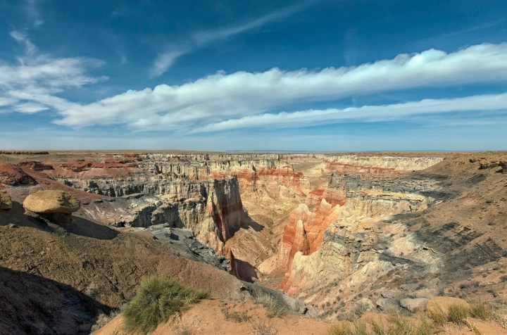
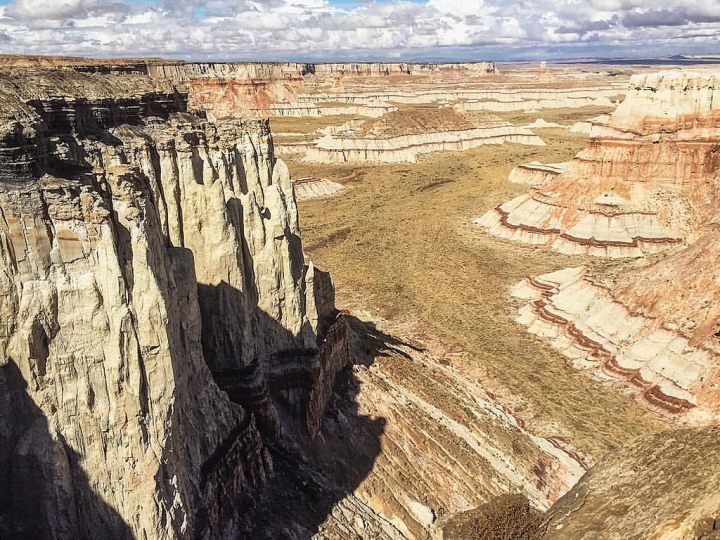
As you leave the parking area, walk past east past the concrete picnic tables and before your eyes, Coal Mine Canyon will appear seemingly out of nowhere. It is six miles long by six miles wide at its largest. The canyon has amazing orange, red, pink, and black colors. A thin layer of black coal is visible along the canyon cliff walls. This is on both Hopi and Navajo reservations lands, and range cattle graze freely along the some parts of Coal Mine Canyon, so watch out for cow pies near the parking area.
There are no marked trails that lead from the lip of Coal Mine Canyon down to the canyon floor. However, there are several ‘fingers’ of the canyon wall that you can attempt to go down, but several are just too sheer to drop down. Choose wisely if you decide to descend. It can be dangerous. I found one finger that looked promising and picked my way down. Basic canyoneering/climbing skills are necessary, and those with a fear of heights may have a difficult time with the initial descent. After dropping down the first couple hundred feet, the going gets much easier down to the canyon floor. I never found any established trails, but I have heard that game trails can be found from time to time.

One doesn’t need to descend the canyon to appreciate the beauty. The colors are magnificent. Take time to walk around the rim, but don’t get too close because the lip of the rim is very weak and unstable. Everywhere you look, you’ll want to take several pictures.
I have been to Coal Mine Canyon three times. Once with a friend, and the other two times were solo trips. Besides my friend, I’ve never seen anyone else at the canyon. It felt like MY canyon.

Early morning shot of Coal Mine Canyon
There are also different vantage points from which you can enjoy Coal Mine Canyon. If you get back onto AZ-264 and continue to head southeast, you will see a large black top turnabout on the left side of the highway, directly across from a green road sign that reads Hotevilla 27 miles and Keams Canyon 63 miles. Turn left here. Once again the road quickly turns to dirt after passing a cattle fence. This dirt road will split a couple of different times, but seemed to merge back together after a short time. This road skirts Coal Mine Canyon to the left and another canyon to the right.
Stop periodically along the way to walk close to the edge and snap some pictures. It presents a unique angle of Coal Mine Canyon than what you saw at the first place. You’ll soon find that the rim of the canyon just drops a couple of hundred feet to the canyon floor. There really are no ‘fingers’ to use to climb down to the floor from here. Once again, be careful and stay away from the very edge, the brittle rock will give way.

Once you’ve reached this little abandoned hut, you can turn around and head back since the views aren’t as impressive past the little building
You can choose to follow this dirt road as long as you’d like. Each viewpoint will give you a different perspective. They road will dead-end and peter out, so I would recommend turning around at an a circular, abandoned building since there isn’t really anything else of interest from that point. You’ll know what building I’m talking about because it is the only thing out there. You can’t miss it.
After taking hundreds of pictures, I headed out the way I came, got back on AZ-264 and headed northwest back to Tuba City, AZ. It is a whirlwind trip, but you can visit Coal Mine Canyon and the south rim of the Grand Canyon in the same afternoon with relative ease. Be sure to visit the Little Colorado River Overlook as you make your way to the Grand Canyon from Coal Mine Canyon.
For upcoming hiking and survival posts, connect with me on Instagram and the Your Hike Guide Facebook page

This view is from the cliff edge looking down towards the route I took to reach the canyon floor

Adam Provance at the edge of Coal Mine Canyon
FREE Packing List:

Download for Free
Share this:
- Click to share on Twitter (Opens in new window)
- Click to share on Facebook (Opens in new window)
About Author

Adam is an experienced hiker and canyoneer, who has visited some of the most breathtaking and remote places in the United States. As an instructor for Desert and Wilderness Survival, and for Leave No Trace camping practices, he shares his passion and respect for the outdoors to all. Adam is currently a Scoutmaster in the Boy Scout of America, and is an Eagle Scout. As the founder of www.yourhikeguide.com, his goal is to educate others on the joys of hiking.
Related Posts

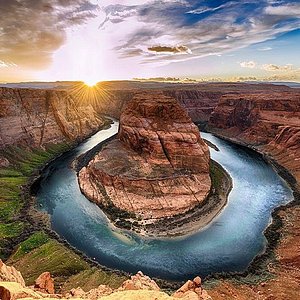
Antelope Canyon

Horseshoe Bend

Kanarra Creek Falls
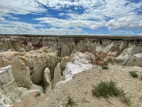
When I checked with the Navajo Nation recently I learned that it’s ok to camp there if you have a permit but that hiking into the canyon is forbidden now. We first learned of Coalmine Canyon in 1981 and, in those days, we hiked in the canyon numerous times. The hoodoos are spectacular and are supposed to “move” and look spooky when viewed in summer at full moon.
Is camping allowed anywhere around the canyon and how safe is it?
Dave, Camping at Coal Mine Canyon would definitely be magical! Since Coal Mine Canyon is on Navajo land, any type of camping would require a Navajo permit/permission. As far as safety, there are no facilities nearby, and it’s rather remote with limited to no cell phone reception. However, here’s a good website to find additional information on camping permits on Navajo land. http://navajonationparks.org/permits.htm
Thanks for the info. Since I last posted, I have been in touch with the Navajo Parks that manage this area and have downloaded the form for a hiking permit. It seems that the rim of the canyon is Navajo but the canyon itself is Hopi. The Navajo permit was easy and the office personnel there were great. I have been a little thwarted in getting information from the Hopi. No one, so far, was able to tell me if a hiking permit was required or even where I could get one. They did suggest that I hire a guide. For the three or so hours to make the hike, I am not certain if we will go that route, even though I want to get to the bottom of the canyon. We’ll see.
I have had more than one Navajo recommend against camping on the rim, for safety reasons. Still debating! Your thoughts?????
Hopi’s by their nature are more,how to put this, respectful of their land and traditions. They have limited tourist infrastructure and it is all on an “island” reservations (Moenkopi) next to Tuba City (small casino – of course and a fairly nice but expensive hotel). Once you are on the main reservation there are a few galleries and one hotel near Second Mesa (but I don’t know if it is still running). Some Hopi villages still do not (by choice) have electricity. a few solar panels have gone up and propane serves heating and cooking. So it doesn’t surprise me at a lack of response from the Hopi’s.
Missed your camping question and this may be too late. But not more than a few 100 yards to the east of the turnoff that Adam indicates. there is the Coal Mine Mesa Chapter House on the south side. Think of it as a township one stop shop. if you get there mid-afternoon go up and ask about the safety. And indicating you will be over there for the nght would be a good idea anyway. Also when i was just there Monday (7/20/2014) i took a late afternoon nap. I heard an ATV rustling around and someone came by to check things out. I would approach the farm house (one of the few 2 story house you will ever see on either reservation) on the ridge to the west (about 200 yds) and “check in” with them. Tell them your intentions so they know you aren’t out there meeting up for an alcohol deal or drugs. It would not surprise me if he is not an unofficial caretaker/watcher. Despite warnings to the contrary in 30 years I have never had a problem on either reservation….have left car unattended but locked for hours at a time….but my camping has always been in developed areas….and this is remote….other than the really big house right next door!
Pingback: Being a Good Traveler: Coal Mine Canyon
Coal Mine Canyon
About twenty miles southeast of Tuba City, Arizona sits a remote canyon at the edge of the Painted Desert. The sprawling gorge is home to colorful badlands, painted rock spires and hoodoos. Spanning Navajo Nation and Hopi Reservation land, it’s an isolated treasure where you can enjoy a small piece of the southwest desert in complete solitude. While its more famous neighbor to the west, the Grand Canyon, receives upwards of six million tourists a year, Coal Mine Canyon sees just a few hundred visitors. If you’re looking to get off the beaten track and explore a bit of secluded, undisturbed beauty, this is a pretty special little place.

There aren’t many hiking options without a native guide and permit, but the few backcountry roads that skirt the rim offer some lovely vistas. Our favorite spot was a viewpoint along the northern end of the canyon. We found some advice online that directed us to an unsigned dirt road off Highway 264 near mile post 337. The rough track lead us out to a lone windmill and water tank, the supposed endpoint. As we got out of the car and began to wonder where the heck we were, we spotted a few picnic tables perched beside the canyon’s rim. We walked over, lunch and cameras in hand, and soaked in the view. It was like a little gift for the rare rover who decides to venture out into the middle of nowhere. It really was the greatest little picnic spot.

About 3.5 miles further south on the rim (near mile post 340) we headed for a place called Blue Point. We again turned off onto a dirt road, driving about a half mile off the highway before stopping at the edge of a flat mesa. We noticed that the road dropped precipitously down the edge of a steep bluff, and got out to inspect the route. Recent rains had created about eighteen inches of thick mud on the hillside, and we knew there’d be no chance in hell of getting the Subie back up out of that mess if we tried to drive down. With that, we threw the car into park and decided to just hoof it down the road to check out the views.
We walked for about three miles down the road, intermittently wandering to the edge of the rim, before deciding to head back to the car. We were ankle deep in the most insane, cement-like sludge, and our hiking boots felt like they were carrying an extra five pounds on each foot. Although it was a scenic ravine, we weren’t really feeling it was worth the fourteen-ish miles round-trip. If conditions are dry and the road passable, you can supposedly drive for about seven miles from the top of the mesa (per Google Maps) until the road fades at the edge of the canyon. That said, you’ll probably still need an AWD vehicle with decent clearance, as that first descent is a doozy.

While our impromptu slog through the mud ate up most of our afternoon, it looks as if there are a couple spots to access the rim six to eight miles further south along Hwy 264 (near the southern tip of the canyon). It was a nice enough day that we’d definitely consider a return trip.
If you’re interested in getting out and exploring a more remote canyon that’s well off the beaten path, Coal Mine Canyon is a great place to enjoy some solitude and stunning scenery. The views along the rim are quite impressive, and roaming around the top of the canyon makes for a nice half-day of exploring in itself.

Coal Mine Canyon straddles the Navajo and Hopi Reservations in eastern Arizona. The rim is part of Navajo Nation while the interior is part of the Hopi Reservation. If you want to explore down inside the canyon, you’ll need a special permit as well as the company of a Hopi guide. To explore the rim by car or on foot, you will need a Navajo Nation backcountry permit . Permits are $12 and can be purchased in-person at the Navajo Parks & Recreation Office in Cameron, Arizona or over the phone by credit card.
- About Author
- Latest Posts

Latest posts from Jenn
- Shoulder season hikes in the Canadian Rockies - April 4, 2024
- A Guide to Winter Photography in Banff National Park - April 3, 2024
- Wild Ice: Perfection at Peyto Lake - April 1, 2024
Recent Posts

Shoulder season hikes in the Canadian Rockies

A Guide to Winter Photography in Banff National Park

Wild Ice: Perfection at Peyto Lake

Mount Burke

Sulphur Mountain (Sanson Peak)

Ha Ling & Miner’s Peak

Mount Andromache

Little Arethusa
Leave a reply cancel reply.
Your email address will not be published. Required fields are marked *

Username or Email Address
Remember Me
- About the Blog
- Travel Tips
- Sanchez’ Corner
- Around the World 2016
- Australia & Oceania
- North America
- South America
Coal Mine Canyon

Location & Hours
Suggest an edit

Tuba City, AZ 86045
You Might Also Consider

Grand Concierge
Discover the beauty of Sedona and the Grand Canyon in style with our top-of-the-line fleet of vehicles, driven by professional and knowledgeable stewards who prioritize your comfort, safety and impact. Whether you're planning… read more
in Wine Tours, Travel Agents

Flagstaff Private Car Service & Tours
Chachell T. said "We found ourselves at the airport unable to grab a cab or other ride share services. My husband found Flagstaff Private Car Service that was happy to help us. We were greeted by Jasmine and she took care if us and made sure we…" read more
in Limos, Tours, Airport Shuttles

Grande River Vineyards
Grande River Vineyards is Colorado's Premium Winegrowing Estate and Gateway to Colorado's Wine Country. We are growers and makers of premium Colorado Grown wines in traditional styles. Visit our friendly and informative tasting room… read more
in Party & Event Planning, Wine Tasting Room, Wine Tours
Recommended Reviews
- 1 star rating Not good
- 2 star rating Could’ve been better
- 3 star rating OK
- 4 star rating Good
- 5 star rating Great
Select your rating
Overall rating

Beautiful view of Coal Mine Canyon. Located about 15 miles southeast of Tuba City. If you go please be respectful of the property and livestock. Place has a great history and folklore. You can see the coal seam in the rock. There are a few picnic tables and cooking grills. No signs and few people. The person who maintains the area lives nearby. There is no fee but donations are always appreciated. You may even be lucky enough to hear a story about living near this natural scenic wonder.

Are you tired of being surrounded by many tourists in Grand Canyon, Monument Valley and Antelope Canyon? If you are in that area, I highly recommend that you take a short side trip to "Coal Mine Canyon" in Tuba City. Coal Mine Canyon is not in most of guidebooks so you can enjoy the colorful canyon and the solitude. It is in the Navajo land and it is close to the eastern edge of Painted Desert. There is absolutely no sign to tell you where the canyon is so here is how to get there. 1. Drive to Tuba City on Route 160 2. There is only one major intersection in the city and from there, take Route 264 "South" 3. Drive about 15 miles or if you don't want to count the miles, drive your car at 60 mph for about 15 minutes. 4. You will see one new house and one windmill on your left. (Don't worry! These are the only structures around this area) 5. Turn left to the gravel road to go to the side of the house. 6. Park your car near the ruin of the old house after passing by the new house and walk to the rim of the canyon. When I got there with two other friends around 11:00 am, there was no other tourist. We enjoyed the canyon by walking around the rim for about an hour as if we had owned it. It was so quite and relaxing, just the sound of wind and the sound of a friend of mine urinating. If you have a chance to visit northern Arizona, I highly recommend you visit this hidden place!

A little known place and hard to find if you didn't know where it is located. Very beautiful and undeveloped. There is a small area with picnic tables. The trails are not marked. Best time to go is just before sunset the colors change every minute.

Luxurious Coach
We offer professional, courteous and affordable black car and SUV Services. Our drivers have years of reliable service to their credit. We cater for special events such as weddings, concerts, corporate gatherings and other special… read more
in Public Transportation

Angry Ape Off-Road
We offer mild & scenic, to wild & hang on to your shorts off road adventure tours in the Prescott National Forest. We take you places in the forest many never get the opportunity to see in the comfort of one of our Hummer H3’s. Come… read more
People Also Viewed

The Grand Canyon Visitor Center

Grand Canyon National Park

Little Colorado Scenic Overlook

Dinosaur Tracks

Tusayan Museum And Ruin

Navaho National Monument

Moran Point

Desert View Watchtower

Pink Jeep Tours - Grand Canyon

Verkamp’s Visitor Center
Best of Tuba City
Things to do in Tuba City
Other Places Nearby
Find more Landmarks near Coal Mine Canyon
Find more Tours near Coal Mine Canyon
Browse Nearby
Restaurants
Campgrounds
Landmarks & Historical Buildings Near Me
Mines Near Me
Places to Visit Near Me
Tours Near Me
Related Cost Guides
Town Car Service
Coal Mine Canyon

Top ways to experience nearby attractions
Most Recent: Reviews ordered by most recent publish date in descending order.
Detailed Reviews: Reviews ordered by recency and descriptiveness of user-identified themes such as waiting time, length of visit, general tips, and location information.
Coal Mine Canyon - All You Need to Know BEFORE You Go (2024)
Coalmine Canyon Chapter
Coalmine canyon rules & regulations, coalmine canyon.
Coalmine Canyon lays on the border of the Navajo Nation and Hopi Tribe. Be aware both Tribes have different rules and regulations regarding the canyon. The Navajo Nation occupies the western portion of the Canyon while the Hopi Tribe occupies the eastern portion.
Directions to picnic area from Coalmine Canyon Chapter House
From the former Chapter House drive north to HWY 264. At the junction turn west. Stay on HWY 264 for 1.16 miles. On the right-hand side there is a dirt road turn off that runs along a barbed wire fence which will lead to the canyon.
Coalmine Canyon Location Map
Please click the link to see the map to the Coalmine Canyon and where the Navajo and Hopi boundaries are.
Contact Information:
Na vajo Nation Police – Tuba City District
Tuba City Regional Health Care Corporation Trauma Center
Tuba City Fire Department: 928-283-3111
Coalmine Canyon Chapter: 928-280-0700
Cameron Visitors Center- Navajo Parks & Recreation: 928-679-2303
Rules & Regulations
Coalmine Canyon West is a Navajo Nation Tribal Park. Therefore, these Rules & Regulations apply.
- Stay on designated trails and routes. Cutting switchbacks damages trails and causes erosion and destruction of soil composition. It can take 100 years for soil and vegetation to recover from human impact.
- Respect the privacy and customs of the Navajo people. Do not wander across residential areas or disturb property. Obtain permission before taking pictures of the Navajo people.
- Whatever you pack into the wilderness, you must carry out. Nothing should be left, buried, or burned. Substances such as food scraps and garbage will take years to decompose and wildfires can be started by burning trash.
- Pets are allowed ONLY if on a leash at all times. The backcountry is open range for livestock.
- Photographs or video taken for commercial use is prohibited unless accompanied by a valid permit issued by Navajo Parks & Recreation or Navajo Office of Broadcasting Services.
- Navajo Tribal Code Title 17, Section 1451, prohibits the use of firearms.
- The Navajo Nation is not responsible for any injuries, accidents, or thefts of personal property during your visit.
- Fires are permitted only in grills, fireplaces, or similar control devices. No open ground fires. There is always a danger of wildfires.
- Do not disturb or remove animals, plants, rocks, or artifacts. Tribal Antiquity and federal laws are in effect. Special permits are required from the Navajo Minerals Department and Natural Heritage Program to collect rocks or plants.
- Consumption and/or possession of alcoholic beverages or illegal drugs are prohibited.
Vehicles: The Navajo Nation is not responsible for any theft or accidents during your visit. Parking your vehicles in isolated areas will not be monitored or surveillance. You may, however, obtain permission to park your vehicles at local residence. They may request a small fee.
Off-road Travel: Dune buggies, jeeps, 4-wheel drive vehicles and motorcycles are prohibited off established trails and on roads. Unnecessary trails or roads result in erosion to the fragile environment.
Hiking & Camping Rules
The Navajo Nation is comprised of more than 25,000 square miles and offers hikers numerous isolated trails and routes. For the safety of hikers who enter the reservation and for the protection of natural and cultural resources, the Parks and Recreation Department has implemented guidelines for backcountry use.
The trails are not improved or maintained and are usually marked with rock claims. To reach the trailheads, topographic maps and drives over rough roads are required. Roads can become impassible in wet weather, and conditions can change quickly. Travelers are cautioned to be prepared. To ensure having an enjoyable experience, plan your trip carefully. Most trails are rated strenuous to moderately strenuous, and good physical conditioning is important. Many Navajo families still live on the reservation annually. Please be respectful of homesites and animals in these areas. The terrain is rough, water is scarce, and the weather is often extreme in most areas.
In summer, the trails are hot and dry; in winter, elevations make them subject to severe cold and high winds. Due to the quick changes in the weather, be aware of the dangers of flash floods. While this danger is greatest during the summer monsoon season (July through September), flash floods can occur at any time of the year.

Home > Road Trip Itineraries > West Coast > Arizona Road Trip Itineraries > Coal Mine Canyon: Discovering A Natural Wonder in Arizona

Coal Mine Canyon: Discovering A Natural Wonder in Arizona
This site may contain affiliate links. We may receive a commission for purchases made through these links.
To say that the West Coast is a land of wonders may seem cliché. Nature parks such as Monument Valley , Grand Canyon , Bryce Canyon have now become common knowledge for travelers from all over the world, and are often featured in nature documentaries. But we truly believe that the West Coast is full of secrets, and for this reason, we do not get tired of exploring it in search of new destinations in nature that are not as famous and, as a result, are excluded from classic itineraries, but are still absolutely worth visiting at least once in a lifetime.
Today we want to draw your attention to Coal Mine Canyon , an incredible hidden gem in Arizona we’ve been wanting to tell you about for a long time that will blow your mind. The colorful Coal Mine Canyon is not far from the Grand Canyon, but most travelers have never even heard of it. Although it’s quite easy to get to it, it seems that only 200 visitors come each year ! It’s one of those destinations that you would secretly recommend to a friend of yours who goes there, and that’s why it’s worth talking about it here. We will give you all the info you need to visit this beautiful canyon .
What Is It?
Do you need a permit, coal mine canyon view point (north), blue point (south), can you hike on trails, the best time to go and where to stay, photo gallery.

Coal Mine Canyon is located halfway between the Navajo Nation (north) and the Hopi Reservation (south). A permit is required to visit the canyon (cost $12 in 2020), available from the Navajo Parks & Recreation Office in Cameron, or online . There are no visitor centers or rest areas in Coal Mine Canton and you need to protect yourself from the heat .
How to get to Coal Mine Canyon? Map and Directions
The entrances to the Coal Mine Canyon are on State Route 264. The landmark on the route is Tuba City, a town on the road between Page , Grand Canyon and Monument Valley , which makes it a strategically perfect place for an intermediate stop.
- Coming from Page (north) takes 1 hour and 15 minutes (via US-89 N)
- Coming from Kayenta (east) it takes 1 hour and 25 minutes (via US-160 W)
- Coming from Grand Canyon Village (west) takes 1 hour and 45 minutes (via SR-64 E and Desert View Drive)
- Coming from Flagstaff (south) it takes 1 hour and 30 minutes (via US-89 N).
Since there are no paved roads in the accessible part of Coal Mine Canyon, you may be wondering if you can drive on the canyon roads in your car (or rental car ), or if it would be better to use a 4×4. Clearly, an off-road vehicle is ideal, but the road does not present any particular problems for those with cars that are lower to the ground. Obviously, if it has rained in the last few days, then it’s not possible to drive on these roads. If that is the case, you will have to give up visiting Coal Mine Canyon.

From Tuba City, drive southeast for 16 miles until you reach a fork on the left after mile marker 337 on SR-264. The road is unpaved and leads to a windmill , which you must use as a point of reference, since there are no other signs. Pass in front of the windmill or – if you find cattle standing in the road like we did – go around the windmill on the road immediately on the right. A few yards later you will find a clearing with a picnic table. Park there and reach the observation points on foot.

It is also possible to access the southern section of the canyon, where you can reach observation points that are even more remote and more beautiful . The area is known as Blue Point . To get there, get back on the SR-264 and continue south for another 3 miles, turning left at a green sign that displays the distances to Hotevilla and Keams Canyon . Here too you will find a dirt road that passes between two ridges.

You can travel on this road for as long as you wish or until you get tired of the scenery. However, there are no signs, and you won’t even find obvious landmarks or picnic areas either. When you see an observation point that strikes you as interesting, leave your car along the road and walk to the edge of the canyon. On the map above you can also see the end of the route . When you reach it, I suggest that you turn around, because there is not much else to see.

As for Blue Point , it’s a different story. As I have already mentioned, you’ll have to follow a dirt road that crosses through the middle of a mesa , passing through of two sections of the canyon. Once you stop the car at the point that I recommended, you can get closer to the ridge to take some pictures or admire the wonderful view. Also in this case, you will not be able to go down into the canyon for the same reason mentioned above.

The best time to see Coal Mine Canyon is at dawn , but to get there on time, you’ll need to stay overnight in Tuba City . Here’s a list of hotels in the area.
The town has no tourist attractions, but it’s the closest place to your destination, and it’s also a suitable solution if you’re wondering where to stay between Grand Canyon and Monument Valley . Alternatively, you can consider other towns that are a bit further away and some are more pleasant than Tuba City:
- Hotels in Kayenta
- Hotels in Page
- Hotels in Flagstaff

Warning: Operating hours can change and closures for extraordinary events can occur, so we strongly suggest to check the venues official websites.

Bernardo Pacini
I am an enthusiastic traveler. I have also published some poetry. Besides traveling, my interests include literature, prog music and good food,.
Related posts

White Pocket in Arizona: a marvel in the Vermillion Cliffs National Monument

The Wave in Arizona – A Complete Guide to get your Permit

Things to Do in Kolob Canyons, a beautiful and remote area of Zion National Park

The Incredibile History of Zzyzx, California
2 thoughts on “coal mine canyon: discovering a natural wonder in arizona”.
Hello and thank you for your information. I had read that a camping permit is obtainable from the Cameron office. I would like to camp somewhere along the rim past the picnic area or along Blue Point. Can you confirm if this is legal with a permit and if so, where might be the best place to camp for sunset and sunrise photography? Many thanks for your response.
Hello! Actually, the Blue Point area falls under Hopi jurisdiction, so you should inquire with their departments rather than the Navajo. Unfortunately, we don’t have precise information on the rules for that area, but as far as we know, a permit is required to enter the canyon, not necessarily to stay on the top.
Leave a Comment Cancel reply
This site uses Akismet to reduce spam. Learn how your comment data is processed .
There’s A Little Known Unique Canyon In Arizona And It’s Truly Stunning

Monica Spencer
Monica is a Diné (Navajo) freelance writer and photographer based in the Southwest. Born in Gallup and raised in Phoenix, she is Tódich'ii'nii (Bitter Water People) and Tsi'naajinii (Black Streak Wood People). Monica is a staff writer for Only In Your State, photo editor for The Mesa Legend, and previously a staff writer for The Navajo Post. You can reach her at [email protected].
More by this Author
One of the things I love most about northern Arizona are all the hidden gems sitting just out of view to the average traveler. However, if you ask around and know where to look, you can find some really cool places that most people don’t even know exists. That happens to be the case with this beautiful canyon we’re going to look at today.
Related Stories

The Incredible Salt Cave In Arizona That Completely Relaxes You

There's No Place On Earth Like This Incredible Cave House In Arizona

11 Little Known Canyons That Will Show You A Side Of Arizona You’ve Never Seen Before
Coal Mine Canyon is located approximately 16 miles east of Tuba City via State Route 264 . Since it is located within the Navajo Nation, you will need to obtain a permit to visit the canyon. Visit the Navajo Nation Parks and Recreation website for details about contacting the Cameron Visitor Center. Hikes down into the canyon can be arranged through the Hopi Tribe; visit experiencehopi.com for details.
Wow, that was one stunning place! If you want to check out another fantastic canyon that sees relatively little foot traffic, check out our article about Aravaipa Canyon in southern Arizona: This Underrated Canyon Just Might Be The Most Beautiful Place In Arizona .
OnlyInYourState may earn compensation through affiliate links in this article. As an Amazon Associate, we earn from qualifying purchases.
Want more Arizona in your inbox?
Get the latest on things to see, do, and eat around Arizona!
Thank you! You'll receive your first newsletter soon!
An error occured.
Related Articles
- Someone Flew A Drone High Above Arizona And Captured The Most Breathtaking Footage
- One Of The Best Views In America Is Found Right Here In Arizona
- This One Spot In Arizona Should Be The 8th Wonder Of The World
- This Stunning Timelapse Video Shows Arizona’s Grand Canyon Filled With A Sea Of Clouds
- The World’s Largest Meteor Crater Is Right Here In Arizona And It’s Truly Remarkable
- Here Are 12 Incredible Things You Need To See And Do At Arizona’s Grand Canyon
- Some Of The Most Breathtaking Views In America Can Be Found Right Here In Arizona
- This Controversial Walkway Offers An Unforgettable View Of Arizona’s Grand Canyon
Explore Arizona
- National & State Parks
- Natural Wonders
- On the Water
- Parks & Gardens
- State Parks
Storytelling helps us share our experiences with the world, and we have so many experiences that we want to share! From interviews with participants, site directors and Amizade staff members to the latest news about our programs, you can always find an interesting story to read on the blog.
Coal Mine Canyon: A Hidden Wonder in the Navajo Nation
Home > Blog > Coal Mine Canyon: A Hidden Wonder in the Navajo Nation
by Amizade Global Service-Learning

Coal Mine Canyon is a branch of the Grand Canyon. The canyon gets its name from the from the fact that it was once mined for coal. The coal proved to be of poor quality, so the mining was abandoned. However, remnants of a mining past can still be seen along the top edges of the canyon walls, where a clear contrast exists between rock that has been carved out through mining and drilling, and rock that has been shaped by water and wind. Though Coal Mine Canyon is not as large or deep as the Grand Canyon, its incredibly intricate rock formations make the canyon an equally breathtaking view. One of the most striking aspects of the canyon are the brilliant colors, warm red and yellow, that radiate from the rocks. These colors become even more vivid at sunset, the time that Amizade volunteers visit and marvel, as the reddening sun begins to rest over the desert horizon.

To learn more about the opportunity to serve and learn in Navajo Nation, click here !

Subscribe to our blog
- Your email *
Connect with Us
- Amizade on Facebook
- Amizade on Instagram
- Amizade on Twitter
- Amizade on LinkedIn
- Amizade on YouTube
Amizade turns 30 this year! Join us in Pittsburgh on September 14th.
Privacy Overview
- United States
Hike Coal Mine Canyon
Tuba City, Arizona
Elevation Gain
Out-and-Back
Description
Added by Kevin Kaminski
Explore amazing rock formations, hoodoos, and enjoy great photography opportunities. This hike can be as little as 1 mile and up to 3 miles. The trailhead elevation is 5820 feet and the canyon floor is 5456 feet.
Coal Mine Canyon is a remote gem of the southwest that borders the Hopi and Navajo Indian Reservation. Coal Mine Canyon is located about 15 miles from Tuba City Arizona, The access to the canyon is off of Hwy 264 between mile marker 337 and 338 (right around 337.25). Once you make the turn off you will be on a dirt road the rest of the time, no need for four wheel drive vehicles. Once on the Dirt road you can drive to a parking area that passes a windmill and water tank, ending at a parking area near some picnic tables. I ended up not driving to that area, rather I just parked off to the side of the road and went exploring to the right and left sides of the canyon. Once you reach the Canyon rim you are introduced to the array of eroded spires, hoodoos, gullies, cliffs, of every color imaginable. Coal Mine Canyon gets it’s name because of the coal deposits spread throughout the canyon, the rim of the canyon is soft and crumbly with thin layers of Dakota sandstone. The red, white, black and gray colors found in the canyon are from the Entrada Formation, the red layers are from coloration of shale due to partial burning of the underlying coal.
Hiking at Coal Mine Canyon can be done but theres no direct path into the canyon, faint trails lead east and west along the rim and to some ridges that project outward “these have the best views”. You can see some trails on the canyon floor from the rim but again finding the route down can be hard, and also a permit may be requited to hike down into the canyon. Coal Mine Canyon is a great place to explore with virtually no crowd at all, its also an amazing opportunity for photography, and a place you can spend the night camping. For camping or hiking into the canyon permits you may need to contact Navajo or Hopi Nation, hiking along the rim requires no permit. Call +1 (928) 679-2303 for more info.
Download the Outbound mobile app
Find adventures and camping on the go, share photos, use GPX tracks, and download maps for offline use.
Hike Coal Mine Canyon Reviews
Leave no trace.
Always practice Leave No Trace ethics on your adventures and follow local regulations. Please explore responsibly!

Explore Blue Canyon

Photograph Elephant's Feet

Hike the Wupatki Pueblo Trail
")
Grand Falls (CLOSED)

Camp at Desert View Campground
- Local Adventures
- Tours and trips
- Camping Nearby
- Outbound PRO Membership
- Add your property
Mobile Apps

© 2024 The Outbound Collective - Terms of Use - Privacy Policy
- © Roadtrippers
- © Mapbox
- © OpenStreetMap
- Improve this map

Coal Mine Canyon
Az Hwy 264 15 miles south-east of Tuba City, Tuba City , Arizona USA
- Independent

Reviewed by Nancy Sewell
- 1,228 Reviews
- 414 Helpful
Coal Mine Canyon, which is just off the road between Tuba City and Kykotsmovi, is one place where you’ll feel completely separated from the rest of the world. Plus, it helps that this place is 105% gorgeous.
Visiting information: Navajo Nation Parks & Recreation

Reviewed by mindemullinax
Gorgeous and secluded! You will feel like you have the place all to yourself (because you probably will!). It’s a definite must see on the way to the Grand Canyon. From the softness of the sand under your feet, the luster of the surrounding rock, and the abundance of color in the walls of the Canyon, this place is MAJESTIC!
Be the first to add a review to the Coal Mine Canyon.
Problem with this listing? Let us know .
Has RV parking changed? Let us know .
- Unavailable Parking
- Unknown Pets Allowed
- Unknown Restrooms
- Unknown Wifi
- Unknown Wheelchair Accessible
- Unknown Credit Cards Accepted
Nearby Hotels
Click to discover a great deal!
Related Trip Guides
The top things to do on an i-40 road trip, the top things to do on an i-10 road trip, the ultimate guide to petrified forest national park, the ultimate guide to grand canyon national park, keep exploring with the roadtrippers mobile apps..
Anything you plan or save automagically syncs with the apps, ready for you to hit the road!
Connect with us and hit up #roadtrippers
Tall tales, trip guides, & the world's weird & wonderful.
- Roadpass Digital
- Mobile Apps
Business Tools
- Partnerships
Get Inspired
- Road trip ideas by state
- National parks
- Famous routes
- Voices from the Road
Fresh Guides
- The ultimate guide to Mammoth Cave National Park
- The Ultimate Guide to Badlands National Park
- Route 66 Leg 2: St. Louis to Tulsa
- Route 66 Leg 1: Chicago to St. Louis
- Route 66 Leg 3: Tulsa to Amarillo
- Top 10 things to do in Ohio
- Offbeat Road Trip Guides
- Road Trip USA
- Scenic Routes America
- National Park Road Trips
- Terms and Conditions
Coal Mine Canyon
Top ways to experience nearby attractions
Most Recent: Reviews ordered by most recent publish date in descending order.
Detailed Reviews: Reviews ordered by recency and descriptiveness of user-identified themes such as waiting time, length of visit, general tips, and location information.
COAL MINE CANYON: All You Need to Know BEFORE You Go (with Photos)
Coal Mine Canyon
Top ways to experience nearby attractions
Most Recent: Reviews ordered by most recent publish date in descending order.
Detailed Reviews: Reviews ordered by recency and descriptiveness of user-identified themes such as waiting time, length of visit, general tips, and location information.
Coal Mine Canyon - All You Need to Know BEFORE You Go (2024) - Tripadvisor
Red state coal towns still power the West Coast. We can’t just let them die

- Show more sharing options
- Copy Link URL Copied!
In the early morning light, it’s easy to mistake the towering gray mounds for an odd-looking mountain range — pale and dull and devoid of life, some pine trees and shrublands in the foreground with lazy blue skies extending up beyond the peaks.
But the mounds aren’t mountains.
They’re enormous piles of dirt, torn from the ground by crane-like machines called draglines to open paths to the rich coal seams beneath. And even though we’re in rural southeastern Montana, more than 800 miles from the Pacific Ocean, West Coast cities are largely to blame for the destruction of this landscape.
Workers at the Rosebud Mine load coal onto a conveyor belt, which carries the planet-wrecking fuel to a power plant in the small town next door. Plant operators in Colstrip burn the coal to produce electricity, much of which is shipped by power line to homes and businesses in the Portland and Seattle areas. It’s been that way for decades.
“The West Coast markets are what created this,” Anne Hedges says, as we watch a dragline move dirt.

She sounds frustrated, and with good reason.
Hedges and her fellow Montana environmentalists were happy when Oregon and Washington passed laws requiring 100% clean energy in the next two decades. But they’re furious that electric utilities in those states are planning to stick with coal for as long as the laws allow, and in some cases making deals to give away their Colstrip shares to co-owners who seem determined to keep the plant running long into the future.
“Coal is not dead yet,” Hedges says. “It’s still alive and well.”
That’s an uncomfortable reality for West Coasters critical of red-state environmental policies but not in the habit of urging their politicians to work across state lines to change them — especially when doing so might involve compromise with Republicans.
One example: California lawmakers have refused to pass bills that would make it easier to share clean electricity across the West, passing up the chance to spur renewable energy development in windy red states such as Montana and Wyoming — and to show them it’s possible to create construction jobs and tax revenues with renewable energy, not just fossil fuels.
Instead, California has prioritized in-state wind and solar farms, bowing to the will of labor unions that want those jobs.
It’s hard to blame Golden State politicians, and voters, for taking the easy path.
But global warming is a global problem — and whether we like it or not, the electric grid is a giant, interconnected machine. Coal plants in conservative states help fuel the ever-deadlier heat waves, fires and storms battering California and other progressive bastions. The electrons generated by those plants flow into a network of wires that keep the lights on across the American West.
Also important: Montana and other sparsely populated conservative states control two U.S. Senate seats each, and at least three electoral votes apiece in presidential elections. Additional federal support for clean energy rests partly in their hands.
Those are the practical considerations. Then there are the ethical ones.
For years, the West’s biggest cities exported their emissions, building distant coal generators to fuel their explosive growth. Los Angeles looked to Delta, Utah. Phoenix turned to the Navajo Nation. Albuquerque turned to the Four Corners region.
That wave of coal plants — some still standing, some demolished — created well-paying jobs, lots of tax payments and a thriving way of life for rural towns and Native American tribes. All are now struggling to map out a future without fossil fuels.

What do big cities owe those towns and tribes for producing our power and living with our air and water pollution? Can we get climate change under control without putting them out of business? What’s their role in the clean energy transition?
If they refuse to join the transition, how should we respond?
A team of Los Angeles Times journalists spent a week in Montana trying to answer those questions.
Toward a more sustainable West
Get Boiling Point, our newsletter exploring climate change, energy and the environment, and become part of the conversation — and the solution.
You may occasionally receive promotional content from the Los Angeles Times.
We explored the town of Colstrip, hearing from residents about how the coal plant and mine have made their prosperous lives possible. We talked with environmental activists who detailed the damage coal has caused, and with a fourth-generation rancher whose father fought in vain to stop the power plant from getting built — and wrote poems about his struggle.
Coal is going to die, sooner or later. For the sake of myself and other young people, I hope it’s sooner.
And for the sake of places like Colstrip, I hope it’s the beginning of a new chapter, not the end of the story.
Coal pays the bills. For now
For a community of 2,000 people, Colstrip doesn’t lack for nice things.
The city is home to 32 public parks and a gorgeous community center, complete with child care, gym, spin classes, tanning booth and water slide. The spacious health clinic employs three nurses and two physical therapists, with a doctor coming to visit once a week. There’s an artificial lake filled with Yellowstone River water and circled by a three-mile walking and biking trail.
Everybody knows where the good fortune comes from.
The high school pays homage to the source of Colstrip’s wealth with the hashtag #MTCOAL emblazoned on the basketball court’s sparkling floor. A sign over the entrance to campus celebrates the town’s 2023 centennial: “100 Years of Colstrip. Powered by Coal, Strengthened by People.”
“We have nothing to hide,” Jim Atchison tells me. “We just hope that you give us a fair shake.”

I couldn’t have asked for a better tour guide than Atchison, who for 22 years has lived in Colstrip and led the Southeast Montana Economic Development Corp. He’s soft-spoken and meticulous, with a detailed itinerary for our day and a less ironclad allegiance to coal than many of the locals we’ll meet.
They include Bill Neumiller, a former environmental engineer at the power plant. We start our day with him, watching the sun rise over the smokestacks across the lake. He moved to Colstrip 40 years ago, when the coal plant was being built. He enjoys fishing in the well-stocked lake and teaching kids about its history, in his role as president of the parks district.
The plant, he says, pays the vast majority of the city’s property taxes.
“It’s been a great place to raise a family,” he says.
So many people have similar stories — the general manager of a local electrical contractor, the administrator of the health clinic. I especially enjoy chatting with Amber and Gary Ramsey, who have run a Subway sandwich shop here for 30 years.
“It takes us two to three hours to get through the grocery store, because you know everybody,” Gary says.
He didn’t plan to spend his life here. Sitting at a table at Subway, he tells us he grew up in South Dakota and went to college in North Dakota before taking a job teaching math and coaching wrestling in Colstrip. He planned to stay for a year or two.
Then he met Amber, who was working part-time as a bartender and doing payroll at the coal plant.
“Forty years later, I’m still here,” he says. “We raised our kids here.”

John Williams was one of the first Montana Power Co. employees to move to Colstrip, as planning for the plant’s construction got started. Today he’s the mayor. He’s well-versed in local history, from the first coal mining in the 1920s — which supplied railroads that later switched to diesel — to the economic revitalization when the Portland and Seattle areas came calling.
Unlike many of the other Colstrip lifers who share their stories, several of Williams’ kids have left town. But one of his sons lives in a part of Washington where some of the electricity comes from Colstrip. Same for another son who lives in Idaho.
It’s hard for Williams to imagine a viable future for his home without the power plant.
“I believe they are intimately tied together,” he says.
And what about climate change, I ask?
Nearly everyone in Colstrip has a version of the same answer: Even if it’s real, it’s not nearly as bad as liberals claim. And without coal power, blackouts will reign. West Coast city-dwellers don’t understand how badly they need us here in Montana.
Atchison is an exception.
Yes, he’s dubious about climate science. And yes, he wants to save the mine and power plant. His office is plastered with pro-coal messages — a sign that says, “Coal Pays the Bills,” a magnet reading, “Prove you’re against coal mining: Turn off your electricity.”
But he knows the market for coal is shrinking as the nation’s most populous cities and most profitable companies increasingly demand climate-friendly energy. So he’s preparing for a future in which Colstrip has no choice but to start providing it.
“We have one horse in the barn now,” Atchison says. “We need to add two or three more horses to the barn.”

Ever since President Obama started trying to tighten regulations on coal power, Atchison has been developing and implementing an economic diversification strategy for Colstrip. It involves expanding broadband capacity, building a business innovation center and broadening the local energy economy beyond coal. The transmission lines connecting Colstrip with the Pacific Northwest are an especially valuable asset, capable of sending huge amounts of clean electricity to the Pacific coast.
“Colstrip is evolving from a coal community into an energy community,” Atchison says. “We’re changing. We’re not closing.”
Already, Montana’s biggest wind farm is shipping electricity west via the Colstrip lines. A Houston company is planning another power line that would run from Colstrip to North Dakota. Federal researchers are studying whether Colstrip’s coal units could be replaced with advanced nuclear reactors, or with a gas-fired power plant capable of capturing and storing its climate pollution.
West Coast voters and politicians could speed up the evolution, for Colstrip and other coal towns. Instead of just congratulating themselves for getting out of coal, they could fund training programs and invest in clean energy projects in those towns.
They’ll never fully replace the ample jobs, salaries and tax revenues currently provided by coal. But nothing lasts forever. One hundred years is a pretty good run.
Some inconvenient truths
“Great God, how we’re doin’! We’re rolling in dough, As they tear and they ravage The Earth. And nobody knows...or nobody cares... About things of intrinsic worth.”
—Wally McRae, “Things of Intrinsic Worth” (1989)
Growing up outside Colstrip in the 1970s could lead to strange moments for Clint McRae, the son of a cowboy poet.
He was a teenager then, and Montana Power Co. was working to build public support for Units 3 and 4 of the coal plant. One day his eighth-grade teacher instructed everyone who supported the new coal-fired generators to stand on one side of the classroom. Everyone opposed should stand on the other side.
McRae was the only student opposed.
“And then [the teacher] gave a lecture about how important the construction of these plants was and handed out bumper stickers that said, ‘Support Colstrip Units 3 and 4,’” McRae tells me, shaking his head. “It was terribly uncomfortable.”

Later, his mom was doing laundry and found a pro-coal bumper sticker in his pants pocket. She showed it to his cattle rancher father, Wally, “and I guess he went over there [to the school] and kicked ass and took names,” McRae says with a laugh.
Fifty years later, he’s carrying on his dad’s legacy.
We spend a morning in the Colstrip area on McRae’s sprawling ranch, admiring sandstone rock formations and herds of black angus cows. The scenery is harsh but elegant, rolling hills and pale green grasses and pink-streaked horizon lines.
“This country has a sharp edge to it,” McRae says, quoting a photographer who visited the property years ago.
The land has been in his family since the 1880s, when his great-grandfather immigrated from Scotland. He hopes his youngest daughter — who recently moved back home with her husband — will be the fifth generation to raise cattle here.
“And we just had a grandchild seven months ago, and she’s the sixth,” he says.

McRae wears a cowboy hat and drives a pickup truck. He tells me right away that he’s “not the kind of person who participates in government programs unless I absolutely have to.” He’s certainly got no qualms about making a living selling beef.
But McRae and his forebears defy stereotypes.
His father, Wally, not only raised cows but was also a celebrated poet, appointed by President Clinton to the National Council on the Arts. In the 1970s, he joined with other ranchers to help found Northern Plains Resource Council, an advocacy group. They were moved to act by a utility industry plan for nearly two dozen coal plants between Colstrip and Gillette, Wyo.
“I and others like me will not allow our land to be destroyed merely because it is convenient for the coal company to tear it up,” Wally McRae said, as quoted in a 50th-anniversary book published by Northern Plains.
Now in his late 80s and retired from the ranch, Wally’s got every reason to be proud of his son.
Clint has fought to limit pollution from the coal plant his dad couldn’t stop — and to ensure the cleanup of dangerous chemicals already emitted by the plant and mine. He’s written articles calling for stronger regulation of coal waste, and slamming laws that critics say would let coal companies pollute water with impunity. Like his father, he’s a member of Northern Plains.
McRae wants me to know that even though he and his dad “damn sure have a difference of opinion” with many of the people who live in town, “it was never personal.” The coal-plant employees are friends of his. He doesn’t want them to lose their jobs.
“Our kids went to school together, played sports together,” he says.

But even though McRae believes “we can have it both ways” — coal generation coupled with environmental protection — he’s not optimistic. And history suggests he’s right to be skeptical. Various analyses have found rampant groundwater contamination from coal plants, including Colstrip. Air pollution is another deadly concern. A peer-reviewed study last year estimated that fine-particle emissions from coal plants killed 460,000 Americans between 1999 and 2020.
Then there’s the climate crisis.
McRae doesn’t want to talk about global warming — “that’s not my bag,” he says. But he’s seen firsthand what it can look like.
In August 2021, the Richard Spring fire tore across 171,000 acres, devastating much of his ranch and nearly torching both of his family’s houses. He was on the front lines of the fast-moving blaze as part of the local volunteer firefighting crew. Temperatures topped 100 degrees, adding to the strain of dry conditions and fierce winds. McRae had never seen anything like it.
Two and a half years later, he’s still building back up his cattle numbers and letting the grass regrow.
“It burned all of our hay. It was awful,” he says.
McRae has a strong sense of history. As we drive toward the Tongue River, which forms a boundary of his ranch, he points out where members of the Arapaho, Lakota Sioux and Northern Cheyenne tribes camped before the Battle of the Little Bighorn in 1876, a few years ahead of his great-grandfather’s arrival in Montana. A few minutes later he stops to show off a series of tipi rings — artifacts of Indigenous life that he’s promised local tribes he’ll protect.
McRae is acutely aware that this wasn’t always ranchland — and that it probably won’t be forever.
“It’s gonna change,” he says. “Whether we embrace it or not.”
The wind and the water
Sturgeon. Bubbles. Salamander. Jimmy Neutron.
Those are “call signs” for some of the 13 employees at the Clearwater wind farm, where 131 turbines are spread across 94 square miles of Montana ranchland a few hours north of Colstrip. The nicknames are scrawled on a whiteboard in the trailer office.
Raptor. Goose. Sandman.
Clearly, they have fun here. And it’s an industry where you can make good money.

Clearwater’s operator, Florida-based NextEra Energy, won’t disclose a salary range. But as of 2022, the median annual wage for a U.S. wind turbine technician working in electric power was $59,890, compared with $46,310 for all occupations nationally.
“If someone wants to stay close to home and still have a good career, we provide them that opportunity,” Alex Vineyard says.
Vineyard lives in nearby Miles City and manages Clearwater for NextEra, America’s largest renewable energy company. Clad in a hard hat, sweater vest and orange work gloves, he drives to a nearby turbine and walks up a staircase to show us the machinery inside. The tower is 374 feet high, meaning the tips of the blades reach 582 feet into the air.
Not far from here, hundreds of construction laborers are finishing the next two phases of the Clearwater project.

“You can see where we build wind sites. It’s not downtown L.A.,” Vineyard says, the sunset casting a brilliant orange glow behind him. “Generally it’s rural areas — and there are limited opportunities for kids in those areas. Not a lot of great careers.”
Wind will never replace coal. The construction jobs are temporary, the permanent jobs far fewer.
But they’re better than nothing. A lot better.
As much as West Coast megacities owe it to coal towns like Colstrip to bring them along for the clean energy ride, coal towns like Colstrip owe it to themselves to take what they can get — and not let stubbornness or politics condemn them to oblivion.
Fortunately, they’ve got the power grid on their side.
In today’s highly regulated, thoroughly litigated world, long-distance power lines are incredibly hard to build. They can take years if not decades to secure all the necessary approvals — if they can get those approvals at all. As a result, wind and solar developers prize existing transmission lines, like those built to carry power from Colstrip and other coal plants to big cities.
The Clearwater wind farm offers a telling case study.
Two of Colstrip’s four coal units shut down in 2020 due to poor economics, opening up precious space on the plant’s power lines. That open space made it easier for NextEra to sign contracts to sell hundreds of megawatts of wind power to two of Colstrip’s co-owners, Portland General Electric and Puget Sound Energy — and thus get Clearwater built.

Montana wind is especially useful for Oregon and Washington because it blows strongest during winter, when those states need lots of energy to stay warm. On that front, Clearwater has been a huge success. During its first winter, it had a capacity factor of 60%, meaning it produced 60% of all the power it could possibly produce, if there were enough wind 24/7.
Sixty percent is a lot — “like a home run,” Puget Sound Energy executive Ron Roberts says.
He and his colleagues want more. Puget Sound plans to build more Montana wind turbines to serve its Washington customers — again taking advantage of the Colstrip power lines.
West Coast states need to keep investing in exactly this type of project if they hope to persuade their conservative neighbors to stop fighting to save coal. The more they can bring the benefits of wind and solar power to the rest of the West, the better.
And what about those low-wind, cloudy days when wind turbines and solar panels aren’t enough to avoid blackouts?
Carl Borgquist has a plan for that.
I meet up with him near Gordon Butte — a flat-topped landmass that juts up 1,025 feet from the floor of Montana’s Musselshell River valley, four hours west of Colstrip but just over five miles from the coal plant’s power lines. There are already wind turbines atop the butte, built by the landowning Galt family with Borgquist’s help.
Borgquist assures me as we drive to the top that I’ll soon understand why this steep butte is perfect for energy storage.
“It will intuitively make sense, the elegance and simplicity of gravity as a storage medium,” he says.

There will be two reservoirs — one up on the butte, another 1,000 feet below. They’ll be filled with water from a nearby creek.
During times of day when there’s extra power on the Western electric grid — maybe temperatures are moderate in Portland and Seattle, but Montana winds are blowing strong — the Gordon Butte project will use that extra juice to pump water uphill, from the lower reservoir to the upper reservoir. During times of day when the grid needs more power — maybe there’s a record heat wave, and not enough wind to go around — Gordon Butte will let water flow downhill, generating electricity.
It’s called pumped storage, and it’s not a new concept. But compared with other proposals across the parched West, this one is almost miraculously noncontroversial. No environmentalists making hay over water use. No nearby residents crying foul.
Stay tuned for more Repowering the West
Get our Boiling Point newsletter for the next installment in this series — and behind-the-scenes stories.
Borgquist still needs to sign up a utility customer, or he would have already flipped Gordon Butte to a developer better suited to build the $1.5-billion project, which will employ 300 to 500 people during construction. But Borgquist is confident that before too long, one or two of the Pacific Northwest electric utilities preparing to ditch Colstrip will see the light.
“I’ve been waiting for the market to catch up to me,” he says.
Let’s hope it catches up soon. Because even though pumped storage won’t keep us heated and cooled and well-lit every hour of every day, neither will wind, or solar, or batteries, or anything else. No one technology will solve all our climate problems.
The sooner we learn that lesson, the sooner we can move on to the hard part.

The art of the deal
I find myself wandering the halls of the state Capitol in Helena. Christmas is a few weeks away, and there’s a spectacular tree beneath the massive dome, flanked by murals of white settlers and Indigenous Americans.
On a whim, I step into Gov. Greg Gianforte’s office and ask if he’s in. Gianforte has fought to keep the Colstrip plant open, and I want to ask him about it. I’m also curious to meet a man who easily won election despite having assaulted a journalist.
One of his representatives takes down my contact info. I never get an interview.
Despite the state’s deep-red turn in recent years, Montanans have a history of environmental consciousness, owing to their love of fishing, hunting and the great outdoors (as seen in the film “A River Runs Through It”). They approved a new state constitution in 1972 that enshrined the right to a “clean and healthful environment in Montana for present and future generations.”
To the frustration of Gianforte and his supporters, that right may include a stable climate.
This time last year, a Montana judge revoked the permit for a gas-fired power plant being built by the state’s largest electric utility, NorthWestern Energy, along the banks of the Yellowstone River. The judge ruled that the state agency charged with approving the gas plant had failed to consider how the facility’s heat-trapping carbon emissions would contribute to the climate crisis.

Legislators responded by rushing to pass a law that barred state agencies from considering climate impacts.
The Yellowstone River gas plant moved forward, but the law didn’t last long. A few months after it passed, another judge ruled in favor of 16 young people suing the state over global warming, agreeing that the legislation violated their constitutional right to a clean and healthful environment.
“This is such a solvable problem,” says Hedges, the Montana environmentalist critical of coal mining. “It’s just that nobody wants to solve it.”
Hedges is a leader of the Montana Environmental Information Center, where she’s spent three decades battling for clean air, clean water and a healthy climate. It was her advocacy group, along with the Sierra Club, that sued Montana over the state’s approval of the Yellowstone River gas plant, setting off the chain of increasingly consequential court rulings.
But as mad as she is at Gianforte — and at the local utility company executives who insist they need coal to keep the lights on in Montana — Hedges is at her most caustic when discussing the Pacific Northwest environmentalists who, in her view, have failed to do everything they can to get the Colstrip power plant shut down.
That includes the Sierra Club, which, Hedges says, has shifted its focus too quickly from shutting down coal plants to blocking the construction of new gas plants — even in places such as Montana, where coal, the dirtiest fossil fuel, isn’t dead yet.
Hedges’ frustration also includes the Washington state lawmakers who passed a much-lauded bill, signed by Gov. Jay Inslee, requiring electric utilities to stop buying coal power by 2025 — only to sit idly by as some of those utilities then made arrangements to give away their shares in the Colstrip plant to coal-friendly co-owners rather than negotiate agreements to shut the coal units.
“So they’re not actually decreasing carbon dioxide emissions even a little tiny bit. They are allowing this plant to continue, instead of using their vote to close this source of pollution. It’s maddening,” Hedges says.

1. A lone tumbleweed blows through piles of coal at the Rosebud Mine outside Colstrip, a few miles from the power plant. 2. Coal is prepped for transport at the mine. 3. Coal is transferred to a truck at the mine. (Robert Gauthier / Los Angeles Times)
Washington officials say they tried to get Colstrip shut down but were stymied by the plant’s complicated six-company ownership structure, and by the Montana Legislature’s staunch support for coal. Sierra Club activists, meanwhile, say they’re still pushing for Colstrip’s closure, and for coal shutdowns across the country — even as they also oppose the construction of gas plants.
“From a climate perspective, gas is just as bad as coal,” says Laurie Williams, director of the Sierra Club’s Beyond Coal campaign.
To avoid a future of ever-more-dangerous fires, floods and heat, we need to ditch both fossil fuels — fast.
This is the hard part. This is the part that will require compromise — for conservatives who believe anything smacking of climate change is woke liberal propaganda, and for liberals who want nothing to do with conservatives spouting that belief.
So how do we do it? How do we stop clashing and start cooperating?
First off, West Coasters need to engage in good faith with the people who have supplied their power for decades — and strike deals that might persuade those red staters to move on from coal. Deals like building more wind farms in Montana and not as many back home, even if that means fewer union jobs and lower tax revenues for California, Oregon and Washington.
It’s great that the coastal states are targeting 100% clean energy, but it’s not enough. They must bring the rest of the West along for the ride, or it won’t matter. Every solar farm in California is undermined by every ton of coal burned at Colstrip.
The lesson for folks who live in Colstrip and other Western coal towns, might be even more difficult to swallow.
L.A. and Phoenix and Portland have funded your comfortable lifestyles a long time. Now they want something different.
If Colstrip wants to stick around, it needs to start offering something different.

It’s easy to see why that’s a scary prospect. After we finish exploring the coal mine with Hedges, we drive into town and stop at one of the immaculately maintained public parks. The power plant’s two active smokestacks aren’t far, looming 692 feet over a swing set and red-and-blue bench with the letters “USA” carved into the backing.
“The climate doesn’t care who owns the power plant,” Hedges says, as steam and carbon and soot spew from the stacks.
The climate won’t care any more when Houston-based Talen Energy — which operates the plant, and which didn’t respond to requests for a tour or interview — becomes the facility’s largest owner next year, acquiring Puget Sound Energy’s shares.
Our ability to solve this problem doesn’t depend on which company is profiting off all that coal.
What it does depend on is our willingness to make hard choices, ranchers and miners and activists setting aside their differences and writing the West’s next chapter together, rather than fighting so long and so hard that the tale ends badly for everyone.
Change is scary. But it’s inevitable. Cowboy poet Wally McRae learned that the hard way.
Maybe 50 years from now, his great-grandchildren will wax poetic about the beauty of Colstrip without coal.
Support our journalism
Your support helps us deliver the news that matters most. Subscribe to the Los Angeles Times.

More to Read

Opinion: Here is one way California can end its rooftop solar wars
Jan. 11, 2024

As California leans into offshore wind power, do problems on the East Coast raise caution flags?
Dec. 8, 2023

Commentary: The fossil fuel industry wants you to think Latinos are against EVs. That’s not what I found
Oct. 20, 2023

Sammy Roth is the climate columnist for the Los Angeles Times. He writes the twice-weekly Boiling Point newsletter and focuses on clean energy solutions. He previously reported for the Desert Sun and USA Today, where he covered renewable energy and public lands. He grew up in Westwood and would very much like to see the Dodgers win the World Series again.

Robert Gauthier has been with the Los Angeles Times since 1994. He was the photographer for a project detailing the failings of an L.A. public hospital that won the 2005 Pulitzer Prize for public service. Before The Times, Gauthier worked at the San Diego Union-Tribune, the Escondido Times-Advocate and the Bernardo News in San Diego County, his hometown.
More From the Los Angeles Times

Climate & Environment
California farming area placed on probation over declining groundwater and sinking land
April 16, 2024

The EV market is in trouble: The latest sign is Tesla’s layoffs

Former California State Parks employee seeks $4 million in discrimination lawsuit

Damage found inside Glen Canyon Dam increases water risks on the Colorado River
IMAGES
VIDEO
COMMENTS
Coal Mine Canyon is very beautiful in conjunction with excursions to Hopi or Monument Valley. You can get permits to hike it at Cameron Trading Post highway 89 about 20 minutes south of Tuba. ... Gary Tso is a First Nations Hopi and goes to Coal Mine as well as cultural tours of all three Mesas. He comes highly recommended. I have used him ...
Location: 36.013, -111.047. Seasons: All year. On the border between the Hopi and Navajo Reservations in the vast desert of northeast Arizona, Coal Mine Canyon is a long way from any famous attraction and is not signposted in any way yet has become quite well known because of the amazingly colorful formations that line the upper end of the ravine.
Coal Mine Canyon Hike Details. Distance - 0.5 to 3 miles, depends on the amount of exploring you do. Approximate hiking time - 1.0 to 2.5 hours. Elevation at trailhead - 5820 feet. Elevation down on canyon floor - 5456 feet. Elevation gain - 364 feet. Difficulty - Moderate to Strenuous. Trail - None.
Coal Mine Canyon. April 25, 2022 by Jenn. About twenty miles southeast of Tuba City, Arizona sits a remote canyon at the edge of the Painted Desert. The sprawling gorge is home to colorful badlands, painted rock spires and hoodoos. Spanning Navajo Nation and Hopi Reservation land, it's an isolated treasure where you can enjoy a small piece of ...
Coal Mine Canyon is not in most of guidebooks so you can enjoy the colorful canyon and the solitude. It is in the Navajo land and it is close to the eastern edge of Painted Desert. There is absolutely no sign to tell you where the canyon is so here is how to get there. 1. Drive to Tuba City on Route 160 2. There is only one major intersection ...
Coal Mine Canyon, Tuba City: See 138 reviews, articles, and 119 photos of Coal Mine Canyon, ranked No.2 on Tripadvisor among 6 attractions in Tuba City. ... 4-Hour Biblical Creation + Sunset Tour • Grand Canyon National Park South Rim. 283. Recommended. 100% of reviewers gave this product a bubble rating of 4 or higher. Bus Tours. from . C ...
This hike can be as little as 1 mile and up to 3 miles. The trailhead elevation is 5820 feet and the canyon floor is 5456 feet. Coal Mine Canyon is a remote gem of the southwest that borders the Hopi and Navajo Indian Reservation. Coal Mine Canyon is located about 15 miles from Tuba City Arizona, The access to the canyon is off of Hwy 264 ...
May 2016. Coal Mine Canyon is an amazing Free attraction a must to visit for anyone in the area near Tuba City, AZ. It is very remote but it is worth getting there by driving paved roads and then less then 1 mile easy unpaved dirt road to the PICNIC AREA with tables that overlooks the canyon.
Desert View Grand Canyon Tour - Pink Jeep. 168. 4WD Tours. from . $142.97. per adult. 45-minute Helicopter Flight Over the Grand Canyon from Tusayan, Arizona ... overlook, where you can take wonderful photos, especially early or late in the day. I was very pleasantly surprised by Coal Mine Canyon; it's not all that well known. It's possible to ...
The Navajo Nation occupies the western portion of the Canyon while the Hopi Tribe occupies the eastern portion. Directions to picnic area from Coalmine Canyon Chapter House. From the former Chapter House drive north to HWY 264. At the junction turn west. Stay on HWY 264 for 1.16 miles. On the right-hand side there is a dirt road turn off that ...
Map and Directions. The entrances to the Coal Mine Canyon are on State Route 264. The landmark on the route is Tuba City, a town on the road between Page, Grand Canyon and Monument Valley, which makes it a strategically perfect place for an intermediate stop. Coming from Flagstaff (south) it takes 1 hour and 30 minutes (via US-89 N).
Coal Mine Canyon is located approximately 16 miles east of Tuba City via State Route 264. Since it is located within the Navajo Nation, you will need to obtain a permit to visit the canyon. Visit the Navajo Nation Parks and Recreation website for details about contacting the Cameron Visitor Center. Hikes down into the canyon can be arranged ...
4-Hour Biblical Creation + Sunset Tour • Grand Canyon National Park South Rim. 273. Recommended. 100% of reviewers gave this product a bubble rating of 4 or higher. Bus Tours. from . $149.00. per adult. ... I visited Coal Mine Canyon after seeing the dinosaur tracks near Tuba City. It is definitely disconcerting to drive into a farmers cow ...
Walk to the east to find the unmarked trailhead. Coal Mine Canyon is mostly on the Navajo Reservation. The trail starts to the east of the windmill and campground. About 150 feet west of a fence that goes over the edge, a faint trail leads down the north side of a mound can be found. Go around and more to the east, under the lower end of a fence.
The trip to Coal Mine Canyon during an Amizade program in the Navajo Nation is a time of exploration and adventure for volunteers. Volunteers get to trek along the steep edges of the canyon walls and gaze out into the vast ravine with its assortment of hoodoos, soaring spires of colorful sedimentary rock that protrude from the canyon floor.As volunteers experience this unique landscape, they ...
The area around Tuba City / Coal Mine Canyon is the high desert climate at about 5,600 ft. elevation. The temperatures can vary up to 30° - 40° a day. Spring and fall are nice, but summer can get into the high 90s. Pay close attention to afternoon storms while at the Coal Mine Canyon.
4-Hour Biblical Creation + Sunset Tour • Grand Canyon National Park South Rim. 268. Recommended. 100% of reviewers gave this product a bubble rating of 4 or higher. ... especially early or late in the day. I was very pleasantly surprised by Coal Mine Canyon; it's not all that well known. It's possible to hire a Hopi guide and go hiking in the ...
This hike can be as little as 1 mile and up to 3 miles. The trailhead elevation is 5820 feet and the canyon floor is 5456 feet. Coal Mine Canyon is a remote gem of the southwest that borders the Hopi and Navajo Indian Reservation. Coal Mine Canyon is located about 15 miles from Tuba City Arizona, The access to the canyon is off of Hwy 264 ...
Coal Mine Canyon. Az Hwy 264 15 miles south-east of Tuba City,Tuba City , ArizonaUSA. Coal Mine Canyon, which is just off the road between Tuba City and Kykotsmovi, is one place where you'll feel completely separated from the rest of the world. Plus, it helps that this place is 105% gorgeous. Visiting information: Navajo Nation Parks ...
4-Hour Biblical Creation + Sunset Tour • Grand Canyon National Park South Rim. 262. Recommended. 100% of reviewers gave this product a bubble rating of 4 or higher. Bus Tours. from . S$205.22. per adult. ... Coal mine canyon is beyond spectacular and a must see. I'd suggest going super early or late in the evening bc it gets pretty hot.
We had requested a custom tour visiting Coal Mine Canyon and the Dawa Park petroglyphs. Bertram shared a wealth of knowledge, talking about many Hopi customs, the Hopi's relationship with the Navajo Nation, geology, oral traditions, farming, and more. This is a beautiful and remote part of the country, so if you are nearby, hiring Bertram is ...
Coal Mine Canyon, Tuba City: See 138 reviews, articles, and 119 photos of Coal Mine Canyon, ranked No.2 on Tripadvisor among 6 attractions in Tuba City. ... 4-Hour Biblical Creation + Sunset Tour • Grand Canyon National Park South Rim. 283. Recommended. 100% of reviewers gave this product a bubble rating of 4 or higher. Bus Tours. from ...
Climate & Environment. Red state coal towns still power the West Coast. We can't just let them die. The Colstrip coal plant lights up the night, generating power mostly for Oregon and Washington ...
Skip to main content. Discover. Trips