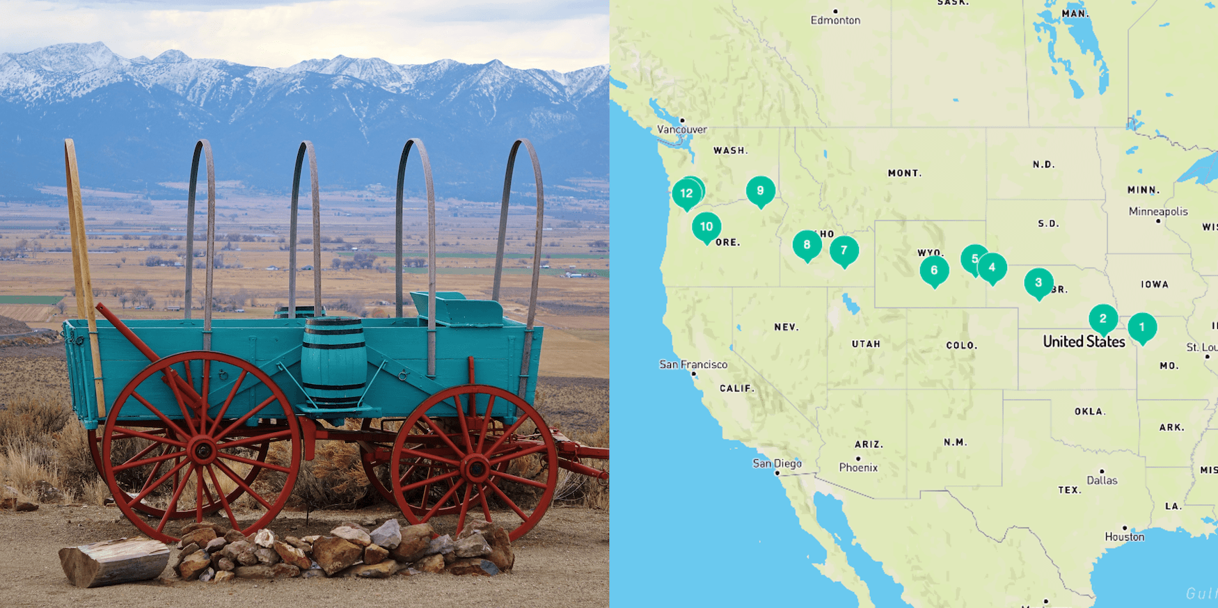
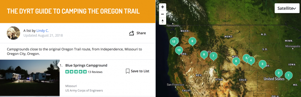
Your State by State Guide to Camping the Oregon Trail
It has been 175 years since the first hoards of hopeful travelers were embarking on a 2,000+ mile trip in search of land and opportunity. Today that historic route, known as the Oregon Trail, can still offer thrills (of the less life-threatening variety) for the curious road tripper. Especially if you’re looking for an adventure that will get you off of the main interstates and into some unexpected parts of the country.

History of the Oregon Trail
It all started when Thomas Jefferson made the Louisiana Purchase in 1803, which continued to fuel the expansion of the U.S. border further west. Though the purchase doubled the size of the continental U.S., little was known about what lay west of Missouri.
Jefferson sent Lewis and Clark on their famous expedition to explore this wild frontier between 1804 and 1806. As we know today, Lewis and Clark eventually made it all the way to the Pacific Ocean in Oregon and back. Their route was far too rough for large groups of settlers to follow, but the stories of the fertile, untamed land piqued the interest of fellow Americans.

“Oregon trail parkway in Scotts Bluff National Monuments, Nebraska,” according to photographer Krasnova Ekaterina
At the time, states farther west like Oregon were still territories of other European countries. Oregon technically belonged to Britain.
Robert Stuart , a fur trapper based out of Fort Astoria in Oregon, was the first man to traverse what we now know as the Oregon Trail. He traveled from Oregon to St. Louis, Missouri in 1810, and the journey took him 10 months. This established a much tamer route for emigrants who were eager to head west and settle along the frontier. By 1846 so many Americans were moving into Oregon country that the British government officially gave up the land to the U.S.
The Oregon Trail stretched more than 2,100 miles from east to west, starting in Independence, Missouri and ending in Oregon’s Willamette Valley. Typically, the journey took a group between five and six months. Many people followed the trail all the way to Oregon, while some chose to stop at other destinations along the way, or to move south into California or Utah.

“This historic site near Baker City, OR still has original ruts of the trail cut by pioneer wagons migrating to Oregon more than 150 years ago,” according to photographer Dan Lewis
The popularity of the Oregon Trail peaked in 1843 and would last for the rest of the century, making a lasting impact on the geography and demographic makeup of the United States.
Still today, a majority of the trail and land around it remains untouched with visible wagon ruts serving as the only reminder of its past. In 1978 the Oregon Trail was designated a National Historic Trail by congress. Though some of the land is now privately owned, what remains under government control is officially cared for by the National Parks Service with help from local organizations and government agencies.
State-by-state Guide to Camping the Oregon Trail
Because so much of the trail is surrounded by untouched wild land, the Oregon Trail is an ideal destination for outdoor lovers.
Today, portions of the trail follow some main interstates, but most of the original trail has to be followed on smaller highways and backroads through Missouri, Kansas, Nebraska, Wyoming, Idaho, and Oregon. Some of the land is privately owned, making it impossible to follow the entire trail exactly, but the National Park Service provides detailed driving directions to help travelers follow it as closely as possible. They also have an Oregon Trail app , where you can find routes, historical information, and self guided tours.

Courthouse and Jailhouse Rock monuments along the Oregon Trail
We’ve gone state-by-state and outlined the best campgrounds and Oregon Trail historic sites to get you started.
Missouri was the official jumping off point for emigrants eager to head west on the Oregon Trail. There were several cities where groups would congregate and gather supplies, but the most well-known starting point was Independence, Missouri. Groups would gather in early April or May and set out on the open prairie, hoping to beat the snow in the mountain passes that lay ahead. Because Independence is so close to the border, this is the shortest portion of the trail comprising only 16 miles.
Where to Camp in Missouri

Photo by The Dyrt camper Michael J.
Blue Springs Campground is located near Lake Jacomo, about 20 minutes outside of downtown Independence. You can spend time fishing and kayaking on the lakeor easily head into town to check out the historical sites. There are campsites with full hookups here, or you can opt for a primitive site. Either way, you will get to sleep near the lake and enjoy the serenity of the place.
“I like this place a lot. My wife and I just go down for the day sometimes to trial ride and let our dogs run. Still a great place to drop your boat in. You can even rent their boats for a decent price. Great fishing and swimming spots.” — The Dyrt camper Janelle M.
Oregon Trail Historic Sites in Missouri

Truman Courthouse, also known as the Jackson County Courthouse, in Independence, Missouri
While in town there are two main historic sites to check out: Independence Courthouse Square Complex and Minor Park/Redbridge Crossing. The Independence Courthouse Square Complex was the site where a lot of the action took place. This is where groups were gathering supplies and getting ready for the long journey west. There are still several historic buildings in the area, along with a lively downtown atmosphere to explore. Be sure to stop by the National Frontier Trails Museum for historic information about the trail.
Independence Spring, where wagon trains would make their first stop for water, can be seen near the museum. From there, you can take a wagon tour through downtown Independence.
Minor Park is another prominent point along the route. It’s located near the Missiouri, Kansas border. Cutting right down the middle of the 27-acre park is a deep swell. The swell was made by early wagon trains making their way west. This is where groups made their first water crossing over the Blue River.
Now that you are in Kansas, the Oregon Trail moves into more wild country where you can enjoy quiet campgrounds and pristine waterways. Those traveling the trail during its heyday, stopped here at Alcove Spring to rest. This is one of the most interesting destinations on the trail, with many written accounts of the place and names left forever embedded in rocks above the spring. The trail cuts upward through the northeast corner of the state. It is 165 miles total until you reach Nebraska.
Where to Camp in Kansas

Photo by The Dyrt camper Tara S.
Stop for the night at Fancy Creek State Park . This campground is conveniently located near the driving route, and features 200 primitive campsites and 24 sites are equipped with electric hookups. You can get in the water on your kayak, do some fishing, or check out the 6-mile mountain biking trail.
“Right on the Big Blue. Quaint. Vault toilets, no water. Trailhead to a nice trail. Some sites have shelters. It’s kind of a spread out layout. Great place to get away from busy.” – The Dyrt camper Tara S.
Oregon Trail Historic Sites in Kansas

Image from The Dyrt camper Tara S.
Approximately 6 miles south of Marysville, Kansas, you’ll find Alcove Spring . This was a popular spot for pioneers to camp, thanks to its close proximity to the water and the surrounding rock formations. You can still see the signatures of travelers who carved their names into the rock ledge above the spring. There are trails and interpretive markers throughout the area, including wagon swells you can follow to the main camping area used by early pioneers.
Members of the Donner-Reed party stayed at Alcove Spring as well. They lost one of their members here, and one of them even wrote a detailed description of the area in a journal entry.
Nebraska is home to several of the Oregon Trail’s most iconic landmarks, including Chimney Rock, Courthouse Rock, and Jail Rock. These geographical formations tower over the endless seas of prairie grass. They served as mile markers, encouraging the emigrants that they were making progress on their journey. Today you can hike around them, and even find the names of the trails former travelers carved into the rock. At approximately 424 miles, this stretch of the trail is much longer than the previous two, but its geographical wonders make it worth the distance.
Where to Camp in Nebraska

Photo by The Dyrt camper Glenn G.
On your first night in Nebraska, we recommend staying at Buffalo Bill Ranch State Rec Area. The campground is located along the North Platte River, where you can enjoy watching birds and fishing. The campground is also right next to the Buffalo Bill Ranch State Historical Park , where you can tour the home and barn of William F. Cody “Buffalo Bill” who was a prominent figure and entertainer in the Wild West.
“The sites were nicely secluded and the campground was quiet. We didn’t plan on doing much exploring in the area, but ended up spending the better part of our day here.” – The Dyrt camper Sara S.
For the second night, farther west in Nebraska, Riverside Campground near Scottsbluff is a great place to stay. The campground is an oasis along the river, complete with a bathhouse, complimentary WiFi, fishing ponds, and an arboretum.
“The three days we stayed there were a number of rvs with people from the Scottsbluff area. We were there during Gering days and had no issues getting a site. Gravel but with full hookups if needed.” – The Dyrt Camper Chris C.
You’ll find hiking at nearby Scottsbluff National Monument and Wildcat Hills , along with a variety of Oregon Trail historic sites.
Oregon Trail Historic Sites in Nebraska

Homestead National Monument of America in Beatrice, Nebraska
Fort Kearny was a military outpost established by the U.S. army in 1848. The fort was built to protect overland travelers. Pony express riders, scouts, and workers building the Transcontinental Railroad took refuge here as well. Today the area is a state park, where you can walk the trails and tour building replicas with artifacts from the original fort.
The Homestead National Monument of America commemorates the Homestead Act of 1862 , which played a significant role in westward expansion. Visitors can explore the surrounding hiking trails, take a cell phone guided audio tour, or look at exhibits in the heritage and education centers.
Pioneers had to cross the South Platte River to the North Platte River to continue on their way. The area was referred to as the Upper Crossing near California Hill . After crossing the river, they would then take on a steep grade, the first major one on the trail, up California Hill. Wagon ruts can still be seen here running up the length of the hill.
Courthouse Rock and Jail Rock stand side-by-side. These landmarks were familiar amongst fur trappers, who likely gave them their names long before the Oregon Trail was established. They continued to be a guiding marker on the long journey west, and were considered the first significant landmarks for travelers along the trail.

Chimney Rock in Nebraska
Scottsbluff National Monument is located near the town of Scottsbluff along the North Platte River. The area is full of hiking trails, and visitors can see the area where wagon trains moved through Mitchell Pass. In the onsite museum, visitors can also see a large collection of frontier inspired watercolors and photographs by William Henry Jackson.
Chimney Rock is easily the most famous landmark along the Oregon Trail, serving as an icon for westward expansion into the American West. The National Parks Service reviewed pioneer journals and concluded that Chimney Rock was by far the most mentioned destination along the trail. Located within half an hour of Scott’s Bluff National Monument and four miles south of Bayard, this landmark is a must-see for Oregon Trail enthusiasts. Onsite, you can learn more about the area and the history of the Oregon Trail experience.
Oregon Trail travelers came upon one of the most dangerous parts of the trail in Wyoming; the crossing point along the North Platte River. Travelers short of cash would skip the ferries crossing the treacherous waters, for their own, makeshift routes — which often ended tragically.
You’ll find some of the most distinct wagon ruts along the trail at the Guernsey Ruts. In Wyoming, some groups who left too late in the season also met their first troubles with winter snow. This includes the Willie and Martin Handcart Company who were taking the trail into Utah. They got caught in the snow at Martin’s Cove where many starved and died.
The Mormon church has designated a site for Martin’s Cove, though the true location where the group camped in 1856 is still debated. This stretch of the trail is also where you truly move into the western landscape with more hills and mountains springing up in the wake of the previously flat terrain.
The journey through Wyoming is 491 miles in total .
Where to Camp in Wyoming

Guernsey State Park Photo by The Dyrt Camper Daniel B.
On the first night, Guernsey State Park in Wyoming offers an ideal spot near the Guernsey Ruts. The campground is also located along the shores of Davis Bay, where you can swim and fish.
“There are options ranging from tents to yurts. It really is a diverse place. Lots of big rigs with big boats at this place. The sites range from no electricity (which made it a bit louder with generators going at night) to 50 amp. Little dusty in places. We stayed in Sandy Beach and had a great view of the water which was perfect at sunset.” – The Dyrt camper Scott M.
On the second night we recommend a stay at Rim Lake Campground just outside of Rawlins. The campground is close to the main road, making it easy to go to all of the surrounding historical sites.
“It’s a good place to fish, camp, and hang out.” – The Dyrt camper Andrea F.
Oregon Trail Historic Sites in Wyoming

Guernsey Ruts
The Guernsey Ruts are the most distinctive remaining wagon wheel ruts from the Oregon Trail that can still be seen today. The wagons crossed over soft sandstone here, which resulted in areas where the ruts dig down five feet into the ground. Because of the surrounding geography, it is assumed by historians that nearly every wagon that crossed the trail moved through this same exact spot, which is also the reason for the existing rut’s depth and lasting impact.
Fort Laramie National Historic Site was originally an established fur trading post. As western migration became more popular, the fort became a military post. Eventually it was abandoned in 1890. Fort Laramie is located just 52 miles from Scottsbluff National Monument in Nebraska.
Independence Rock , or as native tribes called it, painted rock, is considered the halfway point along the Oregon Trail. Pioneers considered it a good sign for the rest of the trip if they made it to the rock by mid summer. Independence Rock also came to be known as The Great Register of the Desert, because of all of the names and imagery that would be carved into it during the years the trail was used heavily.
The 510 miles of the Oregon Trail that winds its way through Idaho offers scenic vistas and riverside camping. Another major river crossing, at Three Islands Crossing, took place here. This was also a major fork in the trail, where travelers had to choose between two routes.
Many emigrants also settled in some of the small towns along the trail in this state, and buildings from that time period litter the landscape.
Take a taste of naturally carbonated spring water at Soda Springs and climb Big Hill, the steepest hill along the trail.
Where to Camp in Idaho

Massacre Rocks State Park photo by The Dyrt camper Dana Y .
Massacre Rocks State Park is a fully-equipped campground with an amphitheater, museum, hiking trails, fishing, tent sites, and cabins. The park got its name because of a deadly clash between settlers and natives in the area. You can see one of the Oregon Trail historic sites, Register Rock, nearby.
“We showed up during the week so it wasn’t too packed. Brought our fishing poles and although we didn’t catch anything, was well worth it. Be sure to go up to Register Rock up the road! So much history here. Highly recommend!” – The Dyrt camper Kali D.
On the second night in Idaho, Three Island Crossing State Park is another overnight option close to an Oregon Trail historic site. The area is rich with local wildlife, especially birds. Nearby there is a winery, where you can kick back and relax. An Oregon Trail History and Education Center can be visited onsite as well.
“Very nice, and well kept. Clean bathrooms and a lot of history with and Interpretive Center in the park.” – The Dyrt camper Anne V.
Oregon Trail Historic Sites in Idaho

Register Rock is located near Massacre Rocks State Park. This is another rock where pioneers famously carved their names into the stone. It is protected by a fence, but you can still get a glimpse of the historic signatures.
A steep climb was encountered at Big Hill in Idaho, followed immediately by the steepest descent along the trail. You can walk the hill to get a taste of what the experience would have been like, and nearby you can also visit the National Oregon/California Trail Center in Montpelier . The Montpelier interpretive center features artifacts and offers the chance to learn more about the individuals who chose to take on this long journey west.
A favorite resting point for many emigrants along the Oregon Trail was the Soda Springs Complex . The warm water from the springs allowed people to relax, bathe, wash clothing and even bake bread. For most this was the first opportunity to do this with ease along the entire 2100+ mile journey. Some of the water here comes out of the ground naturally carbonated. You can still drink from these springs and enjoy fizzy water of the Earth.

Three Island Crossing, Idaho
Historic Chesterfield, Idaho is an original pioneer settlement, where you can see what life would have been like after pioneers left the trail. Multiple buildings, including a general store, a Mormon meeting house, and several residential dwellings are still standing. Many of the buildings have been restored and are, during certain times of the year, open to walk through.
Three Island Crossing at Glenn’s Ferry was a difficult river crossing for Oregon Trail travelers in Idaho. This was a major fork in the trail, where they either had to cross the Snake River and head west on the northern route or keep going along the southern route.
The northern route was preferable as it took less time, while the southern route was less treacherous with no need to cross the river. This Oregon Trail guide follows the northern route. The southern route would have gone down through Vale and Central Oregon, rather than up through Ontario and along the Columbia River Gorge.
Congrats — you made it to Oregon without dying of dysentery or a rattlesnake bite! Luckily, following the trail these days is a much safer endeavor than it would have been nearly two hundred years ago.
Here, the landscape moves through Oregon’s eastern desert and then into the lush expanse of the Columbia River Gorge, and soon after that, the Willamette Valley. Along with stunning views, you can look forward to camping along rivers and under giant fir trees. It is hard not to feel a similar, albeit different, satisfaction upon completing this 524-mile stretch of the trail.
Where to Camp in Oregon

Hilgard Junction State Rec Area photo by The Dyrt camper Steven G.
For the first night in Oregon, check out Hilgard Junction State Recreation Area. This campground features 18 primitive campsites along the water. You will also find a shelter with an Oregon Trail interpretive center and a rafting access point along the Grande Ronde River.
“Although this park is near the highway, it makes for a great day visit or overnight camping. The river is very close and the Umatilla National Forest is a just a short drive up the river.” – The Dyrt camper Lindsey W.
On night two, you can stay at the Wyeth Campground in the Columbia River Gorge National Scenic Area. From the campground you can access the Gorge Trail. The area was the site of an early settlement , and was also used as a campsite for the Civilian Conservation Corps in the 1930s.

Wyeth Campground photo by The Dyrt camper Dory K.
There aren’t any tent camping sites near Oregon City, which is the official end point of the Oregon Trail. However, there is an RV only site at the Clackamette RV Park.
For tent camping, we recommend heading a little further into the heart of the Willamette Valley and staying at the Champoeg State Heritage Area . Many emigrants spread out through the valley once they reached Oregon, so this gives you a chance to see and explore more of the area. This site is also historically significant. It’s the site where Oregon’s first provincial government was formed in 1843, the year of the big Oregon Trail crossing boom known as the Great Emigration. Onsite there is a visitors center and a pioneer log cabin museum, offering glimpse into pioneer life at the end of the Oregon Trail.
“This campground is a wonderful escape for someone who is not wanting to travel too far from the urban areas like Salem-Keizer. It is a quiet campground with a designated Dog area, beautiful cabins, trails, and an interpretive museum.” – The Dyrt camper Kelly N.
Oregon Trail Historic Sites in Oregon

End of the Oregon Trail marker
Farewell Bend State Recreation Area is located just outside of Ontario on the border of Oregon and Idaho. This is where pioneers spent their last night near the Snake River, bidding it farewell before heading on the last leg of the journey into Oregon. There are also campsites here if you don’t feel like driving to Baker City for the night.
Hat Rock was another distinctive marker along the trail. It is one of the last visible icons mentioned by Lewis and Clark on their journey west. You can stop by Hat Rock State Park to check it out.
Flagstaff Hill just outside of Baker City Oregon features 7 miles of preserved trail ruts that you can walk along. There is also an onsite museum , the Oregon Trail Interpretive Center. This was considered one of the more difficult parts of the trail as it required a steep climb through shoulder high sagebrush.
The End of the Oregon Trail site in Oregon City is the last stop . There is a heritage garden, general store, and museum. Through the museum you can also sign up for guided tours of historic main street and heritage homes within the city.
You did it!
Save a List of Oregon Trail Campgrounds on The Dyrt
Are you ready to move through thousands of miles of less frequented, rare and beautiful landscapes? Walk (and drive) in the literal footsteps of history? Now you can earn the sense of accomplishment that awaits at the end of the trail by saving a list of Oregon Trail campgrounds on The Dyrt.
Before you know it, you will be ready for a celebratory cold brew — and lucky for you, Oregon is the perfect place for that.
Popular Articles:
- Get the Latest 2023 Camping Travel Trends
- How To Find Free Camping in National Forests
- The Checklist Every First Time RVer Needs
- Find Free Camping With The Dyrt Map Layers
- The Ulimate Boondocking Guide To Free Camping
- Everything You Need To Know About Wifi For Your RV
- 7 of The Best Overland Routes in North America
- 14 Wilderness Survival Tools You Should Have in The Backcountry
- Here's What To Add To Your Primitive Camping Checklist
Lindy Callahan
Lindy Callahan is a writer at The Dyrt. Utah is her home state, but she currently lives and explores in the Pacific Northwest. Her writing focuses on the way that the places we are drawn to shape our individual and collective identities. She is working on an MFA in nonfiction writing at Oregon State University. On the weekends you can usually find her hiking the coast range with her partner, Mike, and their dog, Phil Collins.
More Articles

We Just Fell in Love with Backcountry Weddings
Meet Donny Mays, a professional wedding photographer specializing in backcountry weddings. Hiking boots aren’t the footwear of choice for most brides and grooms. But wedding…
Fly Casting Prodigy + Hiker Struck by Falling Sheep | August 28 Outdoor News
Every week we’re rounding up camping and outdoor news, along with stories you might have missed from The Dyrt Magazine and around the web. This week,…

The Ultimate Oregon Trail Road Trip Itinerary

PureWow editors select every item that appears on this page, and the company may earn compensation through affiliate links within the story. All prices are accurate upon date of publish. You can learn more about the affiliate process here .

Road trips are a great opportunity to connect with your travel companion (besides listening to a killer playlist or gripping podcast series, it’s basically just tons of time for long convos), sightsee beautiful scenery and stop at some pretty cool places along the way. You’ve already done Route 66 and soaked in the coastal splendor of Highway 1, maybe even looped around the Road to Hana, but what about the Oregon Trail? Yes, the real-life route that more than 400,000 pioneers traveled from 1840 to 1880 and later inspired the classic computer game every ‘90s kid played. Following the 2,170-mile Pathway to the West that connects Independence, Missouri to Oregon City, Oregon , the Oregon Trail is one of the most interesting American road trips , full of history and fascinating pit stops, plus you can also spend the night in some great more modern destinations (because who doesn’t enjoy a little art, culture and cuisine between peeping preserved wagon ruts?)—and we’ve mapped it out. So all you have to do is fill your tank, buckle up and drive.
THE 16 BEST ROAD TRIPS IN THE USA TO TAKE IN 2021

1. Independence, Missouri
- Getting There: 20 minutes from Charles B. Wheeler Downtown Airport
- Where to Stay: Large Historic Remodeled Home , Modern Home in Woods , Woodstock Bed & Breakfast
Yes, Independence is the literal starting point of the Oregon Trail and for that, it’s the place the route—and your road trip—will inevitably kick-off, however, this Missouri city deserves more credit than just a historically significant dot on a map. It’s perhaps best known for the Truman Library & Museum, which has a permanent collection of information and relics about the Independence-born president. While the popular Frontier Trails Museum showcases pioneer-era relics and does wagon tours. Oh, and you’ll definitely want to chow down on some homemade American comfort food before hitting the road.
PITSTOP: Oregon Trail Nature Park (St. Mary's, Kansas)

2. Blue Rapids, Kansas
- Getting There: 2 hours 50 minutes from Independence, MO
- Where to Stay: Maryann’s Guest House
It would be easy to overlook Blue Rapids, located approximately 12 miles south of Marysville, but then you’d be missing out on the chance to witness Alcove Springs. A popular stop for weary travelers after crossing the Big Blue River, it boasts unique rock formations—many of which still showcase names carved centuries ago—a waterfall and, as the name would suggest, natural springs. Another claim to fame that’s not Oregon Trail-related though still interesting is that Blue Rapids holds the title of the smallest town in the United States to have hosted a national league baseball game.
PITSTOP: Rock Creek Station State Historical Park (Fairbury, Nebraska)

3. Ogallala, Nebraska
- Getting There: 5 hours 15 minutes from Blue Rapids, KS
- Where to Stay: Ogallala Family Home , Holiday Inn Express & Suites
Ogallala is a cool little city in Keith County with a population of 4,700 residents that you might recognize as a stop on the Pony Express and the transcontinental railroad. Consider spending the night in Ogallala, so you can wake up with fresh legs to hike California Hill just outside of nearby Brule. It was a particularly treacherous and essential part of the Oregon Trail journey. You can still see the deep ruts from wagon wheels even today. The panoramic views are pretty epic, too. Plus it’s a good excuse to get the blood flowing after all those hours in the car.
PITSTOP: Rock Creek Station (Fairbury, Nebraska)

4. Guernsey, Wyoming
- Getting There: 3 hours 12 minutes from Ogallala, NE
- Where to Stay: Camper , Bunkhouse Motel
A tiny town that’s big on historic and natural beauty, Guernsey showcases tons of Oregon Trail remnants. First up, head about three miles outside of town to Oregon Trail Ruts State Historic Site to see some of the best-preserved wagon marks anywhere. We’re never one to pass up an opportunity for some scenic hiking, especially after a lot of driving. Guernsey State Park is the perfect spot to stretch your legs and soak in the views of sandstone cliffs. If you’re keen on more outdoor recreation before getting back in the car, there’s boating, biking and fishing (it’s Wyoming, after all).
PITSTOP: Independence Rock (Casper, Wyoming)

5. Montpelier, Idaho
- Getting There: 6 hours 45 minutes from Guernsey, WY
- Where to Stay: Grandma’s House , Paris House , Country Cottage
Chances are Sun Valley and Sandpoint are higher up on your Idaho travel list than Montpelier but fans of Oregon Trail lore know about Big Hill, a fabled challenge that ranked as the longest, steepest climb on the entire route. And the descent was even more difficult. Needless to say, Big Hill is a big deal. Another old-timey attraction worth checking out? The Bank of Montpelier, which was established in 1891, was robbed by Butch Cassidy and his Wild Bunch Gang in August 1896. It’s the only financial institution the infamous outlaws hit that’s still standing.
PITSTOP: Fort Hall Replica (Pocatello, Idaho)

6. Boise, Idaho
- Getting There: 4 hours 45 minutes from Montpelier, ID
- Where to Stay: Newly Renovated Bungalow , Modern Farmhouse , Home2 Suites by Hilton
Boise is a lively city that will provide a fun change of pace in contrast to some of the smaller towns on your route thus far. The capital of Idaho has many exciting attractions such as the Boise Art Museum, where contemporary works adorn the walls of an Art Deco building and outdoor sculptures make their presence known in the garden. The Boise River Greenbelt, a series of trails and parks along the water, is another huge selling point and a lovely way to spend the afternoon. To up the ante on outdoor adventure, visit Boise National Forest.
PITSTOP: Philip Foster Farm National Historic Site On The Barlow Road/Oregon Trail (Eagle Creek, Oregon)

7. Oregon City, Oregon
- Getting There: 6 hours 45 minutes from Boise, ID
- Where to Stay: Stonehouse , Floating Bungalow , Happy Rock Inn
The official end to the Oregon Trail, Oregon City obviously deserves a visit for historical purposes but it’s also a great place with many modern charms, too. On the heritage side of things, costumed guides take visitors through interactive exhibits that better reveal what life was like in the mid-1800s at the End of the Oregon Trail Interpretive Center . Don’t miss the Museum of the Oregon Territory either. Oregon City is also home to one of the great American Main Streets. A walk along this revitalized thoroughfare reveals why. It’s lined with an enticing array of shops, cafes, restaurants and breweries.
PITSTOP: Willamette Falls (West Linn, Oregon)

8. Willamette Valley, Oregon
- Getting There: 50 minutes from Oregon City, OR
- Where to Stay: Atticus Hotel , Downtown Cottage , Half-Pint Farmhouse
Many settlers continued past Oregon City to Willamette Valley—and you should, too. Sure, it’s a region rather than a singular stop, however, it’d be pretty incomplete for us to spotlight a cute place like McMinnville without mentioning Carlton, just a few minutes down the road. Surrounding the quaint towns are sprawling vineyards that grow some of the best Pinot noir in the country. It’s pretty fortuitous that Willamette Valley caps off the trip because you’re not going to be driving anywhere after wine tasting.
7 GENIUS GROUP TRAVEL HACKS FOR YOUR NEXT ROAD TRIP

Freelance PureWow Editor
- Skip to global NPS navigation
- Skip to this park navigation
- Skip to the main content
- Skip to this park information section
- Skip to the footer section
Exiting nps.gov
Alerts in effect, westward migration.
Imagine yourself an emigrant headed for Oregon: would promises of lush farmlands and a new beginning lure you to leave home and walk for weeks? More than 2,000 miles of trail ruts and traces can still be seen along the Oregon National Historic Trail in six states and serve as reminders of the sacrifices, struggles, and triumphs of early American settlers. Read More
Do you want to experience the trail? Learn more about where you can go, historic sites you can visit and more!
Take a look at interactive, historic, and trip planning maps to learn more about locations along the trail.
Many folks wonder what a national historic trail actually is. Hear from trail staff about how we define these important parts of history.
Connect on social media, explore deeper on mobile apps, watch videos, and check out other digital media!
Check out current news, events, special projects, new research, and more!
Last updated: July 18, 2023
Park footer
Contact info, mailing address:.
National Trails Office - Regions 6, 7, 8 Oregon National Historic Trail 1100 Old Santa Fe Trail Santa Fe, NM 87505
Stay Connected
Explore subjects and stories related to this park.
- Beyond Oregon
- Central Oregon
- Columbia River Gorge
- Eastern Oregon
- Oregon Coast
- Southern Oregon
- Western Oregon
- Willamette Valley
- Forest Bathing
- Mountain Biking
- Photography
- Ski/Snowboard
- Storm Watching
- Vacation rental near Mt Bachelor Oregon
- Vacation Rentals
- Bend Vacation Homes
- Sunriver Vacation Homes
- Oregon Wine
- Restaurants

In-N-Out Burger to Open in Beaverton, Less Than 15 Minutes From…

Stay A Night In An Authentic Railroad Caboose In Oregon, With…

Eugene voted best in Oregon and named among best places to…

NASA Quietly Training Robot Dog on Mt. Hood to Navigate Landscape…

A Remote Pizza Joint In Oregon, Ike’s Makes Some Tasty Pies…

It’s Impossible Not To Love This Breathtaking Wild Flower Trail In…

Woman Unearths 20-Million-Year-Old Marine Mammal Fossil on Oregon Coast

The Tallest Ice Cream Cones In Oregon Can Be Found At…

Sleep Overnight in a Luxury Yurt That’s on Your Own Private…

Your Stay at This Magical Oregon Bed & Breakfast Will Feel…

Escape to Serenity: A Secluded Cabin Getaway on the Southern Oregon…

This Classic Oregon Drive-In Transports You Back to the Good Old…

This Charming Pizzeria in the Mt. Hood Corridor Has Been Loved…

The 50s Style Diner In Oregon That Will Have You Dancing…
- Entertainment
- Things To Do
The Most Awesomely Epic Oregon Trail Road Trip You’ll Ever Take
From Vale, Oregon to The Dalles, we give you a breakdown of all the Oregon Trail sites you'll want to visit for a historical road trip through history.

Do you love Oregon history? Maybe you want to take the kids on an interactive and educational experience. I'm already thinking of fun spring break activities for our family, and learning about early pioneer history may just be the perfect bonding experience. This Oregon Trail road trip will send you back in time on an epic journey (and you won't even have to die from dysentery).

If you're scratching your head at the dysentery reference, it comes from the Oregon Trail game I played as a kid . In it, you traveled by wagon from Independence, Missouri to The Dalles, Oregon just as 80,000 people did in the 1840s. The number of pioneers is actually around 200,000, but many settlers on the Oregon Trail chose to make their homes elsewhere, like Utah and California. For this road trip, we'll focus on the Oregon leg of the trail from near the Idaho border to The Dalles, Oregon.
Expect to spend anywhere from four days to a week of travel time for this road trip. It really depends on how much or how little you want to see, and that's the brilliant part of this journey. What would have taken over a month to pioneers we can now plug away at our own pace. You will experience parts of the historic trail, walk in the ruts of pioneer wagon trains, and explore carefully curated museums.
We highly recommend that you take this road trip anywhere from late spring to early fall for the best odds that locations will be open and the weather will be accomodating.
Your epic adventure begins at:
Keeney pass interpretive site, vale, oregon.

After a rather harrowing time crossing the Snake River from Old Fort Boise in modern-day Idaho, pioneers found themselves setting foot for the first time on what would come to be the state of Oregon. Some travelers actually chose a more southerly route that bypassed the Snake River crossing altogether, but both trails rejoined each other at the juncture of Keeney Pass .
The site offers a 2/3-mile round-trip hike along a section of the original Oregon Trail and visible wagon ruts near an interpretive shelter. Wayside exhibits tell the stories of the overland experience and the native peoples of the area.
From Keeney Pass, head north on Lytle Blvd to Vale, Oregon. Take a moment to view the Stone House Museum , then take US-26 West and continue several miles north to take a right on 5th Avenue East. Go left on Hill Rd./Old Oregon Trail. The first site you'll arrive at is:
Alkalai Springs and Tub Springs Interpretive Site

The springs laden with Alkali were a major hazard for the Emigrant's livestock which often died if they drank too much of it. Humans as well fell victim to the bad water. Tub Springs, on the other hand, was a critically important water source on this leg of the journey.

Continue north on Hill Rd./Old Oregon Trail to:
Birch Creek Interpretive Site

According to the Bureau of Land Management, Birch Creek provided much relief to emigrants after the hot, dusty, and parched segment of the Oregon Trail from Alkali Springs. In the early years of the Oregon Trail, there was plenty of grass for livestock and fresh water for animals and people. Emigrants often held over at this location for one of two reasons: some were sick from drinking the stagnant water at Alkali Springs, while others rested for the long haul up the Burnt River Canyon - the roughest part of the trail to come.
The site contains a 300-foot gravel trail that leads to interpretive panels. The trail is not barrier-free. The actual Birch Creek crossing and emigrant camp is located on private land and is not accessible to the public.
The road to the site can be rough, particularly going uphill.
Go north on Lockett Rd. and cross over I-84 onto Old Hwy. 30. to:
Farewell Bend State Recreation Area, Snake River, Ontario, Oregon

Pioneers named it "Farewell Bend" as they would be saying goodbye to the Snake River before turning their wagons northwest and overland. Today's Farewell Bend finds a lovely State Recreation Area with camping facilities (April 15 - Oct. 31), fishing, sand volleyball and basketball courts, as well as picnic areas. Settlers would have spent a few days here, resting and watering their livestock.

From Farewell Bend, the choice is yours to follow the more historically accurate Hwy. 30, or the faster I-84 W.
While Interstate 84 follows the basic route of the old Oregon Trail, Hwy. 30 is the more accurate route to follow in the footsteps and wagon ruts of the early pioneers.

From I-84, take Exit 302 to US-86 toward Richland/Hells Canyon. Follow signs to:
National Historic Oregon Trail Interpretive Center, Baker City, Oregon
The Interpretive Center offers much to do, from the museum to a replica of a pioneer gold mine, and the opportunity to walk in the real Oregon Trail wagon ruts at Flagstaff Hill.

After exploring the museum, try the 2.4 mile out-and-back Panoramic and Stamp Mill Trail . You'll end up on an overlook with views of the Powder River. Wildflowers start blooming in the spring, and you may catch a glimpse of local wildlife like Marmots and Prarie Dogs.

According to the National Park Service, the Oregon Trail reached Flagstaff Hill by going through the small valley, known as Virtue Flat, that lies just south of the interpretive center. Traveling through this valley was no easy task. Emigrants had to fight their way through shoulder-tall sagebrush just after spending four or five difficult days ascending Burnt River. The trek across Virtue Flats created 13 miles of still visible Oregon Trail ruts. Approximately one mile of these ruts lies on the interpretive center's grounds. The ruts can be reached by following hiking trails from the interpretive center or by driving a half-mile west of the center's entrance on Highway 86 to a turnout.

Head back to Baker City and hop on I-84 W. Travel through La Grande and continue west on I-84 for 10.5 miles to Exit 248. Turn onto the Spring Creek Road/Kamela then right on Old Emigrant Hill Scenic Frontage Road (Highway 30). Take the first right, follow signs and go 2.4 miles to Park on Forest Road 1843. You'll be at:
Oregon Trail Interpretive Park at Blue Mountain Crossing

The Interpretive park is only open during the summer months , so if you're wanting to add this stop to your road trip, please plan accordingly.
Here you'll find some of the best-preserved evidence of Oregon Trail travel, from "wagon scars" on the trees to depressions made in the ground by livestock and prairie schooners. This area was a pioneer rest stop on what was a harrowing journey into the Blue Mountains. Choose a discovery trail and walk in the footsteps of Oregon Trail emigrants.
Retrace your driving route back to I-84 W. Again, here you can choose to take the more historical Old Highway 30, or the faster Interstate route. Your next destination is several miles up at:
Emigrant Springs State Heritage Area

Just as the pioneers did, you've now summited the Blue Mountains and it's all downhill from here.

Wagon trains would have camped in the vicinity for several days and replenished their water barrels from the spring. Today you'll find camping areas, cabins, and yurts for rent year-round . Bring your horse for camping and trail rides, or learn about the adventures of early settlers from the park’s Oregon Trail interpretive shelter and covered wagon display.
Continue 7 miles on I-84 W or the Old Emigrant Road (Hwy. 30) to the Deadman's Pass Rest Area.
Deadman Pass, Pendleton, Oregon

Oregon Trail emigrants typically reached Deadman Pass, then known as Crawford Hill, after three days travel over what Edward Evans Parrish, emigrant of 1844, called "the worst road yet." The name, "Deadman’s Pass", was actually the result of an accident during the Bannock War when a teamster driving a wagon through the pass was killed.
The wagon ruts can be found near the rest area, and the viewpoint is a bit further down I-84/Hwy. 30.
From Deadman Pass, continue down the hill into Pendleton and follow signs for the Wildhorse Resort and Casino.
Tamástslikt Cultural Institute, Pendleton, Oregon

This beautiful museum explores the history of the Oregon Trail from the perspective of the Native American tribes who owned this land for thousands of years. Audio, artistry and historic images, rare and beautiful artifacts create a broad sensory experience depicting the Tribal world. The Institute is an incredibly immersive experience.

From their website: "Come to Tamástslikt Cultural Institute and experience the storied past, rich present, and bright future of our tribes through interactive exhibits, special events, and informative programs. More than just a museum, Tamástslikt celebrates the traditions of Cayuse, Umatilla, and Walla Walla Tribes. With dramatic exhibits, renowned artwork, and interesting — and yes, fun — events year-round, Tamástslikt Cultural Institute offers a 10,000-year journey in a single afternoon."
Backtrack to I-84 Westbound. Here, Old Hwy. 30 merges with the Interstate for this portion of the journey. Take I-84 W to exit 207 and follow signs toward Reith, Oregon. Keep on Reith Road, following the Umatilla River to:
Corral Springs Oregon Trail Site

The Corral Springs site is on private land owned by the Ramos family. The family has given permission for public access to the 1.4 miles of two parallel sets of Oregon Trail ruts that descend into the canyon. Approaching the site you will see No Trespassing signs, but a closer look reveals the land graciously allowed by the owners. Please be respectful.
Continue west on Reith Road to reach the town of Echo, Oregon. Make a right on S Thielsen St, drive three blocks, and take a left on Oregon Trail Rd.
Fort Henrietta Park / Umatilla River Lower Crossing, Echo, Oregon

The National Park Service has listed Fort Henrietta as a National Historic Trail Site because it was a campsite and river crossing for Oregon Trail emigrants. The river ford known, as the Lower Crossing (Pendleton was the site of the Upper Crossing), was located at the south end of the park.
The park includes several historic displays including a covered wagon museum and antique fire equipment museum. The museums are unmanned with push-button recorders that provide information to visitors. The first Umatilla County jail is in the park as is a replica blockhouse. Interpretive panels provided by the National Park Service and storyboards with information on Echo history are also located in the park.
Continue southwest on Oregon Trail Rd. and follow Oregon Trail Site signs to take a right on a gravel road.
Echo Meadows

Echo Meadows is a 320-acre site managed by the Bureau of Land Management. Walk the site's half-mile (one way) paved path to visit the remaining one-mile-long stretch of swales. If you walk the wagon ruts, stop at the property line; do not trespass onto the adjacent farm. A pavilion near the parking lot contains interpretive exhibits that tell the stories of the trail and the area's native people.
BLM.gov: When travelers along the Oregon Trail began using a more direct route to The Dalles from the Umatilla Crossing, Echo Meadows became a rest stop to prepare for the windy, hot, and dusty trek to Butter Creek and Wells Spring. Some chose to camp here based on the availability of feed for livestock. Some remarked the grass was “hip-high to a horseman.”

The sandy sagebrush-covered interpretive site is a fair representation of what emigrants encountered in late spring and early fall after crossing the Umatilla River. The interpretive site is a stark reminder of what the Columbia River plain was like before water was pumped from the ground. A trace of the trail is barely discernible in nearby farm fields where thousands of wagons compacted the soil.
From Echo Meadows, return to Oregon Trail Road and take a right. Make a left on US-207, Lexington/Echo Highway. There are many backroads that will lead you to the Wells Spring site. If you're feeling adventurous, Google Maps will take you there. For a more reliable route, follow US-207 to Lexington, then make a right on US-74, Heppner Highway to Ione, Oregon. Make a right on Ella Road, and continue north to veer right on Ione-Boardman Road. Several miles up you will make a left turn onto Immigrant Lane and follow the signs to Wells Spring.
Wells Springs, Boardman, Oregon

The Wells Spring segment of the Oregon Trail is an extremely isolated section that traverses what was the Boardman Bombing Range during WWII. This location includes a pioneer cemetery, stage station, and rusted wagon remains. The public access point is available to everyone, however, to hike the 7-mile segment within the old bombing range you must obtain permission from the Naval Weapons Station by calling 541-481-2565.

The road to reach this site is long and graveled, so plan accordingly with water, snacks, and a reliable vehicle.
From Wells Spring, head west on Immigrant Lane and follow it as it bends around to the hamlet of Cecil, Oregon . Pioneers crossed Willow Creek near here. In Cecil, make a right onto Heppner Highway, then a quick left onto Cecil Lane. Take another quick left onto Cecil Road/Fairview Lane and follow it a few miles to make a right on Fourmile Canyon Road. Follow the signs to:
Fourmile Canyon Historic Site

This segment of the Oregon Trail was part of the difficult transit of the Columbia Plateau. Interpretive panels explain the site’s deep rut scars and the emigrants’ ascent out of the canyon. North is the modern city of Arlington on the Columbia River, but historically it was named Alkalai after the canyon that runs south of it.
Pioneers could choose to continue overland to the Fourmile Canyon site, but others chose to pack up their wagons at Arlington and head down the Columbia to The Dalles. Settlers would raft down the river in Hudson's Bay Company boats or Native American canoes.
While you can take McDonald's Ferry Road from the Fourmile Canyon site, the next area can only be accessed from the west bank of the John Day River. Two travel options are:
1. To closely experience the Oregon Trail route, follow Fourmile Canyon Road north to make a left and follow US-19 John Day Highway south to Cedar Springs Lane where you will turn right. Keep on Cedar Springs Lane for several miles to the locale of Rock Creek where you'll make another right on Lower Rock Creek Lane. Keep heading east to take a right on McDonald Ferry Road. This turns into Klondike-John Day Road. At the point where the road first meets the river is where McDonald Crossing was. Continuing north along the river will lead to the primitive Hoag Road and an eventual left on Heritage Lane, then Quinton Canyon Road to I-84.

2. For a more reliable paved (mostly) highway drive, follow Fourmile Canyon Road north to make a right on US-19 John Day Highway. Follow signs to Arlington and onto I-84 Westbound. Take Exit 104 to US-97 Bend/Yakima and keep left to US-97 South/Sherman Highway. After several miles, take the exit to US-206/Wasco. Stay on US-206 through the town of Wasco, then make a left on Klondike Road. Keep on the gravel Klondike Rd. as it turns into McDonald Ferry Lane and follow it all the way to the John Day River.
McDonald Ford / McDonald's Crossing

Where Klondike Road changes from east-west straightaway to meandering gravel road you will be driving on the actual Oregon Trail all the way to the river.
Today this area of Sherman and Gilliam Counties is encompassed by windfarms. In the 1850s, this was a shallow ford on the John Day where it was safe to make the river crossing. Here you'll find an interpretive monument and gorgeous views of the wild and scenic John Day River.

Retrace your path back down Klondike Road to Wasco, and US-97 to Biggs Junction where you left I-84. This time you'll be taking a left on Biggs-Rufus Highway just before the freeway interchange.
Biggs Junction to The Deschutes River
If you love interesting and less well-known places to hike you're in for a treat here. As you travel this last part of the overland Oregon Trail journey you'll be overlooking the Columbia River as pioneers did 175 years ago. It's a bit tricky to find the trail as it's not well marked, but check the Google Map below for the location you're looking for. There will be two Oregon Trail markers on the left and an inclining path between them. This goes up to Biggs Arch, a stunning natural rock formation with incredible views of the Gorge. There are wagon ruts along the path, so be on the lookout.

From Biggs Arch, continue west on Biggs Rufus Highway, which becomes US-206.
Heritage Landing / Deschutes River State Park
At this point, you're almost at your journey's end. The mouth of the Deschutes River is where pioneers made the crossing to the last leg of the trip that would bring them to The Dalles and the fertile Willamette Valley beyond.

Travelers frequently camped at the mouth of this large tributary of the Columbia River before crossing. In order to cross, some emigrant parties used the rocky islands near the river's mouth as stepping stones, while wagons were floated across and stock animals swam. Others forded the river using rafts.

Pioneer Joel Palmer wrote on September 28, 1845:
" The river is about one hundred yards wide, and the current very rapid; the stream is enclosed by lofty cliffs of basaltic rock. Four hundred yards from the Columbia is a rapid or cascade. Within the distance of thirty yards, its descent is from fifteen to twenty feet. The current of this stream was so rapid and violent, and withal of such depth, as to require us to ferry it. Some of the companies behind us, however, drove over at its mouth by crossing on a bar. "
Today you can camp, hike, and fish at the Deschutes River State Recreation Area .
Keep going on US-206/Celilo-Wasco Highway until it merges with I-84 W. Continue to The Dalles and take Exit 82 toward Columbia Gorge Discovery Center/Wasco County Museum.
Columbia Gorge Discovery Center and Wasco County Historical Museum

Not only will visitors experience Wasco County and Oregon Trail history here, but the Discovery Center has so much more to offer. From exhibits on the ancient origins of the Columbia River Gorge to Native American history and raptor shows. If you love history you'll really enjoy a visit.

Follow the Columbia Gorge Discovery Center on Facebook to keep in touch with all of their goings-on.
From the SE corner of the Columbia Gorge Discovery Center parking lot, you may hike the paved Riverfront Trail to the last destination on our list, or drive there if you like.
By car, take US-30 south to the River Road Exit and make a left. Park between River Road and River Trail Way, and take the trail toward the Columbia River.
Crates Point
And now Pioneers, you have reached the end of your journey. Where Chenowith Creek meets the Columbia River you will be standing at the very last point of the true overland Oregon Trail. From 1843-1845, this was the only way to Oregon City and beyond.

From OCTA-trails.org : At Crates Point, a protected harbor at the mouth of Chenowith Creek, the Oregon Trail pioneers put into the river. John McLoughlin, despite orders from his superiors, sent bateaux and food here to assist (and occasionally rescue) weary emigrants. Nearby were many pine trees to cut for building immense rafts that could hold up to six wagons. Writing in 1843, explorer John C. Fremont described them as “ark-like rafts, on which they had embarked their families and households, with their large wagons and other furniture, while their stock were driven along the shore.”
After 1843, many emigrants chose to take the newly-explored Barlow Road Trail which avoided the extremely dangerous Columbia River journey. We will cover a Barlow Road Trip in a future article.
Have you taken a similar road trip or visited some of the sites along the old Oregon Trail? Let us know if we've missed anything.
Related articles more from author, stay a night in an authentic railroad caboose in oregon, with stunning valley views, eugene voted best in oregon and named among best places to live in u.s., it’s impossible not to love this breathtaking wild flower trail in oregon.

Oregon Coast Aquarium Recognized by Newsweek Among Best in the U.S.

Spring into Creativity: Newport’s Free Art in April Show Returns for 2024

Wolverine Spotted In Eugene – May Be Same Animal Recently Spotted On Coast
- Shipping & Returns
Last Updated on April 1, 2023 by Danielle Denham
October 23rd, 2023 • 9 min
Road Trip Along the Oregon Trail: A Journey Through History

Back in the 19 th century, the Oregon Trail took American settlers across the country with the promise of greener pastures and new opportunities. The road wasn’t easy. Pioneers traveled across what is now seven different states, subjected to exposure, disease and exhaustion. But the trail is a little different today. On your journey, you’ll find wild and wonderful Oregon Trail museums, natural landmarks, as well as wagon ruts from the original route. Follow our guide and discover when the Oregon Trail was first in action, how long it took and which sites to see with the ultimate Oregon Trail road trip itinerary.
Everything you need to know about the oregon trail, where is the oregon trail.
The Oregon Trail started in Independence, Missouri and ended in Oregon City, Oregon, with an outpost in Vancouver, Washington. The trail was in regular use from the 1840s to the 1870s, until the railroad became a more popular option.
From the Midwest to the Oregon coast, you can follow the trail through:
How many miles is the Oregon Trail?
The Oregon Trail was a wagon route stretching 2,170 miles. The total journey took up to six months using modified wagons pulled by mules or oxen. The terrain was incredibly bumpy, so many pioneers often walked on foot.
Can you drive the Oregon Trail today?
Yes, you can drive along the Oregon Trail today – or at least as close as the roads can get you. Following the Oregon National Historic Trail from Independence, Missouri to Oregon City, the trip is approximately 2,500 miles by car. Without stopping, that’s around 33 hours.
There are plenty of city breaks and rest stops along the way, so the trip can be as long as you make it. You’ll see fascinating attractions and landmarks used by the pioneers to mark their progress.
Fortunately for us, there’s no need for makeshift wagons towed by oxen anymore. Pick up an affordable ride and settle into the great American landscape with Thrifty.
Historic Truman Courthouse
112 West Lexington Avenue, Independence, MO 64050
Nearest Thrifty car rental location: Tsh Overland Park TLE
Embark on your cross-country adventure at the Historic Truman Courthouse , the industrial birthplace of the Oregon Trail in Independence, Missouri. Outfitting wagons for the long journey ahead, hundreds of thousands of early pioneers emigrated west from this very spot. If it was a good enough start for them, it’s good enough for us, right?
Look out for stone plaques outside the building marking the beginning of this historic trail. It’s a great photo opportunity before you head west.
Topeka, KS 66612
Nearest Thrifty car rental location : Tsh Overland Park TLE
Drive across the Missouri border and into the Sunflower State of Kansas with a pit stop in Topeka. Perched on the Kansas River, Topeka is a vibrant city with a powerful history.
Visit the palatial Kansas State Capitol Visitor Center, Gage Park and the Brown v. Board of Education National Historical Park. Take an educational tour and learn more about the pivotal Brown v. Board of Education lawsuit which declared racial segregation in public schools unconstitutional in 1954.
Oregon Trail Park at Scott Springs
KS-99, Westmoreland, KS 66549
Drive alongside the Oregon National Historic Trail as you head northwest, surrounded by wide-open fields. The Oregon Trail Park at Scott Springs commemorates one of the old emigrant camping grounds on the long, arduous route.
Find informational signs depicting the history of the Oregon Trail, picnic shelters, and restrooms. There’s even a mile-long accessible walking trail if you need to stretch your legs. Be sure to say hello to the wagon and oxen sculpture made by a local resident.
Alcove Spring
East River Road, Blue Rapids, KS 66411
Nearest Thrifty car rental location: Omaha - Eppley Airfield
Alcove Spring is a scenic historical marker between Blue Rapids and Marysville. It’s an important landmark of the Oregon Trail in Kansas, as the park was once another favorite campsite for traveling emigrants.
The distance between the Oregon Trail Park and Alcove Spring is only 45 minutes by car. But imagine walking 40 miles on foot, hauling a rickety wagon and all your earthly belongings.
Alcove Spring is known for its picturesque streams and trails. The springs are also dotted with 19th-century pioneer engravings and wagon swales which are still visible to this very day.
Local hotels are less than 15 minutes’ drive away in Maryville, making it a good spot to stop off and recharge for the night.
The World’s Largest Covered Porch Swing
510 Jefferson Avenue, Hebron, NE 68370
Nearest Thrifty car rental location: Hastings Municipal Airport
Celebrate crossing the state lines of Nebraska with a quick visit to the world’s largest covered porch swing in Hebron. The 32-foot-long swing can squeeze up to 18 adults and 24 children, so there’s plenty of room for the whole family.
And why not stop for coffee or lunch in Hebron while you’re there? The Blue Bison is a local gem that serves up freshly baked goods, salads and sandwiches in a modern, friendly atmosphere.
Stuhr Museum
By now, you’ll have seen glimpses of the natural landscape where the Oregon Trail pioneers found respite. Next, let Grand Island’s living history museum take you back in time to the 19th-century railroad towns and prairie living. The 208-acre Stuhr Museum is open all-year round with more than 100 interactive buildings to explore.
Fort Kearny State Historical Park
1020 V Rd, Kearney, NE 68847, United States
Nearest Thrifty car rental location: Kearney Regional Airport
Fort Kearny was the first Western military outpost built for Oregon Trail emigrants, merchants and gold prospectors on their travels along the Platte River. Visitors can admire pioneer artefacts and exhibits on the fort’s significance to the cross-country trail.
Fort Kearny is also just a 15-minute drive from the Great Platte River Road Archway Monument . This unique landmark and exhibit is another great family-friendly stop to learn more about the Western migration.
Why not check in at the Fairfield Inn & Suites in Kearney before the next leg of your trip?
Buffalo Bill Ranch
2921 Scouts Rest Ranch Road, North Platte, NE 69101
Nearest Thrifty car rental location: North Platte Regional Airport
From Fort Kearny, take the I-80 West running parallel to the trail for around 160 miles. But along the way, don’t miss the chance to visit the Buffalo Bill Ranch in North Platte.
Visit the former home of the infamous soldier, bison hunter and showman. His ranch is now a 16-acre park complete with preserved 19 th -century memorabilia. The mansion was built in 1886 during the height of the ‘Buffalo Bill’s Wild West’ show’s popularity.
You can take a self-guided tour between late spring and early fall, with plenty of hotels nearby to stay the night.
Chimney Rock
Chimney Rock Trail, Bayard, NE 69334
Chimney Rock was a significant landmark for pioneers traveling the Oregon Trail, making it one of the most famous markers of the American West. Standing 480 feet above the North Platte River Valley, the rock was visible for miles. It featured in many emigrant diaries, becoming a sign of hope and progress.
Fort Laramie National Historic Site
965 Grey Rocks Road, Fort Laramie, WY 82212
Nearest Thrifty car rental location: Scottsbluff Airport
Once you’ve officially crossed into Wyoming from Chimney Rock, it’s a 90-minute drive to Fort Laramie National Historic Site .
Fort Laramie was the largest outpost in the Northern Plains between 1834 and 1890, seeing tens of thousands of emigrants heading for Oregon, California and the Salt Lake Valley. It played the role of a fur trading post and later a military garrison as conflicts grew between the Indigenous Americans and the Army.
National Historic Trails Interpretive Center
1501 North Poplar Street, Casper, WY 82601
Casper, Wyoming is beautiful city at the foot of the mountains – home to the National Historic Trails Interpretive Center . The Oregon Trail led straight through to Fort Casper , which has its own museum you can visit today.
The wildly engaging Interpretive Center will teach you all about the migrants who walked the trail to greener pastures in Oregon or sought gold in California.
We recommend staying in Casper overnight to explore a little more. You’ll only be 25 minutes from Bessemer Bend National Historic Site, where travelers crossed the North Platte River for the final time.
Independence Rock State Historic Site
WY-220, Alcova, WY 82620
Spare a few hours to take in the magnitude of Independence Rock , one of the most important historic sites on the Oregon Trail west of Fort Laramie.
Independence Rock is treasured for its many carvings, names and messages left by pioneers, and Indigenous Americans before them. Visitors can use the public trail around the rock or hike the rock itself.
Can’t get enough of iconic rocks? Head to Split Rock Pullout only 30 minutes away, another landmark that helped travelers navigate on the road to Oregon. It’s also a great opportunity to divert north to Yellowstone National Park if you have extra days to spare.
Idaho Falls
Idaho Falls, ID 83402
Nearest Thrifty car rental location: Jackson Hole Airport
The next leg of the journey is a six-hour drive to Idaho across the plains. So, we recommend a pit stop in picturesque Idaho Falls to welcome the Gem State.
There’s plenty to see and do in the city, and you’ll also be just an hour from Massacre Rocks State Park where you’ll meet the Oregon Trail again. Reserve a room at the Residence Inn Idaho Falls for direct access to the city’s Japanese Friendship Garden.
Three Island Crossing State Park
1083 South Three Island Park Drive, Glenns Ferry, ID 83623
Nearest Thrifty car rental location: Mountain Home, ID TLE
Three Island Crossing was one of the most difficult river crossings in Idaho, hopping over the Snake River once again. Visitors can still find original wagon ruts in and around the crossing from the original Oregon Trail.
The park offers plenty of green space and picnic areas too, so you can stretch your legs after the long drive. Plus, you can make the most of free admission to the park’s interpretive center.
Boise, ID 83702
Nearest Thrifty car rental location: Boise Airport, Idaho
It’s just over an hour’s drive from Three Island Crossing State Park to Boise, the capital of Idaho. Set in front of the Boise Mountains, it’s a great place for another urban stayover amid the wild and unruly West.
Explore Boise’s lively downtown area, boasting more than 100 different restaurants, or enjoy some fresh air along the lush, tree-lined Boise River Greenbelt .
Tamastslikt Cultural Institute
47106 Wildhorse Boulevard, Pendleton, OR 97801
Finally crossing the state line into Oregon, the historic trail will take you north to Pendleton.
The must-see Tamastslikt Cultural Institute is the only museum on the Oregon Trail dedicated to celebrating Indigenous American culture. Discover the story of American migration from an Indigenous perspective, tracing 10,000 years of tribal history and community.
Admire handcrafted art, artefacts and belongings from the Cayuse, Umatilla and Walla Walla tribes.
Columbia River Gorge National Scenic Area
Hood River, OR 97031
Nearest Thrifty car rental location: Portland International Airport
Hugging the Washington state line, follow the Oregon Trail along I-84 for around 120 miles, or two hours. You’ll soon find yourself swept up in the magic of the awe-inspiring Columbia River Gorge National Scenic Area .
Grab your hiking boots and discover waterfalls and breathtaking vistas. Or simply kick back with a relaxing retreat at the Columbia Gorge Hotel and Spa, offering panoramic views, massages and more.
End of the Oregon Trail Interpretative Center
1726 Washington Street, Oregon City, OR 97045
Nearest Thrifty car rental location: Tsh Portland TLE
Thank goodness for modern cars. After approximately 2,500 miles from Missouri to Oregon, mark the end of your Oregon Trail road trip at the aptly named End of the Oregon River Trail Interpretative Center .
Recap the long and deadly pioneer journey at the exhibits and snap a photo in front of the Oregon Trail map. Yep, you really made it that far. Time to celebrate downtown.
Follow the footsteps of American pioneers along the historic Oregon Trail. It may not take six months anymore, but it’s sure to be the trip of a lifetime. Explore capital cities, Oregon Trail museums and rural roads from the Midwest all the way to the Oregon coast with Thrifty.
Ready for your Oregon Trail road trip?
You’ll find your nearest Thrifty car rental location in Overland Park, just a 35-minute drive from Independence, MO.
Check Tsh Overland Park TLE car rental deals.
Looking for more travel inspiration?
Discover more must-see road trips and destination guides on the Thrifty blog .
- Goonies Filming Locations
- Guide to Weird Stuff in Seattle
- Coast to Coast I-10 Road Trip
Looking to book your next car rental?
Related articles, boston to seattle: must-see stops on an i-90 road trip.
Stretching from Boston to Seattle, Interstate-90 (I-90) is a great choice for a coast-to-coast road trip. Covering over 3,000 miles and 13 major states, there’s plenty to see and do. From beautiful landscapes to iconic cities and national parks, get ready for the ultimate adventure.
Discover American Civil War history in Gettysburg, Pennsylvania
Gettysburg Pennsylvania is famed for its role in the Civil War. Filled with historical sites, it’s the perfect place for a road trip. Plan yours today.
I-80: Best Road Trip from Chicago to Cleveland
Buckle up and get ready for an adventure on your road trip from Cleveland to Chicago. Discover the best stops, diners and attractions with Thrifty.
Oregon Trail

- 1 Understand
- 4.1 Independence, Missouri
- 4.2 Across Nebraska
- 4.3 Chimney Rock & Fort Laramie
- 4.4.1 Wrong trail. Lose 3-4 days.
- 4.5 Snake River Crossing
- 4.6 The Dalles
- 4.7 Oregon!
- 6 Stay safe
- 7.1 See also
The Oregon Trail is a 2,200 mi (3,500 km) National Historic Trail across the United States , traditionally beginning in Independence , Missouri and crossing the states of Nebraska , Wyoming , and Idaho before ending near the Pacific coast in Oregon City , Oregon .
An estimated 400,000 settlers used the Oregon Trail or other Emigrant Trail branches to migrate west between the early 1830s and the completion of the Transcontinental Railroad in 1869. Today, the memory of the Oregon Trail lives on in books, cinema, and tales of the Old West . Countless more have undertaken the journey – at least vicariously – through one of the earliest (and greatest) educational computer games, The Oregon Trail .
The Oregon National Historic Trail is today's recreation of the trail, maintained by the National Park Service.
Understand [ edit ]

The Louisiana Purchase and the Lewis and Clark Expedition opened the Northwest for white settlement, and marked the beginning of the Wild West era. The "mountain men" and fur traders who traveled upstream in the early 19th century were few. The first known mountain passes were barely adequate for a horse and rider.
As better routes were found, wagon trails gradually were built westward, laying the groundwork for the Great Migration of 1843 . Nearly a thousand settlers crossed the Rocky Mountains in that single year. The Organic Act of the Oregon Territory (1843) granted 640 acres (a square mile, 2.56 km²) of free homestead land per couple in the vast Oregon Territory, which covered what is now Washington state , Oregon , Idaho and parts of Wyoming and Montana . The weakened position of southern states during the American Civil War (1861–1865) gave U.S. federal authorities free rein to promote homesteading and westward expansion. Unimproved homestead land was often free or available for as little as $1.25/acre.
The Emigrant Trail flooded with Oregon-bound homesteaders (1843–1854), who were soon followed by Mormon pioneers (1846–1847) and California gold rush prospectors (1849) heading west. Travelling by wagon, an average group of migrants could complete the Oregon Trail in about six months.

Weather was a major concern; as some mountain passes and river crossings went from treacherous to impossible in winter , expeditions departed in early spring to give time for safe arrival. Hundreds of settlers travelled together as large wagon trains, keeping mutual assistance available in time of need. Migrants traded with other travellers when supplies ran low, abandoning items on the trail when wagons became too heavy for animals to pull. An ox-drawn cart at two miles an hour would need to crawl ten hours a day for more than a hundred days to cover the 2,200-mile trail – and obstacles and delays routinely increased that time. Horses were faster but more expensive, and needed to be fed, while an ox could graze like a cow. Mules had their own stubborn characteristics.
The people and animals often needed to stop for food and water, resting if they were injured or had fallen ill. At night, groups circled the wagons with the livestock in the middle to prevent animals from being stolen or wandering away. On arrival, a successful party could claim contiguous 320-acre parcels for each adult in an entire extended family. Arriving early meant a better chance of claiming prime locations with control over river valleys with water for irrigation.
From 1843–1869, four hundred thousand brave pioneers had heeded the call to "go west, young man", making the arduous trip on trails and infrastructure which had seen few gradual improvements. Some split from the path to colonize Utah or join the California gold rush and some safely reached Oregon's Willamette Valley . Quite a few did not survive the long and arduous journey.
And then, almost overnight, it was over. On May 10, 1869 the Last Spike was driven in tiny Corinne , Utah, thereby joining the Union and Central Pacific railroads; a journey that had taken half a year was abruptly reduced to one week. Where travel by wagon might have cost $200 per person, the train fare was $60 and that with a roof over everybody's heads. It wasn't much of a choice. Before long, the Oregon Trail was a relic of a bygone age, of hardy adventurers and America's first age of westward migration. In movie serials and cheap westerns, the Oregon Trail became a scene for danger and derring-do, full of sinister forces determined to prey upon innocent settlers and tragedy around every bend.

However, the story of the Oregon Trail had a surprising turn ahead. In 1971, a student teacher and amateur programmer named Don Rawitsch created a text-based computer game for his eighth grade history class called The Oregon Trail . On-line gameplay was BASIC and primitive, relying on expensive terminals linked to a distant time-sharing system. As the frontiers of desktop computing advanced, subsequent Oregon Trail versions added graphics, more choices for players to make, and dire consequences for their mistakes.
On The Oregon Trail , students had to name their characters and then subject their creations to mortal peril, from starvation to disease and injuries of every kind. Unlike any other educational game, characters could die ; as holding no funeral for a deceased traveller would cause morale of the party to decline, the game allowed players to erect gravestones (usually with profane epitaphs) for subsequent players to find. Players had to choose whether to interact with natives , buy or beg for aid, examine landmarks like Chimney Rock – and, in later versions, hunt for food in a mini-game whose environmentalist message could almost be heard over the howls of bloodthirsty kids. Befuddled teachers found themselves mediating fights between students over whether capsizing a wagon in the Snake River was accidental or a deliberate attempt to lose unwanted members of the party, and who wrote what about whom on a tombstone by the Blue Mountains .
Ported to the Apple ][ in 1979, the Macintosh and IBM PC in 1990, and to game consoles and smartphones in 2011, the game was actually quite good at teaching the history of the Oregon Trail. And, above all else, it was fun .
This itinerary is designed to cover major sights from the real Oregon Trail and the computer game alike. While a full checklist of every wagon rut and historical marker would take months, the goal of this journey is simply to see the vastness of the land, as the original settlers would have experienced it long before steam power and rail travel slashed the duration of a trip around the world from the original three years to a mere eighty days .
Prepare [ edit ]

In the pioneer era, this lengthy journey required careful planning. A farmer often already owned wagons and oxen, but many supplies needed to be purchased and unnecessary items kept off the wagons to keep weight down. Dried, salted or tinned foodstuffs were chosen as they could be preserved for long periods of time. Firearms and ammunition allowed hunting to stretch limited food stocks, if the traveller was skilled in their use. Supplies and skills to repair damaged wagons or treat injured voyagers were essential; opportunities to acquire needed items en route were few and prices became progressively worse as the pioneer ventured further into the hinterland.
Today, the trail can be spread out over a week without much difficulty.
It's a good trip for summer, between June and August. Too early or too late in the year may find some roads impassable due to snow, particularly in Wyoming, and some sights are closed between November and March. Summer will be hot but manageable as long as you carry sunscreen (and your wagon has air conditioning). There will be some long days on the road, so it would be wise to choose a comfortable vehicle and agree upon a code of conduct among the members of your travel party.
You can stock up on provisions at the start of the trail in Independence or Kansas City. While prices have risen since Matt's General Store was selling foodstuffs at $0.20/lb in the game, there are many places to eat meals and buy snacks each day along the trail. With prices and selection largely consistent along the route, there is no need to load hundreds of pounds of supplies into wagons at the trailhead.
Trail-side accommodations of all sorts are available. Major hotel chains can be found off the interstates, while there are motels with local charm (for better or worse) in smaller towns on state routes. There are plenty of campgrounds , which may be closer to the conditions in which early pioneers slept when circling the wagons for the night. Reservations may be necessary during the height of summer in national parks .
The U.S. National Park Service is a good source of information on the Oregon National Historic Trail ; their site includes downloadable maps, brochures and state-by-state Auto Tour Route interpretive guides which may be invaluable when trying to follow the historic trail using multiple modern roads and highways.
Get in [ edit ]
The journey begins in Independence (Missouri) , which is directly southeast of Kansas City , Missouri .
Kansas City has been a rail transport hub since 1865, having seen a dozen railways come and go over the years. Amtrak 's Missouri River Runner reaches KCMO from St. Louis today, with onward connections to Chicago . Well served by highways, Kansas City ( MCI IATA ) is also the nearest major airport ; several rental car firms operate from the Kansas City airport, downtown Kansas City or Independence.
Go [ edit ]
Independence, missouri [ edit ].
Day 1 Distance: 20 mi (32 km) Pace: Steady

The National Frontier Trails Museum in 39.08 -94.43 1 Independence is the perfect place to get into an Oregon Trail state of mind:
- 39.0868 -94.4195 1 National Frontier Trails Museum , 318 W. Pacific, Independence , ☏ +1 816 325-7575 , fax : +1 816 325-7579 . M-Sa 9AM-4:30PM, Su 12:30-4:30PM, open year-round . Dedicated to several pioneer trails and America's westward migration as a whole, beginning with Lewis & Clark and the early fur trappers, but some fun exhibits challenge you to prepare as a pioneer would. Be sure to gather your travel party for a run at the test wagon. It's surrounded by shelves of weighted sacks of supplies like bullets, beans, and biscuits for you to choose; an alarm goes off if you overload the wagon. This is a great opportunity to argue about who would last how long on the trail without bacon or coffee and really stir up some emotions at the outset. Tales of woe from the trail, artifacts that were abandoned by actual emigrants, and heated debates over the relative merits of mules vs. oxen. $6, $5/seniors, $3/kids .
As the birthplace of U.S. President Harry Truman, Independence boasts a few memorials to its favorite son; as he was born 20 years after the heyday of the Oregon Trail, it's best to try to ignore them.
The 39.0935 -94.4154 2 1859 Jail and Marshal's Home is period appropriate, in case you'd like to get further into the mindset. It's open April to October.
Having stocked up on supplies, make it an early night, because tomorrow the journey begins in earnest.
Across Nebraska [ edit ]
Day 2 Distance: 555 mi (893 km) Pace: Strenuous
This is a lot of driving for one day, but you might as well cover a lot of ground while spirits are high and the members of your party are still getting along. (The day could be split in half around Kearney if you prefer, but there aren't many trail-related sights in eastern Nebraska, so it will be a flat start to your trip.)
Starting from Independence , take I-435 N to I-29 N toward 41.27 -96.03 2 Omaha . Carry on to 40.83 -96.7 3 Lincoln , where you'll pick up I-80 W. Either Omaha or Lincoln will make a good stop for lunch. This should get you to Fort Kearny in 40.7 -99.085 4 Kearney , Nebraska with enough time to poke around:
Once you're west of 41.146 -100.761 5 North Platte , you can begin looking for somewhere to spend the night. If you'd like to get off the Interstate, pick up Route 26 just west of 41.125 -101.718 6 Ogallala . The landscape changes very quickly from acres of corn to rolling hills and gorges, lone trees, and distant rock formations. There's an Oregon Trail Trading Post in 41.326 -102.129 7 Lewellen , which is good for fuel, supplies, and taxidermy, and there are some motels as you head northwest, the best of which are in the town of 41.67 -103.1 8 Bridgeport (which also has a decent spread of restaurants and cafés).
Chimney Rock & Fort Laramie [ edit ]
Day 3 Distance: 220 mi (350 km) Pace: Steady
Get an early start, because this will be a great day. West on Route 26 (which becomes Highway 92) is one of the best sights of the trail.

You have reached Chimney Rock . Would you like to look around?
Down the road is a small 41.699 -103.3406 4 historic cemetery that is also worth a stop. Out front is a sign about the rigors of the trail and those who died along the way. There are gravestones erected in the last few years for ancestors who are buried in the vicinity of the cemetery, and older gravestones for people who died some 20-30 years after the end of the trail.
Back on Route 26/Highway 92, head northwest until you reach the town of 41.88 -103.66 9 Scottsbluff . Nearby is the 41.836 -103.708 5 Scotts Bluff National Monument , another important landmark on the trail. Stick with Route 26 when it splits from Highway 92 on the other side of Scottsbluff and head northwest. Like the original emigrants, you are following the Platte River, and will soon cross the state border into Wyoming.

The next major stop is 42.213 -104.518 10 Fort Laramie , with a national historic site near the town of the same name. Turn left from Route 26 to Highway 160 and the fort will be 3 mi (4.8 km) down the road.
As you continue west, you'll begin to see signs excitedly advertising the presence of "wagon ruts." These are tracks that were worn into stone by the wheels of countless wagons and remain intact today. The best known are the 42.257 -104.749 7 Guernsey Ruts , three miles south of the town of 42.2698 -104.7415 11 Guernsey (which is about 13 mi (21 km) west of Fort Laramie). They're certainly worth a look to soak up some of the atmosphere the settlers would have experienced. The site is open year-round. Look for the gloriously overheated prose of the Works Progress Administration historic sign nearby.
Route 26 will end at I-25. Head north to 42.855 -106.297 12 Casper , which is a good place to stop for the night. 42.836306 -106.370799 8 Fort Caspar Museum is a reconstructed 1865 fort at a major crossroads of several trails heading West. The Fort buildings are open April to October, while the museum of both Fort and regional history is open year round.
Independence Rock [ edit ]
Day 4 Distance: 350 mi (560 km) Pace: Strenuous
Wyoming has done a particularly nice job commemorating the state's ties to the Oregon Trail. There are plenty of historical markers along the way, ranging from little white marble blocks saying 'Oregon Trail' to big, grandiose signs from the 1930s and school lectures from the 1980s. But this is also the state where following the original route takes you furthest afield, so have your navigation and supplies in order before you set out.
From Casper, head southwest on Highway 220 for about 55 mi (89 km), and look for signs for a rest area – with smaller signs referring to a historic site nearby.

You have reached Independence Rock . Would you like to look around?
This is another of the trail's most iconic sights:
Another trail waypoint, 42.449 -107.21 10 Devil's Gate , is ahead on Highway 220. The "gate" is a gap in a mountain ridge, carved by a river long ago, which opens to a pretty scenic vista.
Highway 220 ends shortly afterward at Highway 287, near the town of 42.352 -107.457 13 Muddy Gap . You can take Highway 287 south to join I-80 W, but an interesting detour lies nearby. (Check your fuel before you commit, because there will be no service stations for a while.) Take 287 northwest past the near-ghost town of Jeffrey City and Sweetwater Station to Highway 28, which you can take southwest. On a hillside is another near-ghost town called 42.497 -108.731 14 Atlantic City , which has some eccentric art and an occasionally open café, and an actual ghost town , 42.468 -108.802 15 South Pass City . Visitors are welcome to wander around this atmospheric mining town, which has several surviving buildings in various states of preservation. The site is overseen by a passionate group of volunteers who will be glad to share information about the history of the area. There's also a surprisingly large souvenir shop. While it can get really hot here, the scenery alone is worth the detour.
Highway 28 meanders south to meet Route 191 at a crossroads in the small town of 42.109 -109.448 16 Farson (which has a gas station). Turn left (south) to meet I-80 W at 41.587 -109.203 17 Rock Springs , where you can find a place to sleep for the night, or...
Wrong trail. Lose 3-4 days. [ edit ]

At this point, the members of your travelling party could probably use some time outside of the car. If hiking or overnight camping sounds appealing, then take a break from the trail and enjoy two of America's most spectacular national parks: 43.78 -110.68 1 Grand Teton National Park and 44.42 -110.57 2 Yellowstone National Park .
Leave I-80 W at Rock Springs to take Route 191 north; or, if you took the South Pass City detour, follow Highway 28 west until the crossroads in Farson, and then turn right to go north on Route 191. The road will join Route 189 and lead directly into 43.48 -110.762 3 Jackson Hole , a tourist town that serves as gateway to the Tetons. (This route winds uphill through the mountains, and while an average driver will be fine in more or less any vehicle, it may be tough for inexperienced drivers, particularly at night, and should not be attempted during winter weather without precaution and experience, assuming the road is even open.)
Continuing north, you'll find Yellowstone, and accommodations should be easy to find in surrounding towns such as 44.645 -111.104 4 West Yellowstone .
Hunting was one of the most popular parts of the computer game, offering an out for players who failed to buy enough food in Independence or at one of the forts along the way. Hence, the opportunity to see Yellowstone's majestic herds – and possibly even bears, from a very safe distance – is practically a must for fans of the game. (Bison top sirloin is on the menu at a few of Yellowstone's restaurants, for anyone who would like to extend the verisimilitude.)
When you're ready to rejoin the trail, take Route 287 north from West Yellowstone, then I-90 W for a short distance to I-15 S.
Snake River Crossing [ edit ]
Day 5 Distance: 290 mi (470 km) Pace: Strenuous
If you are rejoining the trail via I-15 S, you could make one further stop at 43.205 -113.5 11 Craters of the Moon National Monument , which is well worth the visit off Route 26 (which joins with Routes 20 & 93). A northern spur of the Oregon Trail ran through the Craters of the Moon area; in search of a safe alternative to travel through Shoshone and Bannock Indian lands, a mountain man named Tim Goodale led a party of 1,095 people in 338 wagons through the bumpy lava flows in this area, and soon 43.301 -115.315 18 Goodale's Cutoff overtook the original section of the trail in popularity.
Routes 20/26/93 will diverge, but all three will join I-84 W eventually, and then you're back on the main trail heading west.

If you didn't detour at all, take I-80 W from Rock Springs toward the state border. Fort Bridger, another trading post, is next to the interstate near a tiny hamlet of the same name:
At this point the Oregon Trail turns north from Fort Bridger, while the Mormon Trail continues 100 miles westward to the Salt Lake Valley .
Retracing the original trail gets a little complicated here. Take Highway 189 north to Route 30, then travel west on Route 30; when it branches, follow the route north toward 42.085 -110.948 19 Cokeville instead of over the border into Utah. Route 30 will continue into Idaho through 42.3224 -111.2974 20 Montpelier and 42.655 -111.604 21 Soda Springs . Continue on Route 30 until it merges with I-15 N in 42.66 -112.2 22 McCammon , then stick with Route 30 through 42.87 -112.45 23 Pocatello to meet up with I-86 W, which will eventually become I-84 W.
This section of the trail follows the Snake River through a long, hot stretch of Idaho. Unlike the original settlers, you will not need to make any special effort to cross the Snake River. Unfortunately, few sights of note remain. You'll pass by the city of 43.02 -112.635 24 Fort Hall , which was named for another trading post; the actual fort and its namesake successor are long gone, though, leaving just a replica at Pocatello.
About 10 mi (16 km) west of 42.785 -112.854 25 American Falls , 42.681 -112.984 2 Massacre Rocks State Park shows why voyagers wanted to avoid the Shoshone and Bannock tribes. Ten emigrants were killed here in 1862, just east of the park. Today, the park offers campgrounds, access to the Snake River, and some wagon ruts. Look for 42.6524 -113.0167 13 Register Rock , a boulder where travellers carved their initials. (It's now protected by a shelter and fence.) The park is open year-round.
The Snake River and Raft River split 15 mi (24 km) further southwest; California -bound prospectors part ways here to head southwest to Nevada .
For those continuing to Oregon, the 43.618 -116.216 26 Boise area makes a good place to stop for the night. The 43.5423 -116.11 3 Oregon Trail Reserve (E Lake Forest Dr & Idaho Rte 21) includes a mile of the original trail for hiking and sightseeing on 77 acres of city parkland, at a point where wagons crossed the Boise River.
The Dalles [ edit ]
Day 6 Distance: 338 mi (544 km) Pace: Steady

Crossing the border into Oregon (and pausing for a brief celebration), take I-84 W toward 44.78 -117.83 27 Baker City . You'll soon have your first sight of the Blue Mountains, which travellers knew meant the end of the journey was near; they usually reached this point by late August or September.
As a side trip, the Hells Canyon Scenic Byway ends at Baker City; if you're doing well on time and the weather is favourable, it is well worth a look to soak up more of the scenery.
When you're ready to move on, continue west on I-84, which meets and follows the famous Columbia River from 45.84 -119.7 28 Boardman onward. The Columbia drains into the Pacific Ocean near Astoria ; it was the primary inland route for European traders and settlers, and today is popular for both windsurfers and hydroelectric dams. (Hard to say which an Oregon-bound expedition would have found stranger.)
45.6 -121.14 29 The Dalles is a good place to make camp for the night. There are a couple hotels away from town, near the river, which should add to the excitement. Tomorrow...
Oregon! [ edit ]
Day 7 Distance: 93 mi (150 km) Pace: Steady
It is strongly recommended that you become insufferable in your period-appropriate speech and behavior, and if you have been saving a good Oregon Trail game t-shirt, now is the time to don it. Because the Willamette Valley is at hand.
An emigrant party would have faced a difficult decision at The Dalles . There was no trail beyond this point, due to 45.3735 -121.696 32 Mount Hood . Pioneers had to convert their wagons to rafts and float down the Columbia River, which carried considerable danger, or shell out a whopping $5 or more to travel the eighty-mile Barlow Toll Road. This mountain road was steep and winding, with wagons pulled on ropes along grades of up to 60% at some points.
Today, you may keep your wagon dry and avoid the Barlow Road by driving west along the south shore of the Columbia River on I-84 (US30) through the 45.723 -121.572 4 Columbia River Gorge National Scenic Area – a good place for hiking and natural scenery.
With civilization soon surrounding you, I-84 W will join I-205 S.
Take exit 9 into 45.36 -122.61 33 Oregon City where Abernethy Green, George and Anna Abernethy's 640-acre homestead along the Willamette River, formerly represented the end of the Oregon Trail. This encampment and adjacent properties would fill rapidly with wagon loads of poor and exhausted pioneers seeking shelter from their first Oregon winter. Once here, they could resupply in Oregon City, scout possible homestead locations and file claims at the General Land Office. The original site was destroyed by flooding in 1861; by then, travel time along the Oregon Trail had been nearly halved and emigrants no longer needed to winter over. A visitor center now stands in its place:
- 45.365 -122.595 15 End of the Oregon Trail Interpretive & Visitor Information Center , 1726 Washington St, Oregon City ( at Abernethy Road ), ☏ +1 503 657-9336 . M-Sa 9:30AM-5PM, Su 10:30AM-5PM . As close to an official "end" as there is. The steps outside list many of the landmarks that you've passed along the way, giving a great sense of culmination to the journey. Regrettably, the museum is a bit of a dud, lacking the verve of its eastern counterparts. A souvenir shop sells commemorative patches for those proud few who have completed the trail and there's a sign out front that makes a good photo-op.
Congratulations! Award points for every member of your party who survived the trip and any provisions that you have left, including a working vehicle; triple points if you began as a farmer from Illinois . Alas, land claims are no longer free, but the beauty of the Willamette Valley is yours to enjoy.
Respect [ edit ]
This journey crosses native land .
The history of The Oregon Trail tends to be told through the eyes of early settlers on the wagon trains, an individualistic viewpoint focused on whether the voyager successfully reached the end of the trail. American cinema portrayed the Old West as a place of armed conflict between "cowboys and Indians", but these conflicts were rare in the early days. Between 1840-1860, fewer than 400 people on each side had been killed by conflict between colonists and natives while thousands annually died of disease, infighting, accident and misfortune.
The natives were trading partners and their assistance often invaluable.
Native relations soured when imported measles, smallpox, typhus and dysentery started causing the death of entire villages. Buffalo, once plentiful, declined in number and were disappearing from entire regions.
The Massacre Rocks incident of August 9th, 1862 killed ten settlers. In the retaliatory January 1863 42.1462 -111.914 16 Bear River Massacre , Col. Patrick Conner (stationed in Salt Lake City) and his California Volunteers marched north to the Bear River to kill 250 to 400 Shoshoni natives.
The educational video game is careful to label raids “riders attack” since they often came from “white bandits” and not Native Americans, but even its approach oversimplifies a complex history. The game includes no native playable characters and no explanation, from an indigenous perspective, of the impact on native communities as hundreds of thousands of migrants carved wagon roads, polluted water supplies along the trail and decimated wildlife through overhunting.
There is one lone native history museum on the trail:
Stay safe [ edit ]
You have dysentery.

Do you want to ford the river or caulk the wagon and float across?
- Carry a spare tire and watch your fuel gauge. There are some long stretches between fuel stations.
- Mobile phone reception is not guaranteed all the way through Nebraska, Wyoming, and Idaho.
- A good road atlas should suffice for navigation. GPS is valuable if you veer off the route, Donner Party-style.
- All but a few hundred miles of the original trails have been paved over by two-lane roads; some of the original U.S. Highway System, in turn, has been paved over or replaced by Interstate freeways. Non-motorized vehicles may need to take alternate routes at some busy points.
- Take care when wandering through the sagebrush that you don't disturb any critters , such as snakes .
Go next [ edit ]

- Portland is a half hour from Oregon City; enjoy some time outside of the car with some good food, drink & live music.
- Champoeg, 6.6 mi (10.6 km) SE of Newberg on the Willamette River, was the original location of the provisional government that launched the 1843 land rush. The village was destroyed by a December 1861 flood, the site is now a state park.
- Some travelers ended their journey in Astoria on the coast, a good place to relax.
- Heading south, the lovely Crater Lake National Park is about 3½ hours away.
- If you're inclined to embrace urban environs, continue north on I-5 N to Seattle (3 hours) and Vancouver (5½ hours).
- If you're planning to head back east by car and still have some time to spare, it might be worth taking a northern route on I-90 E through Washington , Idaho, Montana , and South Dakota , all of which offer some interesting sights along the way.
See also [ edit ]
- Lewis and Clark Trail
- Trail Of Tears National Historic Trail
- Pony Express National Historic Trail
- Ruta del Tránsito in Nicaragua was an alternative (along with Panama ) for those with deeper pockets or on the government dime
- Previous Featured travel topics
- Has custom banner
- Has mapframe
- Has map markers
- Guide itineraries
- Guide articles
- North America itineraries
- Itineraries
- Pages with maps
Navigation menu
IMAGES
VIDEO