Cookie banner
We use cookies and other tracking technologies to improve your browsing experience on our site, show personalized content and targeted ads, analyze site traffic, and understand where our audiences come from. To learn more or opt-out, read our Cookie Policy . Please also read our Privacy Notice and Terms of Use , which became effective December 20, 2019.
By choosing I Accept , you consent to our use of cookies and other tracking technologies.

Site search
- Los Angeles
- San Francisco
- Archive.curbed.com
- For Sale in Boston
- For Rent in Boston
- Curbed Comparisons
- Neighborhoods
- Development News
- Construction News
- Real Estate Market Reports
- Architecture
Filed under:
- Boston Transportation
Boston-area mass transit apps: 5 for helping navigate the T
These handy websites as well as applications through Google and Apple are best for navigating a system that can be full of delays
/cdn.vox-cdn.com/uploads/chorus_image/image/64041712/GettyImages_514660336.0.jpg)
Navigating the Boston area’s buses, subways, trolleys, and commuter trains can be tricky. And, given the system’s chronic delays ( and the odd derailment ), it can be a real headache too. These five transit apps and websites—all available through a wifi connection on smartphones or through apps downloadable from Apple or Google—can help ease the pain.
Trip Planner . This is pretty much the Massachusetts Bay Transportation Authority’s official portal for navigating the T and commuter rail.
It allows users to plan trips hours, even days, in advance; and users can search for wheelchair accessibility and trips with the fewest transfers or the least amount of walking (“Best route” is the default search function). It can also warn of track work or other realities that might delay trips.
Track the T . Software engineer David Newton started this free website after relying on the 73 bus to get back and forth from his private-sector job in Cambridge. Buses would “bunch up three or four behind each other with the timetable mostly fictional,” he said over email. He seized on the MBTA’s 2009 decision to make its real-time bus information public, and developed this app.
It tracks subway, trolley, and bus arrivals to the real-time second. It is especially helpful for riders if they’re at a stop along multiple routes going in the same direction. Newton’s Track the T will tell them when the next bus or train is coming that’s going their way—even if it’s not the one they intended to take. It’s a lifesaver when time is tight.
Aira . In early May 2019, the MBTA announced a six-month test of this app, which aids low-vision and blind people in navigating the T. Aira uses smartphone cameras to guide users in real time through public spaces such as train and bus stations, according to the Boston Globe . Available through Google and Apple, Aira is free for the six-month trial, but monthly plans generally start at $24.
Transit App . The MBTA officially endorsed this free app back in 2016 . It basically mimics the agency’s own Trip Planner site via tapping into the MBTA’s real-time data for arrivals and departures.
Transit App will also list departure times for nearby transit, in case other modes are going toward the same place; and the app includes ride-hail and bike-share options too. Finally, if riders are worried about missing a stop, they can set up Transit App to ping them when the stop’s coming up. Bonus: Transit App works for dozens of other cities and regions.
ProximiT . This free app that Jeff Lopes developed is available only through Apple. It lists arrival and departure times of buses, subways, and trolleys in order of how close they are to a rider’s location and desired time of departure.
Basically, ProximiT is another way to draw real-time information for commutes. In that, it bills itself as a kind of personal assistant for commuters.
Next Up In Boston Transportation
- Boston traffic and transit post-pandemic: Just imagine
- What should federal infrastructure money go to in Boston?
- 10 Boston stories that have nothing to do with coronavirus
- T changes due to coronavirus: What to know
- Hyde Park pitch highlights housing potential around transit
- Boston’s terrible traffic is a side effect of its housing market
Share this story
One-Day Itinerary
Day Trips From Boston
Sam Adams Brewery Tours
Top Things to Do
Free Things to Do
Things to Do With Kids
Skiing Near Boston
Beaches Near Boston
Hikes Near Boston
Boston Public Garden
Museums in Boston
Fenway Park Guide
Shopping in Boston
The Best Time to Visit Boston
Weather & Climate
Neighborhoods to Know
Driving in Boston
Public Transportation in Boston
Getting Around Boston: MBTA "T" Subway System
Navigating the MBTA "T" Subway System and More
:max_bytes(150000):strip_icc():format(webp)/Untitleddesign7-5ae6f8808023b9003661e615.jpg "the mbta trip planner")
Elijah-Lovkoff/Getty Images
One of the most daunting parts of visiting Boston for the first time is figuring out how to navigate the city’s public transportation: the Massachusetts Bay Transit Authority’s (MBTA) subway and bus system, commonly known as the “T.” However, once you get a lay of the land and try it out a few times, you’ll likely find that it’s an easier — and more affordable — way to get around. Parking can be hard to come by, so you’ll be happy not having a car if you plan on staying in the city.
How to Ride Boston’s T (Subway and Busses)
The T is the United States’ oldest subway system, which started running back in 1897. It’s not particularly nice, but it will conveniently get you from one point to another within the city so you can see even more than you could by foot (though Boston is a walkable city). It also comes in handy during winter months when walking isn’t enjoyable.
- Fares : A single ride CharlieTicket for the bus is $2 and the subway is $2.75. However, you’ll save on each ride if you load money onto a CharlieCard (for example, save 50 cents per ride on the train). Do some research and determine if it make sense to purchase a 7-day unlimited pass, which you can use on both the trains and busses. There are also monthly passes available if you’re in town for an extended stay. Children under 11 who are with an adult ride for free, along with military personnel, police officers, firefighters and government officials. Reduced fares are available to students and seniors.
- Types of Passes: There are two types of passes and the best option for you depends on how often you’ll be riding the T, along with the modes of public transportation you want to take. First is the CharlieCard, which is ideal for those that plan on taking the bus and/or train frequently and will give you discounted one-way fares. Oftentimes a CharlieTicket is best for visitors, as they can be bought at any train station and loaded with cash or passes as you need them. While you won’t get discounts this way, they’re also valid on the Commuter Rail and Ferry and will allow you to ensure you aren’t spending more than you need on public transportation.
- Hours of Operation: Hours will vary depending on the line and station you plan on traveling on, but for the most part, you’ll find that the T runs from 5 a.m. to somewhere between midnight and 1 a.m. Don’t wait until it’s getting close to 1 a.m. to head to the train or bus though — that’s recipe for missing the last one from your station. Boston bars typically stay open until 2 a.m., so if you plan on staying out until they close, you’ll need to take an Uber, Lyft or taxi home.
- Subway Lines: The T consists of five separate lines, each of which connects at several locations within the city. The Green Line began as America’s first underground subway system in 1897. Today, the line consists of four separate branches (be sure to get on the right one). The other lines are the Red Line, Blue Line, Orange Line and Silver Line. The main stations that you can connect from one line to another are North and South Stations, as well as stops like Park Street and Downtown Crossing.
Map out your travels using the MBTA trip planner website , which will help you determine the best options for trip, as well as real-time departure and arrival information.
Where and How to Buy Passes for the Boston MBTA Trains & Busses
There are lots of ways to pay for your MBTA train and bus passes, most of which can be purchased online or at MBTA train stations throughout the city. These are the places you can purchase them, including which options accept cash:
- Fare vending machines: Fare vending machines can be found at all subway stations, as well as at the Lynn and Worcester/Union Commuter Rail stations. Here you can buy or renew CharlieTickets and CharlieCards, including 1-day, 7-day, cash value and monthly passes. These machines accept cash and major credit and debit cards, though keep in mind that some will be marked as not accepting cash.
- Retail sales locations: There are select stores in the Boston area and even Providence, RI where you can purchase a CharlieCard and add cash value or a pass to it or add to an existing CharlieCard or CharlieTicket if you already have one. Plan ahead and find a retail store closest to you . These locations accept cash or credit/debit cards.
- Online: If you already have a CharlieCard or order one ahead of your Boston trip, you can register for a MyCharlie account and easily add cash value or passes online. This can also come in handy because it protects you if you happen to lose your card somewhere along the way. Sign up for MyCharlie here — or you can load money onto an existing card here without logging in .
- At street-level stops along the Green Line or Mattapan Trolley: If you’re riding either of these lines, you can add up to $20 cash value on your CharlieCard or CharlieTicket right onboard at these street-level trolley stops. Note that this option does not apply to 1-day, 7-day or monthly passes. To pay at a street-level stop, you’ll need to use cash or coins.
Other Transit Options
- Airport Transit : There are two free MBTA options to get from Logan Airport to Boston. First, take the MBTA Silver Line SL1 Bus, which will go to South Station, which connects to the Red Line, Commuter Rail and several busses. Or you can opt for the Blue Line via a free Massport shuttle bus, which will take you right from the airport terminal to Airport Station on the Blue Line. Alternatively, there is a scenic water taxi that will take you to various destinations along the waterfront, but it’s not the easiest option if you’re traveling with luggage.
- Ferries : The MBTA has two ferry lines that travel to Boston, including the Charlestown Ferry and the Hingham/Hull Ferry, both of which are popular among commuters who live in these areas. Both go to Boston’s Long Wharf, which is easily accessible to many of the city’s hotels and attractions. If you’re looking to visit Boston area beaches, you may want to use the Hingham/Hull Ferry to get to South Shore towns.
- Commuter Rails to Nearby Suburbs: If you’re not renting a car, the Commuter Rails are a great way to get to Boston area suburbs. There are several lines to choose from that will take you in any direction. Rates will depend on where you are traveling to, as they are priced by zone.
- Ubers, Lyfts and Taxis: It should come as no surprise that there is an abundance of Ubers, Lyfts and taxis in the city of Boston. Ride-sharing services are oftentimes more affordable than taxis, though some prefer the convenience of picking up a taxi at a designated taxi stand.
- Bike Sharing: An increasingly popular way to get around Boston is through the city’s Blue Bikes bike share program . There are over 1,800 bikes at 200 stations throughout the city and it’s easy to use – simply become a member online, buy a pass from the app or a kiosk and pick up a bike in a location that’s convenient to you. When you’re done, find a drop-off location, check it in and you’re good to go.
- Car rentals: Car rentals are certainly available in Boston, especially by Logan Airport , but think about if you’ll truly need one before you book. Most Boston neighborhoods lack ample parking, especially without a resident sticker, so you may end up paying a good amount of money to park it. There are plenty of other ways to get around the city without a car. If you plan on spending a decent amount of time outside the city, then a car rental may be necessary. But you could also explore services like ZipCar to use one for a day, for example, which may offer cost savings.
Tips for Getting Around Boston
- Winter weather causes delays. Bad weather — especially snow — typically impacts public transportation, so plan for delays and resulting crowds. Unfortunately, this is due to the MBTA’s old infrastructure in many cases.
- Apps will help predict timing, especially for busses. The MBTA has gotten much better about providing riders with real-time updates on wait times for the trains, but apps can also be helpful. There is an MBTA-endorsed Transit App , as well as others that riders find helpful like the MBTA Bus app.
- Hours of operation end between midnight and 1 a.m. Don’t wait until 1 a.m. to catch the last train or bus — you’ll likely miss it.
- Taking the T can help avoid traffic. With the exception of the Green Line, which is above-ground for much of its path, the T is underground, helping you avoid traffic during peak hours.
- Avoid renting a car unless you plan to leave the city. You'll find it's both easier and more affordable, as public city parking can be hard to come by and expensive.
- Plan ahead to determine if your best bet is public transportation, walking or Uber/taxi. Google Maps comes in handy here, as you can play out your options to determine which will be faster. It really depends on where you are going and what day of the week or time you’re traveling.
- Think through the best MBTA pass to ensure you get the best cost savings. As mentioned earlier, this depends on how often you’ll be using public transportation, as well as what you plan to see while you’re in town and the number of days you’re visiting for.
- Compared to other major cities, the T is affordable. Keep that in mind if you’re used to NYC fares, for example. Again, do the math before deciding how to get around the city.
- Pay attention to inbound vs. outbound when taking the T. It’s easy to get caught riding in the wrong direction if you don’t look at the map and enter the station on the correct side.
Getting Around Salt Lake City: Guide to Public Transportation
Getting Around New Orleans: Guide to Public Transportation
Getting Around Pittsburgh: Guide to Public Transportation
Getting Around Seattle: Guide to Public Transportation
The 13 Best Day Trips from Boston
Getting Around Paris: Guide to Public Transportation
Your Trip to Boston: The Complete Guide
Park on the Mass Pike and Take the T Into Boston
Getting Around Madrid: Guide to Public Transportation
Getting Around Denver: Guide to Public Transportation
Getting Around Beijing: Guide to Public Transportation
Getting Around Los Angeles: Guide to Public Transportation
How to Visit Los Angeles Without a Car
TD Garden: Travel Guide for a Celtics Game in Boston
New York City Guide: Planning Your Trip
Getting Around Rio de Janeiro: Guide to Public Transportation
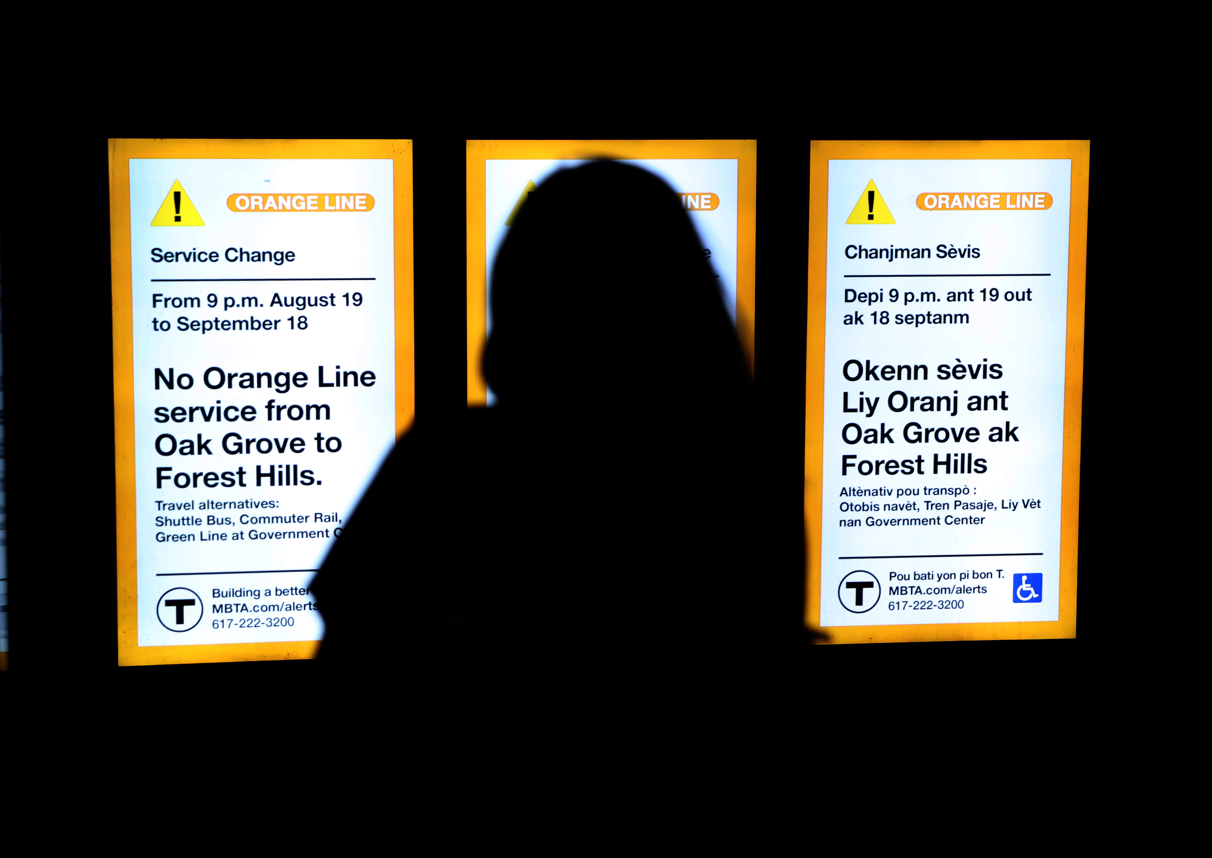
MBTA Route Planner: How to Navigate Orange, Green Line Shutdowns
The mbta built a trip planner to help you plan your commute, and created multiple animations and a rider's guide, by marc fortier • published august 22, 2022 • updated on august 22, 2022 at 6:44 am.
If you usually ride the Orange or Green lines to work or school, your commute just got a bit more complicated with the Orange Line and parts of the Green Line shut down for the next month.
Fortunately, the MBTA has built a Trip Planner tool to help you plan your commute.
See below to find out how to find the best route:
Planning your commute during the Orange Line diversion? Check out our Trip Planner online tool to find the best route for you with customizable features like mode of transit, date, fewest transfers, less walking, and wheelchair accessible. Visit: https://t.co/ljbXZkjs6L pic.twitter.com/EcdgJj9QeV — MBTA (@MBTA) August 19, 2022
Get Boston local news, weather forecasts, lifestyle and entertainment stories to your inbox. Sign up for NBC Boston’s newsletters.
The MBTA has also created a series of animations for the Orange Line and Green Line showing shuttle stops and connections during the shutdown:
To help our riders navigate the Orange Line diversion, we've developed these shuttle animations that take riders through the shuttle stops step-by-step and highlight where to connect for alternate transit options. For SOUTHBOUND service (Oak Grove to Forest Hills), follow along: pic.twitter.com/ZKMDZCXhJb — MBTA (@MBTA) August 18, 2022
Starting Monday, August 22 shuttle buses will replace Green Line service between Union Square & Government Center, along with the Orange Line diversion. To help riders navigate the Green Line shuttle, we made this animation showing shuttle stops & connections for both directions. pic.twitter.com/vrSeF21yAb — MBTA (@MBTA) August 21, 2022
There's also a Rider's Guide to navigating the shutdown:
More MBTA stories
‘So Far, So Good' on Weekday 1 of Orange, Green Line Closures
MBTA Orange, Green Line Shutdown: Live Updates, Maps, Schedule and News
This article tagged under:.
Signature Boston
516,000 square feet of contiguous, nearly column-free exhibit space, 82 meeting rooms, 40,000-square-foot ballroom, and the most advanced convention technology in the industry, including free Wi-Fi access throughout the facility.
176,480 square feet of adaptable exhibit space, auditorium with seating for 4,000+, 38 meeting rooms, and a 24,544-square-foot ballroom, all connected to free Wi-Fi and 3,100+ hotel rooms and 200 shops and restaurants in the heart of Boston’s Back Bay.
Public Transportation
Our public transportation system, the MBTA, or “The T” to locals, connects all of Boston and its suburbs by subway, rail, bus, and even boat! Whether you’re riding by taxi, Amtrak, or The T, our convention centers are conveniently located near several major hubs of public transportation.

The BCEC is steps away from the MBTA’s Silver Line World Trade Center stop, which is the same line that services Logan Airport. Is it a nice day? Take a 15-minute walk from South Station, which serves as one of Boston’s major transportation hubs, with MBTA bus and red line subway service, as well as commuter rail service to across New England, and Amtrak and bus service to many points across the country.

The Hynes Convention Center is conveniently located close to four T stops – the Hynes Convention Center stop, Prudential Center stop, and Copley Square stop on the Green Line and the Back Bay stop on the Orange Line. Need to go to the airport? Hop on the convenient Back Bay Logan Express shuttle , which departs from the Prudential Center at 800 Boylston Street, which is directly connected to the Hynes (*Shuttle service is free from Logan Airport to Back Bay, and $3 for service from Hynes Convention Center to Logan)

Amtrak Service
Boston is a major hub on the Amtrak Northeast corridor railroad system, and connects passengers to not only the rest of New England, but major cities along the entire east coast. Passengers can pick up Amtrak service in Boston at South Station, just minutes from the BCEC; at Back Bay Station, right down the street from the Hynes; or at North Station for Downeaster service from Brunswick, Maine.
Northeast Train Routes
MBTA Trip Planner
The Massachusetts Bay Transportation Authority has a nifty tool called “Trip Planner” that lets you plan your T ride from beginning to end. Simply enter in your starting location at the BCEC or Hynes (or wherever else you find yourself around Boston), and it will tell you where you need to go stop by stop to get here quickly and easily via subway or bus.
Plan your trip

Taxi & Ridesharing
Boston is ripe with car service options. Let one of our transportation agents hail you a cab, or use any of the following services to schedule a pick up:
- Boston Cab: 617.536.5010
- City Cab: 617.536.5100
- Independent Taxi (ITOA): 617.825.4000
- Metro Cab: 617.782.5500
- Top Cab: 617.266.4800
- Town Taxi: 617.536.5000

Alternative Options
Consider taking a pedicab as a fun and affordable way to explore Boston or get anywhere in the city. Boston Pedicab offers regular and pre-scheduled tours and rides at a flexible cost.
Another great alternative to public transportation is Blue Bikes , Boston’s public bike-sharing system with 1,800 city bikes and 180 bike stations throughout the city, including stations directly outside the BCEC and the Hynes.
Zipcar is the world’s largest car sharing service, giving you convenient access to vehicles located all over Boston, including many close to our convention facilities. Simply reserve cars by the hour or day, all for one low rate. Learn how to become a member, reserve a car and hit the road.
Get the latest news and stories from Tufts delivered right to your inbox.
Most popular.
- Activism & Social Justice
- Animal Health & Medicine
- Arts & Humanities
- Business & Economics
- Campus Life
- Climate & Sustainability
- Food & Nutrition
- Global Affairs
- Points of View
- Politics & Voting
- Science & Technology
- Alzheimer’s Disease
- Artificial Intelligence
- Biomedical Science
- Cellular Agriculture
- Cognitive Science
- Computer Science
- Cybersecurity
- Entrepreneurship
- Farming & Agriculture
- Film & Media
- Health Care
- Heart Disease
- Humanitarian Aid
- Immigration
- Infectious Disease
- Life Science
- Lyme Disease
- Mental Health
- Neuroscience
- Oral Health
- Performing Arts
- Public Health
- University News
- Urban Planning
- Visual Arts
- Youth Voting
- Cummings School of Veterinary Medicine
- Friedman School of Nutrition Science and Policy
- The Fletcher School
- Graduate School of Arts and Sciences
- Graduate School of Biomedical Sciences
- Jean Mayer USDA Human Nutrition Research Center on Aging
- Jonathan M. Tisch College of Civic Life
- School of Arts and Sciences
- School of Dental Medicine
- School of Engineering
- School of Medicine
- School of the Museum of Fine Arts
- University College
- Australia & Oceania
- Canada, Mexico, & Caribbean
- Central & South America
- Middle East

Photo: Alonso Nichols
It’s T Time! Tips for Riding the Green Line and Beyond
How do I get a ticket? Can I bring my bike? Is the system accessible?
Read complete coverage of the opening of the new Medford/Tufts Green Line station.
The Massachusetts Bay Transportation Authority (MBTA) subway system, more commonly referred to as the T, is one of the most convenient ways to get around—and with the new Green Line station opening at Tufts University on December 12, this has never been truer. Here are some tips to help you get rolling:
1. Get a CharlieCard
There are three ways to pay for rides on the T: Cash, CharlieTickets, and CharlieCards. While a CharlieTicket is well suited for visitors, CharlieCards can be a better long-term option. These reusable cards have a reduced cost and are available for purchase at fare vending machines in a variety of subway stations. With these, you can purchase seven-day unlimited passes, monthly passes, or cash value. You can easily tap into bus stations and subways with these options, but they aren’t valid on the Commuter Rail (you must purchase separate Commuter Rail passes ).
In addition, please visit the Student Life website for information about how actively matriculated students at Medford/Somerville/SMFA campuses can purchase discounted passes. Employees also have access to many commuter benefits, including discounted MBTA passes . For community members on the Boston/Grafton/Health Sciences campuses, visit the MBTA Passes for Health Science Students webpage for discounted pass program details. For more information regarding employee commuter benefits, visit the Commuter Benefits webpage.
Oh, the Places You'll Go... From Tufts' New Green Line Station!
Tufts' mascot Jumbo rides the T from the Medford/Tufts station to locations all across Boston.
2. Familiarize Yourself with Each Line
The T has a total of five lines , each color-coded based on which parts of the city it runs through: Blue, Green, Orange, Red, and Silver. All of them operate seven days a week, and most trains run from 5 a.m. to 1 a.m. MBTA stations will have inbound and outbound trains—this refers to the direction in which the trains are traveling. Inbound trains approach Boston Common stations while outbound trains travel away from them. A myriad of attractions can be found on each line. Here are some highlights:
Blue Line: New England Aquarium, Belle Isle Marsh Reservation, Christopher Columbus Waterfront Park, the Museum of African American History, and Revere Beach
Green Line: Boston Common, Charles River Esplanade, Symphony Hall, Museum of Fine Arts, Museum of Science, Fenway Park, TD Garden, and the Isabella Stewart Gardner Museum
Orange Line: North End, Faneuil Hall, Chinatown, Tufts Medical Center, Haymarket, and City Hall Plaza
Red Line: State House, Beacon Hill, Boston Common, Children’s Museum, the John F. Kennedy Presidential Museum, and the Boston Harborwalk
Silver Line: Logan Airport, Boston Convention & Exhibition Center, and Boston’s World Trade Center
3. Mind Your Manners: Learn Train Etiquette
While waiting to board a train, the MBTA advises in its list of Rules and Regulations not to immediately enter when the doors open—instead, let other passengers exit first. To make room, especially during rush hour, when you board, move as far away from the doors as possible and only take one seat. Offer your seat when there aren’t any others available to seniors and disabled people. For students, take off your backpack and set it in your lap or on the floor to help save space.
Pets are allowed on the T, but dogs must always be leashed and sit on the floor. Animals other than dogs, like cats and rabbits, are allowed on the T, but must be housed in pet carriers. ( Read more from the MBTA . )
4. Use the MBTA’s Trip Planner
One of the fastest ways to plan a trip on the T is by using the MBTA’s Trip Planner . Simply enter from where you’re departing, your destination, and the date of your trip to get suggestions on routes.
5. Download the Transit App
Download the Transit app from the Apple Store or Google Play to plan your trips all in one place. You can use the app to find the nearest T station, see what time the next train is arriving, and navigate to your destination with step-by-step instructions.
6. Know How the T Is Accessible
Most T stations are accessible for disabled people , and the MBTA offers trip planning assistance if needed. Additionally, disabled people may be eligible for reduced fares. To ensure your trip is accessible, there are a few options. First, you can visit the MBTA’s subway station list and find stations marked with the International Symbol of Accessibility (or the “wheelchair symbol”). You could also use the Trip Planner and select “Wheelchair accessible” so that you’ll receive only accessible travel suggestions. MBTA Customer Support will also help plan your trip over the phone as long as you have a starting location, destination, and date and time of travel. They can be reached at 617-222-3200. For more information about accessibility on the T, read their accessibility access guide here .
7. Learn About Bike Rules
Can I bring my bike on the T? While bikes are never allowed on the Green Line or Mattapan Trolley, bikes are otherwise permitted on many lines, including on weekends—but not during rush hour. Bikes are not allowed on the T during the hours of 7–10 a.m. and 4–7 p.m. Also, bikes aren’t allowed on at the Park Street, Downtown Crossing, or Government Center stations. If you’re taking the bus, you can bring your bike by putting it on the bike rack at the front of the vehicle (each can carry two bikes). If you’re bringing your bike on trains where and when bikes are allowed, you can use the elevator to get to the platform or carry it down the stairs, but you aren’t allowed to ride your bike inside the station. Visit the MBTA’s website for all rules on bikes .

Oh, the Places You’ll Go... From Tufts’ New Green Line Station!
Fast facts: the green line expansion project.

New MBTA Green Line Station to Be Named Medford/Tufts
Official websites use .mass.gov
Secure websites use HTTPS certificate
A lock icon ( ) or https:// means you’ve safely connected to the official website. Share sensitive information only on official, secure websites.
- search across the entire site
- search in Office of the Attorney General
- This page, MBTA Communities Law Q&A, is offered by
- Office of the Attorney General
MBTA Communities Law Q&A
Table of contents, (1) what is the mbta communities law and what does it require.
The MBTA Communities Act was adopted in January 2021, as part of legislation to strengthen the state’s economy. It was passed by broad bipartisan majorities in the legislature — the Senate voted unanimously in favor of the Act, and the House voted 143 in favor to 4 against. Governor Baker signed the Act into law on January 14, 2021. [Source: H.5250 (2020)]
The MBTA Communities Act requires 177 Cities and Towns to establish “at least 1 district of reasonable size in which multi-family housing is permitted as of right.” Where possible, the district must be within a half mile from public transportation (commuter rail, bus station, ferry terminal or subway). MBTA Communities must permit the development of housing suitable for families with children, and may not impose age restrictions, within the district.
The state agency with responsibility for housing issues, known as the Executive Office of Housing and Livable Communities (or EOHLC), has detailed materials available to address questions about this law and help communities understand their obligations. Those materials are available here .
(2) Is compliance with the law mandatory?
Yes. The law states clearly that 177 communities covered by the MBTA Communities Law “shall have a zoning ordinance or bylaw that provides for at least 1 district of reasonable size” that permits multi-family housing as of right.
The Attorney General’s Office has issued an advisory on this issue, which is available here .
(3) What Cities and Towns are subject to the law?
Communities that are served by the MBTA are subject to the law, including:
- 84 communities that host MBTA service, including rapid transit, commuter rail, ferry or bus.
- 93 communities that abut — that is, share a border with — a City or Town that is served by the MBTA.
The following map demonstrates the location of MBTA Communities throughout the Commonwealth:

(4) Is the MBTA Communities Act constitutional?
Yes, it is. Under the state constitution, our state legislature has the power to pass laws about municipal zoning. Mass. Const. Art. Amend. art. 60. In the words of our state supreme court, this gives the state the “supreme power” in zoning matters.
In many cases, the legislature has passed laws that emower local communities to make their own decisions about zoning. In some cases, though, the legislature has determined that local discretion should be limited in order to allow development that will further state or regional interests. For example, the legislature has set statewide standards when it comes to housing development for low- and moderate-income residents (under Chapter 40B); as well as schools, churches and other religious institutions, certain agricultural uses, child care centers, congregate care for those with disabilities, and solar power installations (under G.L. c. 40A, § 3).
Litigation has challenged Chapter 40B based on an argument that the state cannot require communities to allow low- and moderate-income housing developments that would otherwise violate local zoning. But those challenges have failed because the constitution gives the state the authority to restrict local zoning. The state supreme court has consistently required municipalities to comply with state law that allows educational, religious, childcare, and solar developments, over community objections.
The state legislature had the authority to pass the MBTA Communities Law to require multi-family housing districts in 177 communities where public transportation is accessible. The state is particularly interested in such development because Massachusetts is facing a housing crisis that is crowding out people who wish to live and work here, hurting our communities and limiting our economic growth. The legislature also chose to preserve significant local discretion to determine where that housing may be allowed in order to meet the particular needs of each community.
(5) Does the MBTA Communities Law allow for municipal discretion?
Yes. The MBTA Communities Law and Compliance Guidelines established by the state require that multi-family housing districts must be of reasonable size and, where feasible, located near mass transit; they must allow housing suitable for families with children; and they cannot be age-limited.
As long as they meet those requirements, communities have considerable discretion as to where to locate multi-family districts and how big those districts may be.
(6) Are there resources available to assist covered communities with compliance?
Yes. The Attorney General’s Office and the Executive Office of Housing and Livable Communities (EOHLC) have collected materials here and here . Municipal planners may seek EOHLC’s assistance and communities may be eligible for (or may already have received) grant funding to help design compliant districts. In addition, Massachusetts Housing Partnership (MHP) offers consultant services to assist with technical aspects of compliance and Citizens' Housing and Planning Association (CHAPA) provides assistance to municipalities around public education and engagement. Regional Planning Agencies also provide technical assistance to their municipalities. Taken together, over $6 million in technical assistance has been provided to 156 of the 177 municipalities since August 2022.
Municipal counsel are encouraged to reach out to the Attorney General’s Municipal Law Unit with questions on compliance. Both EOHLC and the Attorney General’s Office have offered pre-review for proposed districts to give municipalities guidance as to whether the district is likely to be approved.
(7) Does the MBTA Communities Law impermissibly limit local control?
No. The state legislature has the power to enact zoning laws with which communities must comply. The power is set forth in Article 60 of the Amendments to the state constitution. That power is specifically preserved by the Home Rule Amendment, which requires municipalities to follow state law, like the MBTA Communities Law. Mass. Const. Art. Amend. art. 89, § 8.
In addition, the MBTA Communities Act ensures communities can determine where the required district is (or districts are) located and how large they are, within certain parameters.
(8) Are the Guidelines adopted by the state binding on my community?
Yes, they are. State law requires the state — and, specifically, the Executive Office of Housing and Livable Communities, known as EOHLC — to “promulgate guidelines to determine if an MBTA Community” is in compliance with its obligations.
These guidelines are binding. We are aware of suggestions that guidelines are somehow non-binding because they are not “regulations.” But our state supreme court has recently rejected an argument that EOHLC guidelines are nonbinding. See Fairhaven Hous. Auth. v. Commonwealth , 493 Mass. 27 (2023).
(9) How can zoning that is compliant with the MBTA Communities Law by adopted?
One or more zoning districts that are consistent with the MBTA Communities Act may be adopted through the typical municipal process for adopting zoning ordinances or bylaws. That means in certain towns, an approval of Town Meeting or Representative Town Meeting will be required (in an annual or specially-called meeting), following action by the appropriate municipal board (e.g., the Select Board or the Planning Board). In cities, approval by the City Council is required. A few municipalities may have existing zoning that complies with the Guidelines in which case they should submit a complete application to EOHLC for a determination of compliance.
(10) What do MBTA Communities have to do, and by when?
The MBTA Communities Act simply required cities and towns to “have” a zoning ordinance or by-law that provides for at least one district of reasonable size in which multi-family housing is permitted as of right and meets the other requirements of the Act. However, EOHLC recognized that many communities would need time to craft and pass an appropriate district, and therefore created a process by which communities can be treated as being in compliance by taking concrete steps towards adopting the necessary zoning ordinance or by-law.
Communities served by MBTA rapid transit (the subway, trolley, or Silver Line buses) were required to submit a zoning ordinance or bylaw to EOHLC for approval by December 31, 2023. Of the 12 communities subject to that deadline, only Milton has failed to submit a zoning ordinance or bylaw for approval.
Most of the remaining communities covered by the law—those served by commuter rail, bus, or ferry, or adjacent to such a community—must submit their zoning ordinance or bylaw for EOHLC approval by December 31, 2024. Certain smaller adjacent communities are allowed until December 31, 2025.
The deadline applicable to each community can be located in the EOHLC Guidelines, which are available here .
The zoning ordinance or bylaw that a community adopts must comply with EOHLC Guidelines. However, if they submit by their deadline, MBTA Communities will be treated as compliant with the law while EOHLC is reviewing their submission.
(11) What happens if my City or Town fails to comply with the MBTA Communities Law?
Communities that fail to comply with the MBTA Communities Act automatically lose certain state funding, including funding: for local infrastructure generally, such as road, bridge, water and sewer improvements (known as MassWorks); for local infrastructure projects that support housing (known as HousingWorks); for EOHLC grants to communities with a “Housing Choice” designation; and state funding under the Local Capital Projects Fund.
In addition, the Healey-Driscoll Administration has notified communities that compliance with the MBTA Communities Act will be considered when dispensing certain discretionary local aid. Several programs potentially affected by that consideration are catalogued here .
In addition, intentional or persistent non-compliance may result in an enforcement action against the municipality by the Attorney General. Any such action would seek a court order requiring the community to comply with the law. Such a lawsuit is currently pending in the state supreme court against the Town of Milton.
(12) The following questions might be asked by residents preparing to attend a Town Meeting where a new zoning district will be considered:
- How did my community settle upon the district presented for Town Meeting consideration?
This answer will vary for each community. At a minimum, each community held a public Planning Board hearing on the proposed district, at which residents could participate. After the hearing the Planning Board was required to issue a report to Town Meeting or City Council with a recommendation concerning whether or not the zoning district should be adopted.
Many communities also held preliminary workshops or public comment meetings on proposed MBTA Communities zoning districts. In many cases, proposed zoning districts are drafted with help from planning consultants, often hired with grant money provided by Commonwealth agencies. Like every other zoning bylaw, the zoning district is drafted with input from the Town/City Planner, the Planning Board, and the Select Board or City Council.
- What vote is required in order for the new district to pass?
A simple majority vote.
- What happens if the proposed zoning district passes?
It is submitted to the Executive Office of Housing and Livable Communities (EOHLC) to ensure that the district is compliant with the MBTA Communities Act. EOHLC offers an optional “pre-adoption” review of proposed districts before they are voted on, in which case the community will have some indication as to whether the zoning district is likely to be approved.
As with all other town zoning bylaws, a town’s MBTA Communities zoning bylaw also will be submitted to the Attorney General’s Office for review and approval as required by statute. Once the zoning bylaw is approved, it will take effect, and multi-family housing will be permitted in the new zoning district. Please note that EOHLC determinations of compliance are separate from the bylaw review by the Attorney General’s Office and that a bylaw approved by the Attorney General will be in effect even if EOHLC makes a determination that the bylaw does not comply with the Guidelines and the Act.
- What happens if the proposed zoning district does not pass?
This answer will depend on the time of the Town Meeting or City Council vote and whether the community will be able to come into compliance in advance of the applicable deadline (which, for many communities, will be December 31, 2024). If the vote renders the community out of compliance, the community will face the consequences set forth in response to question 11, above.
Help Us Improve Mass.gov with your feedback
The feedback will only be used for improving the website. If you need assistance, please Contact the Attorney General's Office at (617) 727-2200 . Please limit your input to 500 characters.
Thank you for your website feedback! We will use this information to improve this page.
If you would like to continue helping us improve Mass.gov, join our user panel to test new features for the site.
Road closures and parking restrictions on Marathon weekend and Patriots Day

Follow along with live updates from the Boston Marathon
The Boston Marathon will bring thousands of spectators and runners — some with elite and celebrity status — to the city on Monday.
City officials are urging spectators to take public transit, walk, or bike on race day, and the Boston Athletic Association released a spectator guide full of useful information.
Marathon weekend is marked by several events including two races on Saturday, a BAA 5K and Invitational Mile, and the Patriots’ Day Parade on Monday, which begins at 9:15 a.m. at City Hall Plaza and marches to Paul Revere Mall. And then, of course, there’s the big race on Monday, too.
Advertisement
Boston, Newton, and Brookline have released parking restrictions and road closures along the Marathon route that go into effect before the race. And the BAA has released details about closure along the route as well.
Here’s what to expect.
Boston Marathon
- Parking meters are free in Boston on Monday
- A map of Boston road closures on Monday from the City of Boston Office of Emergency Management
- Hopkinton , 7:15 a.m. to 1:30 p.m.
- Ashland, 7:15 a.m. to 1:20 p.m.
- Framingham , 7:30 a.m. to 1:55 p.m.
- Natick , 8:30 a.m. to 2:45 p.m.
- Wellesley , 8:30 a.m. to 3:35 p.m.
- Newton , 8 a.m. to 4:45 p.m.
- Brookline, 9 a.m. to 5:45 p.m.
- Boston , varying until 7 p.m.
- Here is a map of Boston road closures on Monday, from the City of Boston Office of Emergency Management
Street-by-street parking restrictions in Boston before and after the Marathon (and during, of course)
No stopping in through Thursday, April 18:
- Exeter Street , on the east side, from Boylston Street to Blagden Street
- Blagden Street , on the south side, opposite the library, from Huntington Avenue to Exeter Street
- Blagden Street , on the north side, library side, from BPL Driveway to Exeter Street
- Blagden Street , on the north side, from Dartmouth Street to BPL Driveway
- Boylston Street , from Exeter Street to Dartmouth Street
- Boylston Street , from Dartmouth Street
No stopping through Tuesday, April 16:
- Exeter Street , on the west side, from Alley 441 to Boylston Street
No stopping Friday, Saturday, and Monday:
- Beacon Street , on the south side, Boston Common side, from Charles Street to Joy Street
- Boylston Street , from Dalton Street to Dartmouth Street, unless otherwise posted
- Dartmouth Street , from Boylston Street to Commonwealth Avenue
- Exeter Street , from Newbury Street to Huntington Avenue, unless otherwise posted
No stopping through Monday:
- Clarendon Street , from Newbury Street to Stuart Street
No stopping Saturday through Monday:
- Beacon Street , from Bay State Road to Brookline town line
- Berkeley Street , from Stuart Street to Newbury Street
- Boylston Street , from Dartmouth Street to Charles Street, unless otherwise posted
- Cambridge Street , from Court Street to Sudbury Street
- Charles Street , from Boylston Street to Beacon Street
- Saint James Avenue , from Arlington Street to Dartmouth Street
- Stuart Street , from Huntington Avenue to Arlington Street
No stopping Sunday and Monday:
- Clarendon Street , from Public Alley 436 to Newbury Street
- Newbury Street , for Media Vehicles, from 29 Newbury St. crossing over Berkeley Street to 69 Newbury St.
No stopping Saturday at 12:01 a.m. through 3 p.m.:
- Newbury Street , from Dartmouth Street to Exeter Street
No stopping Monday:
- Arlington Street , from Beacon Street to Isabella Street
- Beacon Street in Brighton , from Chestnut Hill Avenue to Brookline town line
- Beacon Street in Back Bay , on the south side, Public Garden side, from Charles Street to Arlington Street
- Berkeley Street , from Columbus Avenue to Commonwealth Avenue, unless otherwise posted
- Belvidere Street , from Huntington Avenue to Massachusetts Avenue
- Boylston Street , from Massachusetts Avenue to Dalton Street
- Cambria Street , from Boylston Street to the loading dock of the Hynes Center
- Charles Street South , from Park Plaza to Boylston Street
- Chestnut Hill Avenue , from Commonwealth Avenue to Beacon Street
- Clarendon Street , from Commonwealth Avenue to Columbus Avenue, unless otherwise posted
- Cleveland Circle , in the parking area adjacent to Cassidy Playground, parking area adjacent to Sutherland Road, from Beacon Street to Chestnut Hill Avenue
- Columbus Avenue , from Arlington Street to Dartmouth Street
- Commonwealth Avenue, on the south, inbound side, from Beacon Street in Kenmore Square to 80 degrees east of Hereford Street (the section of roadway between the entrance to the Massachusetts Avenue underpass and Massachusetts Avenue does not need to be posted)
- Commonwealth Avenue, inbound, from Lake Street to Chestnut Hill Avenue
- Dartmouth Street , from Saint James Avenue to Columbus Avenue
- Deerfield Street , from Commonwealth Avenue to Bay State Road
- East Dedham Street , from Harrison Avenue to Albany Street
- Exeter Street , from Commonwealth Avenue to Newbury Street
- Fairfield Street , from Boylston Street to Commonwealth Avenue
- Gloucester Street , from Commonwealth Avenue to Boylston Street
- Hereford Street , from Commonwealth Avenue to Boylston Street
- Hanover Street , for the Patriots’ Day Parade, from Congress Street to Commercial Street
- Kenmore Street , from Newbury Street to Beacon Street
- Nassau Street , from Washington Street to Harrison Avenue
- Newbury Street , from Arlington Street to Brookline Avenue
- Plympton Street , from Harrison Avenue to Albany Street
- Raleigh Street , from Bay State Road to Beacon Street
- Stanhope Street , from Berkeley Street to Clarendon Street
- Scotia Street , from Dalton Street to St. Cecilia Street
- St. Cecilia Street , from Belvidere Street to Boylston Street
- Washington Street , from Oak Street to Nassau Street
- East side , on the even side from Nassau Street to Kneeland Street
- Blagden Street , from Huntington Avenue to Exeter Street, unless otherwise posted
- Congress Street , on the north side, Faneuil Hall side, for the Patriots’ Day Parade, from State Street to Hanover Street
- Commonwealth Avenue , heading outbound from Charlesgate West to Deerfield Street
- Dalton Street , from Boylston Street to Clearway Street
- Huntington Avenue , on the northwest, odd side, from Blagden Street to Massachusetts Avenue
- New Chardon Street , from Merrimac Street to Cambridge Street
- Providence Street , from Arlington Street to Berkeley Street
- State Street , for the Patriots’ Day Parade, from Congress Street to Washington Street
- Tremont Street , for the Patriots’ Day Parade, from Cambridge Street/Beacon Street to Stuart Street
- Washington Street, for the Patriots’ Day Parade, from Winter Street to State Street
- Winter Street , for the Patriots’ Day Parade, from Tremont Street to Washington Street
Family meeting areas near race finish
- Clarendon Street
- Saint James Avenue
- Stuart Street
No stopping – Boston Athletic Association vehicles only:
- Trinity Place , on the west side, hotel side, from St. James Avenue to Stuart Street
- Copley station , closed all day
- Green line stations, South Street (B line), Kent Street (C line), and Saint Mary’s Street (C line) , closed from about 10 a.m. to 6 p.m.
- Green, Red, Orange, Blue, and Silver MBTA lines will operate on a regular weekday schedule with additional service before and after the Marathon
- Bikes , including folding bikes, are not allowed on MBTA trains Monday
- Worcester commuter rail line will have additional inbound and outbound trains
- All other commuter rail lines will operate on a regular weekday schedule, bikes and scooters, including folding ones, will not be allowed on board Worcester Line trains starting on Sunday at 5 p.m. until end of service on Monday
- The Ride will operate on a regular weekday schedule, but may be detoured to accommodate the Marathon and related events
- Ferries will operate on a regular weekday schedule
- For more information, check the MBTA’s website or use the MBTA Trip Planner
No parking tow zone through Monday at 7 p.m.:
- Commonwealth Avenue Carriage Lane , from Washington Street to the Boston line
No parking tow zone Monday 12 a.m.-7 p.m.:
- Washington Street , from the Wellesley line to Auburn Street
- Commonwealth Avenue , from Auburn Street to the Boston line
- All feeder streets along the race route, within 60 feet of the route and on the fire hydrant side of the street
- Beacon Street , from Washington Street to Dorset Road
- Beacon Street extension , north of Washington Street
- Centre Street , from Homer Street to Ward Street
- Chestnut Street , from Beacon Street to Highland Street
- College Road , from Beacon Street to Commonwealth Avenue
- Concord Street , from Hagar to Washington Street
- Dorset Road , from 1947 Beacon St. to 215 Dorset Road
- Evelyn Road , from 192 Evelyn Road to Fuller Street and from Paulson Road to Mary Ellen Road
- Evelyn Road , on the odd side, from Beacon Street to Paulson Road
- Fuller Street , from Day Street to Evelyn Road
- Grant Avenue , from Montvale Road to Ward Street
- Grove Street , from Washington Street to Woodland Road
- Hammond Street , from Ward to Beacon Street
- Homer Street , from Commonwealth Avenue to Centre Street
- Lowell Avenue , from Commonwealth Ave to Hull Street
- Maple Street , from Woodland Road to Auburn Street
- Old Colony Road , from Priscilla to Commonwealth Avenue
- Quinobequin Road , from Interstate 95 southbound ramp to Washington Street
- Walnut Street , from Homer Street to Mill Street
- Ward Street , from Centre Street to Manet Road
- Woodland Road , from Grove Street to Washington Street
Road closures Monday from 8 a.m. until 7 p.m.:
- Washington Street , from the Wellesley Line to Auburn Street
- All feeder streets , along race route will be closed 60 feet back from the route
Secondary Roads/Feeder Streets:
- Beacon Street Extension , north of Washington Street
- Beacon Street , from Hammond Street to Boston line (residents only)
- Chestnut Street , from Beacon Street to Highland Street (residents only)
- Evelyn Road , from 192 Evelyn Road to Fuller Street
- Fuller St , from Day Street to Evelyn Road (residents only)
- Grant Avenue , from Beacon Street to Ward Street (residents only)
- Grove Street , from Washington to Moulton Street
- Hammond Street , from Ward to Hammondswood Road
- Helene Road and Cotter Road , from Paulson to Fuller
- Lowell Avenue , from Commonwealth Avenue to Hull Street (residents only)
- Quinobequin Road, from Interstate 95 southbound ramp to Washington Street
- Walnut Street , from Horner Street to Mill Street (residents only)
- Ward Street , from Hammond to Manet (residents only)
- Woodland Road , from Cheswick Road to Washington Street
- No vehicle will be allowed to cross the Marathon route or access the Carriage Lane of Commonwealth Avenue
- All effected streets will be posted with No Parking – Tow Zones signs
One-way streets Monday from 8 a.m. until 6 p.m.:
- Maple Street , from Woodland Road to Central Street
- Evelyn Road , from 118 Evelyn Road to 180 Evelyn Road
- Mary Ellen Road , from 180 Evelyn Road to 110 Evelyn Road
Brookline road closures:
Road Closures Monday from 8 a.m. to 4:45 p.m.:
- Beacon Street, eastbound, priority towing and westbound, all medians and gutters
- Chestnut Hill Avenue at Clinton Road and Dean Road
- St Mary’s Street to Monmouth Street
- Carlton Street to Monmouth Street
- Hawes Street to Chatham Street
- Borland Street to Chatham Street
- Kent Street to Chatham Street
- Marshall Street to Sewall Avenue
- St Paul Street to Sewall Avenue
- Charles Street to Sewall (except for media parking)
- Harvard Street to Sewall Avenue
- Sewall Avenue between Harvard and Longwood Avenue
- Webster Street , entire length, but traffic will be allowed in both directions
- Longwood Avenue between Harvard Street and Sewall Avenue
- Park Street to Marion Street
- Marion Street to St Marks Park
- Washington Street to BFD Washington Square Station
- Fairbanks Road , entire length
- University Road to 100 University Road
- Winthrop Road to Garrison Road
- Tappan Street to Garrison Road
- Dean Road to Beaconsfield
- Clinton Path to Strathmore Road
- Strathmore Road to 21 Strathmore Road
Ava Berger can be reached at [email protected] . Follow her @Ava_Berger_ .
Official websites use .boston.gov
A .boston.gov website belongs to an official government organization in the City of Boston.
Secure .gov websites use HTTPS
) or https:// means you've safely connected to the .gov website. Share sensitive information only on official, secure websites.
2024 Boston Marathon Traffic Advisory
Parking restrictions and street closures will be in effect in the City of Boston for Patriots Day and the Boston Marathon
The Marathon Weekend Events this year will have two main races on the Saturday before the running of the 2024 Boston Marathon. In addition to the events hosted by the Boston Athletic Association, the City of Boston will host Boston One Day on April 15, 2024, and the Patriots’ Day Parade on Monday, April 15, 2024. Parking restrictions will be in place for all of these events. Please plan accordingly and follow all posted signage.
People coming into the City for the events are urged not to drive their personal vehicles. Information on Bluebike rentals may be found on the Bluebikes website and public transit information can be found on the MBTA website . For a faster return trip, the MBTA advises riders to purchase a round-trip rather than a one-way ticket. Walking is also a great way to move around Boston.
Changes to the restrictions on this page may be made by the City of Boston’s Police and Transportation Departments. It is important to read all posted signs and variable message boards carefully.
- Last updated: April 12, 2024
Boston Marathon Map

Download the Map
Roadway Closures and Parking Restrictions
Race route:.
B.A.A. 5K route begins on Charles Street heading:
- southerly to Boylston Street
- west on Boylston Street
- north on Arlington Street
- west on Commonwealth Avenue Outbound using the underpass at Massachusetts Avenue
- south on Charlesgate West
- east onto Commonwealth Avenue Inbound using the underpass at Massachusetts Avenue
- south on Hereford Street
- east on Boylston Street, and
- then north on Charles Street.
The starting time is 8 a.m. and organizers expect 6,500 participants.
Parking restrictions will be in place on the following streets:
- Formation: Charles Street between Beacon Street and Boylston Street
- Charles Street-from Boylston Street to Beacon Street
- Arlington Street from Marlborough Street to Boylston Street
- Commonwealth Avenue Outbound from Arlington Street to Charlesgate West
- Charlesgate West from Commonwealth Avenue Outbound to Commonwealth Avenue Inbound
- Commonwealth Avenue Inbound from Charlesgate West to Hereford Street
- Hereford Street from Commonwealth Avenue to Boylston Street
- Boylston Street from Dalton Street to Charles Street
Invitational Mile Route
The Invitational Mile begins on:
- Boylston Street near Exeter Street
- turning left onto Dartmouth Street
- turning left onto Newbury Street
- turning left onto Boylston Street, and
- ending at the Boston Marathon Finish Line.
The route will be posted with "No Stopping" signs in the areas that will not already be posted because of the Boston Marathon. The start time is 10:30 a.m.
- Formation: Boylston Street near Exeter Street
- Boylston Street, From Exeter Street to Dartmouth Street
- Dartmouth Street, From Boylston Street to Newbury Street
- Newbury Street, From Dartmouth Street to Exeter Street
- Exeter Street, From Newbury to Boylston Street
Parade Route
The Patriots’ Day Parade begins with a ceremony at City Hall Plaza. The parade will kick off about 9:15 a.m.
The parade route is:
- Court Street
- Cambridge Street
- Tremont Street
- Winter Street
- Washington Street
- State Street
- Congress Street, and
- Hanover Street ending at the Paul Revere Mall.
Organizers expect 500 attendees.
- Congress Street (north side, Faneuil Hall side), State Street to Hanover Street
- Hanover Street (both sides), Congress Street to Commercial Street
- State Street (both sides), Congress Street to Washington Street
- Tremont Street (both sides), Cambridge Street/Beacon Street to Stuart Street
- Washington Street (both sides), Winter Street to State Street
- Winter Street (both sides), Tremont Street to Washington Street
Various parking restrictions will be in place to support the running of the 128th Boston Marathon.
No Stopping April 8 - 18
- Exeter Street (east side) Boylston Street to Blagden Street
- Blagden Street (south side, opposite side of library), from Huntington Avenue to Exeter Street
- Blagden Street (north side, library side), BPL Driveway to Exeter Street
- Boylston Street (both sides), Exeter Street to Dartmouth Street
- Boylston Street from Dartmouth Street
- Blagden Street (north side), Dartmouth Street to BPL Driveway
No Stopping April 10 - 16
- Exeter Street (west side). Alley 441 to Boylston Street
No Stopping: Friday, Saturday, and Monday
- Beacon Street (south side, Boston Common side), Charles Street to Joy Street
- Boylston Street (both sides), Dalton Street to Dartmouth Street, unless otherwise posted
- Dartmouth Street (both sides), Boylston Street to Commonwealth Avenue
- Exeter Street (both sides), Newbury Street to Huntington Avenue, unless otherwise posted.
No Stopping: Thursday to Monday
- Clarendon Street (both sides), Newbury Street to Stuart Street
No Stopping: Saturday to Monday
- Beacon Street, Bay State Road to Brookline Town Line (both sides)
- Berkeley Street (both sides), Stuart Street to Newbury Street
- Boylston Street (both sides), Dartmouth Street to Charles Street, unless otherwise posted
- Cambridge Street (both sides), Court Street to Sudbury Street
- Charles Street (both sides), Boylston Street to Beacon Street
- Saint James Avenue (both sides), Arlington Street to Dartmouth Street
- Stuart Street (both sides), Huntington Avenue to Arlington Street
No Stopping: Sunday and Monday
- Clarendon Street (both sides), Public Alley 436 to Newbury Street
- Newbury Street (both sides) for Media Vehicles, #29 Newbury Street crossing over Berkeley Street to #69 Newbury Street
No Stopping: Saturday 12:01 a.m. through 3 p.m.
- Newbury Street (both sides), Dartmouth Street to Exeter Street
No Stopping: Monday
- Arlington Street (both sides), Beacon Street to Isabella Street
- Beacon Street, Brighton (both sides), Chestnut Hill Avenue to Brookline Line
- Beacon Street, Back Bay (South side, Public Garden side), Charles Street to Arlington Street
- Berkeley Street (both sides), Columbus Avenue to Commonwealth Avenue, unless otherwise posted
- Belvidere Street (both sides), Huntington Avenue to Massachusetts Avenue
- Boylston Street (both sides), Massachusetts Avenue to Dalton Street
- Cambria Street (both sides), Boylston Street to the loading dock of the Hynes Center
- Charles Street South (both sides), Park Plaza to Boylston Street
- Chestnut Hill Ave. (both sides), Commonwealth Avenue to Beacon Street
- Clarendon Street (both sides), Commonwealth Avenue to Columbus Avenue, unless otherwise posted
- Cleveland Circle (both sides), (Parking area adjacent to Cassidy Playground parking area adjacent to Sutherland Road) from Beacon Street to Chestnut Hill Avenue, 24 hours
- Columbus Avenue (both sides), Arlington Street to Dartmouth Street
- Commonwealth Avenue (south, inbound, side), Beacon Street (Kenmore Square) to 80’ east of Hereford Street, the section of roadway between the entrance to the Massachusetts Avenue underpass and Massachusetts Avenue does not need to be posted.
- Commonwealth Avenue, Lake Street to Chestnut Hill Avenue (inbound)
- Dartmouth Street (both sides), Saint James Avenue to Columbus Avenue
- Deerfield Street (both sides), Commonwealth Avenue to Bay State Road
- East Dedham Street (both sides), Harrison Avenue to Albany Street
- Exeter Street (both sides), Commonwealth Avenue to Newbury Street
- Fairfield Street (both sides), Boylston Street to Commonwealth Avenue
- Gloucester Street (both sides), Commonwealth Avenue to Boylston Street
- Hereford Street (both sides), Commonwealth Avenue to Boylston Street
- Hanover Street (both sides) for Patriot’s Day Parade, Congress Street to Commercial Street
- Kenmore Street (both sides), Newbury Street to Beacon Street
- Nassau Street (for Tufts Medical), Both sides, from Washington Street to Harrison Avenue
- Newbury Street (both sides), Arlington Street to Brookline Avenue excluding the section already posted from #29 to #69 Newbury also over post any other signs on Dartmouth Street to Exeter Street
- Plympton Street (both sides), Harrison Avenue to Albany Street
- Raleigh Street (both sides), Bay State Road to Beacon Street
- Stanhope Street (both sides), Berkeley Street to Clarendon Street
- Scotia Street (both sides), Dalton Street to St. Cecilia Street
- St. Cecilia Street (both sides), Belvidere Street to Boylston Street
- Washington Street (for Tufts Medical), Both sides, from Oak Street to Nassau Street
- East side (even side), from Nassau Street to Kneeland Street
- Blagden Street (both sides), Huntington Avenue to Exeter Street, unless otherwise posted
- Congress Street (north side, Faneuil Hall side) for Patriot’s Day Parade, State Street to Hanover Street
- Commonwealth Avenue, Charlesgate West to Deerfield Street (outbound)
- Dalton Street (both sides), Boylston Street to Clearway Street
- Huntington Avenue (northwest side, odd side), Blagden Street to Massachusetts Avenue
- New Chardon Street (both sides), Merrimac Street to Cambridge Street
- Providence Street (both sides), Arlington Street to Berkeley Street
- State Street (both sides) for Patriot’s Day Parade, Congress Street to Washington Street
- Tremont Street (both sides) for Patriot’s Day Parade, Cambridge Street/Beacon Street to Stuart Street
- Washington Street (both sides) for Patriot’s Day Parade, Winter Street to State Street
- Winter Street (both sides) for Patriot’s Day Parade, Tremont Street to Washington Street
Family Meeting Area
- Clarendon Street
- Saint James Avenue
- Stuart Street
No Stopping: BAA Vehicles Only
- Trinity Place (west side, hotel side), St. James Avenue to Stuart Street
Getting Into the City

Thinking about driving?
If you can, please avoid driving into the City. Consider using Bluebikes , the regional bike share system, or use public transit through the MBTA .

Parking and Traffic Updates
We may make changes to our traffic and parking plans in the days leading up to these events. You’ll find updated information on posted signs, variable message boards, and on Boston.gov .

Keep in mind
Don't forget about walking! It's a great way to move around the City. We more information on traveling around Boston in our guide:
Related Resources
Get the latest Boston Marathon information from the Boston Athletic Association.

IMAGES
VIDEO
COMMENTS
All MBTA Improvement Projects. Home Trip Planner Trip Planner From (Required) A. To (Required) B. There was a problem performing your search; please try again in a few minutes. Depart at 6:55 PM, 4/14/24 Schedule By Arrival or Departure: Depart at Arrive by Hour. Minute ...
Official website of the MBTA -- schedules, maps, and fare information for Greater Boston's public transportation system, including subway, commuter rail, bus routes, ... Choose your origin and destination to calculate your fare with our Trip Planner. From (Required) A. To (Required) B. There was a problem performing your search; please try ...
Subway one-way: $2.40 with cash, CharlieCard, or CharlieTicket. The MBTA operates 171 bus routes and 4 rapid transit routes in the Greater Boston area, with connections to the subway and Commuter Rail. Local bus one-way: $1.70 with cash, CharlieCard, or CharlieTicket. The Commuter Rail connects eastern Massachusetts with transit hubs in Boston ...
Transit App. The MBTA officially endorsed this free app back in 2016.It basically mimics the agency's own Trip Planner site via tapping into the MBTA's real-time data for arrivals and departures.
Subway Lines: The T consists of five separate lines, each of which connects at several locations within the city. The Green Line began as America's first underground subway system in 1897. Today, the line consists of four separate branches (be sure to get on the right one). The other lines are the Red Line, Blue Line, Orange Line and Silver Line.
Check out our Trip Planner online tool to find the best route for you with customizable features like mode of transit, date, fewest transfers, less walking, and wheelchair accessible. The MBTA has also created a series of animations for the Orange Line and Green Line showing shuttle stops and connections during the shutdown:
Rescheduling a missed trip. Not all changes can be accommodated, so call TRAC at 844-427-7433 (voice/relay) or 857-206-6569 (TTY) as soon as possible if you're delayed or something changes. Calling TRAC to request a new pick-up time will result in a premium non-ADA fare of $5.60.
MBTA Trip Planner. The Massachusetts Bay Transportation Authority has a nifty tool called "Trip Planner" that lets you plan your T ride from beginning to end. Simply enter in your starting location at the BCEC or Hynes (or wherever else you find yourself around Boston), and it will tell you where you need to go stop by stop to get here ...
One of the fastest ways to plan a trip on the T is by using the MBTA's Trip Planner. Simply enter from where you're departing, your destination, and the date of your trip to get suggestions on routes. 5. Download the Transit App. Download the Transit app from the Apple Store or Google Play to plan your trips all in one place. You can use ...
MBTA-Endorsed Apps. There are a variety of smartphone apps to help you plan trips on the MBTA, buy Commuter Rail tickets, pay for parking, and report safety concerns to the Transit Police. All MBTA apps are available for free from Google Play and the Apple App Store.
Projects. Safety and Security. Transparency. Guides. Contact the MTA. Media Relations. Procurement and solicitations. Schedules Maps Fares & Tolls Planned Work.
The MBTA Communities Act was adopted in January 2021, as part of legislation to strengthen the state's economy. It was passed by broad bipartisan majorities in the legislature — the Senate voted unanimously in favor of the Act, and the House voted 143 in favor to 4 against. Governor Baker signed the Act into law on January 14, 2021.
For more information, check the MBTA's website or use the MBTA Trip Planner. Trash/recycling collection: Trash and recycling pickups are delayed in some Boston neighborhoods until the following ...
According to MBTA Transit Police, "unknown person/s" left the dinghy on the Fitchburg Line right of way around 12:15 a.m. In a post on X, transit police said the commuter rail ended up ...
All MBTA Improvement Projects. Home Trip Planner Trip Planner From (Required) A. To (Required) B. There was a problem performing your search; please try again in a few minutes. Depart at 7:25 AM, 2/26/24 Schedule By Arrival or Departure: Depart at Arrive by Hour. Minute ...
For more information, check the MBTA's website or use the MBTA Trip Planner; Newton . No parking tow zone through Monday at 7 p.m.: Commonwealth Avenue Carriage Lane, ...
Please plan accordingly and follow all posted signage. People coming into the City for the events are urged not to drive their personal vehicles. Information on Bluebike rentals may be found on the Bluebikes website and public transit information can be found on the MBTA website. For a faster return trip, the MBTA advises riders to purchase a ...