- Skip to primary navigation
- Skip to main content
- Skip to primary sidebar
- Skip to footer
The Opinionated Travelogue of a Photo Maniac
- Middle East
- North America
- South America
- Pacific Islands
- FOOD & WINE
- TRAVEL GUIDES
- TRAVEL RESOURCES
- Rants & Raves
- Travel Blogger Interviews
- Contact Form
- Privacy Policy
- Featured Elsewhere


Los Angeles to Death Valley Drive – 2-Day Road Trip Itinerary
Last Modified: July 3, 2023 // by Anda // 3 Comments
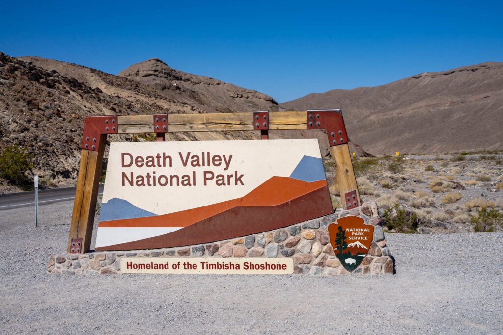
If you were to judge it by its ominous name, you’d probably never want to visit a place called Death Valley . But don’t let the name put you off. For those who like the desert, Death Valley is a fascinating place to visit and one of the few National Parks close to L.A . So, if you decide to tackle the drive from Los Angeles to Death Valley, this post will provide you with an itinerary all the information you need in order to plan your trip.
Table of Contents
How to Drive from Los Angeles to Death Valley
Calico ghost town, vasquez rocks, red rock canyon state park, death valley 2-day itinerary, darwin falls, father crowley overlook, mesquite sand dunes, mosaic canyon, harmony borax works, badwater basin, devil’s golf course, artist’s drive & artist’s palette, the natural bridge, zabriskie point, dante’s view, ubehebe crater, racetrack playa , more than 2 days in death valley, tips for driving in death valley, best time to visit death valley, where to stay in death valley.
The drive from Los Angeles to Death Valley takes about 4.8 – 5 hours, which is why most people visit the park on a weekend trip.

There are two main routes to Death Valley. Both are scenic and both require about the same amount of time.
• The eastern route takes Interstate 10 or 210 to Interstate 15 north to Baker, then California 127 to California 190 west into the park.
• The western route takes Interstate 5 to 210 to California 14, then U.S. 395 to California 190 west into the park.
Depending in which neighborhood you stay in L.A ., you can take one or another. If you are starting from the west side of the metro area (Hollywood, Beverly Hills), or anywhere west of Pasadena, the west approach to Death Valley on Hwy 14 to 395 is the best for you.
One other option is to approach Death Valley from one side and leave from the other. This will give you the possibility to experience both routes.

There may be other ways to drive from L.A. to Death Valley, but my advice is to choose one of the two routes mentioned above. They are not only shorter, but they also offer the possibility of making really interesting stops along the way.

Where to Stop When Driving from Los Angeles to Death Valley
The drive from L.A. to Death Valley passes through some very picturesque areas. You may not be able to stop at each one of them, but here are your options, in case you want to add some extra sites to your Death Valley itinerary.
If you never saw the historic Route 66 before, I suggest to drive a short urban piece of old Route 66 – which is called Foothill Boulevard – as it goes through Claremont and Rancho Cucamonga (30 miles).

Affectionately called the “ Mother Road ,” this 2,400-mile route was the first continuously paved highway linking Chicago and Los Angeles. Driving even a small part of it is a fun experience.
If you have time for a short detour from I-15 you can visit the ghost town of Calico , which is a few miles east of Barstow.

Ghost town devotees may argue that Calico is touristy and over-commercialized, but if you never saw a ghost town before, Calico may be a fun place to visit.
If you drive the western route to Death Valley (via California 14 freeway), between the cities of Santa Clarita and Palmdale you’ll see the big slanted stones of Vasquez Rocks.

If this landscape looks familiar, it’s because Vasquez Rocks have been used as a filming location for many western movies. The park is free to visit. If you decide to stop at Vasquez Rocks, take the Agua Dulce exit from the Fwy 14.
Also on Hwy 14, about 20 miles north of Mojave Desert, is Red Rock Canyon – a small state park along both sides of the highway (not to be mistaken for Red Rock Canyon Natural Preserve in Nevada, west of Las Vegas ).

You can see the rocky walls from the freeway, but if you decide to stop and explore some of the rock formations, you’ll probably need about an hour.
Visiting Death Valley involves a lot of driving, so unless you have a well planned itinerary your 2 days will go by in a flash without being able to see much. In this post I’ll tell you what are the best places to see in Death Valley and how much time you need for each one of them. I will also give you some tips for driving in Death Valley, tell you what is the best time to visit and make some recommendations for the best places to stay while visiting the park.
The points of interested listed below are in the order they come up when you drive to Death Valley from Los Angeles. Seeing them in this order will save you a lot of time. Of course, you may choose to visit some and just skip others, depending on your available time and interests.
Day 1 Itinerary
When you drive to Death Valley from Los Angeles, the first point of interest you’ll come across is Darwin Falls. The falls are located on the west side of the park, about 5-6 miles before the entrance. This is an easy hike that takes a little under an hour to complete.

Darwin Falls is an unexpected oasis in the middle of desert and it’s the only stop on your Death Valley itinerary where you’ll see water.
The dirt road that leads to the falls is lovely and quite short (2.5 miles). It may surprise you to see so much vegetation in the middle of the desert, but places like this are not unique in California. If you hike along the Mojave River, in the San Bernardino Mountains, you will discover another oasis like this at the Deep Hot Springs .
Father Crowley Vista is located 7.5 miles west of Panamint Springs along Highway 190 near the western boundary of the Park. This is a good place to stop and enjoy a panoramic a view into Rainbow Canyon. Time needed: 10-15 minutes.

These are not the tallest dunes in Death Valley, but they are very easy to access (right on Hwy 190, close to Stovepipe Wells). The highest dune (which is about 1 mile from the parking lot) rises only 100 feet. Although not very high, it may still look impressive if you get close enough to it.

You should stop here and take a short hike on the dunes, just for the experience. Walking on sand is a bit of a challenge, so don’t get carried away. Save your energy to walk back to the car. Time needed: 50-60 minutes.
This is a really beautiful hike which we just discovered on our latest visit to Death Valley. The 1.7 miles trail ends at a steep (dry) waterfall. It’s a beautiful canyon, and even though there were some tricky, steep, parts, the hike is not particularly challenging.

We took our time to take photos and made it in and out in 3 hours. But you could easily go faster if you want to.
Harmony Borax Works are the ruins of an old borax ore-processing plant in Furnace Creek Springs. Borax was the “white gold” of the desert, an ingredient used in laundry detergents and in the production of fiberglass.

The 0.4 miles Interpretive Trail shows the remains of a building and a well-preserved 20-mule team wagon (minus the mules). It’s not much to see, but it’s still an interesting stop to add to your Death Valley itinerary. Takes 10-15 minutes to visit.
From Furnace Creek Indian Village continue on Badwater Road to visit the Badwater Basin. This point lies 282 feet below sea level, which is the lowest dry elevation in North America. You can’t really appreciate how vast this salt flat is until you get there and look around. It seems to stretch for miles!

Take a stroll for as long as you want and then turn back. That’s about all you can do in this place. It takes 15-20 minutes to visit, depending on how far you want to walk on the salt flat. Parking is really tight here, but you can also park on the side of the road if there is no space available.
From Badwater Basin turn around and stop at the Devil’s Golf Course, which is just a few miles back on the same road that you came. This area is not particularly spectacular, but it’s worth stopping just to see what strange forms salt can take sometimes.

I can’t think of a more dreadful and inhospitable scenery than the lumpy salt flats at Devil’s Golf Course! It looks really desolate. These formations can be surprisingly sharp, so be careful when stepping on them. You only need 10-15 minutes at the most here.
After Devil’s Golf Course continue to the Artists Palette. Access to the Artist’s Drive is off Badwater Road. The drive itself is 9 miles long and is only one way. That’s why it makes more sense to do it on the way back from the Badwater Basin.

Along the road there are places where you can park your car and hike to see the rock formations. The drive itself takes about 30 minutes, but if you want to hike it may take longer.

The scenery here is absolutely spectacular, so should at leasts to to take pictures. Artist’s Palette was one of the filming locations for the movie Star Wars.
This is a short 1 mile hike (each way) located only 10 minutes away from Badwater Basin.
The Natural Bridge is the perfect spot for a photo-op as you’ll be underneath a stunning 50 foot tall bridge. If you only want to take a few shots, it takes about 10-15 minutes to reach the natural bridge from the parking lot.

The trail is fairly flat, with a minor uphill walk through the canyon. After about a mile you’ll see a large boulder lodged in a narrow part of the canyon. This trail is usually crowded, but is well worth a stop.
Day 2 Itinerary
Your 2nd day itinerary includes some farther away places to drive to in Death Valley. The hardest to reach is Racetrack Playa. If you decide not to drive all the way to it, you should at least go to Ubehebe Crater.
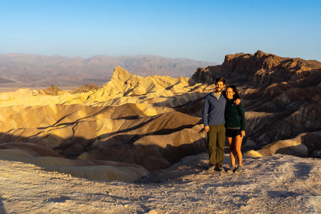
Start your day with a stop at Zabriskie Point, which is located on Highway 190 (about for 4 miles southwest of Furnace Creek.) This is one of the greatest spots for photography in Death Valley, especially at sunrise. As the sun goes up, you’ll witness a truly amazing palette of colors that changes very fast.

The viewing platform is only a short walk from the parking lot. But try to get there early, as the place gets packed with with photographers trying to snap a good shot. Time needed: 15-20 minutes.
From Zabriskie point, continue for another 12 miles on 190 till you reach Dante’s View parking lot. Dante’s Vie is considered one of the most scenic viewpoints over Death Valley. I highly recommend stopping here because you’ll get a great perspective of the entire area, as well as amazing views of the Badwater Basin.

If you only want to take a few shots and admire the valley, you probably won’t spend more than 15 minutes here.
From Dante’s View turn around to go to Ubehebe Crater. The crater is located in the far north end of Death Valley, on a spur road off CA 190, just before the highway turns east and exits the park near Scotty’s Castle.
This is 30-40 miles drive from Furnace Creek, which takes roughly 45 minutes. Although it’s a longer drive, I think it’s worth doing because Ubehebe is one of the most interesting places to visit in Death Valley.

Some people hike down into the crater, but coming back up requires a lot of effort. So if you don’t feel up to it, you can just hike around the crater. Or you can just admire the crater from the platform next to the parking lot. Time needed: 15-20 minutes (if you don’t hike down into the crater).
From Ubehebe Crater you can continue to the Racetrack Playa to see the “Sailing Rocks.” However, keep in mind that this is one of the most difficult places to reach in Death Valley so, if you decide to drive here, you’ll need a 4×4 vehicle with high clearance.

The only way to get there is via a rough, rocky road covered with gravel and sharp rocks, that passes though a very remote area. Flat tires and accidents are very common on this road.
The road is 27-miles long and takes roughly 2.5 hours to drive (one way.) But once you get there, the scenery is absolutely amazing.

Racetrack Playa is a very interesting place to visit, but getting here is a challenge and it’s not for everybody. You’ll have to decide for yourself if you want to put up with all the dust and the difficulty to drive there in order to see the moving stones.
If you have more time to spend in Death Valley, you can expand your itinerary to include some other sites, like the Charcoal Kilns , Scotty’s Castle (temporarily closed now), Grotto Canyon Hike , Eureka Sand Dunes, or Telescope Peak Trail.

- Death Valley is a HUGE park , so expect to do A LOT of driving between the points of interest.
- There are very few gas stations in the Park and the prices are double than anywhere else in California. Even so, fill up your tank whenever you come across a gas pump.
- There is no GPS or cellular service in Death Valley, so we recommend bringing a map with you.
- We recommend buying a good Death Valley Map , since the ones provided by the Visitors Center are very sketchy.
- Internet is unusable in Death Valley. Some hotels offer free WiFi, but the signal is too weak.
- Entrance Fee for the Park is $30/vehicle (valid for 7 days) and can be paid at any of the park entrances or pay stations.
Death Valley is one of the most popular National Park in the United States and it’s open year round. However, by May the valley is too hot for most visitors. Nonetheless, you’ll see people flocking to the park all throughout the hot months of Sumer.
Spring is the most popular season in Death Valley, with temperatures between 75-90ºF. This is the beat time of year to see wild flowers, if California received enough rain the winter before.
By May the valley is already too hot for hiking, yet all throughout the summer, visitors from around the world still flock to the park in the hope of catching a glimpse of its beautiful sites. Summer temperatures are between 110-116ºF.
Fall arrives in late October in Death Valley. The temperatures start cooling off considerably and it’s time again for hiking the canyons and visiting the sites. Temperatures vary between 93-55ºF.
Winter has cool days and chilly nights, with some snow on the high mountains. Average temperatures are between 40-60ºF. This period is particularly beautiful for exploring the valley.

There aren’t many lodging options in Death Valley, so expect to pay a lot if you want to stay the park (between $370-$580/night). The only hotels available are: the Ranch at Death Valley, the Inn at Death Valley, and Stovepipe Wells Village.
The first time we came from Los Angeles to Death Valley we stayed at Amargosa Opera House Hotel, at the Death Valley Junction. This is a modest hotel, but with a very interesting history. Even if you don’t stay there, the hotel it’s worth visiting for its strange Spanish style Opera House, dating back to 1923. So if you have more than 2 days in Death Valley, I suggest adding this to your itinerary.

This time we stayed at the Inn at Death Valley and we were very pleased with the level of comfort. Unfortunately, prices were through the roof, but we paid for the convenience of staying in the park and be close to all the attractions.
The hotel has a first class restaurant on the premises, a bar, a large swimming pool, a huge terrace, and a beautiful green park with a pond.
If you found this information useful, please pin it for later :

YOU MAY ALSO LIKE:
- 17 Incredibly Interesting Things to See in Death Valley
- 8 Amazingly Beautiful National & State Parks Near Las Vegas, Nevada
- Interesting Facts About Los Angeles That Not Even Angelenos May Know
- The Ultimate Guide to Visiting the Vasquez Rocks
Anda is an award winning travel writer, avid globetrotter and passionate photographer. She is the voice behind "Travel Notes & Beyond," a collection of stories and travel impressions from her wanderings around the world. When she is not busy writing, traveling, or editing photographs, you can find her hiking in the foothills behind her house together with her husband and their dog.

Reader Interactions
December 27, 2023 at 10:57 am
Thanks for the informations! My Tip to stay: Town of Beatty. It’s not that far and the prices are more than okay. I stayed two times in the Death Valley Inn. Next year I try the Exchange Club Motel.
Rhonda Albom
April 21, 2022 at 2:19 pm
There are a lot of fascinating sites between LA and Death Valley that I never knew existed, even though I thought I had driven so much of the state when I lived there. I went from Death Valley to San Francisco and La to Joshua Tree. Now I want to drive again, following your route and definitely stopping at the Mosaic Canyon.
April 21, 2022 at 6:39 pm
I need to come to New Zealand and you need to come to California more often, Rhonda.
Leave a Reply Cancel reply
Your email address will not be published. Required fields are marked *
Save my name, email, and website in this browser for the next time I comment.
COPYRIGHT NOTICE
All rights reserved © Travel Notes & Beyond. The material on this website is protected by copyright law. Republishing the content on this blog (including text, photography, etc.) is strictly prohibited.

AFFILIATE PROGRAM DISCLOSURE
Some of the pages and posts of this blog contain links to products and services that may be useful for my readers. When clicking on these links you will have the option to purchase or register for a service at no extra cost to you, but doing so can help me offset the costs associated with running this blog. Thank you for your support!
Home > Road Trip Itineraries > West Coast > California Road Trip Itineraries > Southern California Road Trip > Los Angeles to Death Valley: Recommended Itinerary and Possible Stops along the Way

Los Angeles to Death Valley: Recommended Itinerary and Possible Stops along the Way
This site may contain affiliate links. We may receive a commission for purchases made through these links.
Death Valley is one of the most intriguing national parks in the American Southwest , as well as the largest in the contiguous United States. Although it is located in California , the closest major city is Las Vegas , Nevada . It is no coincidence that most of the organized tours to visit this area depart from this city. However, if you are planning a road trip to California or an itinerary that includes several states, you might be wondering if it is possible to cover the distance between Los Angeles and Death Valley . Out of all the major cities in California, in fact, LA is the closest and the best connected. It’s worth dedicating an article to this route for a very simple reason. These two places are part of many routes that cross the Southwest, but they are many miles apart. So let’s see how to best organize your trip , and perhaps how to include some stops to see other natural attractions or special places.
From Los Angeles to Death Valley: Driving Distance and the Best Route
Vasquez rocks, red rock canyon state park, trona pinnacles, ballarat ghost town, where to stay between los angeles and death valley, route map los angeles – death valley.

Over 400 miles separate Los Angeles from Death Valley, and as you can imagine, there is not just one way to get to the park from the coastal city. There are two main routes:
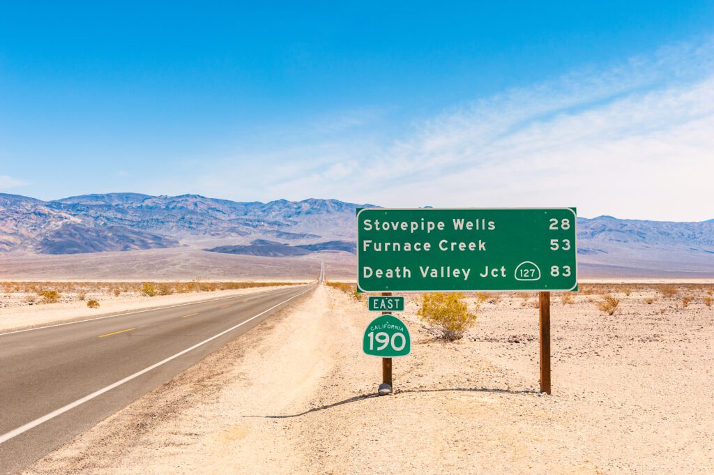
- The first option ( about 286 miles for a 4 hour and 15-minute trip ), is to drive on CA-14 north to Cantil, where you will take Redrock Randsburg Rd to reach 395 and from there (taking a shortcut on Searles Station Cutoff), CA-178, and then CA-190 to Death Valley.
- The second option ( about 298 miles for 4 hours and 30 minutes of travel ), is to go on US-10 towards San Bernardino and then turn on US-15. Stay on US-15 until you get to Baker, where you will take CA-127, which will lead you to Death Valley Junction and then to CA-190 until the entrance of the park.
Consider that it is best to visit Death Valley early in the morning , especially in the summer, when the heat can be really unbearable in the middle of the day. Moreover, this is a park that requires you to spend a lot of time driving even to visit it, having to drive several miles through it. Therefore, it may be worth not visiting the park on the same day you drive from Los Angeles. My advice is to choose the first of the two routes mentioned above, not just because of the shorter duration, but also, and above all, because it gives you the possibility of making really interesting stops along the way . In this way, you can use the day not only to drive but also to enjoy some other beautiful places in California. You will stay overnight near Death Valley in order to visit it the next morning.
Los Angeles to Death Valley Itinerary: Best Places to Visit
If you leave Los Angeles in the morning and plan to spend the night near Death Valley, you can either visit a minor park , or make short stops in some unique places. The same is obviously true if you head in the opposite direction towards Los Angeles. If you are particularly attracted by the places I suggest below, you could also consider dedicating an extra day to them, and spend the night to break up the trip.

If you’re a fan of Star Trek , but even if you’ve never seen it, the landscape of the Vasquez Rocks will look familiar to you. This was one of the sets of the famous science fiction saga, but also of other Hollywood movies. Located just 40 minutes from the city , without needing to take long detours from your route, you can make a stop at this park where natural beauty goes hand in hand with curiosities and pop culture attractions, in this case, movie sets. In our article about Vasquez Rocks , you can find out why it’s worth stopping here and how to reach the park from Los Angeles. The detour from CA-14 to reach Vasquez Rocks is short and admission is free. So, even if you are undecided, ask yourself: Why not ?

Red Rock Canyon is a fairly common name, so be careful not to get confused! The most famous red rock canyon is Nevada’s Red Rock Canyon , but there are others scattered throughout the Southwest. On the other hand, we’re in a geographic area known for both red rocks and canyons. In any case, although it may be smaller and certainly not as famous as others, this canyon is worth visiting, especially if you are passing through. The fastest way to travel between Las Vegas and Death Valley is to get off of CA-14 at some point and get on Redrock Randsburg Rd.
Here, if you do not leave the main road at this point, after 5 minutes you will come across the Red Rock Canyon State Park (California) and you’ll find directions to its Visitor Center. The entrance fee is $6 per vehicle and you may decide, depending on the time you have available, to wear a pair of comfortable shoes and walk the trails of the park. A couple of hours are enough for a substantial visit to this park, which can easily be inserted in the itinerary between Los Angeles and Death Valley .
In our article about Red Rock Canyon State Park , you will find all the details to organize your visit , which can help you decide, when considering all the stops along the way, whether or not this one is for you.

Not far from the town of Ridgecrest, Trona Pinnacles , one of the hidden gems of California , rise from the desert terrain soaring into the sky, giving the area a sci-fi atmosphere. This small natural wonder is a stop to seriously consider along this itinerary because the detour is short and well worth it.
You’ll probably feel like you’re walking on an asteroid, and you won’t be the first to think so! Many science fiction movies have been filmed here because of the setting, which resembles a desert planet lost in space. The last part of the road is unpaved , but you can still drive on it without any issues by paying attention and going slowly. The directions to reach Trona Pinnacles from Ridgecrest, as well as details on these strange pinnacles made of tufa, can be found in our article about Trona Pinnacles .

Please note: Trona Pinnacles can be reached on the way to Death Valley not just from Los Angeles, but also from San Diego , or other parts of Southern California!

If you’re a seasoned traveler along America’s most remote roads, you’ve certainly crossed a few ghost towns. If, on the other hand, you haven’t yet, you should know that there are numerous ghost towns that are also very different from each other. There are some very touristy ones, but also others so remote and creepy as to give rise to the suspicion of being seriously inhabited by ghosts .
About 50 miles north of Ridgecrest, you can take a small detour from the Death Valley itinerary and reach Ballarat. Despite the swirls of desert dust, creepy creaking sounds, and legends of a serial killer, this place is not entirely uninhabited. In fact, Rock Novak is the only inhabitant and performs the functions of mayor, doctor, judge, sheriff, priest, and… gravedigger, although one wonders how he could bury himself since he is the only mortal citizen among the many ghosts of Ballarat. To get there, just go north on CA-178 . Half an hour past Pioneer Point, look for a small green sign on the right for Ballarat Rd.

The basic plan of this itinerary is to leave in the morning from Los Angeles, stop in one or more of the recommended stops, arrive in the evening near Death Valley, and visit the park the next morning. So my first suggestion is to look for a hotel near (or even inside!) Death Valley .
Our recommendations for accommodations near or in Death Valley
However, if you are considering an overnight stay along the way, to see more of the attractions along this route, my suggestion is to look for a hotel in Ridgecrest . It is located 45 minutes from the Trona Pinnacles , an hour from Ballarat, and an hour and twenty minutes from Red Rock Canyon . Ridgecrest is an ideal central location that is convenient for any of the proposed stops.
All accommodations in Ridgecrest
A third option is Mojave , located between Vasquez Rocks and Red Rock Canyon. I recommend it especially if you are planning to leave Los Angeles in the afternoon (it is an hour and a half drive away), and to see Vasquez Rocks that same afternoon, and then access Red Rock Canyon the following morning. Alternatively, if you are planning the itinerary in the reverse direction and looking for lodging after visiting Red Rock Canyon, this is also a good option.
All accommodations in Mojave
Warning: Operating hours can change and closures for extraordinary events can occur, so we strongly suggest to check the venues official websites.

Andrea Cuminatto
Journalist and traveler. I love seeing new places, but more than anything, I love to meet those who live there.
Related posts
Leave a comment cancel reply.
This site uses Akismet to reduce spam. Learn how your comment data is processed .

Road Trip from Los Angeles to Death Valley National Park
This epic Californian road trip takes you from sunny, buzzing Los Angeles, to the incredible landscapes of Death Valley National Valley, traveling past amazing scenery and fascinating landmarks along the way. If you are looking for the perfect long weekend getaway, this is it!
The 320-mile trip from Los Angeles to Death Valley National Park takes about 6 hours, via highlights Santa Clarita, Bakersfield, Searles Valley, Las Vegas, San Bernardino, Palm Springs, Barstow and Red Rock Canyon National Conservation Area.
This breathtaking and interesting journey is sure to leave a lasting impression, and that's before even reaching the unique and awe-inspiring landscapes of Death Valley National Park. Keep reading to see where we suggest stopping off and exploring en route.
How far is Death Valley National Park from Los Angeles, and how long will the road trip take?
The very scenic Bakersfield Route takes about 5 hours and 35 minutes to travel 320 miles if you are taking no detours along the way.
Travel the alternative Las Vegas Detour journey and you will be traveling around 8 hours, passing 500 miles on this beautiful route.
Both of these road trips are fairly short and could just about be completed in daytime driving, however we suggest taking 2-3 days to make the most of all the incredible sights you can explore and enjoy on the way.

Best road trip route from Los Angeles to Death Valley National Park
As you pass through the ‘Golden State' of California towards Death Valley National Park both of the routes that we suggest will take you on an incredibly scenic and very exciting journey.
The best route will ultimately depend on how much time you have, what you'd like to see and where you'd like to visit on this epic adventure.
The Bakersfield Route is a thrilling, fun and picturesque road trip that includes beautiful and unusual landscapes and cultural hot spots. You'll get a chance to ride rollercoasters, explore historical sites and hike across beautiful parkland.
If you are a fan of the Fast and Furious movie franchise, you might recognize parts of this route as you will get to briefly drive on Highway 58, which is potentially where the famous escape race was filmed.
Take the Las Vegas Detour and this beautiful scenic road trip visits some of the most impressive national parks, balanced with memorable city sights. You can be sure a detour to Las Vegas is never going to be short of surprises!
How to drive from Los Angeles to Death Valley National Park
The map above shows our suggestions for the best road trip routes between Los Angeles and Death Valley National Park. Keep reading for detailed descriptions of both routes, where to stay on either, and the best things to do on the way.
The Bakersfield Route
From Los Angeles take Insterstate-5 (I-5) towards Santa Clarita, where you can enjoy a rollercoaster or two at Six Flags Magic Mountain, before rejoining the I-5 and for scenic stop offs at Castaic Lake State Recreation Area and Frazier Park ahead of Bakersfield.

Settle for a night or two in Bakersfield where you can take in the Museum of Art and Downtown Arts District to admire local talent and art installations. Afterwards pick up CA-58 East to continue on this journey.
Stop off at the Tehachapi Heritage League Museum to learn more about the area's history, before arriving at iconic Kramer Junction to pick up food and gas, then take US-395 for the final leg of this trip.
Make sure to visit Searles Valley and the unusual Trona Pinnacles landmark, dotted with hundreds of tufa spires, before arriving in the stunning Death Valley National Park to continue an incredible and exciting trip.
The Las Vegas Detour
Taking the Las Vegas Detour starts by leaving Los Angeles along the I-10 East, taking in San Bernardino National Forest, with its incredible mountain scenery. A unique stop at the Original McDonalds Site and Museum can also be seen!

Continue along I-10 and you'll arrive in beautiful Palm Springs, then continue along CA-68 for wildlife spotting in Desert Hot Springs, before taking the CA-247 to marvel at religious sculptures dotted around Desert Christ Park.
Keep driving along CA-247 where a stop at Barstow will give you the chance for some history and ghost tours at Calico Ghost Towers, before traveling I-15 through the beautiful Mojave National Preserve and Sloan Canyon National Conservation Area.
A change of pace with an arrival at Paradise, and shortly after Las Vegas, gives the chance to tick off some bucket-list sights in Las Vegas including the iconic Strip, entertainment, and a visit to the replica of Grand Canal in Venice.
After a night or two in Vegas the beautiful scenery of Red Rock Canyon National Conservation Area awaits you, before taking the US-95 towards end destination Death Valley National Park.
Best places to stop between Los Angeles and Death Valley National Park
These beautiful road trips pass some of California's most scenic inland landscapes and make for a journey packed with amazing things to do and unforgettable sights to enjoy.
We recommend stopping overnight to make the most of these routes, so keep reading to see whereabouts we suggest you should hang out a little longer.
Take in a show at Bakersfield
Head along the Bakersfield Route on this road trip from Los Angeles to Death Valley National Park, and there is no better place to stopover than Bakersfield itself, found around halfway along this route.
Make sure to head to the California Living Museum first to check out the museum, rides, and over 200 animals. This diverse attraction is particularly popular in the holiday season, where there are amazing illuminations too.

To understand more about the area, visit Kern County Museum. The Western buildings are interesting to stroll round, depicting past life of Kern County along with impressive landmarks such as Beale Memorial Clock Tower.
Afterwards visit Fox Theater, an iconic theater in the heart of Bakersfield. There are plenty of shows taking place here each day, so check out a film or show at this famous arts and community center.
We recommend stopping over in the Padre Hotel , which is set in the heart of Bakersfield and on the doorstep of so many top attractions including Buena Vista Museum of Natural History and Centennial Plaza.
This four-star hotel enjoys modern décor, with gorgeously designed lounges and bar. Make sure to head to the rooftop Prairie Fire to enjoy drinks with views over the city, before dining at on-site Brimstone Bar. Delicious.
Marvel at the bright lights of Sin City
Around two hours from your final destination in Death Valley, this change-of-pace and bucket-list stop off Las Vegas is a memorable sight to enjoy before arriving at Death Valley National Park.
Wander the four-mile stretch of The Strip, buzzing with entertainment, bright lights and places to enjoy all day and all night. The Grand Canal is just one of these amazing sights. A replica of Venice, head here for a spot of shopping and browse from the comfort of your very own gondola.

Make sure to visit Bellagio Botanical Gardens and Fountains. The impressive gardens and displays are adapted year-round, and the fountain waters play a complex choreography unlike anywhere else. Sit back and enjoy the show.
For a change of scene visit the Las Vegas Arts District. Spread over 18 blocks, it is teeming with interesting and artistic displays, artworks and shops.
For a hotel that matches the energy of Sin City then look no further than Wynn Las Vegas . Set in an amazing location, close to all the great sights of Las Vegas, it is super close to sights such as Eiffel Tower at Paris Hotel, Bellagio Conservatory and Botanical Gardens and Las Vegas Festival Grounds.
This hotel houses three incredible on-site pools, a spa, designer shops, and a state-of-art fitness center for a yoga class or massage.
An impressive concierge service is also on hand to supply you with all the information on the top places to visit during your stay, but with 15 restaurants on-site you won't need to travel far for amazing hospitality.
READ MORE - Click here for more great hotel options
Where to stay when you reach Death Valley National Park
The incredible and diverse landscape of Death Valley National Park is breathtaking, with the Mesquite Flat Sand Dunes and Badwater Basin just some of the amazing sights here.
To match this incredible experience, stay at a beautiful five-star hotel, nestled within Death Valley National Park itself, The Inn at Death Valley .
The stunning property boasts a beautiful outdoor pool to relax in after a busy day exploring, with a gorgeous terrace to relax on and take in the views.
Enjoy a night or two in the beautiful, lush, lodge-style rooms and lounges, with plenty going on to enjoy including golf and cycling. Hungry? Then you can choose from two great restaurants on-site, serving delicious American cuisine.
Things to see on a road trip from Los Angeles to Death Valley National Park
Take this pretty road trip from Los Angeles to Death Valley National Park, and although it is short it is also very sweet indeed, full of beautiful landscapes, historical and cultural landmarks, and unique sites to explore. Keep reading to see our list of things to see and do along the way.
- Santa Clarita - Ride the thrills and spills of Six Flags Magic Mountain, spread over 262 acres this amusement park is sure to keep you entertained.
- Castaic Lake State Recreation Area - There are over 11,000 acres to explore, with parklands and a state park reservoir, the largest in Southern California. The 425-foot Dam is particularly impressive.
- Frazier Park - Pretty park to stop at for a leg stretch, with expansive grounds and lake to enjoy.
- Bakersfield - Known for its art and culture scene make sure to visit the Bakersfield Museum of Art and Downtown Arts District to admire local talent and art installations.
- Tehachapi Heritage League Museum - Founded in 1973, this museum is dedicated to informing its visitors about the area's history, whose past began in the area with the arrival of the Kawaiisu over 1,500 years ago.
- Kramer Junction - This recognized junction, also known as ‘Four Corners' gives you the option to head in each direction to continue your journey. A good place to stock up on food and gas.
- Searles Valley - The valley and lake beds here were formed by the evaporation of the water thousands of years ago. A unique attraction.
- Trona Pinnacles - Found in Searles Valley, this area is made up of 500 tufa spires dotted across the landscape. An unusual and interesting stop-off.

- San Bernardino National Forest - The incredible mountain scenery is breathtaking. You get amazing views whether driving or hiking, or how about taking to horseback across the trails of this 23,000-acre site.
- Original McDonalds Site and Museum - A great museum in San Bernardino for any burger fans, this iconic building will tell you everything you need to know about McDonalds, its history and legacy.
- Palm Springs - Explore this beautiful area by taking a hike across the Indian Canyons to see the area at its best, and interesting native plants and landscape.
- Desert Hot Springs - Hike across the Hidden Horseshoe and Pushawalla Palms Trail, where you pass plenty of wildlife living amongst the sand dunes and palms.
- Desert Christ Park - Found near Flamingo Heights, this interesting garden in Yucca Valley is dotted with religious sculptures crafted by Antone Martin. There are over 40 on display.
- Calico Ghost Towers - Just outside Barstow this event runs every Saturday, where you can tour the historic town and maybe experience some paranormal activity.
- Mojave National Preserve - Over 1.5 million beautiful acres, and home to more Joshua Trees than anywhere else. The Hole-in-the-wall trail is a popular hike to get great views.
- Sloan Canyon National Conservation Area - Spread over 48,000 acres, this area is packed with geological interest points, with hundreds of rock carvings dating back to natives thousands of years before.
- Paradise - Adjacent to Las Vegas, this town is brimming with museums and interesting attractions. How about heading to the unusual National Atomic Testing Museum?
- Las Vegas - Wander in awe along the impressive Strip, spanning miles with places to eat, drink and be very merry. This once-in-a-lifetime city has to be seen to be believed.
- Red Rock Canyon National Conservation Area - A visit to this National Park around 20 minutes from Las Vegas is a must-see. Take a guided tour to best see the red rock formations and amazing views. You might need to make a reservation for a timed-entry slot, so check the official website before traveling.

Best time to go on a road trip from Los Angeles to Death Valley National Park
Spanning over three million acres there is plenty to see and do when you arrive at Death Valley, which offers a lot year-round with changing scenery depending on when you visit.
However, with the peak summer scorching, we recommend visiting outside of this time of year to be able to best explore this amazing national park and not have to cope with temperatures reaching up to 116 degrees Fahrenheit.

If summer is the time you are set on visiting, then making the trip very early in the morning or later in the day is wise to keep the temperatures at bay. Make sure to pack plenty of water and refreshments and seek shade when you can.
If you travel during winter, then the desert heat can be avoided and temperatures in the day still range from around 40 degrees to 55 degrees Fahrenheit. However, evenings can drop to freezing so pack plenty of layers.
Spring or fall are also great options to visit this impressive park, where you miss the extreme heat, and cold, and the attractions are typically quieter, and local places to stay are likely to have better deals on for staying.
Spring in particular is a popular time to visit with the beautiful wildflowers emerging. These flowers transform the otherwise dusty landscape and really are a mesmerizing addition to your experience of this amazing national park.
Join our email list!
By joining our email list, you give LazyTrips permission to use your email for sending you newsletters, emails and updates including for marketing purposes. Your email will not be provided to third parties.
Related posts

Discover Which Colorado Mountain Town is right for you
Your Utterly Scenic Death Valley Itinerary
- December 3, 2020
- By foxintheforest
Last Updated on January 15, 2024 by foxintheforest
As the largest national park in the Lower 48, Death Valley has a lot to offer. Eerie rock formations and ever-expanding salt flats feel other-worldly. Make the most of your visit with this Death Valley itinerary designed to bring you the most beautiful scenes in Death Valley.
Taking a Death Valley Road Trip – long or short – is definitely a beautiful experience. Don’t let the name fool you – this place has plenty of life. In fact, it’s real name is “Tumpisa” or “land of the red paint rock.”
I’ve been all over the country, and Death Valley truly surprised me. It’s vast, dramatic landscape brings a beauty that’s hard to describe. Even photos don’t really do the place justice.
About this Mega-Epic Death Valley Itinerary
Okay, so as a full-time outdoor writer, I’ve become an expert at making the most of your time outdoors. This stunning Death Valley itinerary features:
- Info on when to visit Death Valley National Park
- How many days to spend exploring the park
- Accessing the park and how to plan a Death Valley road trip
- A comprehensive Death Valley itinerary featuring one day in Death Valley and additional days.
- Camping and places to stay
- Tips for visiting Death Valley
- Additional planning resources
When to Visit Death Valley
One of the great things about Death Valley is the ability to visit the park year-round and still be able to see (most) main attractions.
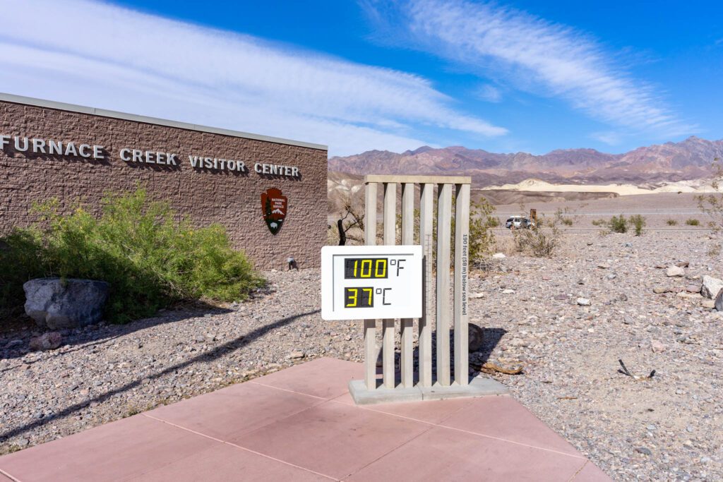
Remember, Furnace Creek – inside the park – is the HOTTEST place in the country. I’m talking melt-your-skin-off 130-degree temps. SCORCHER.
Therefore it’s best to visit Death Valley between October and April. Fall sees less crowds. Winter is best for camping and hiking. While spring is busy with wildflower viewers.
Summer is possible, but come prepared! Lots of sunscreen, long-sleeve UPF clothing, plenty of water and electrolytes, and a robust vehicle with aircon.
How Many Days Should I Spend in Death Valley?
There are several unique ways to go on a Death Valley road trip, however most Death Valley itineraries are a maximum of 3 days.
If you only have one day in Death Valley, you can easily see many of the big highlights.
Since some of the other must-see attractions are so spread out, two days is a perfect amount of time to spend in Death Valley.
For those that don’t want to feel rushed – or have a particular interest in mining history – three days is perfect.
Pro Tip : It’s $30 to enter Death Valley National Park or free with an America the Beautiful Parks Pass.
Going on a Death Valley Road Trip
Alright, so if you’ve looked on a map, you’ll see that Death Valley is kind of…out there. In fact, it feels like the middle of nowhere. This certainly adds to the mistique of the park.
There are two main ways to go on a Death Valley road trip. Head from the east or west side of the park.
From Las Vegas
Death Valley is one of the best day trips from Las Vegas. If you’re arriving from Las Vegas, the easiest way to access Death Valley is to head east on US 95, then head south State Road 160.
You’ll pass through Pahrump, a small town that’s perfect for mid-priced lodging (and cheap gas). Fill up on gas here before heading out on your Death Valley itinerary.
From Los Angeles
The fastest way to get to Death Valley from LA is to head past Barstow on I-15 and swing northeast around the park. You’ll pass Death Valley Junction – an odd ghost town.
Alternatively, you can access the park from the west side via Panamint Springs. This is your best option if you want to create a Death Valley road trip that includes stops like Alabama Hills, the Sequoia National Forest and other awesome places in California.
Death Valley Itinerary Day 1
First, stop at one of the pay stations near Furnace Creek (or others). It’s $30 for 7 days in the park. Other fee stations include:
- Stovepipe Wells Ranger Station
- Grapevine Ranger Station
- Zabriskie Point
- Hell’s Gate
- Campgrounds in the park

See the Drama of Death Valley at Dante’s View
Your first stop takes you to 5,476 feet above sea level. Dante’s View is hands-down one of the best things to see in Death Valley.
This mega-stunning viewpoint shows you just how vast (and tall) Death Valley really is. The elevation difference between the highest point – Telescope Peak – and the lowest point – Badwater Basin – is over 11,000 feet.
If you can make it here for sunset, ah-mazing! If not, the views are still stellar all day.
Pro tip: Bring a jacket, it’s actually chilly up here!
Distance from Furnace Creek: 24 miles, 40 minutes
Scope Out the Sand Flats at Badwater Basin
After you’ve soaked up the most of the panorama at Dante’s View, you’re going down. Way down.
Badwater Basin is the lowest point in the US at -282 feet below the sea. The salt leeches from below the ground and creates stunning crystal formations. With the salt comes the moisture. The ground is surprisingly wet just below the salt crust. There are even lakes here.
Take your time and explore, but be aware of the heat. This stop is best at the beginning of the day before the crowds show up and the sun becomes too oppressive.
There are toilets here too, so take advantage if you need the facilities.
Pro tip: This place sucks the life out of you quickly. Salt pans dry out your skin and reflect the sun’s rays. Bring sunscreen, wear proper footwear, and don’t wander too far if it’s hot.
Distance from Dante’s View: 41 miles, 1 hour.

Hike the Natural Bridge
This short trail is only 2 miles round-trip and is an easy hike if the temperatures are cooler.
You’ll spot a stunning natural bridge and see just how uniquely strange the rock is here. It’s almost as if it will crumble at any moment, but at the same time, the clay-like soil is very unforgiving.
If you’ve seen the best of the American Southwest, this is a ho-hum hike (scope out Golden Canyon instead). However, if you’ve never seen a natural bridge before, it certainly has a wow-factor!
Pro Tip: If you’re visiting during the warmer months (April through October) hike the Natural Bridge after Dante’s View. Then head to the Devil’s Golf course for a delicious lunch. Afterwards, peep Badwater basin before continuing with the rest of this Death Valley itinerary.
Distance from Badwater Basin: 5 miles, 10 minutes
Pack a Picnic Lunch at the Devil’s Golf Course
For a whacky and weird lunch spot, take the dirt road to the Devil’s Golf Course. Signs on Badwater Road guide the way (you’ll pass it if you’re coming from Dante’s View to Badwater).
Here you’ll be able to see just how much upheavel and movement the floods, salt, and water cause. Sometimes salt formations form that look like golf balls (or eggs) which is where the spot got it’s name.
Plan for a picnic lunch in your vehicle (if it’s hot) or pop the trunk and sit facing this strange landscape. Don’t forget to pack out all of your trash.
Pro tip: The terrain here is unforgiving. It’s easy to trip and fall so take care.
Distance from Natural Bridge Trailhead: 12 miles, 17 minutes
Drive to the Painted Hills of Artist’s Pallet
One of the highlights of one day in Death Valley has to be Artist’s Drive. These gorgeous hills appear to be brushed by an artist with their vibrant greens, purples, and yellows.
The colors come from various minerals and elements in the rock. Half way through the drive you’ll reach Artist’s Pallet. This pull out gets you up close and personal to these stunning hillsides.
You can walk around and explore a little to really admire the view. Also, this is a great spot for a toilet break.
The one-way loop drive through these stunning hills is a must-do on any Death Valley itinerary. Honestly, I thought it was a highlight of the park. Take your time and use the little dirt pullouts to explore this area further (and without crowds).
Pro Tip: The colors are at their brightest when the sun is at its highest. Visit during the middle of the day for the best color.
Distance from Devil’s Golf Course: 10 miles, 20 minutes

Catch a Sunset at Zabriskie Point
By this point, you may be tuckered out (or the sun may be heading to bed). If you’ve got time, check out the “More Options” section for nearby attractions to add to your Death Valley itinerary.
If not, then round out your day with a sunset at Zabriskie Point. Watch as the sun lowers over the horizon and the golden hills come to life with playful shadows. This easy overlook has benches and a few nearby hills to explore.
Distance from Artist’s Drive: 13 miles, 22 minutes
If you’re only spending one day in Death Valley then now is the time to head back. Or, you can opt to stay until the sky grows dark and check out the stars!

Stargazing in Death Valley
Death Valley National Park lies in one of the few Dark Sky Territories left in the US. This means that there is no light polution to obstruct your nightime view.
One of the most amazing parts of any multi-day Death Valley itinerary is stargazing. A few of the most incredible spots to see the stars is:
- Dante’s View
- Harmony Borax Works
- Badwater Basin
- Mesquite Flat Sand Dunes
More Options for One Day in Death Valley
If you’re quick to see the sights, you can scope out these additional nearby attractions in this section of Death Valley National Park:
- Twenty Mule Team Canyon : Short scenic drive with short hiking opportunities. Near Zabriskie Point.
- Golden Canyon: 4.4-mile scenic loop hike (Gower Gulch) great for sunset. Near Artist’s Drive. Could do instead of Natural Bridge.
- Furnace Creek Visitor Center: Learn about the unique history and geology of this magical location. Closed in 2020.
Where to Stay in Death Valley
There are not too many options when it comes to where to stay in Death Valley. In fact, there are only a couple of (expensive) lodging options inside the park.
- Stovepipe Wells Hotel
- The Inn at Furnace Creek
- The Ranch at Furnace Creek
- Panamint Springs Resort
For lodging outside the park, check out the towns of Beatty, Nevada in the north or Pahrump towards the south end of the park. Both towns offer mid-range lodging that’s cheaper than staying inside Death Valley.
Death Valley Camping
If you’re keen to camp in the desert, then reserve a spot (or use a first-come-first-served campground) inside Death Valley National Park. Camping is closed during the summer months. You’ll find 9 campgrounds in the park:
- Furnace Creek: Reservations. Open year-round (summer not recommended).
- Sunset at Furnace Creek : first-come-first-served
- Texas Spring at Furnace Creek : first-come-first-served
- Stovepipe Wells : first-come-first-served
- Mesquite Spring : first-come-first-served
- Emigrant: first-come-first-served. Tent only.
- Wildrose : first-come-first-served
- Thorndike : first-come-first-served. 4WD required.
- Mahogany Flat : first-come-first-served. 4WD required.
Death Valley Road Trip Day 2
Risse and shine! It’s time for day 2 of this Death Valley itinerary. Today you’ll be exploring the northern end of the park. With plenty of beautiful sites and mining history, there’s a lot to see.
Wonder About the Stones at the Racetrack Playa
Start your day early and head toward one of Death Valley’s more remote attractions, Racetrack Playa. It’s a bumpy ride, but worth it to check out this unique place.
The first thing you’ll notice are the rocks that seem to 1) come from nowhere and 2) move. Yup. That’s right. These rocks travel (you can tell from the depression of mud behind them).
Scientists are still stumped by this phenomena. Please don’t move the rocks, or step on their unique trails across the badlands.
Pro Tip: This place is far out of the way. You’ll need a 4×4 vehicle to make this bumpy journey.
Distance from Furnace Creek: 83 miles, 3 hours

Hike the Ubehebe Crater
After you’ve solved the mystery of the traveling rocks, head to the Ubehebe Crater. The drive through the badlands is quite pleseant and there’s plenty to see at this massive crater.
Opt to walk down and back out of the crater (remember you’ll be going uphill in the heat on the way back). Alternatively you can circumnavigate the crater and check out the views nearby. Option 2 is my favorite, since you’ll have the best views.
Pro Tip: This is a great lunch spot too!
Distance from Racetrack Playa: 27 miles, 1 hour and 50 minutes.
Scour the Mesquite Sand Dunes
After a filling lunch, it’s time to see the most beautiful sand dunes in Death Valley. The Mesquite Sand Dunes are one of four dunes in the park, and the easiest to access.
Climb the dunes and sled down (a popular activity) or relax and soak in the views. The Mesquite Sand Dunes deliver some of the most incredible views in the park.
It’s easy to spend a few hours here, so take your time to explore or come back later in the evening.
Distance from Ubehebe Crater: 45 miles, 1 hour.

Additional Activities for Day 2 of this Death Valley Itinerary
If you’re a fast visitor or you’ve got extra days in your Death Valley Itinerary, these northern attracations are woth a look:
- Stovepipe Wells : Old town and mining community
- Harmony Borax Works: Mining operation.
- Grotto Canyon Hike : A technical, scrambly, 2-mile hike that offers a little shade and a lot of challenges
- Telescope Peak Trail: A challenging 14-mile hike that lets you see both the highest (Mt Whitney, 14,505 feet) and lowest (Badwater Basin (-282 feet) in the contiguous US.
- Aguereberry Point : A stunning viewpoint that requires a 4×4 vehicle. The views are better than Dante’s.
Tips for Visiting Death Valley
Before you head out on a Death Valley road trip, keep these tips in mind:
- The park is HUGE! Driving distances are vast and gas is hard to come by. Fuel up before you come in and take your time – the drives are wonderful.
- Bring plenty of water, shade, and salty snacks. There really aren’t any fascilities in the park (unless you want to grossly over-pay) so come prepared.
- Start early and head out in the evenings. If you’re hear during the hot months, definitely avoid the heat of the day, it’s oppressive.
- Cell service is mostly non-existant. Download offline maps with Google Maps before you head out, or pick up a National Geographic map of the area.
Come see one of the most unique places in America with this Death Valley itinerary. You’ll hit the highlights and feel like you’ve really gotten a flavor for the park.
Honestly, this place truly wowed me, and I’ve seen some amazing places. It’s worth it to at least spend one day in Death Valley to see what all the excitement is about.
Additional Death Valley Road Trip Resources
Planning a trip to Death Valley? Here are a few handy resources for nearby attractions:
- What to See in Red Rock Canyon
- The Most Challenging Hikes in California

Meg Atteberry
Meg is a long-time Colorado local and outdoor industry professional. She's spent the last 15 years hiking, climbing, mountaineering, and canyoneering all over Colorado, Utah, Arizona, and Nevada in search of the best views. She's written for Outside Magazine, REI, Backpacker Magazine, and appeared on the Weather Channel.
Let’s connect!

Meg aka Fox is a 30-something who's born to explore. Toddler mom, queer, and neuro-spicy her favorite things to do are climb in the alpine and camp in the desert. Her mission is to get you out on your greatest adventure.

Ultimate Death Valley Road Trip: A 5-Day Itinerary from LA

Death Valley has been on my bucket list for a long time, so I was very excited when I was presented with the opportunity to road trip from LA to Death Valley thanks to my friends at Visit California. You can use their Road Trip Finder search tool to plan your own epic road trip, whether it’s to Death Valley like mine or other awesome spots like the North Coast, Palm Springs, or Yosemite, just to name a few! My trip was based upon the Discovering Death Valley itinerary and expanded, so check out my itinerary below for the ultimate Death Valley adventure starting from Los Angeles.
Disclaimer: This post is in partnership with Visit California. As always, all opinions are my own.
Table of Contents
Day One: LA to Lancaster
For the first day, start from LA (we flew into LAX and went straight from there after picking up our rental car) and take State Highway 14 up to Vasquez Rocks Natural Area Park near Agua Dulce. The drive out is 52 miles from LAX, and takes about an hour to 1.5 hours depending on LA traffic. The 932-acre park is most famous for its spectacular rock formations that have been the backdrop numerous Hollywood movies and TV shows over the years, such as Blazing Saddles, Bill and Ted’s Excellent Adventure, and Star Trek! Once you’ve finished up at Vasquez Rocks Natural Area Park, drive 30 minutes (27 miles) to Lancaster for the night.

Day Two: Lancaster to Ridgecrest
For the first stop of the day, head just a short drive from Lancaster to Saddleback Butte , a hidden gem of the area filled with Joshua Trees and scenic views. You can choose to either hike the 3.8 mile out and back trail (which has a 980 feet elevation gain), or just take in the views from the Visitor Center for a quick photo op.

Then, take Highway 14 up to Red Rock Canyon State Park , near Cantil. You’ll probably want some time here to explore and photograph, because the entire area is absolutely gorgeous and filled with red rocks, just like its name would suggest. I really don’t know how this State Park isn’t more popular (we hardly saw any visitors there!) because it is some of the most stunning geology you’ll find in Southern California. If you have the time, you can take hikes through Hagen Canyon and Red Rock Canyon. Or, if you’re only there for a quick stop, take a drive around to find Joshua Trees and beautiful red rock cliff faces. Some Instagrammable photo spots you can find around Red Rock Canyon State Park include Turk’s Turban (below, left), Camel Rock, Hagen Canyon, and the Red Cliffs Natural Area just off the highway (below, right). Once you’re done at the park, head to Ridgecrest to spend the night.

Day Three: Ridgecrest to Death Valley via Alabama Hills
Start the morning off with a drive about 45 minutes out to the surreal landscape that is the Trona Pinnacles . The road out to the Trona Pinnacles in unpaved and a bit rough (it’s a five-mile-long dirt road), so budget plenty of time to get there if you’re not in a 4WD vehicle since you’ll have to go very slow. In general, having a 4WD car for this itinerary would be helpful, since it’d allow you to go to certain places in Death Valley that you can’t go to otherwise (like the Racetrack Playa), and to more easily get to Trona Pinnacles, but it’s not 100% necessary and we did do the trip in a normal SUV. The Trona Pinnacles are made up of 500 oddly shaped spires that rise up to 140 feet above Searles Dry Lake, making for a bizarre landscape that has featured in vintage sci-fi flicks, and more recently, the HBO TV show Westworld. Make sure to take some time to drive around the pinnacles to see them from different perspectives! One of my favorite views was from the top of the road on the drive in.

From Trona Pinnacles, we drove about two hours up Highway 395 to Lone Pine, featuring Alabama Hills and the Mount Whitney Portal , to explore for the afternoon. Since this is a bit out of the way, you can choose to skip this part and instead head straight up towards Highway 190 and Death Valley for the fastest route to the national park. Once you reach Lone Pine, depending how much time you have, you can drive 20 minutes up Whitney Portal Road to reach the Mount Whitney Trailhead. Here, you’ll find the main trailhead to hike Mt. Whitney, which is the highest point in the contiguous United States, as well as routes for shorter hikes, such as the 5.1 miles out-and-back trail to Lone Pine Lake.

Another option is to drive around Movie Flat Road for scenic views around Alabama Hills. You can make stops at several of the arches around the area, such as Mobius Arch (which is also a great spot for astral photography!), Boot Arch, and of course, the Insta-famous shot down Movie Road for the perfect desert photo op. You’ll probably recognize this Movie Road shot (below) from all over Instagram, and it is especially popular as a sunrise photo spot. Because of the timing of our road trip, we actually visited here for sunset, which can be another good time to shoot here as the lighting isn’t as harsh.

Once you’re done exploring everything around Lone Pine, head out towards Death Valley – the drive can take 1-2 hours depending where you plan to stay in the park. For our visit, we stayed at The Inn at the Oasis at Death Valley in Furnace Creek, a historic, 4-diamond hotel that is perfect for anyone looking for a bit of luxury during their Death Valley stay.
Day Four: Explore Death Valley
Yay, you’ve made it to Death Valley! At this point, you can either extend your itinerary to longer than five days if you’d like more time to explore Death Valley National Park, or try to fit as much as possible into a day-and-a-half whirlwind tour of the park. If you go from sunrise to sunset, you can fit in quite a lot! for our trip, we spent two full days inside the park, and were pretty much able to do everything we wanted (there were places we couldn’t go without a 4WD vehicle) in that amount of time. Quick note – even if you don’t drive a 4WD car in, there are options for Jeep rentals inside the park if you’d just like a day rental to make it out to spots like the Racetrack Playa!

Death Valley has so many iconic photo spots, it’s hard to pick what to see in Death Valley if your time there is short. That said, I’ve narrowed it down to what I feel are the major highlights of the park to make the most of your time there. Here are 6 of the best photo spots to visit in Death Valley National Park!
Zabriskie Point
I loved Zabriskie Point so much that I think we went back there three times in total during the two days we visited the park. It also helped that it’s such a short drive from where we were staying at the Oasis at Death Valley! We visited in the afternoon, at sunset, and at night, and of the three, my favorite was definitely sunset. As you can see below, sunset is definitely one of the best times to visit Zabriskie Point, as the sun lights up the hills in shades of orange and pink. But, make sure to stick around for awhile longer, as the sky comes alive with the Milky Way after dark, and Zabriskie Point is a great spot for shooting the stars.

Depending on the time of year, you might even be lucky enough to capture the Milky Way core right above you, like I did in the shot below (right). What I love about Zabriskie Point is how much there is to shoot there in all directions. You can take photos of the point itself or overlooking Golden Canyon, or walk out to the end of one of the paths for great scenic portrait spots. The whole area is just stunning!

Artist’s Palette
All of Artist’s Drive is filled with beautiful photo spots, but the best of all has to be Artist’s Palette, towards the end of the loop road. From the parking lot, you can get amazing shots overlooking the rainbow hills, aptly named for the pastel colors formed from minerals that look like an artist splashed paint all over the mountains. It is especially beautiful when golden hour lights the whole area up. If you have the time, it’s well worth it to walk down through hills and up over the ridges for unique views and up close perspectives of all the colors.

Badwater Basin
Badwater Basin is home to the famous saltwater flats of Death Valley, and is the lowest point in North America, coming in at 282 feet below sea level! It can take awhile to walk out to where the salt flats are less trodden on, so make sure to budget time to walk out there and bring plenty of water and shade with you. If you’re visiting in the summer, go as early as possible, as it is dangerous to walk out onto the flats in the afternoon when temperatures soar above 100 degrees and the sun beats down on you. We visited in September, when the temperatures are much more mild, so it was easy enough to visit during the middle of the day. Pro-tip: bring props out with you to take fun photo ops that take advantage of the vast flatness and play on perspectives!

Mesquite Flat Sand Dunes
While these aren’t the tallest sand dunes inside Death Valley, they are the most accessible, located just outside Stovepipe Wells. The dunes rise up to 100 feet, and get their name for the mesquite trees located throughout the dunes. Hiking through sand can be difficult, so make sure to plan accordingly, especially if you’re wanting to walk out towards some of the taller dunes. That said, you can get great shots from just off the parking lot, but the trade off is tons of footprints from other visitors. If you want photos clean of footprints in the sand, you’ll have to spend 30 minutes to an hour hiking out to where it’s pristine. In summer months, you’ll also want to start your hike as early as possible, as it’s not safe to hike when temperatures are high. Bring plenty of water and a hat! This is also a great location for sunrise or sunset, and golden hour sees the sand bathed in gold.

Dante’s View
If you’re looking for a great overlook from a high vantage point, it’s hard to beat Dante’s View. The viewpoint is over 5000 feet above sea level with panoramic sights over Badwater Basin and the Devil’s Golf Course – no hiking required! Fun fact: in the original Star Wars, they filmed the scene here on Tatooine where the characters are looking down on Mos Eisley spaceport. From the parking lot, you can choose several path options to walk up or down for views along the edge. To get the shot seen below, walk down the path to the left from the parking lot until you’re enough down the mountain to get this perspective.

Ubehebe Crater
One of the last stops we made inside the park was Ubehebe Crater, and I’m glad we decided to make the drive up to here! This volcanic crater is 600 feet deep and half a mile across. You can choose several different hiking options for different views of the crater, including hiking two miles around the rim or down to the bottom of the crater (just note, it’s very steep to come back up!). We chose to do a partial rim hike out to Little Hebe, which is a one-mile out-and-back walk with some light elevation gain on deep gravel paths that do give a bit of resistance, but is suitable for most hiking levels.

Day Five: Death Valley to Las Vegas
Spend the morning and afternoon exploring more of Death Valley and whatever you didn’t make it to the previous day. If you’re an early riser, some good sunrise spots include Mesquite Flat Sand Dunes (which we chose for one morning) and Zabriskie Point. If you plan to do sunrise at the sand dunes though, make sure to arrive plenty early and bring flashlights or head torches. Hiking in sand can be strenuous and take longer than you might have planned to arrive at a good spot for photography, or to climb up one of the dunes!
When you’re ready, head to Las Vegas for the nearest major airport option to Death Valley National Park. It’s just over two hours to drive from Death Valley to Las Vegas. If you have time to extend your trip in Vegas, check out my guide to Vegas off-Strip !
Like it? Pin it!

SUBSCRIBE & FOLLOW

readysetjetset
come on a group trip with me 👉 @jetset_trips solo female & body positive travel • unique stays ✨ 300K+ on TikTok 🏠 Austin, TX

RECENT POSTS

10 Best Things to Do and See in Mallorca, Spain

Tips for Traveling Solo for the First Time

9 Ski Resorts Near Texas Worth Visiting

The 10 Best Things to Do in Frisco, Texas

5 Reasons I Love Cruising With Virgin Voyages

The Ultimate Guide to Madrid, Spain
Affiliate disclosure.
Many links on my site are affiliate links, which mean I may earn a commission, at no cost to you. Thanks for supporting Ready Set Jet Set by shopping via my affiliate links!

Welcome to Ready Set Jet Set. Haley is the blogger behind Ready Set Jet Set, a travel blog based out of Austin, Texas featuring all the best in solo female travel, adventure travel, weekend getaways, and so much more. She’ll go wherever the winds take her!
- Around Austin
- Texas Travel
- Group Trips
- Destinations
Let's be friends! Sign up receive our monthly newsletter with updates and new in-depth guides.
How to Plan an Unforgettable 2 Day Death Valley Itinerary
To be honest, we weren’t quite sure what to expect on our first trip to Death Valley National Park. Just about the only thing I knew was that parts of Star Wars were filmed here, notably some of the Tatooine scenes, which meant I was anticipating big expanses of desert and sand dunes as far as the eye can see.
Turns out there is so much more to Death Valley – incredible canyons, the lowest point in North America at Badwater Basin, epic sand dunes, and even a crater.
In this guide, we’re going to go through everything we think you need to know to plan an amazing Death Valley National Park itinerary. We’ll start with logistics – when to visit, how to get to Death Valley, etc.
Then we’ll move on to a detailed guide to spending 2 days in Death Valley National Park, followed by some ideas for what to do with a third day IF you have a high clearance vehicle that you feel comfortable taking off-road.
Sound good to you? Let’s get into it.
One note: Unfortunately, Homer, our Honda Odyssey that we’ve outfitted to be a campervan, doesn’t exactly qualify as a “high-clearance, 4WD” vehicle, which means large swaths of the park were essentially off-limits for us.
Have no fear, we covered the major things that we didn’t get to do, but absolutely wish we could have below in case you do have a suitable vehicle for tackling some of the less developed roads in Death Valley.
Disclaimer: Some of the links in this post, like hotel links, are affiliate links, meaning at no additional cost to you, we make a little bit of money if you click through and book. That being said, we would never recommend something to you that we don’t stand behind 100%.
How Many Days to Spend in Death Valley National Park
Originally, we were going to write this guide for 3 days in Death Valley, which is how many days we had planned on spending there.
But after doing that, and deciding to bail half way through our last day, we think the answer to the question of how many days to spend in Death Valley actually depends on what your vehicle situation looks like.
A majority of the roads in Death Valley are unpaved, and many are unsuitable for regular passenger vehicles. There’s still plenty to do without a high-clearance vehicle, but your options are certainly more limited.
If, like us, you have a 2WD, non-high-clearance vehicle (Homer, our Honda Odyssey, isn’t built for offroading!), then 2 days in Death Valley is probably plenty . We’ve written the itinerary below for that group.
If you happen to have a 4WD, high clearance vehicle, you’re in luck! There’s some cool stuff to see and do off the beaten path, which we’ve added in a separate section below.
We didn’t do these things, mostly due to the minivan situation, but that doesn’t mean you shouldn’t!
You should know that most rental car agreements prohibit you from taking them off of established roads, so even if you rent a high-clearance, 4WD vehicle, it might not be the best idea to take it on the gnarliest of roads that Death Valley has to offer.
If you’re craving exploring some of those off-the-beaten-path places, but don’t have the wheels for it, consider renting a jeep or taking a guided tour through Farabee’s .
The Best Time to Visit Death Valley National Park
We were in Death Valley in April, and by about noon we were absolutely melting in the 100+ degree heat.
I’m not sure who thinks visiting during the summer is a good idea, but we would advise against it unless 120+ degree temperatures are your idea of fun, or you’re a masochist (why not both?).
It’s still hot through the early fall in September, and it starts to cool down as you ease into October.
That’s when most of the campsites in the park start to open up, and it’ll be in the 70’s and 80’s during the day, and 50’s and 60’s at night. Perfect weather, in our opinion.
It gets chilly in the desert during the winter , and even snows at higher elevations.
In fact, in April, there was still a dusting of snow on top of Telescope Peak, which is at 11,000 feet of elevation. In general, it’ll be between 50 and 70, sometimes dropping into the 40’s at night.
It’s also the time of year where you’re most likely to get rain, which can lead to flash floods, particularly in the narrow canyons that are so fun to explore.
Watch the weather, and check in at the ranger station to make sure it’s safe to explore with rain in the forecast.
Spring is also a pleasant time to be in Death Valley National Park, especially before mid-May when it starts to warm up.
There will be the occasional hot stretches where it’s over 100 degrees, but for the most part it’s going to be 70’s and 80’s, and slightly cooler at night.
In years with a lot of rain, you might get to see a wildflower bloom.
We only saw a few patches of flowers and were wondering how they manage to grow in such an arid landscape, and I can only imagine how incredible it would be to see blankets of them covering the ground.
Getting to Death Valley

Death Valley is on the eastern border of California, which is adjacent to Nevada. In fact, if you leave the park through the east entrance, you basically enter Nevada as soon as you leave the park.
We drove all the way from San Francisco to Death Valley in a day, and it was brutal. It took over 8 hours, including stops. However, it’s doable.
We’d suggest stopping overnight to break up the drive, but recognize that you probably don’t have an extra day or two of vacation to devote to making your drive more pleasant.
From Las Vegas
Las Vegas is, by far, the most convenient airport to fly into to get to Death Valley. It takes just two hours to drive from Las Vegas to Death Valley, and you’ll arrive through the east entrance of the park.
If you’re flying in, plan on flying into McCarran International Airport , picking up your rental car, and heading east to Death Valley.
Take 95 North out of Vegas to Amargosa Valley, where you’ll head south on 127. At Death Valley Junction, pick up 190, which is the main thoroughfare through the park, which will take you all the way to the Furnace Creek Visitors Center.
From Los Angeles (or San Diego)
Getting to Death Valley from Los Angeles is the second most convenient way to do it, and it makes a nice weekend getaway from the hustle and bustle of LA.
It’s a 4.5 hour drive, depending on traffic. If you fly into LAX, plan on adding at least an hour to that number.
There are two ways to drive from Los Angeles to Death Valley – one that has you approach from the west via CA-14 N and US-395N, and one that has you approach from the east via I-15 N and CA-127 N.
There’s about a 20 mile difference in length, which is negligible, and it’s going to depend a lot on traffic and where in LA you’re coming from. Check Google Maps to see which route is going to be faster.
From San Diego , it’s between 45 and 60 minutes longer than from LA, but you’ll largely follow the same route.
One note : If you’re planning on doing anything on your first evening, the western approach takes you past Mosaic Canyon and Mesquite Sand Dunes , while the eastern approach takes you past Dante’s View and Zabriskie Point , which are two amazing sunset spots.
Where to Stay in Death Valley
Without a doubt, the most central place to stay in Death Valley is going to be around the Furnace Creek Visitors Center .
From there, you’re roughly equidistant between the Stovepipe Wells area, where you’ll find Mosaic Canyon and the Mesquite Sand Dunes, and Badwater Basin / Dante’s View.
There also happen to be a couple of great places to stay nearby.
Hotels in Death Valley
If camping isn’t your jam, or you’re visiting in the summer and aren’t in the mood for midnight temperatures over 100 degrees F, then consider one of the hotels in the park.
There aren’t that many options, so make sure to book as early as possible (more than 2-3 months out, if you can).
The nicest place to stay is the Oasis at Death Valley , which is just south of the Furnace Creek Visitors Center in a pretty unbeatable location for exploring the main sights of the park.
It has major resort vibes, and you’ll have a choice of standard hotel rooms or “casitas” with a little extra space. You’ll pay a premium for the location and amenities, but it’s better than most national park hotels, which are usually outdated and expensive, at least in our book.
The best value hotel – by value, we mean combination of affordability and location / amenities – is going to be the Ranch at Death Valley , which is also right near the Furnace Creek Visitors Center, but is significantly more affordable than the Oasis.
It’s not the nicest place in the world, but it’ll serve as a great base for exploring. Plus, as we were melting in the heat, we were super jealous of the nice green patio with misters that they have going on.
Other options include the Panamint Springs Resort , which is a no-frills spot at the western edge of the park, about 40 minutes west of Stovepipe Wells (~75 minutes from Furnace Creek) and the Hotel at Stovepipe Wells , which is, as you might imagine, at Stovepipe Wells. Neither are amazing, but they’ll do in a pinch.
Camping Near Furnace Creek in Death Valley National Park
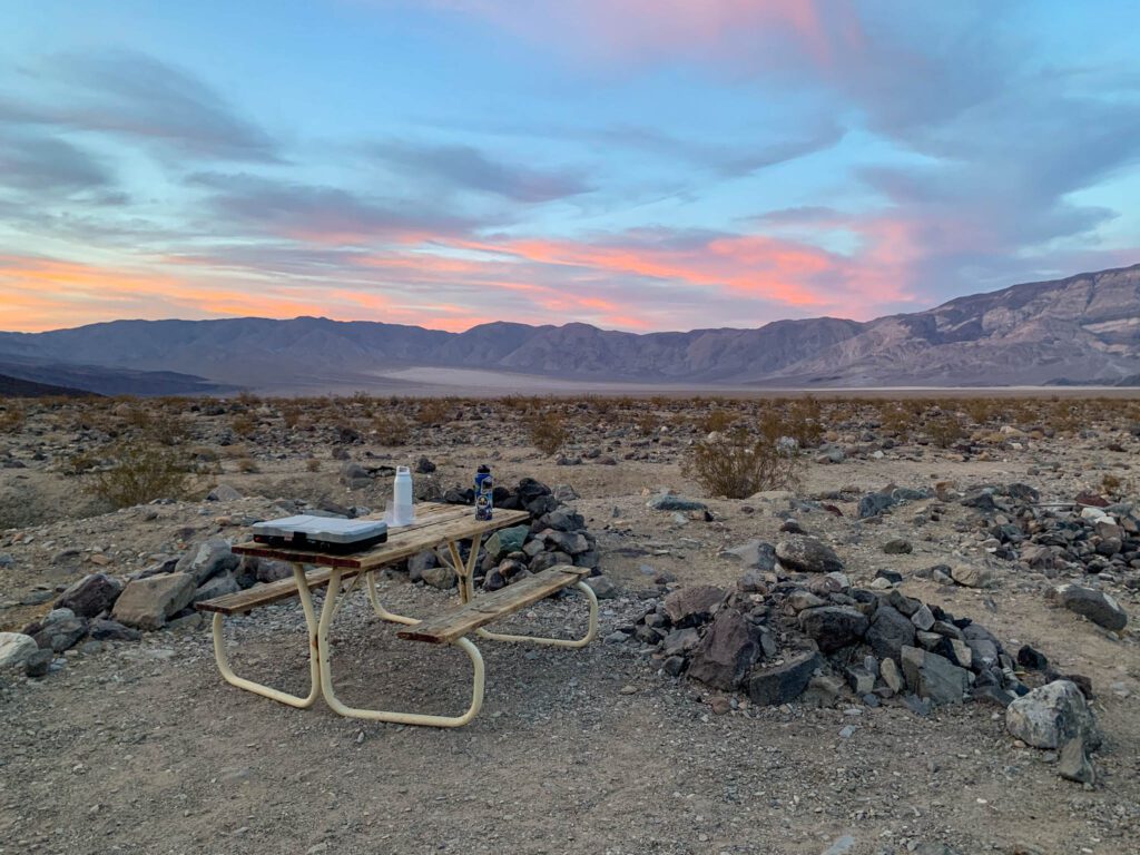
There are a ton of campsites in Death Valley, and all of them except for Furnace Creek Campground are first-come-first-served.
Furnace Creek Campground has 136 sites, and takes reservations between the months of October and April (roughly the 15 th of each month).
This is where we stayed, and it’s a fairly nice campground. Potable water, flush toilets, sinks to do dishes – it has it all. It’s open all year, and becomes first-come-first-served over the summer.
The other two campgrounds in the area are Sunset Campground (270 sites!), which we mistook for overflow parking for the visitors center because it’s literally just a dirt parking lot with a few bathrooms – no tables or fire pits here, which means it’s better for RVs – and Texas Springs Campground (96 sites), which is up on the hill with a nice view over the valley below.
After the Furnace Creek area, your next best bet is going to be Stovepipe Wells Campground , which is first-come-first-served and has 190 sites, making it the second biggest campground in the park.
We stopped by to check it out, and it’s nothing special, but if you can’t snag a site near Furnace Creek, it’ll do just fine. You’ll just be a bit further from the bulk of the sites in the park.
There are a smattering of other campgrounds throughout the park, and some of them might be good if you’re planning to hike Telescope Peak or explore the more remote northern parts of the park.
Tips for Camping in Death Valley
There are some things to consider if you’re planning to camp in Death Valley.
First is the fact that the vast majority of the sites in the park are first-come-first-served . If you’re coming on a weekend, you’ll need to plan on securing your site as soon as possible.
As of the time of writing (April 2021), Texas Springs and Mesquite Spring fill up by 7pm on Friday night, and by 1pm on Saturday. Stovepipe Wells fills around the same time.
On the bright side, you’ll probably be able to find a site at Sunset Campground, it just won’t be such a pleasant camping experience.
The other thing to keep in mind is that a lot of the campgrounds are straight up closed during the hot summer months , so if you’re planning on visiting when the valley is at its hottest (first of all, don’t), you’ll need to make other plans.
Furnace Creek Campground is the only well-located spot to camp, and with such a limited number of campsites in the park over the summer, it can fill up – particularly over long holiday weekends.
Emigrant and Mesquite Spring are also open over the summer, but are not ideally located for exploring the park.
Find more information on camping in Death Valley here .
Tips for Visiting Death Valley National Park
Here are some tips that we picked up over the course of our trip that you may (or may not) find useful as you plan your trip to Death Valley.
- When they say Death Valley is hot, it’s not a joke. Temperatures are regularly above 100 degrees F in the warmer months (April to September), which means you need to be extra careful to stay hydrated and wear sun protection. Wear plenty of sunscreen, a sun hat, and drink at least a gallon a day. We were regularly dehydrated despite drinking as much water as we could.
- There is cold water at the Furnace Creek Visitors Center, which is a lifesaver! There is also water at most campgrounds, and at Stovepipe Wells, but it was basically warm.
- Stop at the rangers station to show your National Parks Pass (or pay the $30 entrance fee) and you’ll get an orange piece of paper that you can place on your dashboard – the passes warp in the heat, so they give you the paper to keep your pass intact.
- There are electronic kiosks at most entrances where you can pay the entrance fee. I think that’s the first time we’ve seen them at a national park, which is cool! There’s one at Furnace Creek, Stovepipe Wells, and along 190 on the way into Death Valley from the east entrance (from Vegas).
- There are only a couple of places to eat in Death Valley – mostly at Furnace Creek and Stovepipe Wells. You could also bring a cooler and pack a lunch to enjoy on the road, which is what we do.
- There’s essentially no cell service in the park , with the exception of very spotty service at the Furnace Creek Visitors Center. Plan on downloading an offline Google Map of the park, or grabbing a paper map before your trip.
- The official park map has handy markings that show which roads are paved, which are unpaved but suitable for regular passenger vehicles, and which roads require 4WD / high-clearance.
- Death Valley is a big park – over 5,000 square miles – which means you’ll be driving a lot. T here are gas stations at both Furnace Creek and Stovepipe Wells , but it’s going to cost you an arm and a leg to fill your tank. Make sure to fill up your tank outside the park, which will save you upwards of $2 per gallon.
A Complete Guide to Planning an Amazing 2 Day Death Valley Itinerary
Below, you’ll find a fairly detailed guide to our take on how to plan an amazing 2 days in Death Valley.
Plus, below that, we have an additional section on what to do with 3 days in Death Valley, both with a high-clearance vehicle, and without, in case you find yourself with more time.
Note : We’re assuming you arrive in Death Valley the night before, and have two full days in Death Valley, leaving on the morning of the third day to head home, or onto your next stop (might we suggest Zion National Park or Yosemite?).
Day 1: Dante’s View, Zabriskie Point, Golden Canyon, and Badwater Basin
Experience the southern circuit of highlights on your first day in Death Valley, which will take you on a loop that starts with a spectacular view over Badwater Basin from 5,000 feet above, and ends with you on the floor of the basin at the lowest point in North America.
Unfortunately, you’re going to have to choose between the two best sunrise spots in the park – Dante’s View and Zabriskie Point.
We chose Dante’s View, because it makes the most sense from an itinerary perspective.
Sunrise at Dante’s View
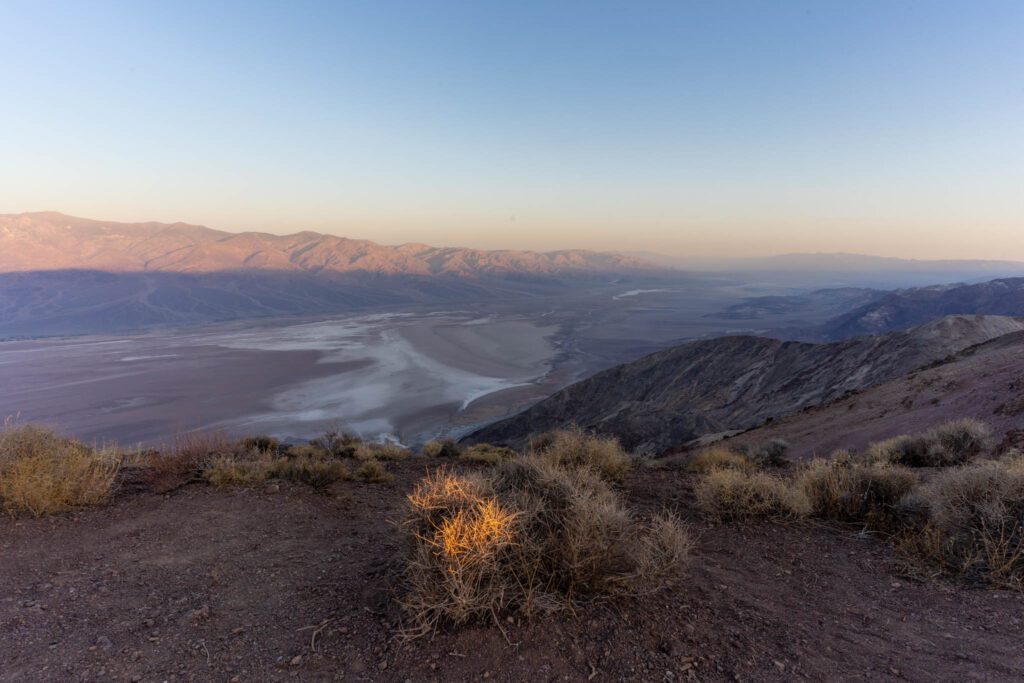
Dante’s View is a bit of a drive to get to, but we think it’s 100% worth it to get an incredible view over Badwater Basin and beyond. Star Wars nerds (like me) might recognize this as the Mos Eisley overlook from A New Hope.
At just a hair under 5,500 feet, this puts you a whopping 5,700 feet above Badwater Basin with spectacular views over the valley backed by Telescope Peak (which is at 11,000 feet) and the rest of the Panamint Range.
There’s a trail that follows the ridge to the north that leaves from the north end of the parking lot. It’s worth following for a bit to get a different view of the valley below – we went for about a quarter of a mile before heading back and moving on.
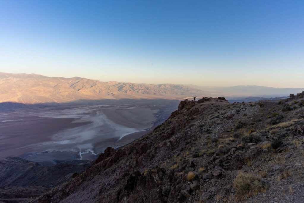
Oh, and there’s a bathroom at the trailhead (or rather just below it).
Twenty Mule Team Canyon
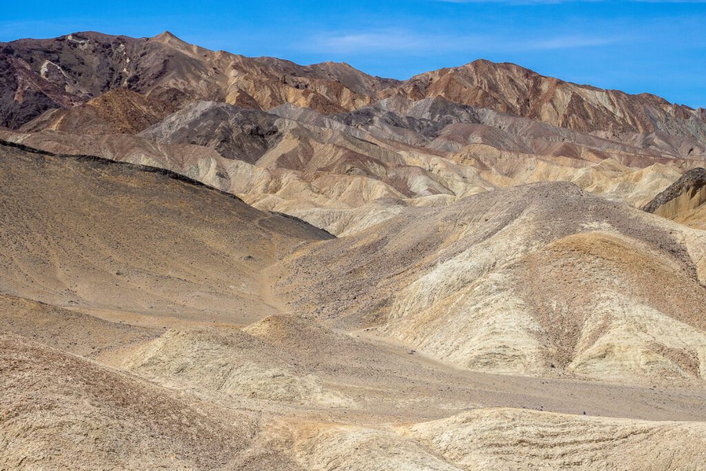
On the way from Dante’s View to Zabriskie Point is Twenty Mule Team Canyon, a road that was once used for transporting borax during mining operations.
It’s a 2.7 mile drive through the rolling golden hills, and there are a couple of spots where you can pull over and do a short hike to a vista point.
It’s unpaved, but we were totally fine in the minivan, so it’s suitable for most (if not all) passenger vehicles.
Zabriskie Point
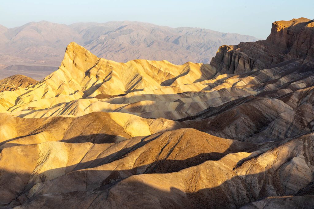
Zabriskie Point is the next stop on your list, and it’s one of the more spectacular vistas in the park. You’ll likely share the view with a bunch of people, so don’t go into it expecting solitude.
A short, paved walk from the parking lot takes you up to a platform with panoramic views.
To the south you’ll see the rolling golden hills of Twenty Mule Team Canyon, this time from above.
To the north is a view over Badwater Basin, with a pointy peak in the foreground and magnificent textures in the rocks that form picturesque waves.
Hike Golden Canyon and Gower Gulch
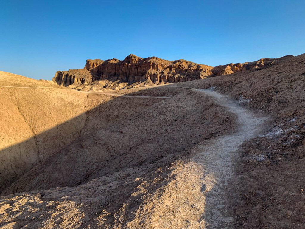
The Golden Canyon and Gower Gulch loop was our favorite hike in Death Valley. Usually, you would do this hike from the Golden Canyon Trailhead on Badwater Road, but you can also do it from Zabriskie Point, which is our recommendation.
The main route is a 6.5 mile loop that takes you from Zabriskie Point, down through Golden Canyon to the Golden Canyon Trailhead, and back up through Gower Gulch.
The first part of the Gower Gulch portion of the hike (coming from the bottom) was our favorite stretch, so it’s well worth doing the entire loop. Bring plenty of water – more than you think you need – because it’s super exposed.
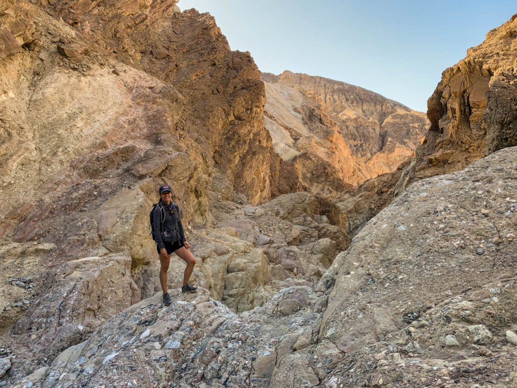
There are a couple of ways to alter this hike, depending on what you’re up for. I’m including the NPS Map here to help illustrate what I’m talking about.
Essentially, this hike is made up of two different figure eight loops. On the version of the hike I described above, you’re doing both loops in full. To shorten the hike, you’ll basically only do one of them.
- Add the 1 mile (roundtrip) offshoot to the Red Cathedral , an impressive rock formation just off the main trail.
- Complete the loop from the Golden Canyon Trailhead up through Gower Gulch, across the short 0.3 mile connector trail, and down the Golden Canyon trail, skipping the Badlands Loop entirely. This is a 4.3 mile hike, and is our second favorite way to do the hike.
- Complete only the Badlands Loop , which is 2.7 miles, and only includes the eastern part of the figure eight. We think you’re missing out here, so we’d opt for a different way of doing the hike.
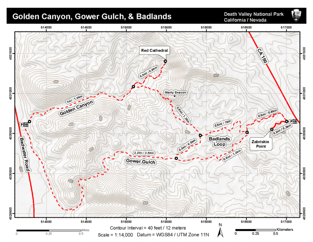
After your hike, we’d recommend taking a break to beat the heat. From Zabriskie Point, you’re fairly close to the Furnace Creek Visitors Center, and likely your accommodations.
Take a break for lunch, either at one of the restaurants near Furnace Creek, in your room, or parked in the shade at the Visitors Center (no shame – that’s what we did multiple times!).
Check out the giant thermometer at the Visitors Center, which gives you the temperature reading.
A couple of hours before sunset, head out again for an adventure down Badwater Road.
Artist Drive & Artist’s Palette
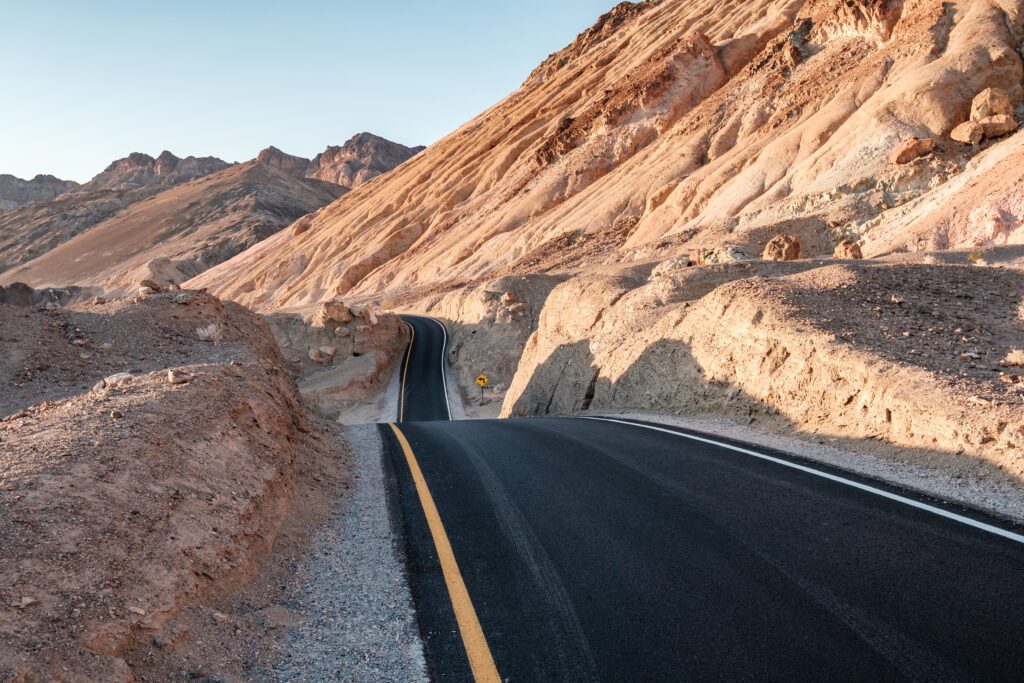
Artist Drive is your first stop, located about ten miles down Badwater Road. It’s a nine mile one-way loop that climbs up into the hills and winds its way through canyons and vista points before putting you back out on Badwater Road.
There are a couple of places to park and get out of the car, and we think you should do just that. It’s only nine miles, but it took us about an hour to drive the entire circuit.
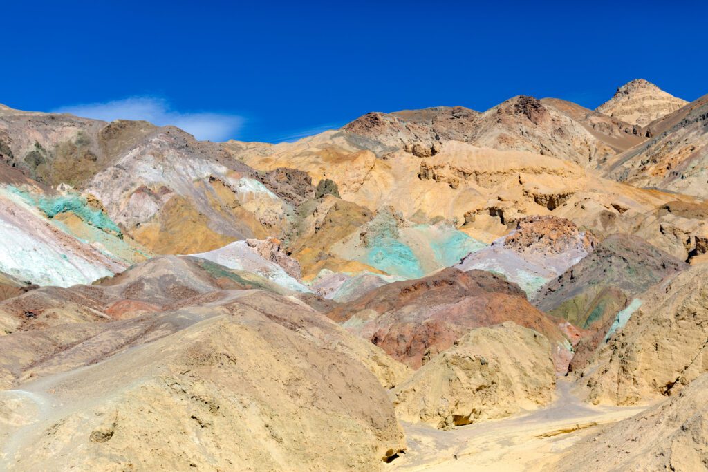
Artist Palette is about half way through, and there’s a turnoff the main road to the right with a relatively small parking lot.
There’s a nice view from the parking lot, but for the best view, leave the parking lot and climb up the hill to your left, which has a well-worn path that leads to an overlook where you’ll be able to see the colors of the Palette in all their glory.
The range of colors – greens, oranges, reds, and more – are a result of the metals that are found in the hills.
Over time, they’ve oxidized, creating a mish-mash of colors that make it one of Death Valley’s many unique features.
Note that if you have an RV, you can’t drive this road . There’s a 25 foot limit on all vehicles because the canyon is narrow and winding at points.
Natural Bridge
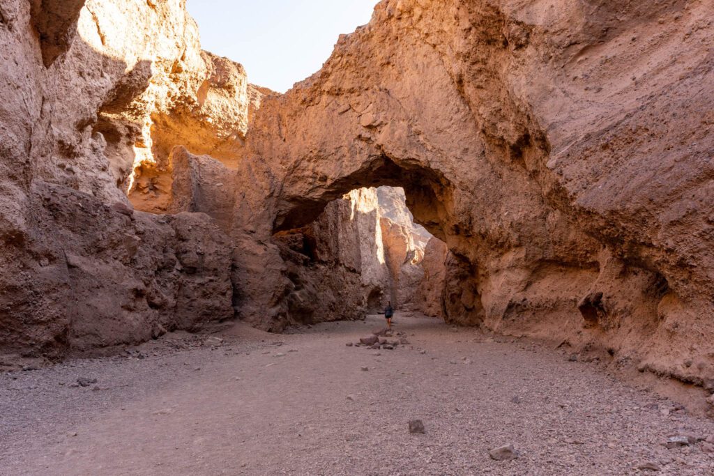
The loop you just finished spits you back out onto Badwater Road. Continue south until you reach the turnoff for Natural Bridge, which is fairly well marked.
The road here is gravel, but we did it just fine in our minivan, and it’s marked as suitable for all vehicles.
From the parking lot, it’s a very short hike up into the canyon, where there’s a… what’s the word I’m looking for… natural bridge? It’s about a half mile into the canyon, and it’s a relatively easy hike.
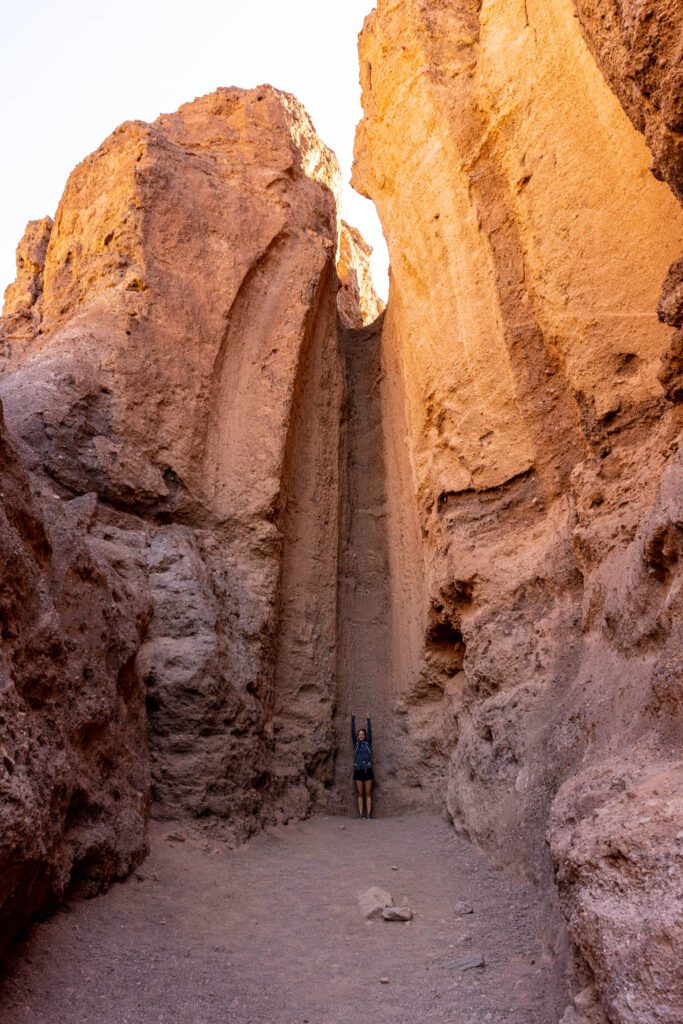
There’s a cool dry falls past the arch, just an extra few hundred feet up the trail that’s worth visiting.
Badwater Basin
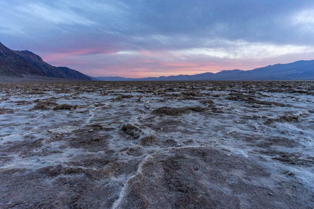
Remember when you started your day with Dante’s View, an epic viewpoint of the salt flats of Badwater Basin from more than 5,000 feet up?
Time to end your day by getting up close and personal with the epic Badwater Basin, the lowest point in North America at 282 feet below sea level. The salt flats here are one of the more unique parts of Death Valley.
I laughed at one of the informational signs that pointed out that most of white mineral covering the ground is sodium chloride, aka table salt.
It’s hard to imagine in the present day, but at one point, Lake Manly covered this basin.
Obviously, it has since evaporated in the heat. Since there’s no outlet for the lake, it accumulated a bunch of minerals (notably, salt) that were left behind when the lake disappeared.
There’s still a small, very salty pond near the parking lot – DO NOT VENTURE OFF THE BOARDWALK near the lake. It’s a very fragile ecosystem, and you could disturb it.
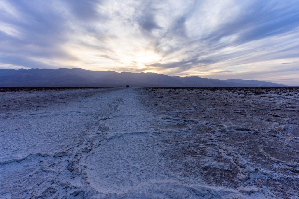
Walk out on the well-worn path across the basin for about a mile, where you’ll have the best view of the surrounding landscape. At your back, Dante’s View and the ridge that you hiked earlier.
In front of you is Telescope Peak, which towers over Dante’s view with a difference of over 11,000 feet – that’s more than two miles!
The salt flats reflect heat, which makes it SUPER hot in the summer months. The National Park Service does not recommend this walk after 10am in the summer.
Day 2: Mosaic Canyon, Ubehebe Crater, and Mesquite Flats Sand Dunes
Your second day in Death Valley involves a lot of driving, but it’s going to be worth it.
Start with our favorite slot canyon hike in the park, spend the middle of the day in your AC-oasis as you make your way to the Ubehebe Crater, and head to Mesquite Flats Sand Dunes for sunset.
Mosaic Canyon
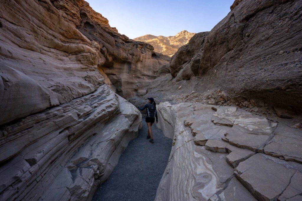
Early on your second day, head out to Mosaic Canyon, which is west of Stovepipe Wells, about an hour away from the Furnace Creek Visitor Center (if that’s where you’re staying).
We say early because we did this first half of this hike before the sun rose above the canyon walls, and it was spectacular. On the way back down, the sun had risen above the walls and the harsh light was not nearly as enjoyable, not to mention the heat.
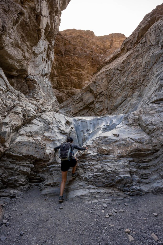
Get there as early as you can – before 8am if possible.
The road to the trailhead is dirt, but we were able to do it easily in the Honda Odyssey.
The best part of this hike is probably the first half mile or so, when the canyon is narrow and you’ll be up close and personal with the ever-changing textures of the walls.
It’s mesmerizing, and fascinating to think about how that even happened – how was there ever that much water here?
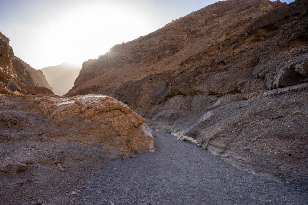
After that, the canyon oscillates between wide and narrow. There are several dry falls where you’ll need to do some scrambling, but nothing too intense.
Until you reach the towering dry falls at about a mile in. There’s a detour up the hill to the right, which was marked with an arrow made of rocks when we were there.
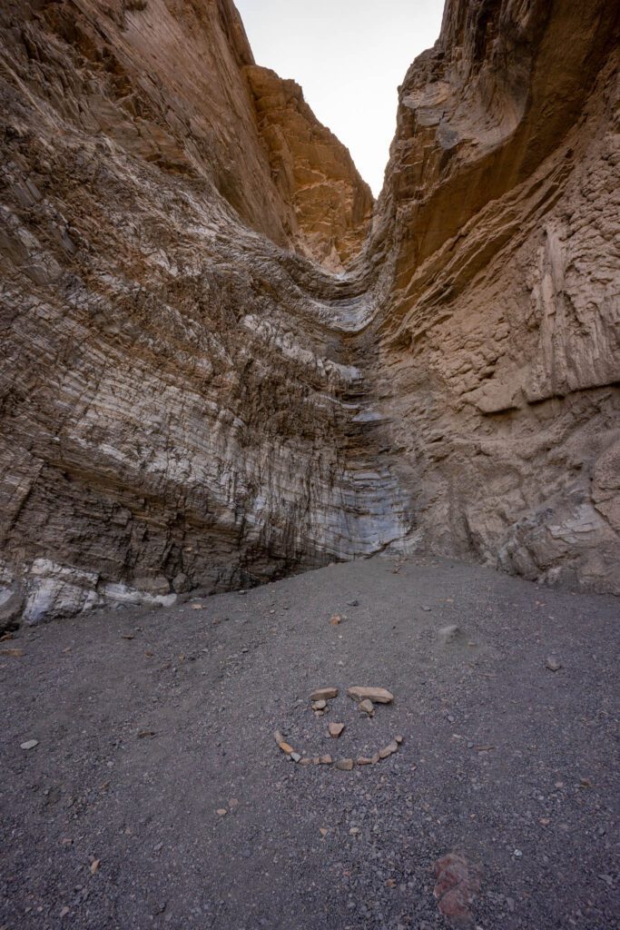
Continue through the canyon until you reach the end, which is another dry falls. This one is clearly marked with a STOP made of rocks in the sand (and a smiley face), and there’s no detour to get around it.
Ubehebe Crater
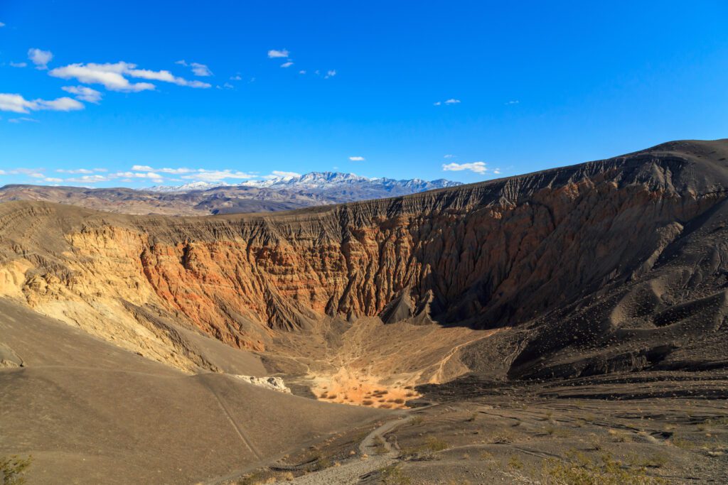
You might think about doing the Mesquite Sand Dunes now, considering you’re going to pass right by it, but we’d recommend waiting until sunset, which is a far better time to be out there, when the dramatic shadows bring out the texture of the sand, and the golden light illuminates the dunes in a deep orange color.
Instead, head up to the Ubehebe Crater, which is a bit of a drive (an hour, give or take ten minutes), but is worth the journey.
You’ll take Scotty’s Castle road most of the way up there, turning left onto Ubehebe Crater Road when it forks.
The crater, which is 600 feet deep and over a half mile across, is a sight to behold. You have a few different options in terms of what to do when you’re up here.
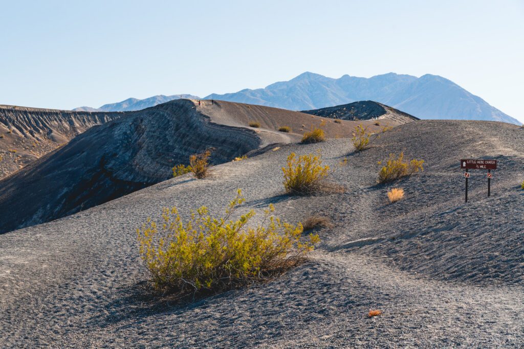
You could circumnavigate the crater , walking around the entirety of the rim, which is a relatively easy 2 mile loop that gains about 400 feet of elevation over the course of the hike.
You could also hike down to the crater floor , which is about a half mile round trip and loses (then gains) 500 feet over that short time, which is no joke. The climb back up is going to be a slog, so be prepared with plenty of sun protection and water.
You could also do the short hike to Little Hebe , which is a smaller crater right next to Ubehebe. The short hike is about a mile long, and gains minimal elevation so it’s mostly flat.
Or, you could do all three! Which is what we’d recommend. Start from the parking lot, descending to the Crater floor first, then come back out and start the full loop heading clockwise around the crater.
At about 7 o’clock (if you pretend the crater is a big clock, NOT ACTUALLY THE TIME), you’ll reach an offshoot that leads to Little Hebe Crater.
Do the short loop and continue back along the crater rim to the parking lot. It’s about two and a half miles with 700 feet of elevation gain, but the majority of that comes with the descent to the crater floor.
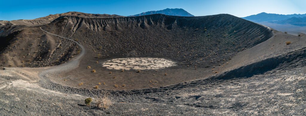
Note : If you have a high-clearance, 4WD car and you’re up for a bumpy drive, head out to Racetrack Playa, home of the sailing stones, which move across the ground in a mysterious way. It’s a long, bumpy journey that will take several hours, and it should not be attempted by people who don’t have a suitable vehicle.
Scotty’s Castle
Scotty’s Castle is worth the short detour on the way back from the crater. It’s a villa in the middle of the desert, built in the 1920’s and 1930’s by a millionaire from Chicago as a winter home.
Except he accidentally built it on government land rather than the land he actually owned – big OOPSIE DAISY.
After the death of the owners, the National Park Service bought it, and today it’s open to the public and you can take a fun history tour with a guide who’s dressed up in clothing straight out of the 30’s. Most of the villa is still intact.
Note for 2023: Scotty’s Castle is closed through the end of 2023 due to a major flood, unfortunately. Opening date is still undetermined, check the park website to check the status for your trip.
Mesquite Flats Sand Dunes
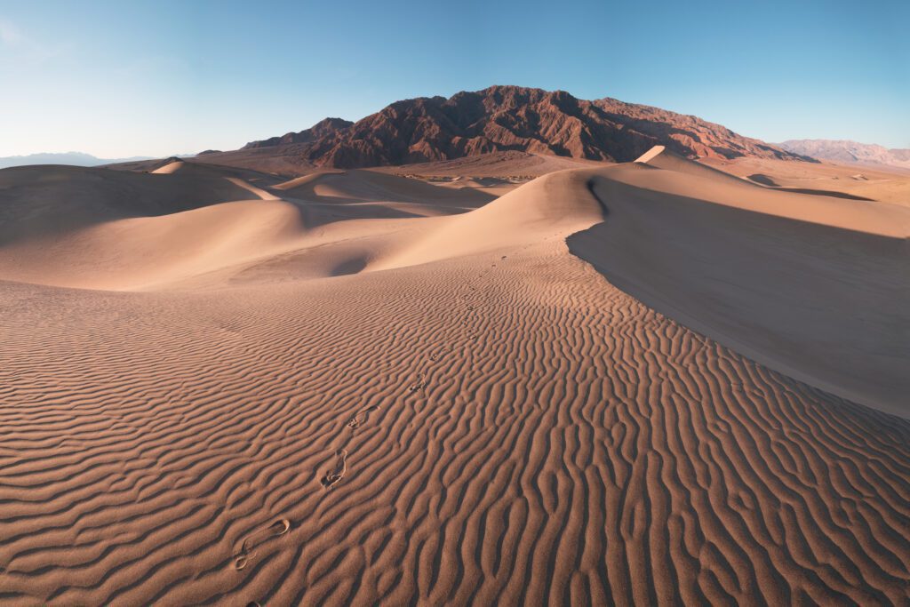
Finish your day back near Stovepipe Wells at the Mesquite Flats Sand Dunes.
It’s an easy hike out to the dunes from the parking lot, but remember that you’ll be walking on sand, so it’s significantly harder than it looks.
You can sand board here, if you happen to have a board or a sled. Or just slide down on your butt, but be prepared to get sand everywhere.
This hike is 2.8 miles long if you go all the way out to the star dunes, which are, pardon the pun, the star of the show.
What to Do with 3 Days in Death Valley
First of all, two or three days is not nearly enough to see everything Death Valley has to offer.
It’s a massive park, and you’re going to have to pick and choose what you want to see with only a couple of days. This is particularly problematic because of the long drive to get there and back from anywhere in California.
With that said, here are some ways to spend the last of 3 days in Death Valley IF you have a 4WD vehicle.
Telescope Peak
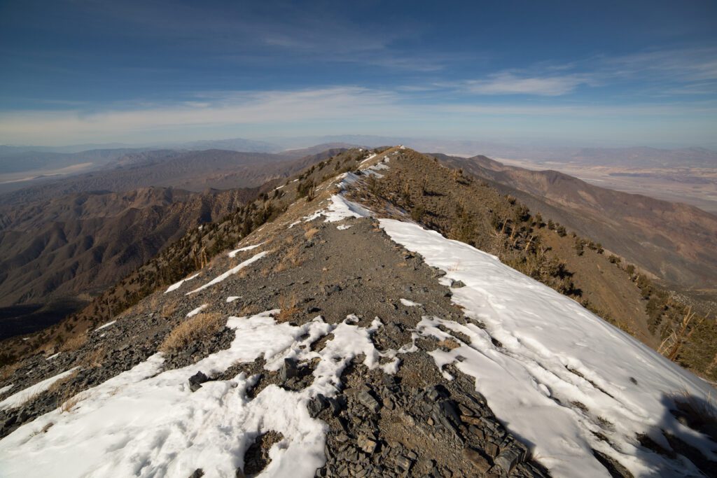
Telescope Peak is the tallest mountain in the Panamint Range, which towers more than 10,000 feet above you when you’re in Badwater Basin. Getting to the summit involves a grueling 14 mile hike with 3,000 feet of elevation gain.
Which means you’re climbing 6,000 – 7,000 feet to reach the trailhead from the floor of Death Valley. You’ll approach from the western side, which means you’ll head out past Stovepipe Wells. The last 1.5 miles of the road to reach the trailhead is rough, and the NPS does not recommend it for normal vehicles.
There is a campground at the trailhead, which would be a nice place to spend the night before your climb so that you can get an early start.
The trail starts by alternating between aggressive climbing and winding through meadows until you get to the switchbacks, which start at about 4 miles in. That’s where the climb starts to pick up again as you make your way to the summit, which sits at 11,000 feet above sea level.
Note that this hike is really only doable in the spring and summer, when the trail is no longer icy and the road is clear of snow. Because of the elevation, it’s much, much cooler than the rest of Death Valley, and the ice on the trail lingers well into the spring. Make sure to check conditions at the Visitor Center before you attempt this hike.
Darwin Falls
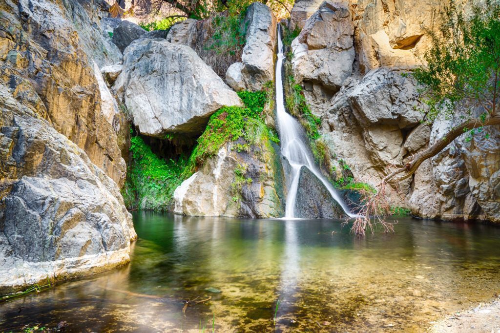
Wait, a waterfall in the desert? That can’t be right. Darwin Falls is an oasis in a landscape with very little water. It’s just west of Panamint Springs Resort, which makes this a great stop after Telescope Peak or on your way to or from Los Angeles.
The road to get to the trailhead is a little rough, so it’d be best to have a high-clearance car.
For what it’s worth, the official park map lists the road as “high-clearance recommended,” though we’ve read reviews that it’s doable with a normal car. Note that there are no restrooms at the trailhead.
The hike itself is moderate, gaining 450 feet in the mile it takes you to get to the waterfall (that’s a one-way distance, round trip this hike is right at two miles). It’s an unmarked trail, but the path will be fairly clear once you get there – tons of people do this hike.
There is no swimming in the pool – it’s a source of drinking water for the surrounding area.
Poke around Leadfield, an abandoned lead mining town along the road to the canyon, and Rhyolite, a ghost town just northeast of the eastern entrance, for some extra fun while you’re out there.
Titus Canyon
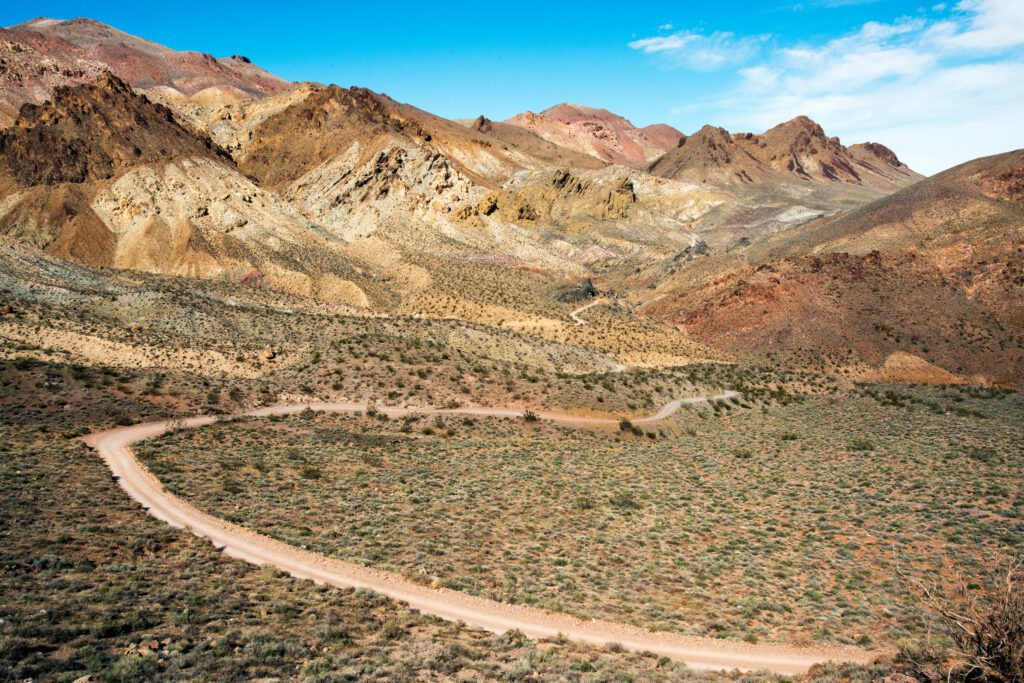
We were really bummed that we couldn’t do this drive, because it looks great! Titus Canyon is actually along the way up to the Ubehebe Crater, so you could add it as a stop on your way back from the Crater on day 2 if you have the time.
This drive is going to be similar to Twenty Mule Team Canyon, but significantly more rugged and scenic.
You can either start it from the western end, which is along that road up to the crater, or on the eastern end , which is along Hwy 374 outside the eastern edge of the park.
The canyon walls tower above you for the 27 mile drive, which is rougher on the eastern side of the canyon and can get a little bit sketchy when two cars end up trying to pass each other going opposite directions on the narrow, one way road.
What to Do With One Day in Death Valley National Park
Only have one day in Death Valley? Here’s how we would compress the 2 day itinerary above into a single, action-packed day.
This will work best if you have an overnight in the park, either to get an early start or to allow you to spend more time in the park around sunset and not have to worry about driving back to your accommodations.
Start your day with Dante’s View for the sweeping views over the valley below, which is where you’ll end the day (similar to the first day of the two day itinerary above).
Then, drive down to Zabriskie Point , stopping at Twenty Mule Team Canyon along the way to do the scenic drive.
Next, drive around to the Golden Canyon trailhead and do the hike up into Golden Canyon, looping around through Gower Gulch, which is going to be a moderate hike of about 4.2 miles.
Next, we’d recommend heading down to Badwater Basin and walking out onto the salt flats. If you’re not here during the winter, it’s going to be hot! On your way back towards the middle of the park, make stops at Devil’s Golf Course and Artist Drive .
By now, it should be time for a brief siesta, so head into the area around Furnace Creek and take a lunch and water break, either in the shaded parking spots at the Visitor Center, or at the restaurant at the Oasis at Death Valley.
For the afternoon, make the drive up to the Stovepipe Wells area and do the hike out to the Mesquite Sand Dunes . The light here is particularly spectacular around sunset, when the dunes light up with a golden orange color.
That’s an action packed day – if you want to cut some time, either because you want a more leisurely pace or because you have a long drive to Vegas at the tail end of the day, skip the Golden Canyon hike (or make it shorter by just doing a portion of the loop).
- 4 Days in San Francisco: A Local’s Guide
- Where to Stay in San Francisco
- How to Plan a Perfect San Francisco to Los Angeles Road Trip
- Plan an Incredible Seattle to San Francisco Road Trip
- The Best Day Trips from San Francisco
- 5 Days in Los Angeles, California
- Where to Stay in Los Angeles, California
- Gluten Free Los Angeles: The Best GF Eats in L.A.
- Gluten Free San Diego: Complete Travel Guide for Celiacs
- Where to Stay in San Diego, California
- A Perfect Northern California Road Trip

Matt is the founder and main writer behind Wheatless Wanderlust, which he started back in 2018 as a way to share his gluten free travel guides with his fellow Celiac travelers.
Since then, Matt and his wife Alysha have visited 18 national parks, spent three months in Europe and six weeks in Colombia, and have explored every corner of the Pacific Northwest, which is where Matt grew up.
He writes super detailed guides to the places they visit, bringing together personal experience and historical context to help YOU plan an amazing trip.
Hey Matt and Alysha
I hope you are doing great. What are your thoughts on visiting death valley in on Valentine’s weekend? I want to plan a trip for my wife that covers Las Vegas and Death Valley. We love national parks and haven’t been to a dessert such as death valley. Can you please give some tips? Thanks
Regards Vikrant Kaushal
Hey there! February is a great time to go to Death Valley. It’s going to be cool enough to actually do things in the middle of the day, which was the problem we ran into in late March – it was blazing hot by 10am! All of our best tips and tricks are in this guide – let me know if you have any specific questions as you plan your trip and I’d be happy to answer them.
Leave a Reply Cancel reply
Your email address will not be published. Required fields are marked *
This site uses Akismet to reduce spam. Learn how your comment data is processed .

Los Angeles to Death Valley road trip
- Post last modified: March 14, 2024

Driving from Los Angeles to Death Valley? Make the most of your journey with this complete itinerary, containing not only the best stops along the way but also all the must-see spots within Death Valley National Park.
Disclosure: All listings are independently selected. If you buy something through our links, we may earn an affiliate commission. Learn more ›
Route from LA to Death Valley
- Vasquez Rocks
- Red Rock Canyon
- Trona Pinnacles
- Mosaic Canyon
- Mesquite Flat Dunes
- Badwater Basin
- Artists Drive
- Zabriskie Point
- Dante’s View
Head north from LA — supercharging the itinerary with otherworldly Vasquez Rocks, Red Rocks Canyon State Park and Trona Pinnacles — before entering Death Valley via State Route 178 on the park’s west side. Continue by ticking off the biggest Death Valley attractions and, preferably, spend your night(s) at the heart of the massive park.
When it’s time to leave, exit Death Valley through State Route 190 in the east. There are fewer attractions on the way back, but the itinerary’s loop shape keeps things interesting until you’re back in LA.

- Total distance: 644 mi / 1,036 km
- Total driving time: 12 h 45 min
1. Los Angeles
Los Angeles offers myriad world-class experiences. If you’re down for it, tick off some of the city’s best sights before taking off for Death Valley.
- Santa Monica Pier: This pier jutting out from Santa Monica Beach is more than a landmark. You can, of course, come only to soak up the salty views, but the array of eateries, iconic rides, street performers and the sign marking the end of Route 66 may distract you.
- Universal Studios: Hop between themed lands loaded with thrilling attractions. The big-ticket item is the Studio Tour, taking you behind the scenes of some of your favorite movie classics.
- Disneyland: It’s called the “Happiest Place on Earth”. Bring the kiddos — or just your inner child — and embark on a fun-filled adventure with some of the world’s most famous characters.

2. Vasquez Rocks
45 miles (72 km) / 1 h
Wanted and highly dangerous, bandit Tiburcio Vasquez used these inclined sandstone rocks in the Sierra Pelona to remain a free man in 1874. Star Trek, The Flintstones, MacGyver and The Big Bang Theory — to name a few — include the classic productions having featured the location.

3. Red Rock Canyon State Park
76 miles (122 km) / 1 h 15 min
California’s Red Rock Canyon (don’t confuse it with Nevada’s) wows you with towering red cliffs reaching for the sky. Step out of the car to gaze at massive geological masterpieces in never-ending shapes, colors and textures.

4. Trona Pinnacles
54 miles (87 km) / 1 h 15 min
Stop in the middle of nowhere to find a scene like no other. Survey over 500 peculiar tufa spires formed tens of thousands of years ago when their nowadays dry home, the Searles Lake Basin, was under 640 feet (195 m) of water.
Note: The final five miles (8 km) are on a dirt road that is usually 2-wheel-drive accessible but may be closed during winter or after heavy rainfall.

5. Mosaic Canyon
88 miles (142 km) / 2 h
You made it. This is your first Death Valley stop!
Polished smooth by rainstorms, Mosaic Canyon has all that makes a great hike great. Feel the excitement as it narrows and opens and, if you feel adventurous, continue past the blocking boulders after 1.3 miles (2.1 km).

6. Mesquite Flat Sand Dunes
4 miles (6 km) / 15 min
Hiking, sandboarding and rolling are all ways to experience these 100-foot (30 m) Sahara-like dunes. If you have time, the 2-mile (3.2 km) return hike to the tallest dune is the one to try; because of its soft nature, allow 1.5 hours.

7. The Oasis
23 miles (37 km) / 30 min
When you need to power up, The Oasis has you covered. Choose from two places to stay — the casual Ranch or upscale Inn — eateries, a general store and a souvenir shop.
8. Badwater Basin
18 miles (29 km) / 30 min
No Death Valley road trip is complete without a stop at Badwater Basin. The lowest point in North America — 282 feet (86 m) below sea level — boasts otherworldly salt plains stretching some 200 square miles (518 km).
Tip: Stop up the road to marvel at the salt formations of Devils Golf Course too.

9. Artists Drive
8 miles (13 km) / 15 min
Take a delightful mini road trip on Artist’s Drive. The 9-mile (14.5 km) route is framed by red eroded hills, and that it’s one way, from south to north, adds to the enjoyment. Be sure to pull over at Artist’s Palette, where nature has splashed unlikely rainbow colors across the slope, rivaling all-time greats Leonardo Da Vinci and Michelangelo.

10. Zabriskie Point
17 miles (27 km) / 30 min
How to approach Death Valley’s maybe most famous viewpoint? At a minimum, go on the 5-minute walk to the elevated viewing platform, affording brilliant vistas of striped badlands changing color with the sun. But also consider hiking to the valley floor for as marvelous views but much fewer fellow admirers.

11. Dante’s View
20 miles (32 km) / 30 min
Nearly 6,000 feet (1,829 m) above Badwater Basin, Dante’s View provides a breathtaking bird’s-eye view of Death Valley. Soak it all up, from the reflecting salt plains at the valley’s bottom to the imposing Panamint Range.
12. Los Angeles
291 miles (468 km) / 4 h 45 min
After saying goodbye to Death Valley, a drive of just south of 5 hours takes you back to Los Angeles.

Where to stop on your way back from LA
About 2.5 hours into your drive from Death Valley to Los Angeles, the historic Route 66 town of Barstow makes a nostalgic stop. Check out the adjoining Route 66 Mother Road Museum and Western America Railroad Museum followed by a diner-style meal at Roy’s Cafe, set right on America’s most famous highway.

- Where to stay in Death Valley
With over 3 million acres, Death Valley is the largest national park in the contiguous USA. To make your experience as pleasant as possible, avoid tiring back-and-forth drives by bedding down inside the park.
In Furnace Creek, Death Valley’s epicenter, the Oasis is an elegant resort comprising two separate lodging options: The Ranch (casual) and The Inn (upscale). Each facility features a spring-fed pool and on-site dining.
Best time to go from Los Angeles to Death Valley
Summer in Death Valley can be outright dangerous, with daytime highs regularly climbing above 110°F (43°C). If you can’t avoid the summer, though, bring plenty of water and avoid hiking during midday.
To dodge the extreme heat, visit between late fall and early spring. Winter in Death Valley means pleasant days in the mid-60s (18°C) but chilly, sometimes freezing nights. Typically running from mid-February to mid-April, the wildflower season can add extra color to your Death Valley adventure.

LA to Death Valley road trip FAQ
This ultimate Los Angeles to Death Valley loop is 644 miles (1,036 km) long, taking 12 h and 45 min excluding the time you need for the stops along the way.
Death Valley features all the ingredients that makes a great road trip great. Conquer 100-foot (30 m) tall sand dunes, hike past unique geological formations and absorb epic views from roadside overlooks.
Death Valley has sixed paved entrances. The closest from Los Angeles is the one used one this itinerary, on State Route 178 / Panamint Valley Road, 214 miles (344 km) and 3 h 30 minutes away.
Sign up for our newsletter to get monthly updates.
Related guides
- What to do in Death Valley
- LA to Grand Canyon road trip
- LA to Nashville road trip
- LA to Yellowstone road trip
- LA to Zion NP road trip
- LA to NYC road trip
Share this story Share this content
- Opens in a new window
Leave a Reply Cancel reply

Los Angeles to Death Valley
573.8 miles: 10 hours, 20 minutes
Wind-swept sand dunes. Otherworldly badlands. Serpentine stone canyons. The geologic wonders of Death Valley National Park lie within a day's drive of L.A. And this road trip loop offers the chance to see them all—from the lofty peaks of the Panamint Range to the lowest spot in North America (Badwater Basin). In summer, brace for blistering heat.
Los Angeles to Furnace Creek
Furnace creek to death valley junction, death valley junction to barstow, barstow to los angeles.
274.8 miles: 4 hours, 55 minutes
With L.A. in the rearview mirror you'll travel to the arid Owens Valley before approaching the park from the west. The road climbs and winds through the rugged Panamint Range, then drops to the valley floor. Near the tiny tourist village of Stovepipe Wells (you'll find a motel, food, gas and supplies) are the park's most easily accessible sand dunes; a sunset visit is best.
Recommended Stops
30.3 miles: 0 hours, 34 minutes
At the heart of the valley is oasis-like Furnace Creek (home to two hotels and the NPS visitor center), an ideal base for exploring the park's natural attractions. Catch sunrise at the famed Zabriskie Point overlook. Hike gorgeous Golden Canyon. Stand 282-feet below sea level at Badwater. Do sunset at the colorful, geologic kaleidoscope that is Artist's Palette.
232.5 miles: 3 hours, 51 minutes
Though the scenery can't compare with that of Death Valley, the stretch of road between the junction and Baker offers some decent desert landscapes. Up for a bit of cheesy fun? There's a touristy ghost town just outside Barstow. Tip: It's wise to avoid this leg on Sunday afternoons when southbound I-15 is often jammed with L.A. weekenders driving home from Las Vegas.
36.2 miles: 0 hours, 58 minutes
Let's be honest—departing Barstow, the largely uninteresting scenery will tempt you to floor it back to L.A. Instead, slowing your roll will yield some interesting little attractions along the way. Back in the City of Angels, rinse off the road dust and settle in for a sophisticated dinner downtown.
Travel Like an Expert with AAA and Trip Canvas
Get ideas from the pros.
As one of the largest travel agencies in North America, we have a wealth of recommendations to share! Browse our articles and videos for inspiration, or dive right in with preplanned AAA Road Trips, cruises and vacation tours.
Build and Research Your Options
Save and organize every aspect of your trip including cruises, hotels, activities, transportation and more. Book hotels confidently using our AAA Diamond Designations and verified reviews.
Book Everything in One Place
From cruises to day tours, buy all parts of your vacation in one transaction, or work with our nationwide network of AAA Travel Agents to secure the trip of your dreams!
Ultimate 3-Day Death Valley National Park Itinerary
Sand dunes, craters, slot canyons & wildflowers. Experience the best of Death Valley National Park with this 3-day itinerary.

In this post, guest contributor Paul Martinez shares with us his full 3-day Death Valley Itinerary and helpful tips from his trip so you can experience the best that Death Valley has to offer.
At 134°F, Death Valley holds the record for the hottest air temperature ever recorded, so it’s no wonder why they call it “Death Valley”. Situated east of the Sierra Nevada and in-between the Great Basin and Mojave deserts, this is truly a land of extremes. In fact, Death Valley is one of the most extreme environments on earth with an average rainfall of fewer than three inches, and some years actually receive none!
Despite its record droughts, however, a great diversity of life manages to survive in its valley. Wildflowers can be seen sprouting through the ground in the spring, hidden lush oases provide refuge for wildlife, and kangaroo rats don’t even need to drink water their entire lives!
Here is a complete 3-day Death Valley itinerary and tips on what you need to know for your visit so you can explore the best the park has to offer.
Important Reminder: As it goes in all of the destinations we share, please practice good trail etiquette and remember to Leave No Trace . This means packing out all of your garbage (including toilet paper) and following the established rules. In the desert, this also means learning how to protect cryptobiotic soil and how it has a huge impact on our ecosystems.
Death Valley Itinerary Logistics
Getting to death valley.
Death Valley National Park is only 2 hours from Las Vegas and 5 hours from Los Angeles. It is definitely worth the drive as it is the largest US National Park outside of Alaska. Death Valley also makes for a great week of exploring nearby Sequoia and Kings Canyon National Park , and Yosemite if you are willing to venture a bit further on your road trip.
Death Valley National Park is also less than 2 hours to Lone Pine, CA which is the portal to Mt. Whitney, the highest point in the lower 48 states. Are you up for an unforgettable “lowest to highest” vacation? Go from the lowest point in the lower 48 states, Death Valley’s Badwater Basin, to the highest point, Mt. Whitney.
Best Time To Visit Death Valley
Fall, winter, and spring are the best times to visit Death Valley with milder temperatures. Spring is the most popular time due to the wildflower blooms.
While the Furnace Creek Visitor Center is open year-round, summer can be miserably hot in the park. From May – September, Death Valley is often too hot for most visitors.
Read next: Best National Parks to Visit in Spring
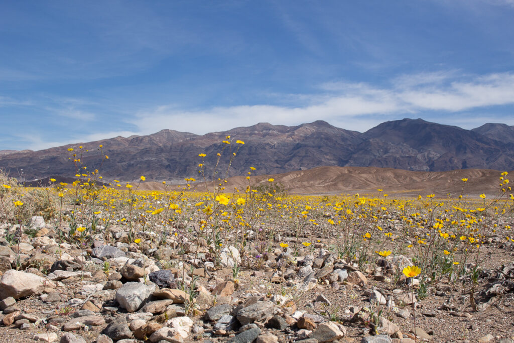
Where To Stay In Death Valley
Death Valley National Park has nine campgrounds, which doesn’t include some of the privately-owned campgrounds that also reside in the park. Furnace Creek Campground is by far the most popular and from October to April reservations can be made online for their 136 available sites. This campground is located directly behind the only visitor center in the park making it a great starting out point for adventuring!
Depending on when you’re visiting, some campgrounds will be closed for the season so make sure to check in advance. All campgrounds in Death Valley are first come, first serve (except for Furnace Creek from October through April).
We didn’t want to worry about finding a campground the day of arrival, so we booked a campsite with privately-owned Panamint Springs Resort prior to the trip. They are located on the western end of Death Valley National Park and offer incredible views of distant sand dunes and the soaring Panamint mountain range… oh and they have a bar and free showers, what’s not love?
#1 campsite finder app
Try the dyrt pro free for 30 days.
Get a FREE 30-Day membership to The Dyrt PRO, one of our favorite apps for finding campsites.
Perks include: • 5,000+ free camping locations • 1,000+ campground discount network • $0 extra booking fees • Get reservations at sold-out campgrounds, and more
Use the code BEARFOOT to get 30 days free!
Other Lodging Options in Death Valley
Not into camping? That’s okay! Death Valley is actually a great National Park for non-campers with 4 accommodation options that don’t involve a tent. Former Bearfoot Theory editor, Kim Vawter, explored Death Valley with her parents and they highly recommend the Furnace Creek Ranch as well as the famous Furnace Creek Inn. Read more about non-camping accommodations in Death Valley here .
Insider Death Valley Tips
Don’t leave home without maps.

We set out from Los Angeles around 8:00 AM and arrived in Death Valley just before noon to set up camp at Panamint Springs Resort. After setting up our tent, we headed towards the Stovepipe Wells Village area to hike through Mosaic Canyon .
Located 1/4 of a mile west of Stovepipe Wells Village, Mosaic Canyon is a two-mile gravel access road leading to the parking area. From there it was just a short walk into the canyon narrows, where the surrounding rock walls are made up of smooth, water-polished marble.
We were both in awe of how incredibly smooth the walls were. Mosaic Canyon is considered a geological wonder, and as part of the National Park System, all of its features are protected by law, so rock collecting is prohibited!

Before dinner, we drove to Mesquite Flat Sand Dunes for a stroll during golden hour. At first glance, it seemed like our plans would have to wait as clouds started to gather right over the dunes. The wind was picking up and sand was blowing everywhere. Nevertheless, we got out of our car and ventured into the sandstorm.
There wasn’t one person in sight, which for being one of the park’s most popular attractions, was astonishing. After a while, the clouds began to clear and the wind started to calm. The mixture between late afternoon light and ripples in the sand was quite the sight to see.

On day 2 of our Death Valley itinerary, we woke up at sunrise to prepare for a full day of exploring, beginning with an easy hike around the rim of Ubehebe Crater , located at the northern end of Death Valley National Park.
It was about an hour’s drive from our campsite to Ubehebe Crater, reminding us of why Death Valley is the fifth-largest national park in the United States and the largest outside of Alaska. The drive led us through colorful canyons, desolate badlands, shifting sand dunes, and sprawling mountains.
Once at Ubehebe, you can enjoy a view of the massive crater right from the parking area, or like us you can hike down or around it. Word to the wise – walking up the steep gravel hill can be difficult!

If you make it to this side of the park, it’s also worth checking out “the racetrack” , which is home to the famous Death Valley moving rocks. These rocks are commonly referred to as one of the most mystifying natural occurrences in the world! Also in this area is Scotty’s Castle but unfortunately, this site is temporarily closed due to flood damage.
Next, we explored the opposite side of the park at Furnace Creek, where many of the popular landmarks are located. Zabriskie Point is one of the Park’s most famous sites and a popular sunrise and sunset viewing location. It’s still spectacular at midday, too! To see a spectacular view of these eroded and colorful badlands, it’s just a short walk uphill from the parking area.

Continuing down the road, definitely stop to visit “The Devil’s Golf Course” which is an immense area of sharply, eroded salt crystal formations as far as the eye can see.
It is said that this area is so jagged that “only the devil could play golf on such rough links.” Just make sure to watch your step, because a slip and fall on these rocks can result in some serious damage.

Once we were done exploring the Devil’s Golf Course, we then headed towards the lowest point in North America, the infamous Badwater Basin . This part of the park sits at 282 feet below sea level, creating a surreal landscape of vast salt flats.
These salt flats cover nearly 200 square miles and are among the largest protected salt flats in the world. It can be extremely hot and dry here, so just make sure that you have plenty of water and sunscreen.

Before heading back to our campsite for the evening, we made sure to take the slightly longer route along Artist’s Drive . This scenic loop takes you through multi-colored volcanic and sedimentary hills. We stopped at Artist’s Palette for an incredible view of hills splattered in pastels, which is said to be remarkable in the late afternoon light.

In the morning, we got up to catch the sunrise and said farewell to our campsite. Our next adventure would take us just down the road, and along a 2 and a 1/2 mile dirt path to the parking area of Darwin Falls .
Prior to our trip, we had no idea that there was a lush oasis hiding in the midst of this unforgiving terrain. This spring-fed waterfall is truly a miracle in the desert, flowing year-round in a narrow gorge. It was a short two-mile roundtrip hike to the falls that involved some rock scrambling and several stream crossings.

Our final stop before driving back towards Los Angeles was Ballarat . This small ghost town lies just outside of Death Valley National Park and is run by its only resident and caretaker: Rock Novak.

The ghost town was a bit eerie when we arrived. There was nobody in sight and as we parked and got out of our car, all you could hear was the faint sound of an alarm going off. We walked around for a while and then out of nowhere appeared Rock. We talked for a couple of minutes and before departing he made sure to invite us to an event they celebrate called Freedom Days, where he emphasized that “anything goes!” We’ll just have to make a trip back to experience Freedom Days.
Read Next: 6 Coolest Nevada Ghost Towns
What to Bring on Your Death Valley Road Trip
Depending on what time of year you visit Death Valley, you’ll need to pack accordingly. Spring, winter, and fall have the coolest day temperatures, but it can get chilly at night so it’s a good idea to pack several different layers for warm days and cool nights.
If you’re car-camping on your Death Valley trip, also keep in mind that there are very few places to get food, fuel, and amenities in Death Valley, so it’s best to pack all of your car camping needs at home.
For information on car camping and hiking gear to bring on your Death Valley road trip be sure to check out these posts:
- What to Wear Hiking
- What To Wear Hiking in the Desert
- Sun Protection for Hikers
- What to Wear Hiking in Fall
- The Best Women’s Hiking Boots
- Car Camping 101: Essential Gear & More
- Road Trip Essentials
Death Valley offers so much from sand dunes to canyons to historic hotels. Any amount of time spent in the park is sure to be full of adventure and discovery! Don’t forget one of Death Valleys’ greatest attractions is its proximity to other National Parks like Sequoia and King’s Canyon as well as other quirky off-the-beaten-path towns.
So pack some snacks, grab your maps, don’t forget sun protection, and get on your way. Our Parks are waiting!
Have you been to Death Valley National Park? What are your favorite Death Valley itinerary stops? Let us know in the comments below!

Paul Martinez is a writer and photographer based out of Los Angeles. He is also the Founder of The Modern Day Explorer, an online publication built for urban and outdoor explorers; sharing guides, stories, and photography from around the United States.You can follow him on Instagram, Twitter, or over on his website, The Modern Day Explorer at TheModernDayExplorer.com.
Leave a Reply Cancel reply
Your email address will not be published. Required fields are marked *
Save my name, email, and website in this browser for the next time I comment.
29 Comments
Great article! Thank you for the guide. Quick question… what type of vehicle did you use for the trip? Did you need a 4×4 or did our stay on mostly roads to get to the spots where you hiked?
Thanks so much! You don’t need a 4×4 vehicle to access our itinerary! Definitely though make sure your brakes are great for dropping down into Death Valley, it can be tough on your brakes for sure!
Great write up! Certainly wasn’t expecting to see a waterfall in the middle of the driest national park in the country.
Cool eh? If you go come back and tell us about it
I will be in DV from May 11th-May 14th. This guide got me all the more stoked! Thanks for posting this!
Glad you enjoyed it, Tim! Have an awesome adventure in the park–hopefully you’ll be able to catch some late season wildflowers!
I would have loved to see Darwin Falls, I never heard about this part of the park, will definitely have to go back for this
Glad it is getting you back to the park, Noel! Have an awesome adventure!
My husband and I are traveling to DV at the end of January . My first time , he went as a youngster w his grandparents . Thanks for your list ! I’m sure it will b a big help!
I’m heading to Death Valley in March and this guide is great!!!
Thanks, Rebecca. Have an awesome trip. March is a great time to visit.
I loved reading this article! It reminded me of my time in Death Valley last summer!! I wished we had one extra day there since I see we missed a couple of great spots! Thank you for sharing!
Great tips for traveling DV. I planned to visit DV this winter, after Chrismas and right before New Year. I was worried about will it be hard to find a campsite in DV. Don’t want to camp at the edge of DV because I planned to see the sunrise at Zabriskie Point. My best option is camp around Furnace Creek area, and Furnace Creek campground seems already booked up. So my question is, What will be the best time to arrive DV to find for an empty campsite, do I need to arrive very early? And which campground has the highest chance to have available campsite? I know is hard to predict the future, but what I need is some info in past few years so I’ll have a better chance to understand what situation I’ll be facing. I also tried to call DV, but the robot answer did not help. :/ Thank You!
Hi Ryan, did you call Recreation.gov? That is who you’ll want to call to discuss campsite information. Have you referred to the listing of all campgrounds and # of sites on the National Park website? https://www.nps.gov/deva/planyourvisit/camping.htm , this is mentioned on their website answering your question regarding how early to arrive, “It is very rare for all campgrounds to fill in Death Valley. Sure, all of the “good sites” may be taken during busy times, but there is typically space at Sunset Campground (no tables, hookups, or firepits) even during the busiest of times.” Have you checked all the private campgrounds that are within the park as well?
Taking a rental car on rental tires out to the Racetrack is a mistake you’ll probably only make once.
Death Valley is an incredibly special, beautiful place.
It will punish the stupid, naive, unprepared, and inexperienced relentlessly and without mercy. Only go off the pavement if you know your tires can handle it. Bring plugs, a compressor, fix a flat, a real spare. Know how to use them confidently if the time comes.
DV has earned its name. Your life may likely depend on your car. Tires will be the weak spot.
Get gas in Nevada. FILL your tank unless you want to pay at least $6 a gallon. Panamint Springs has the most expensive gas. The place is a notorious ripoff and tourist gouge.
Seriously, heed my tire warning. Unless you know you’re ready for offroad, for sure, don’t go there.
Great itinerary! On my first trip to Death Valley I did Mosaic Canyon, Ubehebe Crater, The Racetrack, Artist’s Drive and Zabriskie! On my 2nd trip I repeated a couple of the old faves but decided to explore some other hikes. http://adventuretramp.com/2020/03/03/getting-lost-in-death-valley/
one of the best places to visit in usa
From Dante’s View walk up the ridge to the north for a view of Mt Whitney and Badwater at the same time! About 15,000 feet of relief!
I am planning my next trip there. Such a beautiful place waiting to be explored.
https://survivalinnature.com/
Hi Paul, thank you so much for posting this itinerary! I have been a bit overwhelmed trying to fit all the hot spots into a 3 day trip logistically and this helped tremendously! 2 questions if you would be so kind –
1. It looks like some campsites allow fires and others do not. We will be car camping with off road capabilities, do you know/recommend any of the sites that allow fires?
2. Out of curiosity, how did you guys decide to stay up near Panamint Springs verses the more accessible Furnace Creek area?
Thanks a bunch! – Lauren
Hi Lauren – the NPS website has a list of campgrounds that have fire pits.
Thanks for the article! This looks like an amazing trip full of different scenery! On my bucket list!
If you are in Beatty on the way into the park don’t miss Rhyolite Ghost town. A trip thru Titus Canyon with a high clearance vehicle is worthwhile as it includes an old mining area as well as a drivable slot canyon. Your 3 day list is a good outline of the park. It wets your appetite for more highlights of Death Valley. John Barnes
We are planning on driving a Lexus SUV in DV but not off roading. would it be advisable to drive it to the trailhead to Mosaic Canyon?
Hi Kayshu – although the road to the trailhead is gravel, it’s pretty flat and you do not need an off-road vehicle to access. Enjoy Death Valley!
We were just there 2 weeks ago and loved it! We really enjoyed Golden Canyon and then hiked onward up to the top by the red cathedral rocks. Quite the view. What a place! We spent 2 1/2 days there going to quite a few of the places that you mentioned! Our temps went from 92 on the warmest day – we hiked early and also tried to keep to the shady side of the canyon – and then into the 40’s-50’s after the sun was down. Well worth it!
Hi Brenda, sounds like a great trip! Thanks for sharing.
Hi there! I just want to give an enormous thumbs up for the nice information you’ve gotten here on this post. I might be coming again to your blog for more soon.
- The Inn at Death Valley
- The Ranch At Death Valley
- New Inn Casitas
- New Ranch Cottages
- Fiddlers’ Campground
- Reservation Policies
- The Inn Dining Room
- The Last Kind Words Saloon
- Ice Cream Parlor
- The Ranch 1849 Buffet
- The Inn Pool Cafe
- Wild Rose Tavern
- Death Valley National Park
- Tours & Activities
- Frequently Asked Questions
- Meetings & Event Spaces
- Sustainability
- Press & Media
- Photos & Videos
- Join Our Newsletter
- Shop Online
- Lost & Found
- Search for:
Road Trip: LA to The Oasis at Death Valley
Take a road trip from la to the oasis at death valley.
From the glitz and glamour of L.A., to the vast expanse of desert in Death Valley, this is a road trip of extremes. Expect endless views, a healthy dose of history and extraordinary beauty.
Note: This is one trip where it may be best to buy and become familiar with an old-fashioned paper map. The wide-open spaces can mean sketchy cell service.

Start in Santa Monica
Minutes from downtown L.A., this happy-go-lucky, seaside enclave lures visitors with its beachy vibe and lengthy list of sun-drenched options. The pedestrian- only Third Street Promenade is a haven for shoppers, gallery-goers and for those who relish the weekly farmer’s markets.
The Santa Monica Pier, a SOCAL landmark, has been a festive and fun destination for more than a century. Wander beyond the iconic entrance gate and make your way to the historic Ferris wheel for long views of the Pacific Ocean, test your skills in the arcade and prepare for thrills on the roller coaster. Don’t miss the vintage carousel that pairs well with a stop for treats in the adjacent, old-school soda fountain. The adventuresome in your crew will want to inquire about flying trapeze classes that enable students to sample the exhilaration of this circus art at the pier.
Stop 1: Vasquez Rocks Natural Area Park and Nature Center
The spectacular, tilted sandstone formations you’ll observe in the high desert near Agua Dulce Springs, are the centerpiece of a popular hiking, picnicking, birding and equestrian area. In the late 1800s bandits on the run would hide out amid the crevices and outcroppings. In more recent times, the jagged, crimson formations have served as a colorful backdrop for movies, television shows and commercials.

Stop 2: Red Rock Canyon State Park
Located where the southernmost tip of the Sierra Nevada meets the El Paso Range, the area’s colorful canyons, cliffs, buttes and formations have long attracted outdoor enthusiasts, photographers and paleontologists. The latter have searched the cliff’s sediment, now protected, for remains of prehistoric animals—three-toed horses, saber-toothed cats, and alligator lizards.
Consider a short hike into the formations of Hagen or Red Rock Canyon or simply stretch your legs and appreciate the setting that inspired many a film location scout.
Stop 3: Trona Pinnacles
Otherworldly, you say? You might even imagine you’ve landed on another planet. But, these earthbound tufa, or calcium carbonate spires, were formed between 10,000 and 100,000 years ago, in the bottom of what was once an ancient lakebed. (It’s believed that, at one point, during the Pleistocene, the area was under 640 feet of water.)
You’ll arrive from State Highway 178, via a five-mile-long dirt road. It’s passable (but slow-going) for most vehicles unless it has recently rained. (Then, take a pass unless you have four- wheel drive.) Designated a National Natural Landmark by the U.S. Department of the Interior in 1968, the spectacular spheres, range in size from small boulder-like formations to tall, thin 140-foot monoliths.
With their relatively close proximity to LA, it’s easy to see how this geologic landscape has appealed to and inspired filmmakers, still-photographers and other creative adventurers.

Inside Death Valley National Park
Once inside Death Valley National Park there is so much to see and do. With more than 3.4 million acres, It’s the largest National Park in the lower 48. Expect 1000 miles of paved and dirt roads providing access to barren salt flats, spring-fed canyons and undulating sand dunes.
A land of extremes, you’ll explore below sea level at Badwater Basin or appreciate Telescope Peak at 11,049 feet.

Stop 4: Mesquite Flat Sand Dunes
En route to the Park Visitor’s Center in Furnace Creek and the Oasis at Death Valley, your overnight destination, consider a stop at the Mesquite Flat Sand Dunes. A photographer’s dream, the sea of sand can make for a challenging trek. Yet, if you are up for it, it’s worth the extra effort to explore beyond the parking area to steep in the solitude and fully appreciate the contours and ever-changing hues of the majestic dune system.
Stop 5: The Oasis at Death Valley
Here, within your own private oasis, inside a spectacular national park, choose to stay at The Inn, a favorite vintage hideaway where historic romance is paired with the pampering amenities of a contemporary luxury resort.
Settle in by the Hollywood-style, spring-fed pool. Sample soothing spa treatments. Linger over delicious cocktails and locally-inspired selections in the elegant Inn dining room.
Or, you may prefer to stay at The Ranch, where you’ll swim, soak, play and stay in a true Western atmosphere. Oozing authenticity, some say it’s part dude ranch, part national park lodge. We think you’ll agree it’s a perfect base camp from which to explore the park.
After a day filled with adventure, return to your comfortable accommodations just steps from an expansive lawn, a spring-fed pool, and the new Spanish-style Town Square. You won’t want to miss the good fun and fine food at The Last Kind Words Saloon!

Return: Lone Pine
On your return trip to the sprawling metropolis of Los Angeles, consider a detour to Lone Pine. It’s a western-style town that serves as a gateway for outdoor lovers interested in hiking to the summit or in the shadow of Mt. Whitney, the highest point in the contiguous U.S. It’s also known for its early trout fishing season and as a jumping off point for fishing in the Owens Valley, and the Eastern Sierra, including the Golden Trout Wilderness.
Yet another popular California filming location, you can learn more about the town’s moviemaking tradition by stopping in to The Museum of Western Film History.
Road Trip Tips
- Know that you will be traveling through a diverse climate much of which is remote desert. Make sure that you have an emergency supply of water, food, and fuel at all times.
- Know the local laws for car safety when traveling with children. For those under one year of age or under 20 lbs., a rear-facing car seat is required. For those ages one to five, at least 20 lbs., and less than 4’9, a front-facing car seat is required. For children ages five to seven and up to 4’9, a booster car seat is required. Older children should always wear seat belts.
- Bring an extra set of car keys. You could have a long wait for a locksmith.
- Leave room for spontaneity – you never know what you will come across!
- Skip to primary navigation
- Skip to main content
- Skip to primary sidebar
Earth to Kerra
Death Valley: The Perfect California Road Trip Destination

Death Valley is one of the hottest places on Earth, if not the hottest place. It broke the record back in August of 2020 at 130 degrees Fahrenheit. Even with this startling fact, Death Valley draws visitors due to its otherworldly landscape and unique views and trails. A common way to get to Death Valley is from Los Angeles or Las Vegas and is a great add-on for a longer Roadtrip in California or the Southwest.
How to Get to Death Valley from Los Angeles
Death Valley to Los Angeles is about a 4-5 hour drive depending on traffic. The drive will most likely follow highway 395 to the park entrance or follow CA 14 North until it merges with 395.
I will admit – the drive isn’t particularly scenic until you get closer to Death Valley when some of the mountains start coming into focus. You’ll pass through tiny desert towns here and there with little to offer besides gas stations. Once you start approaching the mountains, the highway will look like it continues vertical.
There is quite a bit of elevation change as you get to Homewood Canyon and then taking 190 into the park. In fact, if you’re visiting in the summer months, the heat is so extreme that there will be signs posted to turn off your air conditioning while driving through the mountains so the car doesn’t overheat.
Also Check Out:
Best time of year to visit death valley.
As previously stated, Death Valley sets records for extreme heat in the summer months. This is not to be taken lightly and really puts visitors in danger if not properly prepared. For this reason, the best time of year to Visit Death Valley is during the winter months from November to March. Temperatures average about 60s to 70s during the day and lows reach 30s to 40s.
How much time do you need in Death Valley?
Being that Death Valley is at least 4 hours from Los Angeles, a day trip is possible but not recommended. The park covers about 3,000 square miles so even once you arrive at the park, you’ll be driving around quite a bit to see each viewpoint.
It is possible to see all of the popular view points and do a short hike in just 2 days – this is what I did but wished I had just a bit more time. The ideal amount of time to spend at Death Valley is about 3 days including the drive time from Los Angeles . Although you could definitely fill up more days with various hiking and off-roading activities.

Top Things to do in Death Valley
The top things to do in Death Valley can pretty easily be grouped into two groups: hikes and viewpoints. There are various other activities to explore the park like backpacking, road and mountain biking, but my favorite was seeing the various pull-offs during sunset and sunrise.
Best View Points in Death Valley
The nice thing about Death Valley is how easy it is to see the top viewpoints. Each location has a parking lot and typically a walking path. The most difficult part is dealing with hot weather that will dehydrate you and slow you down (which is another reason why it is better to visit in the winter). You’ll also want to take a look at a map and plan your route to each destination. The park is big and some places can take over an hour to reach.
Zabriskie Point

One of the most photographed points in Death Valley, Zabriskie Point is the perfect stop for sunrise. Park at in the parking lot and walk a short ways uphill to see the rolling badlands. This is a very popular spot though, so be prepared. Even at sunrise there can be a crowd. Luckily you can explore the walking paths off of the paved walkway which allows for more space. The only perk of visiting Death Valley in August was having these viewpoints almost completely to ourselves for a while.
Artists Palette

Just 20 minutes from Zabriskie Point you’ll find the equally famous Artists Palette. Artists Palette is a pull off on a one way, scenic road where you’ll see rock formations light up in purple, green and blue hues due to minerals and oxidizes metals. Artists Palette was my favorite spot to see at sunset in Death Valley as the colors really pop. Although it’s important to note I’ve seen this location all over instagram and some photos have been overly edited which set unrealistic expectations. It’s still beautiful and looks unreal but it wouldn’t be fair to set unrealistic expectations.
Mesquite Sand Dunes

The Mesquite Sand Dunes were my second favorite site to see in Death Valley. Some dunes reach 100 feet high (although there are taller dunes in the park but further away). The sand deposits look out of place, a Sahara Desert within Death Valley due to the mountains and wind. Park at the parking lot and begin a 10 minute walk to get to the higher dunes. Make sure to wear proper footwear; don’t get sand everywhere like I did. The dunes are about 20 minutes from Furnace Creek so they make an easy add-on with the other popular stops.
Badwater Basin

Badwater Basin is probably the most popular point in Death Valley. It is the lowest point in North America at 282 feet below sea level and is one large salt flat. Make sure to walk out at least a quarter mile onto the salt flat in order to see the large salt lined polygons. Badwater Basin is also a popular spot for sunset and sunrise. I stopped by just after sunset and could see the sky lit up behind the mountains which made me want to come back earlier next time to experience the full show!
Ubehebe Crater
This crater is 600 feet deep and about a 1 mile wide created from a volcano. I sadly didn’t get to visit being I only had 2 days and its about 1 hour from Furnace Creek area which is where the majority of the other stop are. Ubehebe Crater would be a great addition if you have the time!
Top Hikes in Death Valley
The hikes listed below are all moderately trafficked, moderate hikes that are easily accessed within the same area of Death Valley as the view points. This will maximize outdoor time and minimize drive time.
Golden Canyon
Golden Canyon is a highly rated out and back trail that is about 2.9 miles long (though this varies depending if you add other connecting trails). Golden Canyon is probably the most popular hike in Death Valley as it’s pretty easy to get to and near the other popular viewpoints like Artists Palette and Zabriskie Point. You can actually hike to Zabriskie Point from the Golden Canyon trailhead.
Marble Canyon
Marble Canyon is a short hike (though can be made a loop or into a long hike/backpacking trip) that is slightly less popular probably because it requires a high-clearance, 4×4 vehicle to get to the trailhead. It’s only about 1.9 miles but a nice getaway from the more popular Golden Canyon and Mosaic Canyon hikes.
Mosaic Canyon
This 3.6 mile, out and back hike through a canyon is also very popular. Near Stovepipe Wells and offering a chance to do some rock scrambling if you’re feeling adventurous, Mosaic Canyon is a great hike in Death Valley.
Red Cathedral
Red Cathedral hike starts at the Golden canyon trailhead which is very popular. The hike to the Red Cathedral is out and back and about 3.2 miles long.
Where to Stay in Death Valley
If driving from Los Angeles to Death Valley National Park, you will want to book a place to stay for at least one night. Death Valley has lots of camping options, some cabins inside of the park, and only a few hotels nearby. There are slim pickings so make sure to book ahead if visiting during peak season. I’ve outlined a few options below including the place I stayed during my visit.
Best Hotels Near Death Valley
There are not many hotels near Death Valley. When deciding on where to stay, you’ll want to balance budget with convenience. Two hotel options (both owned by The Oasis) in the park are the most expensive options but are closest to the main sites and have the most amenities like onsite restaurants and pools.
The Ranch at Death Valley
I stayed at The Ranch which is a 3 star hotel with onsite restaurant and outdoor pool. The room I stayed in was pretty dated but it had a patio and the location and restaurant made it convenient.
The Inn at Death Valley
The Inn offers all the same amenities as The Ranch but is newer/nicer and of course more expensive.
Stovepipe Wells
Stovepipe Wells is a little more budget friendly but still conveniently located. It’s right next to the Mesquite Sand Dunes which works well if you plan to catch a sunrise over the dunes.
Panamint Springs Resort
Panamint Springs is much further away than the other options but still decent in case the closer ones are booked.
Camping Options near Death Valley
There are plenty of camping options in Death Valley though you should check the national parks website for any reservations and additional information.
The two campsites with the best location (closest to the popular viewpoints) and the most amenities are Stovepipe Wells and Furnace Creek.

We Are Travel Girls
A Community Created To Inspire, Connect, Educate & Empower Female Travelers
CALIFORNIA , ROAD TRIP , UNITED STATES · April 11, 2019 Last Updated on March 11, 2024
5 THINGS TO KNOW FOR A DEATH VALLEY ROAD TRIP
This post may contain affiliate links. As an Amazon Associate I earn from qualifying purchases. We may receive a small commission when you make a purchase using our link.
California has no shortage of beautiful national parks, but a truly special and quirky one that you must check out is Death Valley. After a mere 24-hour visit to this strange place in the northern Mojave Desert with its harsh desert climate, unique history, and varying topography, I fell in love.
As much as 91% of this park is considered a designated wilderness area, and Death Valley is recognized by UNESCO as an International Biosphere Reserve because of its unique ecosystem.
The Timbisha Shoshone tribe has also resided in the heart of Death Valley for more than 1,000 years. This otherworldly destination has everything from Wild West ghost towns to crazy mineral deposits in mountains that make your surroundings feel like they were splashed with a paintbrush and are more vivid than you can possibly imagine. Death Valley is also an incredibly beautiful place to stargaze.
While this park is definitely something you must visit if you’re in California or Nevada (it borders both), there are some key things to keep in mind when you are planning your trip to Death Valley.
This should be no surprise given the name, but Death Valley is one of the hottest places on earth! In 1913, this valley had a record world high temperature of 134 Fahrenheit (56.6 Celsius).
If you visit, be sure to pack lots of sunscreen and water, and check the weather before you go. We visited in January, which was a lovely (if not slightly chilly) time to go with an average high of 67 F/19 C. I would highly recommend visiting between November and March, and am begging you—please do not try to go during the summer months of May-September (high of 117 F/47 C!).
Not only will it be incredibly hot, but a lot of facilities and restaurants may be closed due to the extreme heat. It is much more temperate and enjoyable to visit between November (high of 77 F/25 C) and March (high of 82 F/27 C).
Death Valley Size
At 3.4 million acres, Death Valley is the largest national park within the contiguous United States (the four that are technically larger are all in Alaska). Driving from one popular spot in the park to another could take you 2+ hours, so make sure to plot out your points of interest wisely!
During our 24 hours here we missed some spots we would have liked to see, but it was worth it to spend more time in the places we selected (and now we have more sites to discover the next time we visit!). From salt plains to towering snowy cliffs and volcanic ruins, there’s something for everyone here.
On the same note of how large Death Valley is, you must be conscientious of how far it is from civilization as well. It’s nearly a 4-hour drive from Los Angeles to Death Valley, and about a 2-hour drive from Las Vegas. You should definitely make sure to budget enough time to get here, as embarking on a trip to Death Valley is akin to doing a long desert road trip!
Cell Reception
You will have patches here in there where bars magically appear on your cell phone and you can actually make phone calls and check emails. All in all, however, you’ll find that driving through Death Valley will mean that you’re mostly off the grid.
Given this, I would advise that you make sure that you download offline maps or plot out your stops ahead of time. Oh, and maybe you should download a bunch of podcasts, audiobooks and music as well!
Subscribe to get our FREE eBook with tips on saving money when you travel!
Where To Stay In Death Valley
Hotel and restaurant options here are limited, and you should research and book in advance. There are a few campsites (Furnace Creek, Mesquite Spring and Wildrose) and a few hotels ( The Oasis , The Ranch at Death Valley , Stovepipe Wells Village and Panamint Springs ).
Our preference was to stay at a hotel, so we went with the adorably sophisticated and charming Inn at the Oasis .
Where To Eat In Death Valley
For food, let’s be honest, you’re not going to Death Valley to try some delicious desert cuisine. There are food options for sure; grab a drink at the Badwater Saloon, a nice dinner at The Inn Dining Room , farm-to-table fare at Amargosa Café , unique local Native American food at Timbisha Tacos or a simple burger or hot dog at the 19 th Hole, aka the lowest altitude golf course in the world!
However, good food is pricey, and many of the restaurants have slightly unpredictable hours. Whenever you set out on this road trip, know that you have options, but also just make sure to pack plenty of trail mix, dried fruit or other snacks!
Stops To Include On Your Roadtrip
This is the part you’ve been waiting for. Death Valley has no shortage of breathtaking views, from sand dunes and salt flats to volcanic mountains and mining site ruins. Here are some of my favorite things to see.
Zabriskie Point (36.4201° N, 116.8122° W)
This quintessential Death Valley spot is easy to get to with a parking lot and a ramp that leads right up to the main viewpoint. The vista point was originally constructed by the Pacific Coast Borax Company in the 1920s and was named after Christian Zabriskie—the company’s vice president. It’s an incredibly popular photo spot for sunrise, but it’s beautiful at any time of the day.
We went here twice when we were in Death Valley because of the ease of access from The Oasis, and it did not disappoint on either visit! Also, fun fact: Zabriskie Point is the destination featured on U2’s 1987 album “The Joshua Tree” (yes, ironically NOT from Joshua Tree National Park, although they did shoot there as well).
From Zabriskie Point , you can see many beautiful views in Death Valley, from the golden badlands to the cliffs of Red Cathedral and the vivid mountain range behind Artist’s Palette.
Badwater Basin (36.2461° N, 116.8185° W)
Who says you need to go to Bolivia for beautiful salt flats? At -282 feet (86 meters) below sea level, Badwater Basin is the lowest point in North America, and once was thought to be the lowest point in all of the Western Hemisphere.
It’s a bit of a walk via a wooden boardwalk to get to most beautiful salt-covered stretches of the basin but is 100% worthwhile. Because no water can flow out of the basin, it gets trapped and evaporates into the hot air, leaving behind salt mineral deposits that crack to form polygonal shapes.
Supposedly, the basin gets its name from an unknown prospector who, while exploring the area in search of valuable minerals, tried to lead his mule to drink the water. After the mule refused to drink the salty, stagnant water, the prospector deemed the area “Badwater,” since it was not drinkable.
Artist’S Palette & Artist’S Drive (36.32995° N, 116.82995° W)
One of the most fun drives you can do in Death Valley is along the Artist’s Drive. This 9-mile (14.5-kilometre) long one-way drive will take you weaving through colorful hillsides of green, white, yellow, purple, red and blue.
At the most popular point of the drive, there is a small parking lot that you can turn into to walk out to Artist’s Palette , where the most vivid colors are.
The splashy and unique colors are formed by minerals oxidizing in the rock! Iron-rich hematite and oxides create the red/pink/yellow, mica deposits lead to tinges of green and manganese forms purple.
Dante’s View (36.2211° N, 116.7256° W)
At 5,476 feet (1,669 meters) high, Dante’s View is one of the prettiest places to watch the sunset in Death Valley. Watching the sun disappear behind the snowy Panamint Range was a truly marvelous thing to see, and the view of the basin is also something to behold here. This spot was actually used as a shoot location to portray Tatooine in the 1977 “Star Wars” film!
Other spots that we did not make it to but that I’ve heard are must-sees include the iconic Mesquite Flat Sand Dunes, the historical Keane Wonder Mine, the eroded and jagged rocks of the Devils Golf Course, remnants of a volcanic explosion at Ubehebe Crater and the beehive-shaped old fuel facilities of Charcoal Kilns.
Pack Your Bags And Go!
A lot of people prioritize Joshua Tree National Park and Yosemite National Park when they visit California, which are both incredibly beautiful in their own rights. But few places have surprised me as much as Death Valley did.
This otherworldly land of extremes will make you feel like you’re on a different planet and is well worth a weekend or even a weeklong experience. Come with your loved ones, see some wildlife (despite its name, Death Valley has a surprising amount of wildlife—we saw a few coyotes, and there are also bighorn sheep, tortoises, jackrabbits, plenty of birds and reptiles, fish and many more creatures!), learn about some historical mines and embark on some beautiful hikes.
Prepare for endless exploration and diversity of adventure when you visit—you won’t be disappointed!
We hope that this article has helped inspire you to take a road trip through Death Valley. If you have any questions about the destination or have your own travel tips to share please leave these in the comments below.
Want to share your own travel tips by guest writing for We Are Travel Girls? Go to our Contribute page for guidelines and to submit your article.
Subscribe to get access to our FREE eBook with tips for saving money when you travel!
Places To Stay In Death Valley, California
- The Oasis Inn at Death Valley
- The Ranch at Death Valley
- Death Valley Inn & RV Park
- Find the best price on hotels in Death Valley, California
- Sign up to AirBnB with this link and receive a US $35 off your first booking
Read More California
- Death Valley California, A Photographers Paradise
- 5 Days On The Pacific Coast Highway
- 5 Things To Do In Healdsburg, California
- 10 Awesome Experience Not To Miss In San Francisco
We Are Travel Girls Contributor Cherise Masukawa of CheriseAndShine.com Connect with Cherise Instagram | Facebook
Pin For Later
This website may use affiliate links in our articles. Please see our Disclosures for more information.
You’ll Also Love
September 4, 2019 at 3:13 am
Thank you so so much! Can you please give me the coordinates of the place you are on the cover?? Thanks! xxx
Allison Hughes says
November 15, 2022 at 4:25 pm
Very informative! Thank you!
Leave a Reply Cancel reply
Your email address will not be published. Required fields are marked *
Notify me of follow-up comments by email.
Notify me of new posts by email.
- Travel Girls Getaways
- DESTINATIONS
- TYPE OF TRAVEL
- TRAVEL RESOURCES
- AMBASSADOR PROGRAM
- TRAVEL GIRLS GIVING
Get Access To The Travel Resources Library
Subscribe to receive free access!
- Work With Us
- TESTIMONIALS
- DISCLOSURES
- TERMS OF SERVICE
- PRIVACY POLICY
- ACCESSIBILITY
COPYRIGHT © 2023 WE ARE TRAVEL GIRLS
Exclusive Member of Mediavine Travel
Voyages with Val
The Perfect Joshua Tree to Death Valley Van Road Trip Itinerary

Southern California is one of the best places to take a road trip, containing two beautiful National Parks- Joshua Tree National Park and Death Valley National Park. Los Angeles is an airport hub, making it easy to take a Los Angeles to Joshua Tree road trip , followed by a Joshua Tree to Death Valley drive . To make your road trip more comfortable, rent a campervan ! A van protects you from the harsh desert environment and gives you easy access to amenities. The 5 day Joshua Tree and Death Valley road trip described below has all the information you need to know for the best trails and the perfect one-day itinerary in Joshua Tree, how to spend one to two days in Death Valley, and when is the best time to visit these parks.
What to Pack for Your Joshua Tree to Death Valley Road Trip

Before heading out on your road trip, it is important to bring the right gear. Below is my recommended packing list for Joshua Tree and Death Valley .
Disclosure: Some of the links below are affiliate links. This means that, at zero cost to you, I will earn an affiliate commission if you click through the link and finalize a purchase.
- Water – Always bring water to the desert! Neither of these National Parks has many places to get water, so make sure to bring enough for your trip and restock when you can! – Water Bottle
- Snacks – Neither Joshua Tree nor Death Valley has a ton of options for food. So make sure to bring your own snacks. – My Favorite Protein Bars
- Backpack- A daypack is essential to carry water, snacks, layers, and other necessities on your National Park hikes. – My Backpack
- Sun Shielding Hat – The sun is harsh in the desert, so make sure to bring a hat to protect your face and neck. – Baseball Hat
- Winter Hat – In the winter, it is very windy and cools off fast at night in the desert, so you will want something to protect your ears and keep heat in. – Carhartt Winter Hat
- Sunglasses – You’re visiting the desert, so make sure to pack sunglasses! – Polarized Sunglasses
- Moisture Wicking Shirts – They don’t need to be fancy but you’ll want some sort of comfortable athletic shirt for hiking in. Merino wool or synthetic shirts are the best for hiking. – Affordable Athletic Shirts
- Sun Shirt – In addition to tee shirts, it is a good idea to bring a sun shirt. This is a lightweight shirt you can wear to keep the sun off you. – Women’s Sun Shirt
- Hiking Legging/Shorts – Depending on your preference you will want either hiking leggings or hiking pants, and shorts. – Women’s Hiking Pants
- Fleece – A mid layer is necessary when hiking and great to have when hanging around the campground. – Fleece Zip
- Heavy Coat – Make sure to pack a compactable puffy jacket that you can wear in the morning and evening and then pack away when the sun comes out . – My Favorite Puffy Jacket
- Hiking Boots – Death Valley especially had some very rocky trails. Bring hiking boots with good ankle support. – My Favorite Hiking Boots
- Hiking Socks – Equally important as hiking boots is to wear good hiking socks to prevent blisters. – The Best Hiking Socks
- Headlamp – If you plan on doing any sunrise or sunset hikes, make sure to bring a headlamp – Recommended Headlamp
- First Aid – Always bring a first aid kit when hiking. -Lightweight First Aid Kit
- GPS – A GPS may be the most important thing you bring. While most of the trails on this list are short, the desert can be disorienting, and we still got lost on one of our hikes. There is no service in these parks, and an emergency GPS will make sure you stay safe. -Garmin InReach Mini
- Camera – If you are getting started with photography, the Sony a6400 is a great beginner mirrorless camera. -Travel Camera
- Toiletries – Along with your normal soap, shampoo, etc. Don’t forget to bring chapstick, sunscreen, and lotion with you to the desert.
Renting a Campervan for Your Road Trip

Disclaimer: Cabana Vans hosted us with a free campervan stay, but all opinions are my own.
A campervan is an ideal way to travel around Southern California. We rented a van through Cabana , and it had everything we needed for a week-long trip!
Advantages of taking a campervan on a California National Park road trip include:
- Many campgrounds in Joshua Tree and Death Valley don’t have easily accessible water, restrooms, or showers .
- Campervans give you shelter if the weather is bad. In the winter the desert is cold and windy, and in the summer it gets really hot in the middle of the day. A van gives you a place to shelter from the sun or warm up in the cold.
- You can save money on food by buying groceries and cooking in the van. Our Cabana’s fridge was big enough for 5 days with room to spare.
When to Road Trip from Joshua Tree to Death Valley

Late Fall and early Spring is the best time to visit Joshua Tree and Death Valley. November through March is the best time to visit Death Valley with the high not exceeding 90. Joshua Tree has a wider timeframe of comfortable temperatures, not exceeding 90 from September through May .
In Winter , the lows can reach around 40 in both parks in December and January, and into February in Joshua Tree. This is still an okay time to visit the park, just make sure to pack warm layers and be prepared for the wind.
Summer is the worst time to visit Joshua Tree and Death Valley National Parks. Death Valley holds the record for the hottest temperature on Earth and highs can reach well into the 110s in the summer. Most campgrounds in Death Valley close in April, so plan your trip before the temperatures soar.
Keep in mind that temperature also changes at elevation , so the temperature at the lowest point in Death Valley can be vastly different than at some of the overlooks.
Map of Los Angeles, Joshua Tree, and Death Valley Road Trip

The Joshua Tree and Death Valley road trip map above starts and ends in Los Angeles. This is where we picked up our campervan, and there are many direct flights to LAX, making it an easy starting point.
Day 1 of your Southern California road trip will be picking up the van and driving to Joshua Tree National Park. Day 2 will be spent hiking the best trails in Joshua Tree . You will then drive up to Death Valley and watch the sunset. Day 4 will be spent exploring Death Valley National Park in one day. Finally, you will drive back to Los Angeles from Death Valley to drop off your van and head home!
5 Day Southern California Road Trip Itinerary

Day 1: Los Angeles to Joshua Tree National Park

- Los Angeles to Joshua Tree Distance: 130 miles
- Drive Time: 2 hours 30 minutes
The first day of your road trip is going to be focused on picking up your campervan, getting supplies , and driving to Joshua Tree.
Depending on when you leave you may have some time to spend in the park in the evening. If you have the time, Ryan Mountain is a great option for a sunset hike , or you can relax at your campground.
Pick Up Your Camper Van in Los Angeles

If you are renting a campervan , your first stop will be to pick up your van! Depending on where the van company is located you may need to take a taxi or rideshare to the van rental. If flying into Los Angeles, you will likely fly into Los Angeles International Airport, LAX .
If renting through Cabana , you will check in and unlock the van through your phone. This makes it easy to pick up at any time, no matter when your flight gets in.
How to Get to Joshua Tree from Los Angeles

After picking up your campervan it’s time to head toward Joshua Tree! To head from Los Angeles to Joshua Tree take I-10 to CA-60 East. At Exit 177, take CA-62 North towards the town of Joshua Tree. In Joshua Tree, you’ll find a Walmart and a few more grocery stores to stock up on supplies before entering the National Park.
The entrance fee for the Joshua Tree is $30 per vehicle , valid for 1 week. However, if you will be visiting more than three National Parks in a year, it is worth it to buy the $80 America the Beautiful Pass which allows entry to all National Parks and Recreational Land for one year.
Joshua Tree National Park has three entrances . Two in the North by Joshua Tree and Twentynine Palms and one to the South. Which way you enter will depend on where you are camping in Joshua Tree.
Where to Camp Near Joshua Tree

It is always easier to stay inside a National Park if you can! The campgrounds inside the park, are conveniently located and allow you to get started on your adventures earlier than if you have to drive in and out of the park every day. The views from inside the park are always jaw-dropping as well!
- Black Rock Campground
- Cottonwood Campground
- Indian Cove Campground
- Jumbo Rock Campground
- Ryan Campground
- Belle Campground
- Hidden Valley Campground
- White Tank Campground
Day 2: Joshua Tree One Day Itinerary

Most of Joshua Tree National Park can be explored in one day . Many trails are short and flat, making it easy to do several in a day, especially if you start early in the morning.
Below are several trail recommendations , as well as other things you can do inside the park for a one-day itinerary in Joshua Tree.
Best Hikes in Joshua Tree

Your fitness level and the time of year you visit will determine how many trails you can do inside the park. You can likely fit 4 or more trails into your one-day itinerary! Joshua Tree trails are spread out so make a note of where the trails you want to do are on the map, and work your way through the park.
If visiting in the hot summer months, plan to hike in the early morning . Rest inside the van during the hottest part of the day, and hike again in the evening .
- Cholla Cactus Garden – 0.3 miles, 9 feet, Easy – Cholla Cactus Garden is a must-see loop trail through the cacti. Go here early close to sunrise to see the cacti glow in the morning light.
- Barker Dam – 1.1 miles, 59 feet, Easy – Barker Dam is one of the few places you might see water in the desert . It is most often dry, but occasionally water can be found in the dam.
- Arch Rock Trail – 1.4 miles, 88 feet, Easy – Arch Rock trail is an easy walk to see the unique natural arch. For an additional 0.4 miles, you can add a side trail to see Heart Rock.
- Hidden Valley – 1 mile, 118 feet, Easy – Hidden Valley is an easy nature walk with informative signs throughout the trail.
- Split Rock Loop- 2.5 miles, 275 feet, Easy – This trail loops around Split Rock. You can also take a side trail to Skull Rock for an additional 1-mile round trip. Skull Rock can also be accessed right from the roadside.
- Fortynine Palms Oasis – 3.0 miles, 636 feet, Moderate – Fortynine Palms is a little outside the main drive of the park. It leads down to a natural oasis covered in palm trees.
Things to Do in Joshua Tree

If you want to do more than just hike in Joshua Tree, mix it up by adding one or more of these other activities to your to-do list in Joshua Tree.
- Tour Keys Ranch – Take a guided walking tour of the historic Keys Ranch. Keys Ranch is a century-old ranch residing inside the park created by miner and rancher William Keys. Tickets are reservable up to 60 days in advance and tours last 90 minutes .
- Horseback Riding – Several companies offer guided horseback rides through Joshua Tree including Cascade Trails Mustang Sanctuary and Knob Hill Ranch .
- Climbing & Bouldering – Joshua Tree is an extremely popular climbing destination with thousands of routes. You are likely to see many climbers when visiting the park.
- Stargazing – Joshua Tree is an International Dark Sky Park , which means it is one of the clearest places to see stars in the world. Venture out after dark to see the stars or practice astrophotography.
Day 3: Joshua Tree to Death Valley

- Joshua Tree to Death Valley Distance: 265 miles
- Drive Time: 4 hours 30 minutes
Day 3 of your California National Parks Road Trip will begin in Joshua Tree and end in Death Valley. If there are any last-minute stops you want to see in Joshua Tree, make sure to see those first before heading North.
How to Get to Death Valley from Joshua Tree

It will take around 4 to 5 hours to drive to Death Valley from Joshua Tree, assuming you are staying near Furnace Creek where most of the amenities and campgrounds are. If you need more food, water, and supplies, stock up before leaving Joshua Tree.
To get from Joshua Tree to Death Valley, head West to get on CA-247 North towards Barstow . From there you will take I-15 North to Baker before turning onto CA-127 to Death Valley Junction . At Death Valley Junction take CA-190 West into Death Valley National Park and Furnace Creek.
There are long stretches of road without gas, restaurants, or amenities between Joshua Tree and Death Valley. Make sure to be continually checking where the next gas station is while driving, and bring snacks and lunch. You may also lose service and GPS as you approach Death Valley, so it is always a good idea to have maps saved offline or printed out .
Like Joshua Tree, Death Valley’s entrance fee is $30 per vehicle for one week or you can use an Interagency Pass , which costs $80 for a year.
Sunset Spots in Death Valley National Park

Depending on when you leave Joshua Tree, you will likely arrive in Death Valley before the end of the day. If necessary, secure your first come, first served campsite as mentioned below, before venturing to a spot for sunset!
Where you watch sunset in Death Valley will depend on your campground and personal preference. Sunset in Death Valley is truly special so don’t miss a chance to see the colors reflect off the mountains. A few of the best spots to see the sunset in Death Valley include the Mesquite Flat Sand Dunes and Artist Palette.
- Mesquite Flat Sand Dunes – The dunes are an iconic view in Death Valley. You can hike as far or as little as you want on the dunes! The dunes are especially stunning at sunset when the light makes dramatic shadows on the dunes.
- Artist Palette Drive – There is a 9-mile drive on the Artist Drive Scenic Loop which includes a stop at Artist Palette. Artist Palette overlook is an only a 0.4-mile round trip hike among the colorful purple, pink, and blue hills. While the hills are beautiful all the time, the colors are most vibrant at sunrise and sunset. The drive is restricted to vehicles under 25 feet long , which includes most campervans.
Other Death Valley sunset options include Badwater Basin Salt Flats and Dante’s View , mentioned in the next section.
Where to Camp in Death Valley

There are a few campgrounds inside Death Valley. Most are only open in Fall through Spring due to the extreme summer temperatures.
- Furnace Creek Campground – This is the only reservable campground in Death Valley. Furnace Creek is reservable 6 months in advance between October and April and is first come, first served the rest of the year. It is also the only campground in Death Valley with electric hookups.
- Texas Springs – Texas Springs is first come, first served located near Furnace Creek Campground, open October – April.
- Sunset Campground – Sunset Campground is near Furnace Creek and first come, first served. It is a good option if both Furnace Creek and Texas Springs are full since it is a large campground. The sites have no picnic tables or firepits, and are mostly in a large gravel lot,
- Stovepipe Wells Campground – Stovepipe Wells is a first come, first served campground near the Mesquite Sand Dunes, open from November to May.
- Mesquite Spring Campground – Mesquite Spring Campground is in the far North area of the park, and also first come, first served. It is the only campground open year-round in Death Valley, but far from most trails.
Note: Emigrant and Wildrose Campground are currently inaccessible due to road closures as of March 2023
Day 4: Death Valley 1-Day Itinerary

Day 4 of your road trip will be spent entirely in Death Valley. Unlike Joshua Tree, which is a relatively small park, Death Valley is extremely large. It is the largest National Park in the continental United States . Spanning 3 million acres, it is impossible to see everything the park has to offer in just one day, especially since much of the area is only accessible via rough unpaved roads. However, with just one or two days in Death Valley, you can see many of the more accessible highlights with a good itinerary!
Best Hikes in Death Valley National Park

Death Valley has a lot of short and easy-to-moderate hikes . Like Joshua Tree, you will want to start early in the day to avoid the midday sun and fit as much in as possible. If you missed them on Day 3, make sure to also check out the Mesquite Sand Dunes and Artist Palette!
If staying near Furnace Creek, I would recommend starting your day at Dante’s View or Zabriskie Point, detouring to Badwater Basin, and then working your way North!
- Badwater Basin Salt Flats – 1.9 miles, 6 feet, Easy – Badwater Basin is a must-see in Death Valley National Park! It is the lowest point in North America . At the beginning of the trail is a saltwater basin, and the trail leads out to the expansive salt flats.
- Zabriskie Point – 0.4 miles, 49 feet, Easy – Zabriskie is the perfect (and most popular) spot to watch the sunrise in Death Valley. With only a short walk you can look out and see an expansive view of the valley.
- Golden Canyon – 0.8 miles, 118 feet, Moderate – Gold Canyon stretches back far and you can either hike a short distance or all the way to Zabriskie Point (6 miles round trip). It is a 3 miles round trip hike through Gold Canyon to Red Cathedral, a popular stopping point.
- Mosaic Canyon – 3.3 miles, 958 feet, Moderate – Mosaic Canyon is a fun canyon hike with some scrambling. The scrambling does not begin until 1.3 miles into the hike, so you can also go through only part of the canyon and see the “mosaic” rock the canyon is named for. The road to the trailhead is steep and gravel and not recommended for low-clearance vehicles.
- Natural Bridge – 1.4 miles, 449 feet, Easy – Natural Bridge is a short canyon hike to a naturally formed bridge . This trailhead also has a gravel road you will need some clearance to get down.
- Dante’s View – 1.0 mile, 223 feet, Easy – Dante’s View is over 5000 feet above sea level and has one of the best views in the park. The road to here is long, and it is 45 minutes from Furnace Creek. It is cooler up here than in the rest of the park due to the elevation.
Other Things to Do in Death Valley

If you have multiple days to spend in Death Valley, there is much more to explore inside the park, especially with 4WD!
- Explore with 4WD – Much of Death Valley requires high clearance and 4×4 drive to reach. Spots like Racetrack Playa (the moving stones), Eureka Dunes, and Saline Valley Dunes are only accessible with 4WD. These areas are very remote, so don’t go unless you are prepared and have experience on very rough terrain.
- Mountain Biking – Unlike many National Parks, mountain biking is allowed in Death Valley and several trails allow it.
- Stargazing – Like Joshua Tree, Death Valley is an equally great, if not better, spot for stargazing. You can see the stars from almost anywhere in the park!
Day 5: Death Valley to Los Angeles

- Death Valley to Los Angeles Distance: 306 miles
- Drive Time: 4 hours 40 minutes
Driving back to Los Angeles from Death Valley can take 5 hours or longer depending on traffic.
To leave Death Valley, take CA-190 and CA-127 down to I-15 , which you can take most of the way back to Los Angeles. Alternatively, you may be routed out of the Northwest area of the park to CA-190 West , and then on a series of smaller roads to Red Rock Canyon State Park before getting on CA-14 South to Los Angeles.
Tips for Planning a Joshua Tree, Death Valley Road Trip

- Watch the weather forecast and plan on hiking in the morning and evenings to avoid the peak heat of the day.
- Download your maps and trails ahead of time or print them off. There is not much service in the National Parks.
- Stay updated to park conditions! Each National Park’s website has up-to-date information on trail closings, park facilities, and health and weather warnings.
- Make your reservations ahead of time! These National Parks are popular tourist destinations, so expect accommodations to book early, especially during peak season of Spring and Fall. Most campsites take reservations 6 months in advance .
- Leave No Trace! This is essential when hiking in any wilderness area, but it is especially important in National Parks, which are some of the most heavily trafficked hikes in the United States. Wandering off-trail can also harm delicate desert landscapes that can take many years to grow back. Carving or vandalizing rock is becoming increasingly common, and should not be done under any circumstance. Behavior like this leads to increasing restrictions on national land and damages the landscape in ways that cannot be undone, destroying centuries-old formations .
- Go to your most anticipated trails in the morning to ensure parking. Even in a large park like Death Valley, we still found many trailheads to be full around midday
How Many Days for Joshua Tree?

Most of Joshua Tree can be explored in one day . With a well planned one day itinerary you can hit most of the best trails in Joshua Tree and drive through much of the park.
How Many Days in Death Valley?

Death Valley National Park can not be explored fully in just one day. With one day in Death Valley, you can see a lot of the easy-to-access spots, although two or three days will give you more time and allow you to feel less rushed. The itinerary above will let you see the highlights, especially if you add in a short hike or two the day you get to Death Valley and the morning before you leave.
To fully experience Death Valley you will need a 4WD vehicle and many days to reach all of the hard-to-access spots.
You May Also Like
- Utah Arizona National Parks Road Trip
- One Day in Redwoods National Park
- Two Days in Yosemite National Park
- Two Days in Zion National Park
SAVE IT FOR LATER

Similar Posts

Arches National Park at Sunrise- Delicate Arch & Mesa Arch

Mount Rainier in One Day Itinerary (Best Hikes on Day Trip)

The Perfect 4 Day Oregon Road Trip Itinerary

11 Scenic Drives in the World for a Road Trip

Three Amazing Things to do in West Glacier in Spring

Best Utah National Park- Ranking Utah’s Mighty 5
- Pingback: How to Plan the Ultimate National Park Road Trip (On a Budget) - Voyages with Val
- Pingback: 23 Incredible RV Vacations: Scenic RV Road Trips You Need to Take - Inspired Routes
Leave a Reply Cancel reply
Your email address will not be published. Required fields are marked *
This site uses Akismet to reduce spam. Learn how your comment data is processed .
Driving Through Death Valley National Park
By: Author Jim Vail
Posted on Published: 17 Nov 2023 - Last updated: 12 Feb 2024
Getting cabin fever? Need an outdoor break? No matter what time of year, a drive through Death Valley National Park will deliver! The landscapes are other-worldly, the views are breathtaking, and you can’t help but have fun!
California is one of those states that you just can’t believe how many different things there are to do there. Whether you are road-tripping, beach combing, finding a new foodie spot, or just soaking up the sun, California never dissapoints.
So when we woke up at 0’dark thirty in the morning in our warm, cozy hotel in Lone Pine near Manzanar , we had no idea what to expect on our drive into Death Valley National Park. We’d been to a few of the National Parks in California on this current road trip, but we were pretty sure Death Valley would be nothing like any of the others. And spoiler alert! We were right!
As we drove, we climbed and climbed up toward the park, we noted the elevation markers along the way. We reached 4900 feet at Townes Pass but with the pitch black night, the only thing we could see was the carpet of stars above us and the headlights on the road ahead. One thing we hadn’t expected was to climb this high. “Isn’t Death Valley the lowest point in North America?” we asked ourselves.
From there the road went down, down, down. We dropped nearly 5,000 feet in less than 17 miles. And the lower we got the lighter the sky became and the more alien the landscape was looking. We reached Stovepipe Wells and Mesquite Flat just as the sun’s first blush was coloring the eastern sky, perfect timing. From there we knew we were in for an amazing day.
In this article:
- Why go to Death Valley
- Best time to visit
Weather in Death Valley
Activity rating.
- Getting there
- Driving tips
- Best things to do

Why go to Death Valley?
Death Valley is the largest national park in the contiguous United States. It is the hottest, driest, and lowest place in North America . The landscapes and geography are simply stunning. Whether hiking, biking, or exploring by car, Death Valley National Park is sure to blow you away.
For us, it was a no brainer, we were road-tripping all over California during the spring in search of wildflowers and national parks. We’d just been to King’s Canyon and Sequoia National Park to see the giant trees and awesome mountain views. Death Valley was the next stop followed by Joshua Tree National Park further south.

Best Time to Visit Death Valley
We visited Death Valley during April, because we were getting cabin fever and needed to get out and go. The weather was perfect, not too hot, not too cold, and there were even a few wildflowers blooming, although it had been a very dry winter. In California, due to its mild climate, spring is the best time to visit Death Valley National Park
Dry sunny days run from an average of around 80 degrees in March to 100 degrees in May. Visiting in April, we were right in the middle of that range at 90 degrees. Hot enough? Sure but considering summer temps can rise well into the 120s those springtime temps are about as good as it gets. Plus, if the previous winter brought plenty of rain, the wildflowers will be out in all their glory.

Known as the hottest place on Earth, Death Valley weather is extreme most of the year. It is also very dry with an average rainfall of less than 2 inches. However, when it does rain, flash flooding is likely. Luckily, we were there in April and the day was clear, sunny and calm. It was chilly as the sun was rising, but by 2 P.M. the thermometer had risen to a very warm 88 degrees.
Summer/Fall
Hot, sunny, and dry. Temperatures often pass 120 degrees during the day and sunset provides little respite, as temps only drop into the 90s. It does begin to cool down in fall with highs down into the 90s and lows in the 60s. Dust storms aren’t uncommon as hot dry winds pick up the sand and dust from the valley floor.
Winter/Spring
Winter and spring are about as pleasant as it gets in Death Valley. Day time highs range from the mid 60s at the beginning of winter to over 100 by the end of spring. Still sunny and clear, but nightime temps dip into the 30s, and it’s especially colder at higher altitudes.

Exploring the beauty and history of Death Valley National Park was more than we expected. It was full of highs and lows, elevation that is which was fun to notice along the way.
The valleys and scenery were just breath-taking, and spending at least a day there you find yourself having to choose what to do because there’s just so much.
The only downside is the costs…of everything from gas to snacks. It didn’t affect us or our experience, because we mostly brought our own, as you should!
Getting to Death Valley
While early pioneers ended up in Death Valley by mistake, that’s just not the case today. Death Valley National park is well signed and easily accessible from Las Vegas or Los Angeles. In fact, most visitors to the park are taking a detour on their way driving between those two cities. That road trip takes about 6 hours and leads right through the heart of Death Valley.
Las Vegas to Death Valley
Death Valley can, and often is, visited as a day trip from Las Vegas. The drive takes about two hours dropping into the valley from Death Valley Junction down to Furnace Creek, an elevation change of about 2200 feet. Drive on I-15 south out of Vegas to Nevada State route 160. Continue on NV-160 west to Pahrump then turn left on Bell Vista, following the brown signs to Death Valley National Park.
Sequoia National Park to Death Valley
While it’s only about 70 miles as the crow flies between the General Sherman Tree in Sequoia National Park to Stovepipe Wells in Death Valley, there is no direct route. In fact, drivers need to take a pretty long detour south to get around the mountains and head back east and north towards Death Valley. The total drive time here is about six hours.

Los Angeles to Death Valley
The drive from Los Angeles to Death Valley National Park takes about four hours. The route makes its way through mostly arid, barren, and maybe even a little boring landscape. There are a few interesting sights along the way, one of the best being the Antelope Valley California Poppy Reserve outside of Lancaster.
Joshua Tree National Park to Death Valley
The route between Joshua Tree and Death Valley is one of our favorite desert drives. Leaving Twentynine Palms, the secondary roads lead north through the Mojave National Preserve to Baker on Interstate 15. From there travel north on route 127 to Shoshone and then route 127 into Death Valley.

Driving Tips for Death Valley National Park
Did we mention that Death Valley National Park is huge? It’s the largest national park in the contiguous United States and measures 5,270 square miles . Needless to say, you can do some hiking and biking inside the park, but really to get around, you need a car.
Of course, we had one, and while we were driving through these alien landscapes, we developed a short list of driving tips just for you.
- Make sure that your car is in good condition. Did we mention how hot and dry it is in the park? You will want to make sure your car won’t overheat or break down.
- Make sure your spare tire is in good condition. Many of the roads are very even and serviceable in the park, but there’s also a bunch of places that they are less so. It never hurts to check that spare.
- Gas up before you go! This is a biggie! We noticed during our drive that the only gas station inside the park was charging over $8.00 per gallon for gas. Luckily, we’d fueled up before we got there. Whew!
- If you do have a breakdown or some other problem, stay with the vehicle and wait for help.
Where to Stay in Death Valley
There are a wide range of accommodations in and around Death Valley National Park. Everything from the swanky 1920’s historic Four-Diamond Inn, to classic drive up motels, RV campgrounds, and backcountry camping. The important thing to consider in choosing where to stay is which parts of the park you’re going to visit and how much time you have for visiting the park.
Hotels Inside the Park
One good option inside the park for travelers on a budget is The Ranch at Death Valley but their are many more to choose from. For a complete list of lodging in the park visit the National Park Service website .
Camping in the Park
Camping in Death Valley is mostly first come first served with automated pay stations at the campground. Reservations can only be made for spots at Furnace Creek, but only for the season from mid-October through mid-April. Only a few campgrounds are open during the hot summer months, so plan accordingly!

Hotels near the Park
There are good lodging options around the park at the various entrances. Our favorite is the Quality Inn Lone Pine Lodge near the Western side of the park. We don’t usually go for chain hotels, but this is an older hotel that was brought into the chain and still holds it old charm.
Wildlife in Death Valley National Park
This is the desert, so wildlife is sparse, but we did manage to spot a lone coyote early in the morning just before sunrise. Later in the day we saw roadrunners, lizards, and ground squirrels. We didn’t see any, but there are scorpions and rattlesnakes here as well, so be aware!
Best things to do In Death Valley
We spent most of our time in Death Valley hiking, looking for wildlife, wandering through the visitors center and museum at Furnace Creek, and exploring a few of the more accessible four wheel drive tracks. There’s a lot to do here, and things are spread out, so expect to do some driving. We’ll use Furnace Creek as a reference point for distances and driving times.
Here are some of the fun things to do while you are visiting Death Valley National Park:
Zabriskie Point
Badwater basin, artist palette, mesquite flat sand dunes, furnace creek visitor’s center, 20 mule team canyon, dante’s view.
- Devil’s Golf Course
- Charkoal Kilns
Enjoy the Night Sky

One of the best sunrise and sunset spots in the park, Zabriskie Point offers stunning views of the surrounding badlands and the salt flats in the distance. The climb to the top of the hill from the parking lot is steep, and can be difficult in the heat, but the views are well worth the effort.
- Five miles from Furnace Creek
- Elevation 713 ft
These are the iconic salt flats of Death Valley, blinding white in the sunshine with incredible geometric formations. Walk out on the salt but don’t forget the sunglasses and a hat. The day we were hiking on the salt flats, there were quite a few other visitors. Most of the flats were just solid white salt with none of the crystaline patterns. Once we walked off to the side of the main trail, however, we found them.
- Seventeen miles from Furnace Creek
- Elevation -282 ft (lowest point in North America)

The highlight of the Artist Drive Loop are the colorful, mineral rich hills known as Artists Palette. The drive itself is an amazing nine mile, one way paved road that twists, climbs and dives around and through the ancient volcanic region. This was a beautiful drive and we found a couple of great pullout areas to park and get out and explore on foot.
- Ten miles from Furnace Creek
- Elevation 220 ft at the vista point
Another excellent spot for sunrise and sunset views, the Mesquite Sand dunes are just off the main road past Stovepipe Wells. We arrived here just as the sun was peeking over the eastern mountains coloring everything with gorgeous shades of pinks and reds. We decided this would be a good place to get out and hike the dunes, maybe even slide down one or two of them.
- Twenty-three miles from Furnace Creek
- Elevation 10 ft (100ft at the top of the highest dunes)

This is the heart of the park and where most of the amenities can be found. There’s restaurants, lodging, camping, a visitor center and museum, and a small store with essentials and souvenirs. We really enjoyed the small museum and learning all about the mining history of the park. Luckily we started the day outside the park with a full tank of gas so didn’t have to fill up in the park.
- Food, gas, lodging
- Elevation -190ft
Another spectacular drive through and around the badlands. The one-way track is dirt and gravel and safe for most vehicles, however low clearance vehicles should avoid it. Not sure about your car’s clearance? Park the car and hike or bike; the route is only about 2.5 miles. We drove through here in
- Seven miles from Furnace Creek
- Elevation 854 ft
For the most breathtaking views of the valley, head up, up, up to Dante’s View. This mountain top vista point is an easy drive and offers some of the best views for sunrise, sunset, or pretty much anytime during the day. It’s pretty high up, so this can be a good place to escape the heat of the valley below.
- Twenty-five miles from Furnace Creek
- Elevation 5,476 ft

The Devil’s Golf Course
There isn’t really a golf course here, the name is just a play on words. If the devil wanted to punish golfers, this is where he’d send them. The ground is covered in broken, jagged salt crystalline structures that are hard enough to walk on, let alone play golf! Again, the salt structures were broken and trampled near the main parking area, but a little further down the road they were in much better condition.
- Thirteen miles from Furnace Creek
- Elevation -276 ft
Charcoal Kilns
One of the most interesting historical sites in the park, the Charcoal kilns are a collection of stone, beehive-shaped kilns used by the mining industry to make charcoal. There’s nothing else like this in the United States, and, being high up in the mountains, this is another great place to escape the heat and the crowds.
- Sixty one miles from Furnace Creek
- Elevation 6,800 ft
Nights in Death Valley are dark. In fact, the park has been rated at the highest level by the International Dark-Sky Association . The sky is clear and the air is clean. There’s really no better place in the US to get out and see the stars. Driving into the park in the early morning, well before sunrise, we just had to stop and get out of the car to marvel at the Milky Way spread out in the sky above.
Best Hikes in Death Valley
The best times for hiking in Death Valley are late fall through early spring. Temperatures at the lower elevations of the park are fairly mild then. It’s still dry, however, and hikers are advised to drink more than the usual amount of water. Carry, and drink, at least 2 liters for a short day hike in the winter.
Hiking at the lower elevations in the park is not recommended during summer months when the temperatures can easily exceed 120 degrees. Instead, head to higher ground and cooler temps.

We went on a couple of smaller hikes on this trip, one around Zabriskie Point and the other at Badwater Basin. Both highly rated and for good reason, as the views were absolutely stunning. The day had heated up nicely so we were very glad to have full water bottles heading out in the stark sun.
Other hikes you might like to do include:
- Marble Canyon
- Golden Canyon
- Mosaic Canyon
- Darwin Falls
- Ubehebe Crater

Death Valley National Park is a land of extremes. A little bit of caution and preparation will go a long way in ensuring an epic adventure. Whether going for two hours, a day, or a week, keep an eye on the weather, the water bottles full, and your eyes open.
Author Bio: Jim Vail, is an avid traveler and explorer. He’s been to all fifty states and traveled around the world. He’s happiest shooting wildlife photography, camping, and hiking in the mountains, or fishing on the side of a river in Alaska.
- Hiking + Camping
- Lake Placid
- Itineraries + Guides
- Accommodation
- Luxury Travel
- Travel Tips
- Clean Beauty
- Sustainability

6 Must See Stops on a Road Trip from Los Angeles to Death Valley
Who is up for a road trip to Death Valley from Los Angeles? California has one of the most diverse landscapes, even outside of Death Valley! These six locations made my eyes water because of the natural beauty and my finger sore from snapping so many photos. The best part, aside from Lone Pine, Haley and I were nearly the only two people visiting these locations. There is something to be said for experiencing otherworldly landscapes virtually alone in an otherwise populous world.
Here are 6 must see stops on your road trip to Death Valley from Los Angeles.
Vasquez Rocks Natural Area
Once you get out of the LA traffic, it is smooth sailing. The drive to Vasquez Rocks Natural Area takes you through rolling hills and small towns for about 45 minutes. You pull up to a seemingly less than impressive dirt road which leads to a dirt parking lot that sits below a hill. It is only once you climb the hill will you see the beauty that sits just a short drive from Los Angeles!
There are 932 acres to explore featuring jagged sandstone rock formations and a seasonal stream giving you that high desert essence. You can climb the rocks to get a bird’s eye view or choose to walk through the dirt paths.
Click here for more information for Vasquez Natural Rocks Area .

Saddleback Butte State Park
Drive another 50 minutes from Vasquez Rocks and you will find Saddleback Butte State Park. Now just 2 hours outside of LA and surrounded by nature!
The main activity here is hiking Saddleback Butte, sitting at 3,651 feet. There are a couple of ways to hike to the summit of Saddleback Butte ranked moderate on AllTrails . There is also a 3-mile loop and a paved nature walk through Antelope Valley- I opted for the paved loop.
In the park there are day-use facilities and campground facilities. Entry is $6 and varies for camping.
Here is more information on Saddleback Butte State Park .

Red Rock Canyon State Park
One hour from Saddlback Butte, the Sierra Nevada converge with the El Paso range creating the unique rock formations, desert cliffs, and buttes in Red Rock Canyon State Park. For thousands of years, it was part of the Native American Trade Route. The colorful and jagged rock formations acted as landmarks for water for 20-mule team freight wagons. Petroglyphs are still visible in some parts of the El Paso range, too.
Today, the park is used for camping , hiking, stargazing, and sightseeing. But, the images you see here are all accessible by car. The Turk’s Turban, Hagen Canyon Nature Trail, and Camel Rock are the can’t miss spot!
If you’re visiting in the summer, avoid the heat by starting to explore early in the morning and be sure to bring plenty of water.

Trona Pinnacles
This Martian like landscape is unlike any other landscape I’ve ever laid eyes on and only 1 hour and 15 minutes from Red Rock Canyon State Park. Made up of 500 calcium carbonate spires known as tufa spires, some reaching 140 feet tall spreading across 14 square miles. The spires were formed between 10,000-100,000 years ago in what was once Searles Lake. The area is now a dry basin, and in some parts, you will stand where there was once 640 feet of water!
There is a 6 mile, very bumpy, dirt road to access the pinnacles. I highly recommend renting an SUV, and if not, taking it slow so your car doesn’t bottom out. There are facilities once you travel down into the pinnacles. Early morning or evening are the best times to visit as there is no break from that summer sun!
Here is some useful information related to camping in the Trona Pinnacles .

Mt. Whitney
A bit of a longer drive time, 2 hours and 22 minutes, will lead you to Mt. Whitney- the tallest mountain in the contiguous United States and located just outside of Lone Pine. Mt. Whitney is part of the Sierra Nevada mountain range and is a 24-minute drive up Whitney Portal Road from the center of Lone Pine. Whitney Portal Road, as you’d assume, is super scenic with vibrant valleys, towering peaks, and scenic vistas.
When you reach the end of Whitney Portal Road there is a parking lot and local shop for essentials like Mt. Whitney stickers and cold beverages. Beyond that, there is the obvious trailhead for the 14,505 foot tall mountain, a few shorter nature trails and a beautiful waterfall tucked in the forest behind the upper parking lot!
Climbing the mountain you will gain over 6,000 feet of elevation so I can’t stress this enough, it is utterly important that you check your level of backpacking expertise. For me, right now, I am nowhere near the level I need to be to climb this mountain.
Here is some permit and season information about climbing Mt. Whitney .

Alabama Hills
The main event of this road trip from Los Angeles to Death Valley: Alabama Hills. A 100-million-year-old uplift created these iconic landmarks that now sit in front of the Sierra Nevada’s. The iconic “Movie Road” is the most photographed location in the area, perhaps because over 400 movies have been filmed here! But there is truly so much more to experience.
Hiking, mountain biking, horseback riding, rock climbing, camping, visiting the natural arches, and viewing the endless wildflowers that bloom every spring are just some of the activities you can do. Some locations, aside from Movie Road, worth visiting are Lone Ranger Ambush Point, Gene Autry Rock (named after a famous cowboy), Gary Cooper Rock, Mobius Arch (frames Mt. Whitney), Heart Arch, and Eye of the Alabama Hills arch.
The late summer sunset in Alabama Hills is around 5:45 because it sets right behind the Sierra Nevada’s. Yes it is early, but damn it is glorious. So plan ahead!
Here is some more information about Alabama Hills .

On a road trip from Los Angeles to Death Valley- these were my non-negotiables! The varying landscapes made for so many pull over moments and my jaw hurt from dropping so much. Collectively driving 6.5 hours from LA to Alabama Hills and another hour an 45 minutes to Death Valley, making a total drive time of about 8.5 hours. Which, sure, nearly doubles the drive time from Los Angeles, but I promise you the views are worth it!
If you’re planning a Death Valley road trip from Los Angeles, be sure to check out this Complete Guide for Road Tripping from Los Angeles to Death Valley !
SAVE FOR LATER

YOU MIGHT ALSO ENJOY
Save my name, email, and website in this browser for the next time I comment.

Perfect One Day in Death Valley Itinerary Before Peak Heat Hits
Looking to plan the best day trip to Death Valley National Park before the temperatures becomes impossible to go?
This ultimate one day in Death Valley itinerary is catered specifically for adventurers seeking an action-packed day. Having lived in nearby-ish Los Angeles, I’ve driven and camped through Death Valley three times and still haven’t seen the real remote-off-road stuff.
Just so you know what you’re getting yourself into, be prepared for lots of driving. Death Valley National Park is the contiguous United States’ largest national park.
While seeing everything in one day is impossible, a well-planned itinerary can help you make the most of your visit. In this article, I’ll be your guide, sharing firsthand experiences of the best routes and places to visit in Death Valley to help you make the most of your limited time in this desert playground.
Sample One Day in Death Valley Itinerary
One day in Death Valley is not really enough time to explore everything this amazing place has to offer. But if you’re short on time, here’s a sample day trip itinerary.
And in case you’re coming on a day trip from Las Vegas, here’s a popular small-group trip that also leaves some time for some epic stargazing.
Death Valley Tour from Las Vegas with Stargazing
Best for first-time visitors strapped for time
- All the Death Valley highlights
- Hassle-free transportation
- Small group with national park fees included
Sample Itinerary:
- Start your day at Dante’s Viewpoint . From here, you’ll have an incredible panoramic view of the valley floor.
- Next, head down to the valley floor for a closer look at Badwater Basin, the lowest point in North America.
- As you drive out for lunch, stop by Devil’s Golf Course, then hike or drive through one of the many scenic canyons, like Artist’s Palette.
- As the day ends, watch the sunset from the surreal badlands of Zabriskie Point. This is one of the most popular spots in Death Valley. Another sunset contender is Mesquite Flats Sand Dunes.
Recommended Places to Stay in Death Valley
- The Inn at Death Valley
- The Ranch at Death Valley
- Panamint Springs Resort )
Recommended Hotels Near Death Valley
- The Inn at Death Valley (Furnace Creek – Inside the park)
- Holiday Inn Express & Suites Pahrump (Pahrump, Nevada)
- Exchange Club Motel (Beatty, Nevada)
- Longstreet Inn & Casino (CA – NV Border)
There you have it, a sample of what you can do in just a day. But trust me, once you experience this place, you’ll want to return for more, just as I have, three times.
Quick Facts To Visiting Death Valley
Death Valley National Park, located in Southern California, is the largest national park in the contiguous United States, spanning a vast 3.4 million acres of diverse desert landscapes. Holding the title of being one of the hottest, driest, and lowest places in the world, Death Valley is known for its extreme conditions and desert wonders.
Best Things to Do in Death Valley in a Day
When visiting Death Valley National Park for just one day, there are several must-see attractions and activities that will allow you to experience the unique beauty of this desert paradise. Here are some top recommendations, all made into an efficient route:
1. Dante’s Viewpoint
Dante’s Viewpoint is one of the most popular destinations in Death Valley National Park. It’s at the end of a 4-mile (6.4 km) dirt road. From Dante’s View, you can see the entire length of Death Valley, including Badwater Basin which is actually lower than the sea level.
The best time to visit Dante’s Viewpoint is early in the morning when the light is ideal for photography. The colors of the landscape are also more pronounced at this time.
The view here is truly breathtaking. On a clear day, you can see for miles in all directions. The Artists Palette, a colorful rock formation nearby, is gorgeous at sunrise and sunset.
2. Badwater Basin
Badwater Basin is the lowest elevation point in North America. Imagine a vast, white, salt-crusted surface spreading as far as your eyes can see. But here’s the fun part, you can actually walk on it!
Grab a water bottle and your camera, and you’re ready to stroll out onto the stark, crinkled landscape.
There’s no real trail here, you just walk out into the distance. However, due to the number of people walking at the entrance where the parking lot is, much of the white is now a gray hue. The farther you go, the more beautiful and pure the color is.
I have to say, it does get crazy hot here, so the earlier you can get here, the better. Plus, there will be fewer people.
3. Devil’s Golfcourse
The Devil’s Golf Course is a dried-up lake bed and one of the most eerie places in the park. The name comes from the jagged salt crystals that cover the surface, which look like devil’s horns.
Although not as many people visit this place, it is located near Badwater Basin and Artist’s Palette. To get to the Devil’s Golfcourse, you have to drive down a bit of a bumpy dirt road.
When you first step out of the car and onto the landscape, the sound from the crunch of your footsteps on the salt contrasts greatly against the silence of the desert. It is an otherworldly experience, like what I imagine walking on the moon to be like. Just make sure you don’t trip!
4. Artist’s Drive Scenic Loop and Artist’s Palette
Cruise through the Artist’s Palette through vibrant pink, gold, and aquamarine hues etched on mineral-rich mountains. You can drive through this one-way natural color palette in around 30 minutes.
Stop by the road and click some pictures; the road is sprinkled with quirky rock formations and mineral deposits that are worth a pause.
Travel Tip ! I recommend you go on this scenic drive after Badwater Basin since it’s a one-way road. This way, you don’t have to backtrack any distance.
5. Golden Canyon Hike
The Golden Canyon Trailhead is a gentle hike, typically completed in about 2 hours and weaves a 3-mile round trip through the back of Zabriskie Point’s dramatic baslands.
As you meander along this path, the sun paints vivid colors across the golden and reddish hues of the canyon walls. Here, you can gaze upon the Red Cathedral and the Manly Beacon, two of the trail’s iconic spectacles.
Travel Tip! This is an out-and-back hike so if you find yourself running out of time, just go on a short walk until you hit Red Cathedral so you can definitely make it for the sunset!
Where to Catch the Best Sunset
As the day ends, you have to decide where you want to see the sunset. If it’s your first time in Death Valley, I recommend choosing Zabriskie Point. But if you’ve already gone earlier or another time, then I would alternatively pick Mesquite Sand Dunes.
6. Zabriskie Point
Zabriskie Point is a scene straight out of a dream. A quick 10-minute jaunt from the parking lot and you’re facing an amphitheater of golden, rippling hills that looks especially great during golden hour.
The panoramas are best savored at sunrise or sunset, when the sun paints the badlands in a palette of purples, oranges, and pinks. And if for stargazing after, the show continues overhead with a spectacular display of constellations, planets, and galaxies.
7. Mesquite Flats Sand Dunes
For another incredible sunset experience, head to Mesquite Flats Sand Dunes. As the sun descends, you’ll see the dunes dramatically change hues with the sun’s journey across the sky.
As you go deeper into the dunes, the footprints from the beginning start to disappear, erasing human traces into horizons of untouched sand. The more you go, the better the dunes are as well.
Travel Tip! If you’re planning to stay for the sunset, make sure to allocate plenty of time for walking in the dunes. Despite the deceivingly short distance, the sandy terrain can make it feel like an eternity.
Evening Stargazing
Death Valley is one of the largest International Dark Sky Parks, meaning the night sky is free from light pollution. This makes it the perfect place to stargaze and look at the stars.
On particularly clear nights, meteors streaking across the sky, the International Space Station orbiting the Earth, or Elon Musk’s Starlink may make an appearance!
If you’ve stayed for the sunset in Mesquite Flats or Zabriskier Points, these are both very comfortable places to lay down a blanket and watch the stars. But it does get chilly at night, so make sure to bring a layer.
Where to Stay in Death Valley
When visiting Death Valley National Park, several accommodation options to consider, whether you prefer a luxurious hotel or the simplicity of camping.
Death Valley National Park offers nine campgrounds to choose from for those who enjoy camping. Whether you prefer a more developed campground with amenities or a more secluded backcountry experience, just remember to book your campsite in advance. They can fill up quickly, especially during peak seasons.
Death Valley Lodging Options
Is one day enough in death valley.
Death Valley National Park is a massive destination. While it’s true that one day is not sufficient to see everything in Death Valley, it is possible to have a fulfilling adventure and witness the park’s highlights within a limited timeframe.
With a well-planned itinerary and prioritization of key attractions, visitors can make the most of their time in Death Valley. Here’s an estimated amount of time to spend at each location.
Have more time than a Day Trip to Death Valley?
Other things to do in death valley.
These hidden gems experiences are definetly some of the park’s lesser-known treasures.
- Ubehebe Crater: Marvel at the massive volcanic crater, formed thousands of years ago.
- Mosaic Canyon: Embark on a scenic hike through this narrow canyon adorned with intricate rock formations, creating a mosaic-like appearance.
- Titus Canyon: Drive or hike through this stunning canyon, surrounded by towering cliffs and showcasing the park’s diverse landscapes.
- Darwin Falls: Discover an unexpected oasis as you hike to this hidden waterfall nestled among desert scenery.
- Ballarat Ghost Town: Step back in time to the remnants of this abandoned town, once a bustling mining community
- Scotty’s Castle: Take a trip to Scotty’s Castle, a historic mansion located in the remote northern section of the park, and learn about its intriguing pas
Day Trips from Death Valley
I usually cap day trips to three hours, but Death Valley National Park is so big and far from anything that these estimated times entirely depend on where you are in the park.
- Las Vegas, Nevada (2 hours): You already know the glamour of Sin City, from world-class shows and restaurants to shopping and casinos.
- Red Rock Canyon National Conservation Area, Nevada (1.5 hours): Stunning red rock formations and desert vistas with hiking trails just outside Las Vegas
- Mount Charleston, Nevada (2 hours) – If you need a break from the desert heat, head to Mount Charleston for hiking in the summer and skiing in the winter.
- Sequoia National Park, California (4.5 hours): Known for its towering sequoia trees, including the famous General Sherman Tree.
- Los Angeles, California (3.5 hours): Take a stroll on the Santa Monica pier, the sun on venice for a chance to spot your favorite celebrities
- Joshua Tree National Park, California (3.5 hours): Famous for its Joshua Trees and giant boulders, rock climb the day away.
Best Time to Visit Death Valley
The best time to go to Death Valley National Park is between fall (September) and spring (April). During this time, the temperatures are not deathly hot. And even then, you may come across a unnaturally hot day in the middle of winter.
If you’re looking to avoid the scorching heat of summer, it’s best to steer clear of Death Valley between May and August. The summer months are known for their extreme temperatures, often exceeding 100 degrees Fahrenheit. I went once in October and still felt like I was dying.
You can check the weather forecast here.
How to Get to Death Valley
Getting to Death Valley is relatively easy, especially if you’re traveling by car. The park is located in Southern California , east of the Sierra Mountains. The nearest town to Death Valley is Death Valley Junction , which also offers lodging options for visitors. If you’re arriving by air, the closest airport is Las Vegas International Airport, which is approximately a 2-hour drive to the park.
Tip! Find great rental car deals with DiscoverCars and score the best flight prices using Expedia .
To road trip with a vehicle, you can take the long drive on I-15 to CA-127 or CA-190, leading to the park entrance. Death Valley is a remote area, so be sure to have a full tank of gas and plenty of water before entering the park.
The park’s visitor center can provide maps, information on road conditions, and any necessary permits or passes.
Driving Directions
Practical tips for visiting death valley in one day.
Exploring Death Valley National Park in just one day requires careful planning and preparation.
- Start your day early: To maximize your time in Death Valley, begin your adventure at sunrise. This will allow you to witness the breathtaking colors and dramatic landscapes as the sun rises over the vast desert.
- Stay hydrated: Death Valley is known for its extreme temperatures, especially during the summer months. Drinking plenty of water throughout the day and carrying an adequate supply with you is crucial.
- Protect yourself from the sun: The desert sun can be intense, so be sure to wear sunscreen, a hat, and sunglasses to shield yourself from harmful UV rays. Wear lightweight, breathable clothing to stay cool and comfortable.
- Dress in layers: While Death Valley can be scorching during the day, temperatures can drop significantly in the evening.
- Pack a picnic lunch: Enjoy a relaxing picnic amidst the stunning scenery of Death Valley. Be sure to bring a packed lunch with snacks and plenty of water to refuel during your exploration.
- Check road conditions and closures: Prior to your visit, check the park’s website for any updates on road conditions and closures. Some areas of the park may be inaccessible or have temporary restrictions due to weather conditions or maintenance work.
- Get gas before you enter: There is only one service station in Death Valley, and it may be the most expensive gas in the whole country. The distances are far, so definetly go and fill up before entering the park.
Final Thoughts: Death Valley Day Trip
After spending time at Death Valley, I can confidently say it is amongst my favorite National Parks and a true adventure lover’s paradise. It’s just so unique, and I hope it’s become one of your favorites too.
With a day, you’ve just scratched the surface of what Death Valley National Park has to offer. So, hold on tight because the adventure doesn’t stop here!
Before you Close That Tab…Where to Next in California?
I’ve lived and vanlifed around, about, and through all of California for 3 years. If you’re looking for more information on California, check out these other destination itineraries.
- Perfect One Day In Lassen Volcanic National Park Itinerary
- Perfect One Day In Redwood National Park Itinerary
- Perfect One Day In Joshua Tree Itinerary For First-Timers
- One Day In Death Valley Itinerary For Adventurers
- Perfect One Day in San Diego Itinerary: What Not to Miss
- Perfect One Day in San Francisco Itinerary for First Timers
- Day Trip to Lake Tahoe: One Day Itinerary for All Seasons

- Plan a Road Trip
- Plan a Flight
- Find an Airport
- Where to Stay
- All Questions
Death Valley to Los Angeles drive
Death valley to los angeles road trip planner.
Here's a sample itinerary for a drive from Death Valley to Los Angeles. If you're planning a road trip to Los Angeles, you can research locations to stop along the way. Make sure you check road conditions to double check the weather. Traveling with a dog or cat? Find pet-friendly stops . Camping along the way? Search for RV campgrounds . Find the best hotels, restaurants, and attractions based on the most talked about places recommended by Trippy members.
11:00 am start at Death Valley drive for about 1 hour
12:02 pm Death Valley Junction stay for about 1 hour and leave at 1:02 pm drive for about 1.5 hours
2:38 pm Worlds tallest thermometer! stay for about 1 hour and leave at 3:38 pm drive for about 43 minutes
day 1 driving ≈ 3.5 hours
11:00 am leave from Riverside-San Bernardino-Ontario, CA drive for about 50 minutes
11:50 am Barstow eat at Del Taco stay for about 1 hour and leave at 12:50 pm drive for about 1.5 hours
2:15 pm Mt Baldy stay for about 1 hour and leave at 3:15 pm drive for about 56 minutes
4:11 pm arrive in Los Angeles stay at Shutters On the Beach
day 2 driving ≈ 3 hours
Where should I stop along the way?
Death Valley Junction (2 answers) Worlds tallest thermometer! Riverside-San Bernardino-Ontario, CA Barstow (17 answers) restaurants around Barstow: Del Taco questions about Barstow: What's the best neighborhood in Barstow for a first time visitor? Where to sleep RV trailer Mt Baldy (6 answers) Bridge to Nowhere (2 mentions) questions about Mt Baldy: What is your favorite restaurant in Mt Baldy? Something to do for a hour actually in mt baldy.
Where's the best place to stay in Los Angeles?
Are you going straight to a hotel, or looking for a vacation rental or Airbnb?
The best resource on neighborhoods, areas, and hotels is the Trippy page on where to stay in Los Angeles .
You can also see most people recommend as the best amount of time to visit. Find out how many days in Los Angeles to stay.
If you're looking for a quick answer, you can check out Shutters On the Beach , which was mentioned 36 times on Trippy.
Here are some more hotels people talk about:
Want to research more popular hotels in Los Angeles? Click the blue button below.
Where's the best place to eat in Los Angeles?
Need some recommendations on somewhere to get food?
Trippy members suggest Gjelina , which was mentioned 44 times.
Here are some more restaurants people talk about:
Want to research more popular restaurants in Los Angeles? Click the blue button below.
What are some things to do in Los Angeles?
This section could be endless, so rather than trying to suggest every local activity or attraction, we'll leave it open-ended.
These are some of the places people talk about on Trippy:
Of course, Trippy is the perfect place to ask questions because there's an entire community of travelers talking to each other and sharing tips and advice. Trippy is where you can get answers personalized for your tastes, budgets, trip dates & more!
For example, here are some questions people have asked about Los Angeles. Click on any question to see answers from the community!
Click the button below to explore more questions and answers related to Los Angeles.
Do I really have to go back home?
Yes, even this step is optional, because if you're on vacation who wants the trip to end? It's okay, you can start planning your next trip!
Want to plan the trip back? Get the reverse directions for a Los Angeles to Death Valley drive , or go to the main page to plan a new road trip .
Looking for ideas for more destinations within driving distance of Death Valley? Try searching for places within 5 hours of Death Valley .
You can also compare the travel time if you're flying or driving by calculating the distance from Death Valley to Los Angeles . Or get a full Death Valley to Los Angeles flight plan .
Don't forget about exploring your own hometown with a staycation. You can also find some cool day trips or get away for a weekend. Maybe try typing in a faraway location like London, Hong Kong, or Sydney, and get inspired for your dream trip around the world.
And if you know Death Valley well, please help your fellow travelers and answer their questions about Death Valley!
More info on this route:
road conditions
places to eat
flattest route
alternate routes
Google driving directions
Tall flowers, dead shrubs, ephemeral lake: Death Valley has become a picture of climate whiplash

In California’s boom-and-bust climate, Death Valley has offered some of the strangest scenes over the past few years.
Some of the area’s perennial creosote bushes died back during a severe drought that hampered the region through 2022. Then torrential downpours — from the remnants of Hurricane Hilary and subsequent storms — revived annual wildflowers from seed over the last year.
During the winter, extreme rainfall resurrected an ancient lake that is now disappearing once again.
Together, these extremes have created bizarre juxtapositions in the famed desert.
“I could take you to a field of dead creosote bushes with nice wildflowers springing up in between,” said Patrick Donnelly, a conservation biologist at the Center for Biological Diversity. “For a plant, it’s a post-apocalyptic wasteland — everything is dead — then spring comes and flowers are sprouting between the corpses.”

Climate scientists have long predicted that global warming would both aggravate droughts in California’s inland deserts and also intensify bouts of rainfall. Death Valley locals say they’re watching that dynamic play out in real time. How desert plants, animals and local economies adapt to the changes in an environment that’s already one of the most extreme on Earth will determine the future of this symbol of resilience.
“It’s interesting to have a front row seat,” Donnelly said. “This is the signature of climate chaos.”
A 1-in-1,000-year storm — twice
Susan Sorrells, who owns the ecotourism town of Shoshone, which is near Death Valley National Park, said the area’s weather is “always a roller coaster ride.”
But that has been especially true over the last couple of years. In early 2022, Death Valley, like the rest of the American Southwest, remained mired in the driest period since the year 800 . During the 22-year drought, soil moisture reached an all-time low. Plants were withering, including the creosote bush, which is known to live for thousands of years, thanks to deep roots that search for water and can survive on very little.
Its dieback during drought, then, was evidence of the weather’s severity.
“Desert shrubs are really tough and slow to die,” said Lynn Sweet, a research ecologist at the University of California Riverside. “But at some point, there is mortality.”
Then, in August of that year, a deluge arrived.
In several hours, Death Valley National Park received a record 1.7 inches of rain — about three-quarters of its typical annual total . The 1-in-1,000 year storm, as weather forecasters would later call it, washed out park roads, moved boulders and trapped cars in debris.
About a year later, remnants of Hurricane Hilary, a rare Pacific hurricane, dumped 2.2 inches of rain on the park — exceeding its typical annual rainfall in one day and setting a new 24-hour record.
“To have the worst drought in recorded history and the most precipitation in history, it’s clearly climate whiplash,” Donnelly said.

The rain closed the park, as well as Highway 127, which connects it to gateway communities but had become “a raging river,” Sorrells said.
She operates an ecotourism business with a 20-bed inn, hiking trails, a trading post, an RV park and the Crowbar Cafe and Saloon. For Sorrells, the situation was dire, as the highway’s reconstruction was slated to last through the winter and into spring, making the area nearly impossible to access throughout its busy season.
“We have a local joke: We make all our money from October through the end of April, and then we lose it from May through September,” she said.
The community rallied together and pushed state leaders to speed up the project, Sorrells said. The park partially reopened in October, and the highway in January.
Then things took a fascinating turn.
Spring wildflowers, which germinated in the fall, survived a warm winter, when freezing temperatures would typically knock them back down, according to Donnelly. And in February, a multiday atmospheric river storm system brought another deluge.
The wildflowers “lasted long enough for the atmospheric river to recharge them with all this rain,” Donnelly said. “Now, they’re growing in a very unusual way. They’re much taller than normal, much thicker-stemmed, very robust wildflowers.”
There was also enough water to revive Lake Manly, an ancient lakebed usually filled with dust.
For the first time, the National Park Service announced in February that it would allow kayakers to paddle on the lake , which was as deep as 3 feet, according to NASA .

“People really came out for the sensational and fell in love with the beauty and charm and uniqueness of the desert,” Sorrells said. “We just started booming to the point we almost couldn’t keep up with the business.”
Arid climate, flashy weather
Most climate models expect California’s deserts to grow more arid over time, but also for infrequent storms to be more intense because a warmer atmosphere can hold more energy and water.
“Flashier storms, longer droughts,” Sweet said.
For some, the past few years have felt like a test drive of a new reality.

Many desert species go dormant or hibernate during drought, which can make wet years look like a relative pageant of color and activity.
The Mojave Desert tortoise, for example, weathers drought in underground burrows. Female tortoises can store sperm for years and save it for when the climate is just right to fertilize their eggs.
Some hard-coated desert wildflower seeds can last for hundreds of years, until the right conditions emerge.
“Death Valley is very extreme. You have to assume that plants and animals are adapted to the edges of what’s livable there. As it gets hotter, that gets to be more of a challenge,” Sweet said.
Now, the rain is bringing renewal.
New shrubs are emerging, Sweet said, though they’ll need a “nice series of wet years” to survive. Wildflowers are feeding harvester ants, which feed lizards, which feed coyotes and other species.
“We’re hoping the increase in resources makes its way up the food chain,” Sweet said.
In a future that looks hotter and drier, she added, such respites will be essential: “Hopefully we’ll get these recovery periods of precipitation to refill the seed bank and energy reservoir of the whole ecosystem.”
Evan Bush is a science reporter for NBC News. He can be reached at [email protected].
5 killed in 2-car crash on Pearblossom Highway in Littlerock, CHP says

LITTLEROCK, Calif. (KABC) -- Five people are dead after two vehicles were involved in a collision Sunday night on Pearblossom Highway in the Antelope Valley, according to the CHP.
The crash happened just after 8 p.m. on Highway 138 and 106th Street East in the Littlerock area.
Four people were determined to be dead at the scene, while one person was initially listed as critical but later pronounced dead.
Video from the scene showed one vehicle flipped on its roof and another turned on its side.
All lanes of Highway 138 were closed at 106th Street East were closed as the CHP investigated the cause of the collision.
Related Topics
- LOS ANGELES COUNTY
- TRAFFIC FATALITIES
- FATAL CRASH
Top Stories

Man shoots self after killing his girlfriend and her uncle, police say

Arrest made in sexual assault on 81-year-old woman with dementia

UC Riverside, Pro-Palestinian groups reach peaceful agreement

Rain, cold temps, wind on tap this weekend

Mother, baby injured in rollover crash near Palmdale
Sam Ash music stores to close after 100 years in business
Starbucks' summer menu to include boba-inspired drinks
Bodies found as police look for missing San Diego man, 2 Australians
Convicted serial killer, who fatally stabbed Lucerne Valley man, has died in custody

A convicted serial killer, who fatally stabbed a Lucerne Valley man and attacked several others, has died in custody.
On Monday evening, John Wayne Thomson, 64, was found unresponsive in his cell in the California Medical Facility hospice unit in Vacaville, between San Francisco and Sacramento.
Thomson was pronounced dead by medical staff around 5:55 p.m., according to the California Department of Corrections and Rehabilitation.
The Solano County Coroner’s Office will determine Thomson’s cause of death.
A repeat offender caught
In August 2006, two Daily Press employees detained Thomson — a three-time convicted rapist — as he attempted to carjack a woman in an adjacent parking lot in Victorville.
Employees detained Thomson and used zip-ties to restrain him until San Bernardino County Sheriff’s deputies arrived, the Daily Press reported at the time.
Earlier that month, Thomson fatally stabbed Charles Hedlund, 55, of Lucerne Valley, who had stopped on the side of the road in the Cajon Pass to help Thomson whose vehicle became disabled.
Thomson stabbed Hedlund multiple times with a short blade and stole an unspecified amount of cash, according to the Los Angeles Times.
A few days after Hedlund's murder, Thomson attacked a 70-year-old man with a hammer, stole his car, and then attempted to steal vehicles from two other victims before being arrested in Victorville, the Daily Press reported.
Thomson sentenced
In August 2014, Thomson was sentenced to receive the death penalty for fatally stabbing Hedlund.
Judge Michael Smith heard and denied a motion for a new trial in a San Bernardino courtroom before sentencing Thomson to death, according to court records.
Thomson was found guilty by a jury in October 2013 of murder during the commission of second-degree robbery, aggravated mayhem, carjacking and attempted carjacking. He was recommended to receive the death penalty by a jury during a second penalty phase trial in December 2013.
Thomson was suspected of murdering Lori Hamm, 36, of Cowlitz County, Washington in July 2006 and was charged in connection with two other 2006 homicides in Washington which occurred within a month of Hedlund's death.
‘The harshest punishment’
Supervising Deputy District Attorney Robert Bulloch prosecuted the case.
"John Thomson is the reason why the death penalty is still relevant," Bulloch said in a 2014 news release from the San Bernardino County District Attorney's office. "He has served time in state prison repeatedly. While incarcerated, he was given every opportunity to be rehabilitated, but each time he got out, he committed even more violent and serious felonies.”
"And as this case demonstrated, even when he was locked up and facing murder charges and the death penalty, he continued to prey on society by soliciting the murders of three innocent people from jail. There is nothing else that society can do to stop Thomson, other than to give him the harshest punishment."
In 2019, Gov. Gavin Newsom signed an executive order that instituted a formal moratorium on all executions in California. Since then, state lawmakers have tried to dismantle the death row system.
This summer, San Quentin State Prison will be shuttered and all condemned prisoners will be relocated, according to the state.
All condemned inmates - nearly 400 - are being moved to different institutions in California where they'll be integrated into the general prison population, according to the California Department of Corrections and Rehabilitation.
The changes do not modify their sentences or convictions.
Daily Press reporter Rene Ray De La Cruz may be reached at [email protected]. Follow him on X @DP_ReneDeLaCruz
Feds say he masterminded an epic California water heist. Some farmers say he’s their Robin Hood

- Show more sharing options
- Copy Link URL Copied!
Robert Zavala was fresh out of the Marines and looking to escape dead-end work at a poultry plant in the early 1990s when his old baseball coach — now the head of a local water district — swooped to the rescue with a job offer.
Zavala was grateful for the job, which eventually paid more than $150,000 a year and included perks such as free housing and a new truck. Grateful enough, he later testified in state court, that when he learned the public agency he worked for was stealing water from the federal government he kept his mouth shut. For years.
And then one day in 2016, FBI agents showed up at his house.
“They told me they were investigating my boss for water theft, and they wanted to know if I wanted to go to federal prison with him,” Zavala said in his testimony.
Zavala became one of many employees the FBI would interview about goings-on in the Panoche Water District, a public agency formed in 1951 that supplies irrigation for 38,000 acres of farmland in Fresno and Merced counties on the parched western side of the San Joaquin Valley.
The stories were “unimaginable,” one Panoche official later testified in the same civil case. Public funds were allegedly used to pay for housing and pickup trucks for employees, along with slot machines, illicit home remodels, tickets to Katy Perry concerts, even an employee’s court-ordered restitution for an assault charge, according to testimony in the civil case, court filings in a state criminal case and a related state audit.
Not to mention the alleged theft of 130,000 acre feet of water — enough to supply a small city for several years.
Federal prosecutors would eventually bring felony charges against Zavala’s old boss, the former general manager of the Panoche Water District, accusing him of one of the most audacious and long-running water heists in California history.
In a state with prolonged bouts of drought and unquenching thirst, stolen water is an indelible part of California lore. But this was not Los Angeles’ brazen gambit to take water from the Owens Valley. Or San Francisco’s ploy to flood part of Yosemite National Park for a reservoir. The water grab described in a federal indictment allegedly happened cat burglar-style, siphoned through a secret pipe, often after hours, to avoid detection.
Prosecutors have accused Dennis Falaschi, 77, a gregarious local irrigation official, of masterminding the theft of more than $25 million worth of water out of a federal canal over the course of two decades and selling it to farmers and other local water districts. According to the allegations, proceeds that should have gone to the federal government instead were used to benefit Falaschi, his water district and a small group of co-conspirators, much of it funneled into exorbitant salaries and lavish fringe benefits.
For more than a year, Falaschi maintained his innocence, insisting there had been no theft. Then this spring, his attorneys filed paperwork that said he was prepared to change his plea. Exactly what he will plead guilty to remains unclear: A change-of-plea hearing initially scheduled for April was pushed back at least a month while the two sides continue to wrangle. Attorneys in both camps have declined to discuss their negotiations.

When the federal indictment was handed down in 2022, the allegations riveted this community. And divided it. Because in this dusty and often forgotten part of California, water has never come easy and the quest to transform an arid valley into a hothouse of agricultural bounty has led to environmental catastrophe and decades of strife.
Some farmers who relied on Falaschi and his irrigation district were outraged — at the government. They see him as the Robin Hood of irrigation: Any alleged sins would have been committed with the noble intention of making sure desperate farmers got the water they needed to grow the food that feeds the nation.
Others were furious. San Joaquin Valley farmers are already fighting stricter irrigation limits as the state looks to ensure healthy water flows for wildlife and curb groundwater pumping that is causing portions of the valley to sink. The idea that a water official may have been stealing supplies would only make it more difficult for farmers to secure the water they needed in the years ahead.
The allegations also raised unsettling questions: According to prosecutors, the illicit siphoning stretched from 1992 to 2015, and Falaschi wasn’t the only one who appeared to be living the high life. So who else was in on the alleged scheme? And why did state and federal water officials take so long to notice?
The U.S. attorney’s office, FBI, California Department of Justice, state Department of Toxic Substances Control and the federal Bureau of Reclamation all declined to comment for this article. Falaschi’s attorney, Marc Days, declined to make his client available. This report is based on interviews with former water district employees and Los Banos residents, as well as Bureau of Reclamation records and civil and criminal cases filed in state and federal courts.
“You know the saying, right? Whiskey is for drinking, and water is for fighting over,” said Mark Walsh, who was employed in the spring of 2015 as a hydrographer for the San Luis & Delta-Mendota Water Authority, the agency that oversees the federal government’s water operations in the western San Joaquin Valley. “Water is liquid gold” in these parts, he added. “If you got it, you can make a ton of money.”
Walsh, whose family has been in Los Banos for three generations, was tasked with driving miles up and down the Delta-Mendota Canal to make sure the hundreds of pipes and irrigation ditches connected to the canal were functioning — and measuring all the water flowing out. “It’s a little bit of algebra, a whole lotta math,” he said of the various checks he would do, often in the sweltering heat.
He was just past Checkpoint 17 on a bright morning in April 2015 when his eye caught a burst of yellow where it didn’t belong: a straw hat near an irrigation pipe that had been abandoned, a remnant from an old irrigation setup. The hat was spinning in circles, as if caught in a whirlpool. But that made no sense. There wasn’t supposed to be any water flowing through that pipe, certainly not enough to spin a hat.
Walsh stopped to take a closer look.

The Central Valley Project is one of the largest and most vital irrigation systems in the world. The federal government began construction in the 1930s, breaking ground on Shasta Dam in Northern California. Scaled up over decades, the system now includes 20 dams and reservoirs and countless canals that deliver water to farms and cities across the state.
The Delta-Mendota Canal is one of its major arteries. It takes water from the Sacramento-San Joaquin Delta and delivers that water — over 117 concrete-lined miles — to vast stretches of farmland in Fresno and Merced counties. The canal transformed life in this region when it began operating in the 1950s.
Suddenly, farmers who had been eking out a living with small yields were buying up large tracts of land. Tomatoes, cotton, cantaloupe and squash burst from the fields, part of the bounty that enables this valley to produce nearly half the fruits and nuts grown in the U.S.
But the water is not free. The federal government charges for it, albeit at reduced rates from those available on the open market. The water is delivered to farmers via water districts, such as the mighty Westlands Water District in western Fresno and Kings counties and the modest irrigation district Falaschi ran. These are public agencies, governed by boards elected by farmers. Each year, the government announces how much water the farmers will get at those reduced federal rates. In drought years, the federal government generally shrinks its allocations, forcing farmers to pump groundwater, buy what they need on the open market or let fields go fallow.
The government used to administer the Delta-Mendota Canal directly, but starting in the 1990s, it deferred that responsibility to the agency Walsh worked for. The water authority was accountable to the feds for every drop.
Walsh walked over to where the hat was spinning. He peered down at a standpipe that had once connected the Delta-Mendota Canal to an irrigation ditch that extends through adjacent farmland. The standpipe had been cemented closed and was no longer functional. At least in theory.
Walsh moved closer and heard a rushing noise in the pipe — the sound of water running hard and fast.
There must be a leak, he thought. But if the canal were leaking, there should have been water pooling around him. The field where he was standing was dry.
And he saw something even more peculiar. The abandoned pipe was old and rusted. But it had been fitted with a new gate to control the flow of water from canal to ditch. And that gate had a lock. Walsh’s water authority was responsible for every turnout on that canal. But he had never seen this lock, and he didn’t have a key.
“When I saw that, I thought: Someone is stealing water,” he said, a sentiment later echoed in court filings.
Walsh drove away, feeling troubled. The suspicious setup was on land that was part of the Panoche Water District, which for decades had been run by an outsize character named Dennis Falaschi.
Falaschi had grown up near Los Banos, and in the way of small towns, Walsh knew him from many settings. Falaschi, a standout high school athlete in his youth and later a coach, had refereed some of Walsh’s son’s football games. Walsh had gone to school with Falaschi family members.
Walsh also knew Falaschi through the world of water. He got the sense that Falaschi ran his water district with tight control and that his 30 or so employees were a close-knit group, some of them players Falaschi had coached. Falaschi was also tight with some of Walsh’s colleagues at the water authority. He had donated steak for staff cookouts, and Walsh had seen him gifting people with tickets to Oakland Raiders games.
Walsh went home that afternoon and didn’t immediately tell a soul what he had seen. He didn’t know exactly what he had stumbled across, but his gut told him this was going to be messy.

The San Joaquin Valley contains some of the most fertile farmland on Earth. But it is also largely dry, particularly on its western side, far from the rivers that pour out of the Sierra Nevada.
In and around Los Banos, the pursuit of water has been the key to power and wealth for more than a century. Henry Miller, the “Cattle King of California,” became one of the largest landowners in the U.S. in the late 19th century because he was able to gain the rights to a great deal of water across the San Joaquin Valley. The ranching empire he founded with Charles Lux was headquartered in Los Banos, and many believe its ethos of pursuing water at all costs is built into the DNA of the place.
Falaschi was a young boy in Dos Palos in southern Merced County when the Central Valley Project began pumping clean, clear water from Northern California to irrigate the valley. He saw firsthand how the arrival of cheap federal water changed everything. But Falaschi’s father was not one of the big farmers who could scoop up acres of newly irrigated land and get rich off the water project. He worked for the San Luis Canal Co. and grew what he could on the side.

Climate & Environment
How powerful land barons shaped the epic floods in California’s heartland
Land barons seized control of the Tulare Lake Basin generations ago. This year’s destructive flooding left troubling questions about the power they wield.
Sept. 28, 2023
When it was time to go to work, Falaschi followed his father into irrigation, according to an oral history he gave to Fresno State University, and landed with the Panoche Water District in the 1980s.
He arrived just as an environmental catastrophe of nightmarish proportions began to unfold.
It turned out that the scientists, engineers and farmers who had worked so hard to bring irrigation to the western San Joaquin Valley had failed to understand something crucial: a poison lurked in the sun-baked soil, and once the water came and the crops began to grow, it was unleashed.
In the summer of 1983, federal biologists began to notice something eerie at the nearby Kesterson National Wildlife Refuge. Harry Ohlendorf, a biologist for the U.S. Fish and Wildlife Service, later explained it to the Modesto Bee: It was too quiet. No bullfrogs were croaking. No birds were chirping. Barely any fish breaking the surface of ponds to bite at bugs.
As scientists began to investigate, they discovered something shocking: More than 40% of the birds that nested at Kesterson — an important stop on the North American flyway — were hatching eggs that were deformed.
“Many of the bird embryos had no eyes, no legs and no wings,” Ohlendorf told the Bee. “We were looking into eggs and seeing things we had never seen before.”

The culprit? Selenium.
When the Central Valley Project brought that clean, clear water to the valley, it spawned abundant crops. But all that water — now mixed with heavy concentrations of naturally occurring salts and minerals, as well as agricultural chemicals — had to go somewhere. Because the area’s groundwater aquifers are shallow, bound by a thick clay layer, the water couldn’t drain deep into the earth. Groundwater levels were rising and damaging crops.
So the government built a drainage system that funneled excess water via a canal to evaporation ponds inside Kesterson, on the theory that the ponds would provide additional refuge for birds.
It would have been an elegant solution — if it hadn’t resulted in mass death.
In 1985, a judge ordered the government to stop shunting drainage water to Kesterson. The Westlands Water District eventually sued, asserting the Bureau of Reclamation had promised to provide drainage when it built the Central Valley Project. A federal court agreed, potentially putting the federal government on the hook for more than $2 billion to fix the problem. Decades later, the legal battle continues.
As the government entities fought it out, Falaschi, by then with Panoche, put himself forward as the man who could help solve the drainage problems.
“Our livelihood is at stake,” he told the Merced Sun-Star in 1985, around the time he became the district’s general manager. The answer, he said, was technology.
Falaschi had bold ideas for reducing concentrations of salt and selenium in the soil, from planting crops that could absorb the toxins to novel water treatment methods. In the years to come, he caught the ear of influential people at the Bureau of Reclamation and state Department of Water Resources desperate for answers.
In 2011, the Bureau of Reclamation awarded Panoche a $4-million grant to pursue “demonstration projects,” including water treatment technology that supposedly could reduce selenium concentrations. The federal government agreed to fund a treatment plant, and over the next several years would funnel $67 million into the project, according to a 2019 federal audit .
For a time, Falaschi became the public face of the Kesterson “fix,” meeting with visiting dignitaries and earnest reporters to tout the potential of his projects.
But behind the glowing headlines, trouble was brewing, and by 2015 life at Panoche was about to implode.
Walsh, the hydrographer who spotted the illicit pipeline in the Delta-Mendota Canal in spring 2015, spent the weekend worrying what to do about it.
The problem, as he saw it, was that many of his supervisors at the local water authority had ties to people at the Panoche Water District. If he blew the whistle on what appeared to be water diversion, whose loyalties might he be crossing?
Eventually, he said, he compiled a file with what he had found. “If anything happens to me,” he told his children, “this file right here is the reason.”
The following week, he emailed a top boss, asked for a meeting and shared what he had found.
News of Walsh’s find made its way to the Bureau of Reclamation, and from there to the FBI. Around the same time, the FBI got a second tip about Panoche.
In September 2015, according to a criminal complaint later filed in state court, a private investigator walked into the Fresno office of the FBI. The investigator, who was working for a farmer angry about his water rates, had been digging into Panoche’s records and said he had come across evidence that the water district was playing loose with public funds.

By 2016, the water district was crawling with investigators. The probe was so widespread, according to testimony in a 2019 civil case, that eventually almost every employee was interviewed.
There was the investigation into water theft. Allegations that Falaschi and other Panoche employees had embezzled public funds. Potential violations of hazardous waste laws.
The U.S. attorney’s office kept the water case because it involved possible theft of federal property. The embezzlement allegations wound up with the state. In June 2016, the California state controller announced a review of the water district’s finances.
That review went public in early 2017. The agency issued a news release alleging “an egregious lack of spending oversight.”
Among the whoppers, according to the controller: The district had been handing out interest-free “loans” to employees, with little paperwork. Six workers had been given free housing. Falaschi had been living rent-free since 1992, the controller said.
The district also paid for about 50 trucks and cars that employees used as their own. And employees racked up tens of thousands of dollars on district-paid credit cards between 2013 and 2015 alone. The charges included season tickets to the Raiders and Oakland A’s, concert tickets and shopping sprees at Ralph Lauren, Nike and Sunglass Hut.
Panoche officials responded by telling auditors they had fixed many of the problems the review had identified.
A few months later, another scandal: The Department of Toxic Substances Control said the water district had been burying hazardous waste — more than 80 barrels — on property near the selenium treatment plant rather than disposing of it properly.
Falaschi stepped down, but accusations continued to mount.
In 2018, state prosecutors filed felony charges against Falaschi and four other employees. Falaschi was charged with a host of misspending, including buying two Reno slot machines with his district credit card. An employee was accused of spending more than $4,000 of district money on a kitchen remodel. According to the complaint, the district spent tens of thousands to cover car repairs for employees, as well as more than $14,000 to repair a 1986 Porsche 911 owned by one of Falaschi’s friends.
Falaschi and other employees professed their innocence, and in 2020 a judge dismissed some of the charges. The judge, however, refused to toss four felony charges against Falaschi, and the case remains active pending the outcome of the federal proceedings.
In 2021, the Panoche district, by then under new management, agreed to reimburse the Bureau of Reclamation nearly $7.5 million for unauthorized diversions of water from the Delta-Mendota from 2009 to 2015, a fraction of the period federal officials contend water was being stolen.
But that was not the end of it. In April 2022, seven years after Walsh went to his bosses with his suspicions, a federal grand jury returned a five-count indictment accusing Falaschi of orchestrating a decades-long theft of government water and lying about his income on his taxes. In 2016 alone, according to the indictment, Falaschi took in nearly $900,000 in salary and unreported income.
The indictment lays out the alleged scheme:
The Panoche Water District is supposed to purchase federal water by the acre-foot at set rates, drawing it from the Delta-Mendota Canal through metered gates. The water district combines that water with other sources and uses its irrigation system to distribute water to farmers. Any water it doesn’t use is supposed to be delivered back to the Delta-Mendota for water credits.

But in 1992, the indictment alleges, one of Falaschi’s employees informed him that an old turnout on the canal that had been cemented shut years earlier was leaking through the cement. Instead of reporting the leak, Falaschi allegedly told his employee to install a gate that could be opened and closed, to put a lock on that gate, and to do it all in such a way that the setup wasn’t easily visible.
From that day forward, Falaschi allegedly instructed workers — at least seven over the years — to go out, often at night, and divert water through the illicit connection into the district’s water system.
Once in the Panoche system, according to the allegations, the purloined water was sold to farmers or sent back to the canal in exchange for credits. To account for the bounty, Falaschi had employees classify the stolen water as reclaimed runoff from area farms, according to the indictment.
The same day the indictment came down, federal prosecutors filed documents that said they had reached a plea deal with one of Falaschi’s associates at a neighboring water district. In an exhibit that laid out the factual basis for the plea deal, prosecutors said Jeffrey Bryant, general manager of the Firebaugh Canal District, had brokered more than $9 million in water sales on behalf of an unnamed farmer between 2013 and 2015 and been paid a commission. Prosecutors also said that Bryant, Falaschi and a third person had sold $1.9 million worth of water and split the proceeds.
Bryant, who agreed to plead guilty to filing a false tax return related to water sale proceeds, declined a Times request for comment. His attorney, Mark Coleman, said in an interview that the factual basis has been “inartfully drawn” and Falaschi was irrelevant to Bryant’s case. “He is charged with tax fraud,” Coleman said. “He is not charged with stealing water.”
Falaschi, in court filings, proclaimed his own innocence for more than a year. He argued that no water theft had occurred because the district was entitled to “seepage” from the canal. He also said he had “never received a penny for the water.”
The case was set for a March trial, before federal prosecutors in February filed documents indicating Falaschi was changing his plea. Days, his attorney, did not respond to requests to discuss the case or what prompted the change.

Their land is sinking. But Tulare Lake farm barons defy calls to cut groundwater pumping
The farm barons of Tulare Lake Basin want to continue pumping groundwater at volumes collapsing the San Joaquin Valley. That puts the region at greater risk of damaging floods — and in greater need of taxpayer bailouts.
Dec. 27, 2023
Even as the federal case appears poised for closure, the ripple effects won’t easily settle.
The water district Falaschi ran for 30 years has a new director, Patrick McGowan, and its board has promised better accounting. After Falaschi’s departure, some Panoche employees were fired or saw their pay curtailed. A few sued the district. Zavala was fired despite cooperating with federal investigators, and lost his lawsuit claiming retaliation. He could not be reached for comment.
Walsh, the hydrographer who first spotted the spinning hat, also ended up in court. In December 2023, he sued the San Luis & Delta-Mendota Water Authority, alleging his bosses had retaliated against him by denying him promotions after he reported his suspicions. That lawsuit is ongoing.
The Bureau of Reclamation, meanwhile, quietly abandoned the $67-million selenium treatment plant it had started under Falaschi’s tenure, after a stinging 2019 audit found the bureau had paid “inappropriate costs” to Panoche’s drainage district arm for a plant that didn’t work. The region’s drainage problems continue.
As for the farmers? The episode is clouded in grays.
If Falaschi was stealing water, several people said, farmers did not know and wouldn’t approve. But they also appreciate that during years of punishing drought, Falaschi had found a way to bring them water.
“I see him as a little bit like Robin Hood,” said longtime farmer Joe Del Bosque.
After all, he noted, it wasn’t Falaschi’s fault the canal started leaking.
“He didn’t cause the leaking,” Del Bosque said. “He just happened to take advantage of it for the good of the farmers.”
More to Read

How a ‘death trap’ for fish in California’s water system is limiting the pumping of supplies
May 2, 2024
Ventura County farmer and former water board member pleads guilty to water theft
March 30, 2024

The latest unfounded conspiracy theory: Cloud seeding is to blame for California’s storms and flooding
Feb. 24, 2024
Subscriber Exclusive Alert
If you're an L.A. Times subscriber, you can sign up to get alerts about early or entirely exclusive content.
You may occasionally receive promotional content from the Los Angeles Times.

Jessica Garrison writes about Northern California for the Los Angeles Times. She has previously covered Los Angeles City Hall, courts, education and the environment. As a reporter, her work has won a National Magazine Award for Public Service, among other honors. Work she has edited has won a George Polk Award and was a finalist for a Goldsmith Prize. Her book, “The Devil’s Harvest,” told the story of a contract killer who stalked Central Valley farm towns for years while authorities failed to bring him to justice. She is a graduate of UC Berkeley.
More From the Los Angeles Times

As dismantling of largest dam begins on Klamath River, activists see ‘new beginning’
May 3, 2024

Chuckwalla National Monument would protect swath of California desert and preserve a sacred land
April 28, 2024

Opinion: Is planting trees on Arbor Day one way we can all fight climate change? Not so much
April 26, 2024

‘Rivers in the sky’ have drenched California, yet even more extreme rains are possible
April 25, 2024
Los Angeles Dodgers | Dodgers end successful road trip with shutout…
Share this:.
- Click to share on Facebook (Opens in new window)
- Click to share on Twitter (Opens in new window)
- Click to share on Reddit (Opens in new window)
- Click to print (Opens in new window)
- High School
- Horse Racing
Los Angeles Dodgers
Los angeles dodgers | dodgers end successful road trip with shutout win in arizona, yoshinobu yamamoto pitches six scoreless innings, extending his scoreless innings streak to 15 in an 8-0 win. the dodgers won seven of nine games on their three-city trip..

The Dodgers scored five times in the second inning and coasted to an 8-0 victory over the Arizona Diamondbacks with Yamamoto turning in his second consecutive scoreless start.
As The Bee Guy’s 15 minutes of fame wound down , the Dodgers won their third series on the three-city, two-country, 5,425-mile cavalcade.
“Everybody just expects us to dominate, dominate, dominate,” Dodgers catcher Austin Barnes said of the swing from a 3-6 homestand to a 7-2 road trip. “Baseball’s hard. It’s a tough game. I feel like we came on the road and played some good baseball together and hopefully we’ll just keep carrying on.”
The Dodgers did come pretty close to “dominate, dominate, dominate” on this trip. They outscored their three opponents (the Washington Nationals, Toronto Blue Jays and Diamondbacks) 45-19 and trailed at the end of a total of just 15 of the 82 innings played.
“You look back 11 days ago and we were in a tough spot, weren’t playing good baseball,” Dodgers manager Dave Roberts said. “To go on the road, East Coast trip, to go north of the border and then come back here and play a division rival and end up 7-2, it was a nice feat, a lot of good baseball.
“Offensively, I thought outside of last night ( a 4-3 loss in extra innings ) we were really good the entire road trip and then the pitching, the defense, has been the best we’ve had all year.”
Yamamoto neutralized the Diamondbacks as effectively as The Bee Guy’s “non-pesticidal solution” knocked out Tuesday’s bee swarm. The Japanese right-hander allowed five hits and walked two in six scoreless innings and now has a 15-inning scoreless streak.
The Diamondbacks only got two baserunners to second base against Yamamoto – one in the first inning then later in the sixth. Both were stranded there.
“I think I’m being able to keep myself very calm. That’s one of the biggest reasons I’m being able to execute,” Yamamoto said through his interpreter.
“There are some differences between here and Japan, such as the PitchCom, pitch clock. I think I’m being able to get myself used to it. And I’m feeling more comfortable. … I think I’m just getting used to the environment since I came here.”
Roberts said he has seen Yamamoto’s confidence grow with each start since the debacle in South Korea .
“He’s continuing to build confidence. With the confidence he’s finishing all his throws,” Roberts said. “The fastball has the life. It’s in the zone. It’s commanded. The curveball played really well tonight, as did the split.”
Barnes has caught three of Yamamoto’s starts since Korea. He hasn’t allowed a run over 17 innings in those starts.
“I thought he pitched really well,” Barnes said. “I thought with a six-run lead he attacked hitters. I thought he was pretty efficient early on, taking his outs, not trying to chase punch (strikeouts).
“I think after every start he probably gets more confidence. He’s only 25 years old and it’s a new league for him. He’s been throwing the ball really well so it’s hard to say he doesn’t have his feet under him. He was great today.”
Diamondbacks left-hander Jordan Montgomery was scheduled to start Tuesday’s bee game and went through his pregame routine only to be scratched when the start was delayed almost two hours.
He might have been wishing for locusts if he’d known how it was going to go Wednesday.
The Dodgers scored five times on four hits and two walks in the second inning against Montgomery.
Andy Pages’ two-run home run started the scoring. Barnes doubled in another run when his fly ball glanced off center fielder Corbin Carroll’s glove and dropped to the warning track. Mookie Betts drove in two more runs with the first of his three singles in the game.
The MLB leader in hits (49), Betts has had 12 multi-hit games in the first 33 games of the season, five of three hits or more.
Will Smith led off the third with a solo home run and Montgomery’s night was just about over. The Dodgers added two more runs in a four-walk seventh inning against Diamondbacks relievers Blake Walston (making his MLB debut) and Brandon Hughes. Miguel Rojas and Chris Taylor had back-to-back bases-loaded walks.
The bottom half of the Dodgers’ lineup started to contribute offensively on this trip, sparked by Pages. In Wednesday’s win, the final four hitters – Pages, Rojas, Taylor and Barnes – combined for five hits and three walks, scored four of the Dodgers’ runs and drove in five.
“Andy’s a big part of that,” Roberts said of the bottom half of the lineup gaining punch. “Certainly once he got called up, the bottom part of the order solidified and became more productive. I like to think that – you look at these 10 games, these nine games, and the production that the bottom half has given us, that that narrative should be silenced a little bit.”
- Newsroom Guidelines
- Report an Error
More in Los Angeles Dodgers

Los Angeles Dodgers | Dodgers outlast Braves on Andy Pages’ 11th-inning walk-off single

Los Angeles Dodgers | Dodgers’ Walker Buehler looking forward to return from Tommy John surgery

Los Angeles Dodgers | Has Mookie Betts become Dodgers’ permanent solution at shortstop?

Los Angeles Dodgers | Walker Buehler ready to return to Dodgers’ rotation next week
COMMENTS
The drive from Los Angeles to Death Valley takes about 4.8 - 5 hours, which is why most people visit the park on a weekend trip. Map showing the two routs to Death Valley. There are two main routes to Death Valley. Both are scenic and both require about the same amount of time.
Over 400 miles separate Los Angeles from Death Valley, and as you can imagine, there is not just one way to get to the park from the coastal city. There are two main routes: The first option ( about 286 miles for a 4 hour and 15-minute trip ), is to drive on CA-14 north to Cantil, where you will take Redrock Randsburg Rd to reach 395 and from ...
The 320-mile trip from Los Angeles to Death Valley National Park takes about 6 hours, via highlights Santa Clarita, Bakersfield, Searles Valley, Las Vegas, San Bernardino, Palm Springs, Barstow and Red Rock Canyon National Conservation Area. This breathtaking and interesting journey is sure to leave a lasting impression, and that's before even ...
Fill up on gas here before heading out on your Death Valley itinerary. From Los Angeles. The fastest way to get to Death Valley from LA is to head past Barstow on I-15 and swing northeast around the park. You'll pass Death Valley Junction - an odd ghost town. Alternatively, you can access the park from the west side via Panamint Springs.
Day One: LA to Lancaster. For the first day, start from LA (we flew into LAX and went straight from there after picking up our rental car) and take State Highway 14 up to Vasquez Rocks Natural Area Park near Agua Dulce. The drive out is 52 miles from LAX, and takes about an hour to 1.5 hours depending on LA traffic.
I made my first trip to Death Valley National Park in March 2022; ... From Los Angeles to Death Valley, it's a 3.5-hour drive along CA-14 until it meets CA-190 near Panamint Springs. As part of the National Park system, Death Valley operates under the same rules as other parks. You'll either need to pay an entrance fee or use a National ...
It takes just two hours to drive from Las Vegas to Death Valley, and you'll arrive through the east entrance of the park. If you're flying in, plan on flying into McCarran International Airport, picking up your rental car, and heading east to Death Valley. Take 95 North out of Vegas to Amargosa Valley, where you'll head south on 127.
The name Death Valley was coined after a group of pioneers got lost in the basin in the winter of 1849 and into 1850. The goal was to cross from Salt Lake City to California by way of the Old Spanish Trail. For a shortcut and to shave 500 miles off of the journey, the group of pioneers and their wagons journeyed through the Utah/Nevada state ...
When it's time to leave, exit Death Valley through State Route 190 in the east. There are fewer attractions on the way back, but the itinerary's loop shape keeps things interesting until you're back in LA. Click for interactive mode. Total distance: 644 mi / 1,036 km. Total driving time: 12 h 45 min. 1. Los Angeles.
Day two of an epic Death Valley Road Trip from Los Angeles. Death Valley National Park Two Day Road Trip Itinerary: (Jump To) Death Valley By Car Itinerary: Day Two. ... 7:00 Depart Los Angeles 10:00 Enter Death Valley National Park 10:15 Father Crowley Point 12:30 Stovepipe Welles 1:15 Mosaic Canyon 2:30 Mesquite Flat Sand Dunes
Los Angeles to Death Valley. 573.8 miles: 10 hours, 20 minutes. ADD TO TRIP. Wind-swept sand dunes. Otherworldly badlands. Serpentine stone canyons. The geologic wonders of Death Valley National Park lie within a day's drive of L.A. And this road trip loop offers the chance to see them all—from the lofty peaks of the Panamint Range to the ...
Death Valley National Park is only 2 hours from Las Vegas and 5 hours from Los Angeles. It is definitely worth the drive as it is the largest US National Park outside of Alaska. ... and Yosemite if you are willing to venture a bit further on your road trip. Death Valley National Park is also less than 2 hours to Lone Pine, CA which is the ...
Once inside Death Valley National Park there is so much to see and do. With more than 3.4 million acres, It's the largest National Park in the lower 48. Expect 1000 miles of paved and dirt roads providing access to barren salt flats, spring-fed canyons and undulating sand dunes. A land of extremes, you'll explore below sea level at Badwater ...
Death Valley to Los Angeles is about a 4-5 hour drive depending on traffic. The drive will most likely follow highway 395 to the park entrance or follow CA 14 North until it merges with 395. ... Being that Death Valley is at least 4 hours from Los Angeles, a day trip is possible but not recommended. The park covers about 3,000 square miles so ...
Artist'S Palette & Artist'S Drive (36.32995° N, 116.82995° W) One of the most fun drives you can do in Death Valley is along the Artist's Drive. This 9-mile (14.5-kilometre) long one-way drive will take you weaving through colorful hillsides of green, white, yellow, purple, red and blue.
How long is the drive from Los Angeles to the Death Valley National Park? The direct drive from Los Angeles to the Death Valley National Park is 254 mi (409 km), and should have a drive time of 5 hrs 8 mins in normal traffic.. If you're going on a road trip from Los Angeles to the Death Valley National Park, we did the research for you and compiled some great stops along the way — with ...
Death Valley Vacation Packages See More. 8-Day Yellowstone National Park, Antelope Canyon, and Grand Teton from Los Angeles (Small Group) $1499 $1349. 4-Day Death Valley and Yosemite Tour from Las Vegas, San Francisco out (Camp or Lodge at your choice) Small Group. $955.
drive for about 1.5 hours. 1:19 pm Death Valley Junction. stay for about 1 hour. and leave at 2:19 pm. drive for about 3 hours. 5:24 pm arrive at Death Valley. day 2 driving ≈ 5.5 hours. Recommended videos. Powered by AnyClip.
Map of Los Angeles, Joshua Tree, and Death Valley Road Trip Map of 5 Day Joshua Tree and Death Valley National Park Road Trip- from Google Maps. The Joshua Tree and Death Valley road trip map above starts and ends in Los Angeles. This is where we picked up our campervan, and there are many direct flights to LAX, making it an easy starting point.
That road trip takes about 6 hours and leads right through the heart of Death Valley. Las Vegas to Death Valley. Death Valley can, and often is, visited as a day trip from Las Vegas. ... The drive from Los Angeles to Death Valley National Park takes about four hours. The route makes its way through mostly arid, barren, and maybe even a little ...
Alabama Hills. The main event of this road trip from Los Angeles to Death Valley: Alabama Hills. A 100-million-year-old uplift created these iconic landmarks that now sit in front of the Sierra Nevada's. The iconic "Movie Road" is the most photographed location in the area, perhaps because over 400 movies have been filmed here!
From the glamor and sites of Los Angeles to the stunning scenes of Death Valley National Park, this 5-day trip offers amazing views and memories. ... All Trips; Los Angeles and Death Valley Onboard. Accommodations Get a good night's sleep onboard the train! Amtrak's private sleeping rooms include in-room features, services, and amenities to ...
Mount Charleston, Nevada (2 hours) - If you need a break from the desert heat, head to Mount Charleston for hiking in the summer and skiing in the winter. Sequoia National Park, California (4.5 ...
and leave at 12:50 pm. drive for about 1.5 hours. 2:15 pm Mt Baldy. stay for about 1 hour. and leave at 3:15 pm. drive for about 56 minutes. 4:11 pm arrive in Los Angeles. stay at Shutters On the Beach. day 2 driving ≈ 3 hours.
May 3, 2024 Updated 1:45 PM PT. MEXICO CITY —. Last month, two brothers and one of their friends crossed from the United States into Mexico to explore Baja California's famous surf breaks ...
Road crews along Highway 190, where most of the road was washed out by Tropical Storm Hilary the week before, in Death Valley on Aug. 31, 2023. Robert Gauthier / Los Angeles Times via Getty Images ...
LITTLEROCK, Calif. (KABC) -- Five people are dead after two vehicles were involved in a collision Sunday night on Pearblossom Highway in the Antelope Valley. The crash happened just after 8 p.m ...
Victorville Daily Press. 0:03. 0:37. A convicted serial killer, who fatally stabbed a Lucerne Valley man and attacked several others, has died in custody. On Monday evening, John Wayne Thomson, 64 ...
LOS BANOS, Calif. — Robert Zavala was fresh out of the Marines and looking to escape dead-end work at a poultry plant in the early 1990s when his old baseball coach — now the head of a local ...
PHOENIX — Yoshinobu Yamamoto would probably like to forget his one-inning MLB debut. If he could get MLB to agree, his ERA would be 1.64 and his WHIP 0.97 over six Seoul-less starts.