WILDERNESS ADVENTURES

West Coast Trail Guided
“The West Coast Trail was voted Canada’s best hiking trail & one of the 5 best hikes in North America .” Explore Magazine
“ Vancouver Island West – one of the last places where a wildland still meets a wild ocean ” Bertie Gregory, National Geographic wildlife filmmaker
We pioneered guided trips on the West Coast Trail starting in the mid-1980s. A company must promise and deliver an experience that meets expectations, in order to achieve longevity. Let our experience create a safe, and wondrous adventure for you.

T he West Coast Trail is a recognized world class hike. Many hikers place it atop their “bucket list” of adventures to complete in one’s lifetime.
- sightings of marine wildlife including whales and sea lions.
- vestiges of early shipwrecks, settlement attempts, and First Nation historic and cultural impact.
- all campsites are located on the beautiful beaches.
- food drop to reduce the challenging demands of carrying a heavy pack .
- more about our guided trip read Brenda Johnstone’s Personal Journey.
OTHER RELATED COASTAL ADVENTURE LINKS Nootka Island Trail – Capt. Cook’s 1778 Canadian Vacation North Coast and Cape Scott Trail – Wilderness Beaches of Northern Vancouver Island
GUEST REVIEW “Hello Len, I just wanted to let you know how fantastic I think your team is. Your guides made this West Coast Trail trip truly the trip of a lifetime for us. I’ve been to 24 countries and have had lots of amazing experiences, but this one trumps them all. Although we decided not to tell folks how fantastic the food was, we didn’t want anyone to think it was a “walk in the park”….thanks for everything!” ~ Lyrin Murphy, Delaware, OH
- More Testimonials
" Have recently returned from my sixth Sea to Sky trip. This has to say something about your company!! Your guides were so aware of how things were going for us, always one step ahead, and reassuring us where needed. Our meals, as usual, were very tasty and nutritious. Thanks for the great organization within your company which always makes for a smooth-running trip.” Margaret Morgan, Vancouver BC
Website Built with WordPress.com .
- Already have a WordPress.com account? Log in now.
- Subscribe Subscribed
- Copy shortlink
- Report this content
- View post in Reader
- Manage subscriptions
- Collapse this bar
Hiking Adventure Along the Majestic West Coast Trail
May through September
Vancouver is 2.5 hours away
Intermediate
Things to know
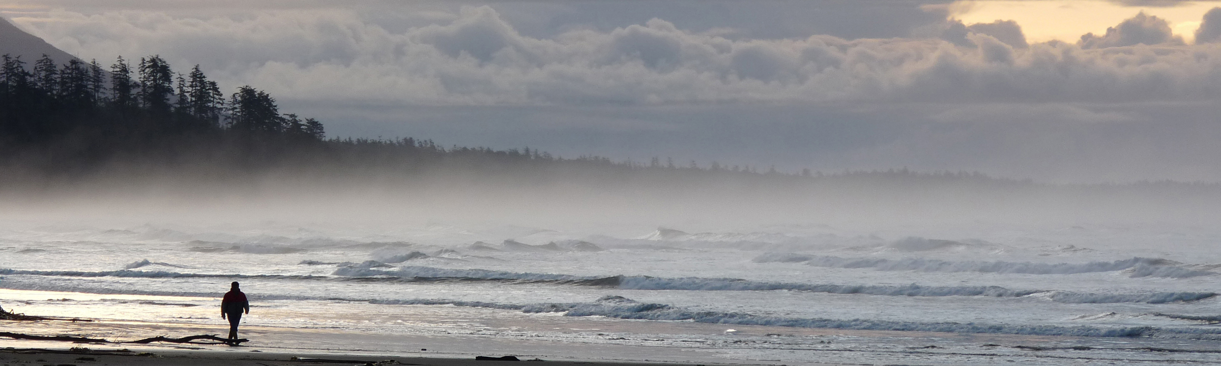
Towering cedars and spruces rise above, the iconic West Coast Trail unwinds ahead. Rugged coastline alternates with lush rainforest interspersed with bridges and ladders. On your way you encounter a myriad of tide pools and waterfalls, you are greeted by graceful deer and colonies of seals, you see eagles in the sky and whales in the ocean. Every unturned stone hides something new, every grain of sand has a story to tell. The 47-mile trail was put in place to help the survivors of shipwrecks in the treacherous nearby waters, dubbed the “Graveyard of the Pacific”. Today part of the Pacific Rim National Park, West Coast Trail is considered by many the world’s best coastal backpacking trail—and dares you to embark on an adventure of a lifetime.
Sense the wilderness of one of the world’s best coastal trails
Camp on the beaches and make lasting memories around the campfire
Discover incredible flora, fauna, and the history of the Pacific Coast
Join your guide and hike through rainforests and Pacific beaches, camp next to waterfalls and sleep under the stars! Backpack for 9 days along a trail combining unspoiled natural wonders—including incredible wildlife sightings—and ingenious man-made structures originally built to help shipwrecked mariners. Enjoy splendid meals, gather round the campfire after daily hikes (sometimes involving lesser-known paths) and fall asleep to the sound of ocean waves.

Start your day at 6 am, pack up and enjoy breakfast. You will first walk to the ferry across Port San Juan to reach the trailhead. The trail in this section is challenging, with lots of roots and an ascent to the highest point on the trail. After hiking for several hours with a lunch break and stops to rest and take photos, you will reach the junction between Camper Bay and Thrasher and descend to Thrasher Cove. One hour later, your group will set a camp, dine on the beach, and gather around the campfire (if permissible) to hear stories about shipwrecks. Meals : Breakfast, lunch, and dinner Hiking : 3.7 miles (6 km) / 5-6 hrs

Pack up and enjoy breakfast before beginning the day. Maneuvering over and around the boulders and pocket beaches, reach Owen Point (tide dependent section). After a break, continue hiking along the sandstone shelf, to one of the forest access points, where your group will stop for a well-earned lunch. Afterward, continue through the lush, rain-forested trail to Camper Bay, where you will cross the river, either by cable car or on stepping stones (depending on the water levels). Before dinner, you refresh yourself in the creek next to the camp. Meals : Breakfast, lunch, and dinner Hiking : 5 miles (8 km) / 6-8 hrs

Start your day with an early breakfast. If the tides are right, you will take a route along the sandstone at sea level, crossing a few surge channels before climbing off the shelf and hiking up the little-known Sandstone Creek to the forested inland trail. Once there, ascend and descend some of the longest ladder sections on the trail—Sandstone and Cullite Creek. After lunch, continue to Logan Creek and the final set of major ladders for the day. Afterward, follow a boardwalk through an upland bog region with many indigenous plants. Continue again through lush rainforest to Walbran Creek, arriving in the late afternoon. Take a dip in the inviting creek pool by the camp before a warm drink, hearty dinner, and great campfire stories. Meals : Breakfast, lunch, and dinner Hiking : 5.6 miles (9 km) / 7-10 hrs

Start your day later, enjoy breakfast and amble along the beach at a more leisurely pace—the toughest part of the West Coast Trail guided trek is behind you. Stop at Bonilla Point, where you’ll check out the beautiful waterfall and the remains of an old ship wreck. Hike past picturesque sea stacks, across the Carmanah Creek, and toward the remains of Chez Monique, the now closed restaurant. After lunch and a short rest, visit the Carmanah Light Station to view the sea lions and continue for another hour and a half through forest and along the beach to Cribs Creek. Here, you’ll set up camp and dine while watching sea lions and gray whales. Meals : Breakfast, lunch, and dinner Hiking : 6.8 miles (11 km) / 5-6 hrs

Begin your hiking by walking along the magnificent natural rock break wall from Cribs creek, with many tide pools, trying to spot surfing sea lions one more time. You will reenter the forest at Cheewaht Beach, just before the eponymous river. Hike along the boardwalk until you reach the Nitinat Narrows—a quaint restaurant famous for fresh crab. Hike to your next beach campsite, a clandestine wild camping gem. Relax before dinner and listen to amazing stories of bravery, heroism, and struggles of early settlers and First Nations and keep an eye for whale sightings! Meals : Breakfast and dinner Hiking : 7.5 miles (12 km) / 6-8 hrs
Day 7 starts with a hike to the ancient Ditidaht Warrior Camp, where you’ll meet one of the Ditidaht First Nations guardians. Afterward, your group will walk to “Hole-in-the-Wall”, a natural arch, and then on to Tsusiat Falls, where you’ll stop for lunch. After a refreshing dip under the falls, ascend a set of ladders to continue along the cliff tops. Take in the breathtaking views and descend to Klanawa Creek, before taking the last cable car across the pond and arriving at your campsite, where we can often enjoy another refreshing dip before a well-earned dinner. Meals : Breakfast, lunch, and dinner Hiking : 5.6 miles (9 km) / 4-6 hrs

Your hiking today begins with walking along the beach and alternating between inland trail and beach/sea shelf walking, until you reach Tscowis—where you’ll stop for lunch. If the tides are favorable, you’ll make a short side hike (pack free) to the place where the ship Valencia ran aground in 1906, leading to the creation of the West Coast Trail (known back then as Shipwrecked Mariner’s Trail). Afterward, make your way along the beach to Darling River and Michigan Creek. You’ll stay at one of these beautiful beaches for our last night, savoring your experiences of the journey around the campfire with your West Coast Trail hiking guides and fellow hikers. Meals : Breakfast, lunch, and dinner Hiking : 5-6.8 miles (8-11 km) / 4-6 hrs

You will head back to civilization after breakfast, around 7.30 am. Walk the last 7.5 miles (12 km) along a very easy trail to the Pachena Trailhead. The feeling of achievement is intensified as your group walks the final section of the beach trail, leading to the Park office and trailhead. Celebrate the successful completion of the West Coast Trail guided tour with fellow hikers, take photos, and check out the trail. On most tours, your group will be met by the bus driver, waiting for you with a delightful lunch with lots of fresh vegetables and fruits. Get back to Nanaimo, say goodbye to your guides, fellow hikers, and Vancouver Island—or continue touring on your own. Meals : Breakfast Hiking : 7.5-8.7 miles (12-14 km) / 4-6 hrs

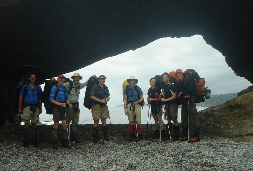
Meet your guides
We did the west coast trail and had the best experience. The guides were excellent, the food was very good, and we felt fully taken care of at all times. Made the trip exceptional. Highly recommend!
Had a great experience with Coast Bliss on the West Coast Trail. The guides were invaluable in making sure we didn’t get into trouble with the tides. Some areas become impassable. And even getting across some of the chutes really needed their expertise. The highlight was likely hiking up Sandstone Creek. This is a very rare event and you really have to know what you are doing. Only a small portion of hikers have managed to go this route.
Just finished the West Coast Trail trip with Coastal Bliss. I would 10/10 recommend this company, we had an amazing experience. Gary and Travis went above and beyond to take care of our safety and made sure that we had a good experience. We trained hard for the trip but were not experienced back country trekkers, so we really appreciated the knowledgeable support of our 2 fabulous guides. They took care of the transportation logistics, tide planning (SUPER important and not easy), showed us how to navigate all the WCT obstacles and cooked for us. We got to experience things on the WCT we would never had been able to do on our own, and Travis’s food was SO good. Added bonus – they were excellent company and we really bonded with our fellow group members – no regrets, already planning my next trip 🙂
All the stuff we got to see and do because of the guides. Also the food was amazing… we were well fed. The beach camping was great. Loved listening to the ocean at night! Our guides kept us going and taught us a lot about hiking, the trail, how to pack and wear a backpack properly. SHIMING is one of the most incredible and kind souls snd his knowledge of the outdoors is unreal!! I met a great group of wonderful people, learned a lot, worked hard, and had a ton of laughs. 100% recommend Coastal Bliss and doing this trail guides for sure.
Thanks for the best trip!!
Coastal Bliss owners and guides have the skills and experience to safely guide you to and through the West Coast Trail — including a few little-known spots. They also have heart and wisdom to inspire respect for the living history and wild soul of the legendary trail. I highly recommend their services and am grateful for this remarkable experience.
What you get on this adventure:
- An experienced, local hiking guide with extensive knowledge of the area
- 9-day West Coast Trail hiking adventure (8 days of hiking)
- Transportation to and from Nanaimo
- All park and camping fees
- Communal camping gear
- Meals as indicated in the itinerary
- Tent (shared)
What’s not included:
- Transportation to Nanaimo
- Accommodations in Nanaimo before and after the adventure
- Meals on travel days (first and the second half of the last day)
- Cancellation and evacuation insurance (mandatory)
- Camping/backpacking equipment (can be rented)
- Guide gratuities — optional
To participate in the West Coast Trail hiking tour, you have to be in very good physical shape. You will be backpacking for 7 days, with daily hiking lasting for up to 10 hours (usually between 4 and 6 hours) while carrying a loaded backpack. You should have previous multi-day trekking experience, but you needn’t necessarily have experience with camping and backpacking. You should be able to climb ladders and endure some ascents and descents in tough terrain with many roots and rugged coastal features. Keep in mind that you will take many breaks during your hikes and that you will always have a guide by your side during your West Coast Trail hiking trip to help you in any aspect of trekking or camping.
Here’s a list of the equipment you need to bring:
- Backpack (at least 60L capacity — can be rented)
- Gaiters (can be rented)
- Full rain gear (including waterproof rain jacket)
- Hiking boots
- Sleeping bag appropriate for cool weather (can be rented)
- Sleeping pad with closed cell foam (can be rented)
- Hiking poles — optional
- Water bottle or hydration bladder (2L capacity)
- Some cash to spend in restaurants along the way
- Water shoes (no flip-flops, crocs are fine)
- Hiking pants/shorts
- Hiking shirts (one is enough)
- Lightweight jacket/fleece
- Socks and underwear
- Swimwear — optional
- Spare dry clothes to wear in the tent (underwear, one shirt, one pair of pants and socks)
- Lightweight bowl (plastic works best), spoon, fork, insulated mug
- Headlamp/flashlight
- Bandages/plasters, blister bandages/plasters, tensor bandage
- Duct tape (not the entire roll!)
- Medications (plus some extra if they are life-saving)
- Toothpaste, toothbrush, toilet paper, some biodegradable soap/shampoo
- Wool or fleece hat
- Headlamp or flashlight
- Camera — optional (but recommended)
Dress comfortably and for the weather in clothes you can move in. We suggest bringing clothing appropriate for the season. Layers are best and don’t wear jeans.
Group sizes and prices:
- For this group adventure, the maximum client-to-guide ratio is 5:1.
- It takes at least 4 clients for the tour to run.
- The cost does not decrease as the group grows.
Hiking along the West Coast Trail can be arranged for larger groups. Contact us to make arrangements.
Min. age requirements:
- If you are older than 18, you’re good to go.
- Minors younger than 18 may be permitted to join the hike on a case-by-case basis, but must be in the presence of a parent or legal guardian.
If your group has hikers under the age of 18 , contact us prior to booking to make arrangements.
To get to Nanaimo on Vancouver Island, where your tour starts, most people fly into Vancouver International Airport which is 2.5 hours away. From there, you can rent a car or take a shuttle service (bus and ferry).
You will meet your guide at Departure Bay, downtown Nanaimo, or Duke Point between 8 and 9 am (specific time will be confirmed the day before the tour starts).
57hours is committed to providing safe outdoor adventure experiences. We require all guides using our platform to have a COVID-19 safety plan and to make the details of that plan accessible to travelers. In most cases, group sizes will be reduced, guides will avoid overcrowded locations, and other safety measures will be met depending on the location and activity.
We also expect clients to respect local regulations and take measures to protect themselves, guides and the communities they’re traveling to. For more information on COVID-19 measures on Vancouver Island, British Columbia, please refer to British Columbia’s Travel and COVID-19 website .
Please contact us if you have any questions or require further information. We are happy to provide you with the most up-to-date information!
Secure your spot for 2025 with a 10% deposit! This tour gets sold out very quickly, but with early-bird booking, you’ll be the first one to know. Pick the month that suits you best and we’ll let you know once the dates are live—don’t risk missing out on your bucket list adventure!
- Only 10% of the total amount should be paid as a deposit upon booking. This deposit is non-refundable, but can be transferred to another 57hours adventure in case the dates don’t suit you by the end of the year.
- Once the set dates for the following season are live, you can confirm your booking by the end of this year by paying another 20% of the total amount.
- The final balance is due 3 months (90 days) prior to departure.
For set dates, a 30% non-refundable deposit to secure your place is due upon booking. The remaining amount is paid 2 months (60 days) prior to departure. Please keep in mind that the tour will not operate with less than four clients . Departures will be guaranteed 60 days prior to departure at the latest.
- If a trip has less than four bookings at the 60 day mark, it will be cancelled and Client is entitled to a full refund.
- If Client cancels the Booking anytime prior to sixty (60) days in advance of the trip contemplated by the booking, Client is entitled to a full refund, less the deposit.
- If Client cancels the Booking within sixty (60) days of a guaranteed departure, Client is not entitled to any refund to ensure that the costs of running the trip are covered.
- If final payment is not received by 60 days prior to the departure date of your registered trip, Guide reserves the right to treat the reservation as canceled. Both deposit (less a $50 administrative fee), and full balance of payment will be refunded if we can replace your spot with another participant after all other spots have been filled.
Other things to do in British Columbia

Backpacking the Nootka Island Trail in BC
View all (52) adventures in British Columbia
Choose a currency
- USD - $ US Dollar
- EUR - € Euro
- AUD - AU$ Australian Dollar
- CAD - CA$ Canadian Dollar
- GBP - £ British Pound Sterling
- CHF - CHF Swiss Franc
- JPY - ¥ Japanese Yen
- SGD - S$ Singapore Dollar
- HKD - HK$ Hong Kong Dollar
- DKK - Dkr Danish Krone
- NOK - Nkr Norwegian Krone
- SEK - Skr Swedish Krona
- Discover the Mountains
- Full Moon Hikes
- Hiker Summit Series
- Hiking Series
- Snowshoe Series
- Women's Summer Solstice Hike
- Private Day Hikes
- Larch Day Hiking Trips
Iceline Trail
Remote backpacking.
- Rockwall Trail
- Women's West Coast Trail
- West Coast Trail
- Private Multi-Day Trips
- Women's Backpacking to Diana Lake Lodge
- Navigation Course
- Women's Intro To Backpacking
- Women's Intro to Winter Camping
- Women's Next Step
WEST COAST TRAIL
The hike of a lifetime.

- Trip Description
- Dates & Bookings
- Itinerary & Gear
Dates and Bookings
Adventure Dates 2024:
Women's only - SOLD OUT!
Eight spots left!! - Have a private group and want to book!!
Have a group of friends who want to get out? We can put together a private trip just for you! Reach out ahead of November for your private trip to run the following summer.
CAD $2300 + applicable taxes
- Information package will be given upon registration
- We value small groups - limited to 8 adventurers
Searching Availability...
Itinerary and Gear
Planned itinerary.
- Day 1: Today is for the pre-trip meeting only. Meet the group at 6 pm at the Royal Scot Hotel. We will make sure everyone has everything they need, introduce the group, go over the trip plan, laugh lots, and distribute the group gear.
- Day 2: We'll wake up early, full of energy, and catch our shuttle to the trailhead. After a 2.5 hr drive on a very winding road we will attend a short orientation at the Parks Canada Office in Port Renfrew before catching the ferry to the start of the trail. The trail is challenging right from the start as we face one of the steepest ladders on the trail. After 6km of rough, muddy, and unforgiving terrain we arrive at Thrasher Cover, our home for the night - 6km.
- Day 3: Coffee delivered to your door?! What else could you want? After a delicious breakfast we will start our most challenging day. Crawling over boulders, driftwood, and negotiating surge channels are the theme for the day. We chose hiking dates that allow us to hike along the beach for this section so we can enjoy the famous Owen's Point. Although challenging, you will love the views. Campers Bay will be where we will lay our heads for the night - 8km.
- Day 4: Day 3 - Scream with excitement as we experience our first cable car crossing. Or, maybe scream when you see the two longest ladders of the trail? Today will be a challenge with those who struggle with heights as we also cross the Logan Creek suspension bridge. Wahoo!! Talk about stepping outside ones comfort zone! After a full day of engagement we will spend the night at Walbran Creek - 9km.
- Day 5: So cool! Today is the quintessential West Coast Trail. Often whales can be seen in the distance as we hike along the sandstone shelves. If you're nervous about food, today is your day! Grab a seat and enjoy deliciously large burgers at Chez Moniques. We will also pass Carmanah Lighthouse where the Pacific Ocean meets the Strait of Juan de Fuca. It is a great location for watching sea lions! With full bellies we will waddle into Cribs Creek for the night - 11km.
- Day 6: OK, time to strap on those hiking boots and pull up our big kid pants. We have 17km to hike! But we are thoroughly rewarded by finishing our day at Tsusiat Falls. Here we will find a natural swimming hole. But don't worry we have many rewards along the trail as well. Enjoy fresh seafood at Nitinat Narrows. We will also experience our second ferry of the trip. The boat crossing operated by the local First Nations people. The last portion of the day’s hike will be along coastline and if possible, through Hole in the Wall at Tsusiat Point - 17km.
- Day 7: Today we start the day with ladders back to the trail, through rainforests, and often muddy ground. But don't worry, you can eat the majority of your food because we only have ONE more day of hiking, yippee! Our destination for the day is Michigan Creek - 13km.
- Day 8: Don't shed tears. It has been a wonderful trip, but sadly, it is our last day. We finish off with the easiest hiking of the entire trail. Pachena Lighthouse will provide us with our last opportunity to see some sea lions and we only have one set of ladders yet to go, at the very end! Our shuttle will be waiting for us as we shout for glee in honour of our accomplishment - 12km...75km in total! Huge congrats!
Level of Difficulty
This trip is trip is not for the faint of heart. Rough terrain, mud, ladders, suspension bridges, and cable cars create this trip. Physical training is required prior to completing this trip. Follow our 6 week hiking fitness program to help set you on the right path. We recommend completing it twice, 12 weeks. However, we also recommend partaking in our Hiking Fitness Series to help prepare your body for the physical demands of this backpack. You should be able to carry ~40 lbs (~18 kg) for up to 8 hours.
If you are not physically ready for this trip, placing yourself and others at increased risk, the guide does have the right to remove you from the adventure. Investing in physical training is key in having a successful trip.
With the right physical preparation you will love this trip! There is a reason why it is ranked #5 in the world!
6 week hiking fitness program Hiking Fitness Series
Have questions, don't hesitate to contact me . I am here to help!
Gear, Food and Lodging
- Wilderness pass for each night
- Tents for camping - we prefer people from the same "bubble" share tents as some campgrounds have limited tent platforms. Strangers will not be paired together unless requested to help decrease pack weight
- Amazingly delicious food from supper on day 1 to lunch on the last day
- The expertise from an ACMG Guide
- All group gear - stove and pots, food storage materials, sunblock, bug spray, water treatment, and first aid kits
- All safety equipment - bear spray, first aid kit, emergency communication device, and tarp
- Roundtrip transportation to the trailhead from Victoria
- Boat shuttles along the Trail
Participants must provide:
Accommodations the night before getting on the trail - We recommend R oyal Scot Hotel & Suites
- Transportation to the Victoria
- Lunch on the first day and supper on the last day
- Personal Gear (Can be arranged for an additional fee) Personal Gear List
Optional Reading
- West Coast Trail Map
West Coast Trail Challenges
Inspiration

You Might Also Like...

Hiking Fitness Series
Train your body for summer adventures! Learn to how modify your step to save energy, manage those aches and pains, and stay injury free.

This Canadian Rockies trail is a world-class trek. With the third day above tree line, you will not believe the views. Ranking top 10 in Canada, the iceline trail is Yoho's most scenic trail
West Coast Trail
Sea to Sky has introduced hikers to the West Coast Trail for 30 years. Our years of experience will insure that your visit will include all those special places unknown to the average hiker.The West Coast Trail is a challenging coastal trek. Known also as the "Graveyard of the Pacific", it is rich in human history, wildlife, and natural rugged beauty, and is considered one of the world's top ten hikes. Once you start hiking, you will quickly come to understand why hikers travel from all over the world to undertake the West Coast Trail.
The West Coast Trail offers sandy beaches, rugged cliffs, blowholes, caverns, caves, waterfalls, bogs, rainforest, lighthouses, abandoned settlements, shipwreck relics, native culture, whales, sea lions, eagles, and giant trees. With over 35 years of guiding on the trail —the longest of any company—our West Coast Trail itinerary includes stops to see things other companies can't offer. We point out historic and scenic wonders unknown to many hikers. Our pace allows time to adjust to the demands of the trail and to fully see and explore this magnificent Coastal Environment. Readings and anecdotal stories help the hiker fully appreciate the dramatic and colourful history of the events and people who were—and some still are—a part of this coastline. We have arranged a food drop for the half way point in our hike, thus reducing the weight carried by each hiker. Our starting point is Nanaimo , on Vancouver Island, because it reduces travel times to and from the trailheads, getting you back to your hotel or transportation earlier on the last day. With an international airport, and service by two ferry terminals coming in from the two Vancouver area terminals, Nanaimo is more accessible than Victoria . We pick up from downtown hotels and the ferries, and from there, everything but travel food is provided (you provide your own personal gear). We have been leading groups on the West Coast Trail longer than any other tour company on the trail, so we know the ins and outs, the history and the secrets, and have built a strong and respectful relationship with the First Nations on the trail.
See our Detailed Hiking Trail Rating System
THE SEA TO SKY ADVANTAGE
Small groups.
Greater access to your expert local guide for a more intimate and personalised experience.
35+Years Experience
Thousands of delighted guests with many returning for more. Experience the Sea to Sky difference and find out why.
Certified Guides
Enthusiastic and knowledgeable, our guides offer invaluable source of information on local culture, history and sights making your trip one of a kind.
Dates and Prices
We know the range of dates we are requesting from Parks, but won't have confirmation of any dates until December, 2023.
West Coast Trail 2024 Confirmed Dates
Every year in September/October, all guiding companies request dates from Parks Canada for the West Coast Trail for the following summer. We request 1st, 2nd and 3rd choices for start dates for each trip. The three start date choices sets the range that the trip should fall within. This year, we got the date confirmations on December 5th. These are our confirmed dates for 2024
May 20-28, 2024 - $2395 + 5% FULL
June 2-10, 2024 - $2395 + 5% 3 spaces available
June 18-26, 2024 - $2395 + 5% 6 spaces available
July 2-10, 2024 - $2395 + 5% 1 space available
July 22-30, 2024 - $2395 + 5% FULL
July 31-August 8, 2024 - $2395 + 5% FULL
August 16-24, 2024 - $2395 + 5% FULL
If your date choice above is not available, you can try dates with Coastal Bliss Adventures . The dates below are Coastal Bliss dates and availability.
June 4-12, 2024 - $2395 + 5% 1 space available
June 20-28, 2024 - $2395 + 5% FULL
July 4-12, 2024 - $2395 + 5% FULL
July 20-28, 2024 - $2395 + 5% 1 space available
Aug 2-10, 2024 - $2395 + 5% 1 space available
August 18-26, 2024 - $2395 + 5% 2 spaces available
September 2-10, 2024 - $2395 + 5% 4 spaces available
SOUTHBOUND! September 15-23, 2024 - $2395 + 5% 1 space available—Starts at Pachena Bay, travels south
North Coast Trail* 2024 Dates
June 5-13, 2024 - $2,449 + 5% 7 spaces available
August 16-24, 2024 - $2,449 + 5% 8 spaces available
*Available through our sister company, Coastal Bliss Adventures.
Cape Scott Trail* 2024 Dates
June 17-22, 2024 - $2,104 + 5% 4 spaces available
August 16-21, 2024 - $2,104 + 5% 4 spaces available
South Chilcotins 2024 Dates
The South Chilcotin Mountain tour has been significantly changed over the last several years due to 3rd-party service changes and the Downton Lake fire of 2023. This is a STRENUOUS backpacking trip due to big elevation changes, but it is doable for someone with reasonable fitness, and well worth it for the spectacular views.
July 4-10, 2024 - $2349 + 5% 8 spaces available
*August 1-7, 2023 - $2349 + 5% Inquire
Nootka Island Trail* 2024 Dates
June 16-21, 2024 - $2,304 + 5% Inquire
July 16-21, 2024 - $2,304 + 5% 5 spaces available
July 27-August 1, 2024 - $2,304 + 5% 7 spaces available
August 25-30, 2024 - $2,304 + 5% FULL
Tombstone Mountains Hike 2024 Dates
July 12-17, 2024 - $2,994 + 5% 4 spaces available
July 25-30, 2024 - $2,994 + 5% 1 space available
August 9-14, 2024 - $2,994 + 5% FULL
August 26-31, 2024 - $2,994 + 5% 2 spaces available
*Unfortunately, Yukon Parks has decided to have the opening for reservations at the beginning of March. We can usually get our dates, but we can't guarantee them. This area has become more and more popular, so it is getting harder to secure all the dates we want in a season.
Tombstones Base Camp Fly-in/Fly-out 2024 *Date Ranges
July 28-August 2, 2024 - $4,159 + 5% Inquire
August 17-22, 2024 - $4,159 + 5% FULL
Arctic Circle Drive & Hike 2024 Dates
July 28-August 2, 2024 - $2,399 + 5% Inquire
August 26-31, 2024 - $2,399 + 5% Inquire
September 5-10, 2024 - $2,399 + 5% 7 spaces available
Kluane Base Camp 2024 Dates
July3-9, 2024 - $2,599 + 5% Inquire
August 17-23, 2024 - $2,599 + 5% 3 spaces available
August 27-September 1, 2024 - $2,599 + 5% FULL
Rainbow Range 2024 Dates Coming Late Spring This Trip Is In The Middle Of The Permitting Process
June 24-28, 2024 - $2,259 + 5% 10 spaces available
July 14-18, 2024 - $2,259 + 5% 10 spaces available
August 30-September 3, 2024 - $2,259 + 5% 10 spaces available
Chilkoot Trail 2024 Dates
The US side of the Chilkoot Trail remains closed for 2024.
July 3-9, 2024 - $2,349 + 5% Not available
July 17-23, 2024 - $2,349 + 5% Not available
August 7-13, 2024 - $2,349 + 5% Not available
August 21-27, 2024 - $2,349 + 5% Not available
Broken Group Islands 2024 Dates
(4 days) June 10-13, 2024 - $1,684 + 5% *3 spaces available
(4 days) July 2-5, 2024 - $1,684 + 5% *8 spaces available (Family friendly trip)
(6 days) May 22-27, 2024 - $2,194 + 5% *Inquire
(6 days) July 15-20, 2024 - $2,194 + 5% *8 spaces available
(6 days) July 27-August 1, 2024 - $2,194 + 5% *8 spaces available
(6 days) August 6-11, 2024 - $2,194 + 5% *8 spaces available
August 15-18, 2024 Private Tour *Not available
*The number of spaces may depend on paddlers' experience and kayak type. We have strict guide-to-client ratios that dictate the available spaces.
Johnstone Strait 2024 Dates
7 day tours $2,349 + 5%.
July 8-14, 2024 - $2,349 + 5% tax *Inquire
July 30-August 5, 2024 - $2,349 + 5% tax 5 spaces available
August 11-17, 2024 - $2,349 + 5% tax *Inquire
August 23-29, 2024 - $2,349 + 5% tax 6 spaces available
Broughton Archipelago 2024 Dates
May 27-June 2, 2024 - $2,349 + 5% 1 space available*
June 22-28, 2024 - $2,349 + 5% *Inquire
July 8-14, 2024 - $2,349 + 5% *Inquire
July 19-25, 2024 - $2,349 + 5% *Inquire
August 23-29, 2024 - $2,349 + 5% *Inquire
*The number of spaces may depend on paddlers' experience and kayaks. We have strict guide to client ratios that dictate the available spaces.
Bowron Lakes 2024 Dates (confirmed)
June 13-20, 2024 - $2365 + 5% Inquire
July 3-10, 2024 - $2365 + 5% Inquire
July 22-29, 2024 - $2365 + 5% 4 spaces available
August 5-12, 2024 - $2365 + 5% Inquire
August 19-26, 2024 - $2365 + 5% Inquire
September 6-13, 2024 - $2365 + 5% Inquire
Turner Lakes Canoeing Recon Trip 2024 Dates This Trip Is In The Middle Of The Permitting Process, so it is a special scouting trip available to alumni only
August 29-September 3, 2024 - $1844 + 5% Spaces available
Turner Lakes Canoeing & Hiking Recon Trip 2024 Dates This Trip Is In The Middle Of The Permitting Process, so it is a special scouting trip available to alumni only
July 13-19, 2024 - $2149 + 5% Spaces available
Yukon River Canoeing 2024 Dates
July 16-25, 2024 - $2799 + 5% 8 spaces available
August 3-12, 2024 - $2799 + 5% Inquire
August 17-26, 2024 - $2799 + 5% 4 spaces available
Teslin River Canoeing 2024 Dates
June 21-29, 2024 - $2619 + 5% Inquire
July 4-12, 2024 - $2619 + 5% Inquire
August 16-24, 2024 - $2619 + 5% Inquire
Book Your Trip
Searching Availability...
Nanaimo, Vancouver Island Nanaimo is a good choice if you are looking for less travel time on the first and last day of the trip. Nanaimo acts as the link that "closes the loop" for our trip, it is the perfect pick up and drop off location. Also a good choice if you are planning to stay on Vancouver Island. **Pick UP** – The ferry from the mainland will land around 10am. The Guide team will do a first pick up at the ferry terminal at 10:30am, followed by a Nanaimo hotel pick up between 10:30-11am. The ferry crossing from Horseshoe Bay to Departure Bay on Vancouver Island is approximately 1.5 hours. We are on our way to a mandatory Parks Canada Orientation which everyone must attend in order to do the WCT. From Departure Bay, it is about two and a half hours to Port Renfrew. After registering at the trailhead office, we will stay in Port Renfrew. We will be camping on the beach and learning how to set up our tents for the first time. Your guide team will then take the time to do a final 'pack check' with everyone to ensure that you have everything you need (but also not too much of what you think you need!). The time will be used to get to know our traveling companions and discuss the trail ahead.
We will return to the West Coast Trail registration office and be transported across the Gordon River by boat to the trailhead. Our destination is Thrasher Cove. Although just 6 km away, the terrain is such, that it will take us most of the day. There are no scenic rewards other than those provided by the forest, creeks and occasional waterfall. You will sample your first set of ladders and see a donkey engine, used for logging the local forest in the early 1900s. Thrasher Cove presents your first opportunity to enjoy beach camping. Although a small cove, it provides water and an excellent view of Port San Juan and Port Renfrew across the water.
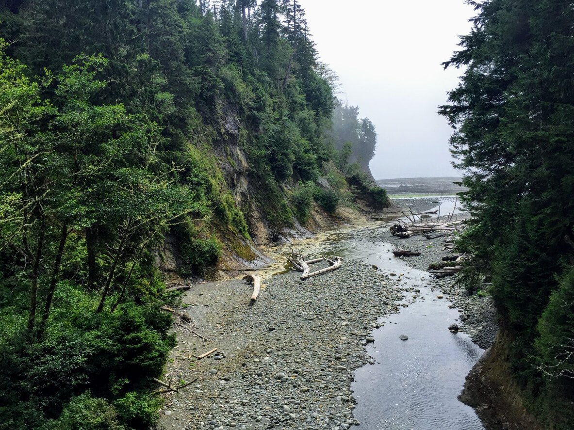
The morning tide will determine whether we will follow the beach to Owen Point or return to the trail. The beach hike, although characterized by huge boulders, is more scenic and varied than the trail. The shelf near Owen Point has sandstone bluffs, caves and caverns, unusual rock formations and surge channels. Many hikers believe it resembles a moonscape. We will eventually leave the shelf because of impassable headlands and sample the beauty and denseness of a west coast rain forest. Camper Bay is our destination. The campsite is located by a creek and flanked by magnificent sandstone bluffs.
Our day will once again be spent in rain forest. Although this is a difficult and usually muddy section of the trail, it offers an opportunity to really appreciate the lush, vibrant beauty of a rain forest. Or we may be lucky enough to traverse one more amazing sandstone shelf, tide willing, on our way to Sandstone Creek. At Sandstone and Cullite Creeks we will encounter another series of ladders. From Cullite Creek we will pass along a boardwalked bog that features some interesting flora, including stunted cousins of hemlock, spruce and cedar. At Logan creek we will cross the WCT's largest suspension bridge. Our campsite is Walbran Creek. We now leave behind the most difficult section of the trail and begin that section characterized by mostly beach and shelf hiking.
Today will be a shorter, more restful day. Primarily on the beach, this day's hike will be a welcome change from the challenges of the forest. At Bonilla Point we will see the Carmanah Lighthouse in the distance. Today we will pass a special spot on the beach which was, until recently, the location of Chez Monique's. Sadly both Monique and her husband, Peter, have passed and the legendary food shack has been forced to close. Your guide will be happy to recall many tales from past visits with Monique who was well-known for her generous and gregarious nature. Her daughter Sandy and her family kept the oasis open one last year in 2018 to honour her parents. Next we will visit Carmanah Point Lighthouse; perched on top of the cliffs like a castle, Carmanah offers breath-taking views of the surrounding area. Below the lighthouse is a rock favoured by sea lions. Our camp tonight is at Cribs Creek, the Cribs being a geographic feature making a natural breakwater, with many tide pools to explore.
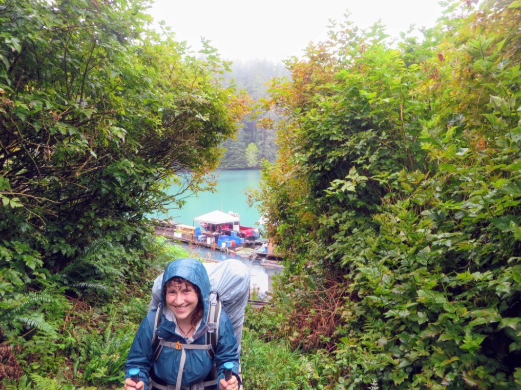
Depending on the tide, we will likely hike the "beach" again. This section of hard packed sand, imposing cliffs and some of the most unique and varied sandstone rock shelf formations makes for very enjoyable hiking. We will descend to a beautiful sandy beach near the Cheewhat River. After crossing the Cheewhat River we will re-enter the rainforest (where you'll really notice the difference in the type of trail compared to the first three days). Stopping at Clo-oose for a short rest, we continue on to Nitinaht Narrows and the Crab Shack. The Narrows, because of its depth and current, must be crossed by boat with the assistance of the local First Nations. Carl and Shelley Edgar and their family have been operating the "Crab Shack" here for many years. We will stop here for a filling crab and fish lunch before we cross the narrows and continue on to our camp at Barge Beach. We will also pick up the remainder of our food for our last part of the trail at the narrows.
The section of trail from our camp past the Narrows to Tsuquadra Beach is considered by many to have the most spectacular views. We will stop to explore the remnants of the Didadaht village from the turn of the century. Old lodge poles stand in solemn tribute to the memory of these hardy coastal people who once inhabited the site. Soon after leaving thevillage site we will arrive at Hole in the Wall, a wave worn hole cut into the rock at Tsusiat Point. An old Ditidaht legend states that "… those who pass through Hole in the Wall have passed through Hole in the Wall." Tsusiat Falls is just up the beach, where we will stop for a leisurely lunch and swim below the falls. Tsusiat Falls is considered by many to be one of the major highlights of the trail. After our lunch break, we will continue on the next few kilometres to Klanawa River for our camp.
Leaving the Klanawa River, we will follow the beach until Trestle Creek and then head into the forest. We will stop where the trail overlooks the shelf. In 1906 the S.S.Valencia went aground here in a violent storm. The battering waves eventually broke the ship apart and 126 passengers and crew lost their lives. This tragic event was the catalyst for creation of the West Coast Life Saving Trail which would later become the West Coast Trail. Returning to the trail we will cross two suspension bridges, stopping at Tsocowis Creek for lunch. It is all beach and shelf to our campsite at Michigan Creek.
With the exception of a visit to Pachena Lighthouse, and perhaps at Sea Lion Rock, our last day on the trail will be uneventful. From Michigan Creek the trail will be entirely through rainforest. The route follows the section of the West Coast Lifesaving Road that was completed, and wider than the trail from days before. It is considered the easiest section of the trail. The end of the trail is at Pachena Bay. We should be there by around noon. We will drive to Port Alberni-on the now chip-sealed road-for lunch and then on to the Departure Bay ferry terminal in Nanaimo. We should arrive at the ferry terminal by late afternoon with the intent to catch the early evening ferry back to Horseshoe Bay or your accommodation in Nanaimo.
inclusions and exclusions at a glance
- Transportation from the point of origin and return
- Snacks/beverages on the expedition
- All meals while on the backpacking portion **
- Meal preparation
- National Park Backcountry Camping and Permit fees
- Trail ferry fees
- Exceptional guides for entire journey
- Cooking gear/camp stoves/water filtration
- Tents & tarps
- Emergency radio/satellite phone/major first aid supplies
- † We can provide sleeping bags, sleeping pads, backpacks, poles for rent
** You will be responsible for food you may want at the Nitinaht Crab Shack
- Transportation to point of origin, transfers, personal equipment, accommodation and food other than included in the itinerary.
- National Park Entry Pass (although this can be purchased for a single park, a National Parks Discovery Pass, individual or family, meets this requirement. If you already have a NP Discovery Pass, you will need to bring it and present it.)
- Gratuities are not included. Our guides make every effort to ensure your holiday is all you expected and more. Recognition of a job well done is always appreciated; $10-20/day per guide is recommended.
- Single tents † (available for a single supplement charge)
Vancouver Many of the major North American carriers fly into Vancouver or alternately, Seattle. Check with your travel agent for options. There is a bus service, Quick Shuttle , from Seattle's airport to hotels in Vancouver. These run daily and are reasonably priced. For more information, in North America, phone 1/800/665-2122 or 1/604/940-4428 – Fax 1/604/940-4429. Check the link regarding shuttles and other airport information.
Nanaimo Several bigger carriers fly into Nanaimo, usually after a change in Vancouver. Check with your travel agent for options that take you all the way to Nanaimo. Alternatively, the Horseshoe Bay ferry in West Vancouver sails to Departure Bay, Nanaimo. The Tsawwassen ferry terminal also has sailings to the Duke Point ferry terminal in Nanaimo.
Nanaimo The following hotels are recommended accommodations and are pick up locations. Naniamo Pick up & Hotels Pick up: Departure Bay, Duke Point Ferry Terminal, or the following Accommodations: Days Inn Harbour View Nanaimo Address: 809 Island Hwy South, Nanaimo, British Columbia, Canada, V9R 5K1 Phone (250) 754-8171 Website: www.nanaimohotel.com Best Western Dorchester Hotel Address: 70 Church, Nanaimo, British Columbia, Canada, V9R 5H4 Phone: (250) 754-6835 Website: www.dorchesternanaimo.com Painted Turtle Guesthouse Address: 121 Bastion Street, Nanaimo, British Columbia CANADA, V9R 3A2 Toll Free: 1-866-309-4432 Phone: (250) 753-4432
- What kind of footwear is suitable?
- What kind of backpack is suitable?
- Should I use hiking poles?
- How much weight will I need to carry?
- How much of a tip or gratuity for guides is reasonable?
This is a rugged hike for some portions. The best boots for this kind of backpacking are solid-able to take rough talus slopes, water proof, and with a full, stiff shank for ankle support. If you get new boots, it is important to break them in before your trip to ensure that they are comfortable and to minimize the risk of blisters. It is also a good idea to bring a pair of comfortable sandals or water shoes for wearing around camp and for crossing streams or other bodies of water.
For a multiday backpacking trip in varied terrain, you will want a backpack with a capacity of at least 65-85 liters, depending on the size of your gear and the type of trip you are taking. Some key features to look for in a backpack for this type of trip include: Comfort: Look for a backpack with a comfortable and well-padded hip belt and shoulder straps, as well as a good ventilation system to prevent your back from getting too hot and sweaty. Durability: Choose a backpack made from strong and durable materials, such as ripstop nylon, to withstand the rigors of the trail. Weather resistance: Consider a backpack with a waterproof or water-resistant cover or built-in rain cover to protect your gear from the elements. Load-carrying ability: Look for a backpack with a sturdy frame and good load-carrying capacity to support the weight of your gear. Organization: Choose a backpack with plenty of pockets, compartments, and attachment points to help you keep your gear organized and easily accessible. Size: Make sure the backpack fits you well and is the right size for your body and your gear. It is also a good idea to try on a few different backpacks and load them with weight to get a feel for how they carry before making your final decision.
Hiking poles can be a helpful tool for a rugged backpacking trip, as they can provide additional support and stability on rough or uneven terrain. They can also help to reduce the impact on your joints and muscles by distributing some of the load to your upper body. However, whether or not to use hiking poles is ultimately a personal decision, and it may depend on factors such as your physical abilities, the terrain you will be hiking on, and your personal preference. Some people find that hiking poles help them to maintain balance and reduce fatigue, while others prefer to hike without them. If you do decide to use hiking poles, it is important to choose a pair that is comfortable, lightweight, and adjustable to your height. It is also a good idea to practice using them before your trip to get a feel for how they work and to ensure that you are using them correctly.
You can expect to carry up to 40 lbs, depending on the gear you bring. (about 18.2 kg) We pack and prepare the food, usually about 7 to 9 lbs (3.2 to 4.0 kg) for this 9-day trip. We also share out the group gear. We are also supplying the tents, which typically weight 4 to 6 lbs., depending on whether they are double or single tents (double occupancy is standard, singles require a supplemental charge). Double tents are split between guests, so usually contribute about 3 lbs. to pack weight. Altogether, expect to be given about 12 to 14 lbs. (5.4 to 6.4 kg). If you want your pack weight to be 35 lbs. (15.9 kg) or less, then your backpack and gear that you bring, along with 2 Litres of water, can only weigh up to 20 lbs. (9 kg). This is a strenuous trip, with ladders and sections up and over headlands along the rugged coast. We do build in having a food drop along the way, and a lunch at the Crab Shack, so we carry less food than a normal 9-day trip. It is still strenuous, and you should expect to train and prepare for this hike.
Tips, or gratuities, are not mandatory. However, please consider what service is actually being given to you. While you might think that the company should just pay the guides better, it is not so simple. We do work in a competitive market, and pay rates are a function of the trip prices. If we could double prices, we would pay guides significantly better. At Sea to Sky, we have some of the better pay rates in the industry, and we are always pushing our competitors to increase pay rates for guides, but there is only so much we can do. Guides are seasonal workers. They shift off of their summer season to winter activities, or fill in with retail work, which is usually little more than minimum wage, often to periods of no work between seasonal jobs. It is a hard job, and wearing on the body. The guides carry most of the group gear, so they have heavier loads than you have, all for you, because they would not be carrying much of the extras on a personal trip. Your guides are teaching you, helping you through challenges, cooking for you and serving you your meals, providing a safety envelope for you, and if you have a really good guide, they are filling you up with a deeper experience of being in the place you are visiting by telling you about the flora, fauna and history of the place. So, how much should you tip your guides? If you ate every meal out in a day, at a good, but low-cost restaurant, you would probably tip between $10 and $15 per day. If you were travelling and visiting a city and ate all your meals out, this is about how much you would tip for the day, low end. I would submit that the guides are feeding you all three meals in a day, AND serving you in so many more ways. That makes $10-$15 a day a minimum consideration, really. 10% to 15% of a trip price has been another rule of thumb that has been used. If your trip price is $2000, then $200 to $300 split between the guides is reasonable, and falls within that standard. Like most humans, guides are motivated when they are recognized and valued. Your circumstances matter. If you are a student and clearly struggled to put together the cost of the trip, or have other circumstances that limit your ability to tip, guides understand and honour your appreciation, no matter what the size. However, if you have a large income or high net worth and means, a small tip might be a slap in the face. If you have means and you clearly and vocally appreciated the guides and all they did, and then leave a $50 tip after a 7 to 9 day trip, that amount would probably be insulting. If you have a fairly large income or net worth, you likely spend it on higher end restaurants, and maybe higher cost wine, drinks or desserts. You might even give a $50 tip for a dinner meal out-for ONE meal, so just consider your ability to tip and the level of service you received over the whole trip. The largest tip any of our guides has received from one person is $1,500.00 for a 9-day trip. This was highly unusual, and was because we went way out of the way to replace her boots in the middle of the trail because her boots were falling apart, and was on top of paying for the boots and the transport out to the trail. That was extraordinary service, and an extraordinary tip. On average, guides usually receive about $75 to $125 from each guest for each guide. At Sea to Sky, we also split the tips between the lead and assistant guides, and proportionally with any drivers. We have a strong culture of teamwork and both the lead and assistant guides play essential roles for you, so we ensure both share equally in the tips for the trip. Tips are not shared or taken by owners and managers not on your trip, unless you send it separately and specify it is for service before or after a trip.
For any wilderness adventure, "layering" is one of the most critical concepts. Layering clothing can have several advantages: Temperature regulation: Layering allows you to adjust your level of warmth by adding or removing layers as needed. This can be especially useful in unpredictable weather or in environments with fluctuating temperatures. Comfort: Layering can help you stay comfortable in a range of temperatures and activities. For example, if you're going for a hike, you can wear a base layer to wick sweat away from your skin, a mid layer for insulation, and a outer layer to protect against wind and rain. Versatility: Layering allows you to mix and match different pieces of clothing to create different looks and adapt to different situations. Style: Layering can add depth and interest to your outfit, allowing you to express your personal style and create a polished look. Protection: Layering can also provide protection against the elements, such as wind, rain, and cold temperatures.
- All Activities
Adventure Packages
- History & Culture
- Nature & Wildlife
- Hiking & Biking
- Backpacking
- Fly Fishing
- Signature Tours
- Group Tours
- Private Tours
- Family Friendly
- The Guide Hut
- Terms & Conditions
Conservation
- NATURE JOURNAL
©2018 Long Beach Nature Tours Design: Owen Perry
BACKPACKING TRIPS
West coast trail.
World-class trek, private boat cruise through the Broken Islands, abundant wildlife, waterfalls, scenic beach campsites and more. Come and experience this gem of Pacific Rim National Park Reserve with us.
Or call 1-250-725-3320
ALL ACTIVITIES > MULTI-DAY TOURS > BACKPACKING TRIPS
The West Coast Trail, "Hike of a Lifetime" stands out as one of the premier backpacking trips worldwide, and for good reason. This distinctive and demanding coastal route promises a wealth of wilderness experiences for those willing to take on the challenge. Spanning the west coast of Vancouver Island in the beautiful Pacific Rim National Park Reserve, it leads hikers on a pilgrimage through breathtaking rugged coastal terrain and ancient temperate rainforests.
| All-Inclusive Trip - food, gear and guidance all included! | Private boat cruise through the Broken Island Group of PRNPR | World famous trek with expert local guides
TRIP SUMMARY
STARTING AT $2,700 / person
Prices are listed in Canadian Dollars
Duration: 9 days
Starts/Ends: Tofino
Activity Level: Advanced
Group size: 1-4 people
Available Dates: Aug 29-Sept 5, 2024
JOIN THE WAITLIST

WHAT'S INCLUDED
| Meals on the trek (breakfast, dinner, hot drinks) | Professional ACMG certified hiking guide | Group equipment (including tents, sleeping bags, pads, stoves, etc.) | Shuttle from Port Renfrew to Tofino | Park Permits
WHAT'S NOT INCLUDED
| Transportation to Vancouver Island | Hotels or lodging pre/post trip | Personal gear | Lunch and snacks | Trip Cancellation Insurance | Medical and Evacuation Coverage | Guide Gratuities
ROUTE STATS
Hiking Duration: 7 days Per/Travel Days: 2 days Trail Length: 75km Elevation Gain: 1,706m Location: Pacific Rim National Park Reserve Region: West Coast Vancouver Island Rating: Advanced
GUIDE TO GUEST RATIO
We lead treks at a 1:4 guide to guest ratio.
MINIMUM PARTICIPANTS
Please note that a minimum of 4 participants are required to guarantee each trip at the advertised price.
AGE GUIDELINES
We do not accept participants under 16 years old due to insurance and liability reasons.
You will be paired with a certified ACMG Hiking Guide. The ACMG demands the highest entry standard of any Canadian qualification. Its members are among the best climbers, skiers and backcountry experts in the country. ACMG members are also outstanding teachers and coaches who can help you progress your technical competence, mountain sense and risk management skills. Guides and instructors know their terrain and conditions and will help you achieve success by assisting you in choosing the best objectives for the current conditions.
WHEN IS THIS TRIP AVAILABLE?
This backpacking trip is offered only once a year as permits and access are limited. Please reach out to us directly if you are interested in the dates listed above and our team will get back to you right away.
SAMPLE ITINERARY - This is an example of what our itinerary may look like. Weather, group fitness and many other factors may cause the camp locations and the days hiking distances to change.
DAY 1 | ORIENTATION DAY, TOFINO
You will need to arrive at 2:00pm to meet your guide at our office inside Storm Light Outfitters in Tofino. Long Beach Nature Tours will provide you with a detailed PreTrek document upon registration including personal gear list, meeting location and driving directions. Here at our guide hut, your guide will begin the route orientation, discuss the weather forecast, gear check, gear distribution and packing. You will have this afternoon and evening to rest and get any last minute items you may want for the trek ahead starting the following morning as we wont have access to any services after today.
DAY 2 | BAMFIELD & PACHENA BAY
Our day begins early in Tofino where we take the short 30 minute drive to Ucluelet where we meet our boat for a scenic cruise across Barkley Sound and through the Broken Island Group of Pacific Rim National Park Reserve. The tranquil waters of the Broken Group Islands provide a perfect canvas for wildlife encounters, from playful seals to majestic bald eagles soaring overhead. As we approach Bamfield, the quaint charm of this coastal village beckons, nestled between towering evergreens and the endless expanse of the ocean. Here we will taxi to the Pachena Bay campground where we will attend our mandatory Parks Canada briefing that afternoon. Today we will base ourselves at Pachena Bay, practice camp set up, next to the trailhead for the official start of the trail tomorrow. Hiking Distance: 0km Elevation Gain/Loss: 0m
DAY 3 | PACHENA BAY to MICHIGAN CREEK
It's trekking time! We will get an early start today as this will be our first official day on the West Coast Trail. The trail is very well groomed along most of this section. This is one of the easiest sections of the entire hike and a nice warm up for a heavy pack. We will cover some rainforest and coastal sections today along with a visit to the Pachena Point Lighthouse. Hiking Distance: 12km Elevation Gain/Loss: 250m/250m
DAY 4 | MICHIGAN CREEK to TSUSIAT FALLS
After enjoying breakfast, we will break camp and continue south along the trail, with some beautiful rainforest and beach sections, ladders and an exciting cable car crossing of the Kianawa River. At the end of a long day of hiking, we will arrive at the most popular and most beautiful campsite along the route; Tsusiat Falls. Hiking Distance: 12km Elevation Gain/Loss: 410m/470m
DAY 5 | TSUSIAT FALLS to CRIBS CREEK
Today will be the longest hike we will have along the trail, awarded with amazing views and a boat ride across Nitinat Narrows with a well earned hot lunch at the famous Crab Shack where we will rest and enjoy the break and a full belly. Tonight we will make camp at Cribs Creek known for it's unique rock features and bird life. Hiking Distance: 17km Elevation Gain/Loss: 570m/630m
DAY 6 | CRIBS CREEK to WALBRAN CREEK
Today promises to be filled with the captivating features that define this trail: from striking sandstone formations to breathtaking coastal panoramas, the opportunity for encountering diverse wildlife, and the iconic Carmanah Lighthouse steeped in history. Keep an eye out for glimpses of whales in the distance, and don't be surprised to spot playful sea lions along the way. Hiking Distance: 12km Elevation Gain/Loss: 400m/400m
DAY 7 | WALBRAN CREEK to CAMPER BAY
Once we've wrapped up our campsite and enjoyed breakfast, our route for today promises an array of suspension bridges and ladders utilizing cable cars. One standout moment awaits us: crossing the lofty bridge spanning Logan Creek. We'll settle in for the night at Campers Bay where our guide will treat us to a well-prepared dinner. With each step, our backpacks grow lighter, and the vistas become more breathtaking, rewarding us for our adventurous spirit. Hiking Distance: 9km Elevation Gain/Loss: 300m/300m
DAY 8 | CAMPER BAY to THRASHER COVE
Waking up to freshly brewed coffee or tea, accompanied by a scrumptious breakfast, energizes us for the day ahead as we prepare to continue our hike. Today marks one of the most demanding legs of our journey but with our lighter packs and having settled into the rhythm of the route we are now well prepared for the rugged coastal terrain. Our campsite is Thrasher Cove, where we can enjoy our last dinner together as this is our last night on the trail. Hiking Distance: 7km Elevation Gain/Loss: 300m/300m
DAY 9 | FINAL DAY & TRAVEL to TOFINO
Today marks our final day on the trail, where we will hike the last short section of the route from Thrasher Cove to the Gordon River trailhead. Our shuttle will be waiting for us where we will start our journey back up island to Tofino! We highly recommend you spoil yourself with a spa treatment at your hotel to top this trek off with a bang. What a trip! Hiking Distance: 5km Elevation Gain/Loss: 200m/200m
INCLUDED MEALS
During this trip, Long Beach Nature Tours will provide group meals consisting of seven (7) breakfasts and seven (7) dinners. You will need to provide your own lunches and snacks on this hike.
BACKPACKING LUNCHES
We suggest bringing a variety of snack foods to consume while on the move. Throughout each day, we strongly encourage you to take regular, brief breaks, approximately once per hour. These snacks play a crucial role in sustaining a consistent energy level during your hike. Please note that we won't have an extended lunch break, so relying on these snacks is essential. Consider including the following examples of snack foods in your provisions: dried meats (such as salami), jerky (turkey, beef, fish), tuna fish, cheese, crackers, bagels, dried fruit, nuts, chocolate, candy bars, gummy candy, cookies, energy bars, and trail mix. Emphasizing the importance of enjoying the foods you bring cannot be overstated. Proper nutrition is key to maintaining strength in mountainous terrain. We recommend a mix of sweet and salty foods to cater to various tastes. When preparing lunches, please avoid bringing items that require cooking or extensive preparation. Opt for convenient and easily accessible options to ensure a smooth and enjoyable experience.
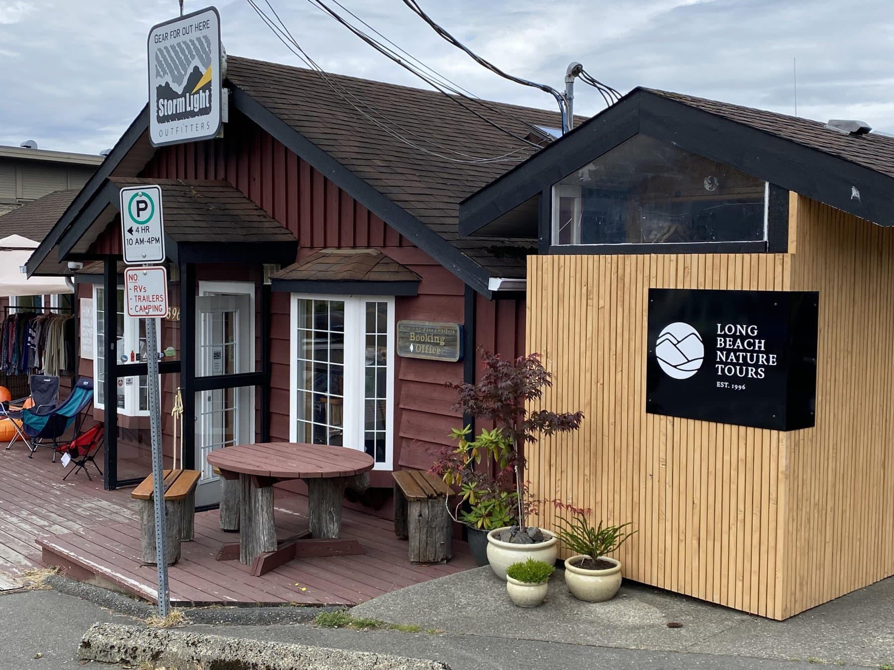
The LBNT Guide Hut is attached to Storm Light Outfitters located in Tofino. Address: 390 Main Street, Tofino BC V0R2Z0 Transportation to the meeting location is not included in the price of the trip but as this is a point to point hike, we do supply the shuttle back to Tofino at the end of the route. There is plenty of parking available at our office where you can leave your vehicle for the duration of the trip. For this trip, either flying into the Tofino Long Beach Airport (YAZ) or driving to Tofino via the Vancouver/Nanaimo ferry if you are coming from off island are the 2 best options. If you wish to stay close to the meeting location the night before the trip, there are many options to choose from ranging from luxury hotels, vacation rental homes, cabins, and motels. We recommend visiting the Tourism Tofino website to see the list of all accommodation providers with their current availabilities.
GEAR WE PROVIDE
We provide all group gear which includes the following: | MSR 3 person tents | Synthetic-fill sleeping bags (or bring your own) | 70L Backpack (available for rent) | Thermarest sleeping pads | Trekking Poles | Cooking stoves and cookware | Bear spray and food canisters | First Aid Kit | Emergency Communication Device
GUEST PACKING LIST
Upon booking this trip, you will gain access to a downloadable trip information document containing a packing list tailored to the specifics of this route. Essential items for all trips include sturdy hiking shoes or boots, rain gear, a recommended clothing system, a headlamp or flashlight, a hydration system (water bottles and/or bladder), and additional items specific to each trip. We can provide sleeping bags and backpacks if needed but commonly participants opt to bring their own.
Discover more Adventures
Hiking tours, cultural tours.
Backpacking Trips
Have a Question?
Our team at the Long Beach Nature Office looks forward to hearing from you!
Nature & Wildlife Tours
Hiking & Biking Tours
Fly Fishing Trips
History & Cultural Tours
Terms & Conditions
About Our Region
Activity Ratings
Join Our Team
+1.250.725.3320
[email protected]
Box 1132 Tofino, BC V0R2Z0
Storm Light Outfitters
390 Main Street, Tofino BC
Agent Login
Privacy Preference Center
Privacy preferences.
- Skip to main content
- Skip to "About government"
Language selection
- Français

West Coast Trail: Hike of a lifetime
Pacific rim national park reserve, balaats’adt (nitinaht village) trailhead.
Information on hiking in or out of the West Coast Trail's midway trailhead located in the Village of Nitinaht.
Be prepared for the challenges you might experience on the West Coast Trail.
Plan for your backcountry hiking trip on the West Coast Trail including, fees, group size, and orientation sessions.
Reservations
Learn more about how to make a reservation to hike the West Coast Trail in Pacific Rim National Park Reserve.
What to pack for your backcountry hiking trip on the West Coast Trail.
Transportation
Getting to and from Pachena Bay, Gordon River and Nitinaht Trailheads on the West Coast Trail.
Learn how to have a safe and enjoyable trip when hiking the West Coast Trail in Pacific Rim National Park Reserve.
Frequently asked questions
Read the answers to frequently asked questions about hiking the West Coast Trail in Pacific Rim National Park Reserve.
Related links
Links to other helpful resources for booking your trip on the West Coast Trail.
Maps and brochures
Please note:.
- Reservations are mandatory
- Campers can book their adventure by visiting reservation.pc.gc.ca or by calling 1-877-RESERVE (1-877-737-3783).
- Keeha Beach is OPEN for overnight visitors May 1 to September 30. Reservations are required.
The Nitinaht Triangle remains closed until further notice.
- Motorized and non-motorized vessels, including kayaks, paddleboards or canoes, are not permitted to land anywhere within the West Coast Trail Unit.
Visit the Pacific Rim National Park Reserve COVID-19 page for updates on park facilities and services.
History | Reservations | Resources
Is this hike right for you?
Before you decide to make a West Coast Trail reservation for yourself, learn what you are signing up for and make sure this hike is right for you.
Before you make a reservation:
1. Read the WCT Hiker Preparation Guide (PDF, 1 MB)
2. Watch the WCT Hiker Preparation Guide Video
West Coast Trail Hiker Preparation Guide
Animated title sequence: The West Coast Trail, Pacific Rim National Park Reserve, Parks Canada logo
[Hikers enjoying the trail]
[Narrator] The West Coast Trail is a multi-day backcountry hike along the west shoreline of Vancouver Island.
[Animated map of the West Coast Trail] [Animated text: West Coast Trail | 6 to 8 Days | 75 km]
Spanning 75 kilometres from Pachena Bay to Gordon River, " the trail lies in the traditional territories of the Huu-ay-aht, Ditidaht, and Pacheedaht First Nations.
[Montage of Huu-ay-aht, Ditidaht, and Pacheedaht First Nations people cutting down trees, clearing brush, and conversing with camera man on the West Coast Trail]
These Nations have been here since time immemorial and continue to call Vancouver Island home. Today, through cooperative management, the West Coast Trail Guardians from each of these Nations help maintain the trail, share stories and welcome hikers.
[Hikers encountering bridges, ladders and uneven terrain on West Coast Trail.]
This is one of British Columbia’s most challenging hiking routes. It covers extremely difficult terrain and should only be attempted by seasoned backcountry hikers with multi-day trek experience.
[Hikers with large backpacks walking along beach]
Before reserving your space, know what you’re signing up for to make sure this hike is for you.
[Animated title sequence: Is the West Coast Trail Right for You?]
[Montage of West Coast Trail hikers descending tall ladders, walking along beach with other hikers, and balancing on narrow sections of raised trail.]
Hiking the West Coast Trail is difficult, even for experienced hikers. " Most people will spend between 6 and 8 days in the backcountry, when travelling from end-to-end. There’s also a mid-way entry point at Nitinaht Village, which can shorten your journey by a few days.
[Hikers walking on slippery rocks, crossing a flowing river, propelling the cable car and traipsing through ankle-deep deep mud.]
Strenuous terrain, fast-flowing river crossings, ladders and cable cars, mud and rain are guaranteed challenges. On top of that, you’ll have a heavy backpack and will likely be exhausted.
Animated text: Did You Know? Help can take up to 24 hours to reach you. [Search and Rescue boat arriving to shore]
Did you know that if you get injured on the trail, it can take up to 24 hours for help to reach you? Before you decide to take on the trail, ask yourself these questions:
Animated text: Yes or No. Hiked overnight before? [Hiker setting up tent]
First, have you and everyone in your group done a multi-day, overnight backcountry hike before?
[Confident hiker explaining something to other hikers]
Remember, an experienced hiker can’t compensate for someone inexperienced.
Animated text: Yes or No. Able to hike long distances?
Number two: can you hike long distances over rough terrain with a heavy pack? You’ll be carrying all your supplies on your back.
[Hiker climbing down ladder with large, seemingly havy backpack]
Climbing up ladders and over slippery ground with that extra weight is difficult.
Animated text: Yes or No. Are plans flexible?
Third, are your plans flexible in case of delays?
[Hikers on West Coast Trail during heavy rain and walking quickly along a narrow section of trail]
Forging ahead in bad weather, hiking late in the day or rushing to finish often leads to injury.
[Montage of hikers standing on bank of crashing river, deciding not to cross and waiting out a storm]
Floodwaters, repairs or an accident on the trail can delay your trip by days. If you can’t be flexible, rethink your plan.
Animated text: Yes or No. Healthy and injury-free?
Next, are you healthy and injury-free?
Animated text: Recent surgery, Concussion, Heart condition, Recurring injuries
If you’ve had a recent surgery or concussion, suffer from a heart condition, or struggle with recurring knee, ankle or back injuries, this hike is not for you.
[Search and Rescue team flying over trail in helicopter and assisting injured hiker.]
Joint injuries are a leading cause of evacuation —even something as small as an aggravated knee should be cleared by your doctor.
Animated text: Yes or No. Everyone over the age of 12?
Finally, is everyone in your group over the age of 12? All hikers must be at least 6 years old to get an overnight permit, though the trail isn’t recommended for anyone under 12.
Animation: Adult and child hiker with red "X" flashing over child, indicating children under twelve should not attempt the West Coast Trail.
If you have children, it's best to choose another hike.
Animated text: Yes or No? Animated checklist with all five items checked off: - Hiked overnight before? - Able to hike long distances? - Are plans flexible? - Healthy and injury-free? - Everyone over the age of 12?
If you answered YES to all five questions, the West Coast Trail may be a great fit for you.
Animated text: reservation.pc.gc.ca
Reserve your spot early, as hiking allocations go quickly!
Animated checklist with four items checked off and one list item with a red ""X"" beside it: - Hiked overnight before? - Able to hike long distances? - Are plans flexible? - Healthy and injury-free? - Everyone over the age of 12?
If you answered NO to EVEN ONE of these questions, consider one of many beautiful alternative hikes.
Animated list of alternative hikes: Juan de Fuca Provincial Park and Marine Trail – Vancouver, BC; Strathcona Provincial Park – Vancouver, BC; Wild Pacific Trail - Ucluelet, BC; Wild Side Trail - Flores Island, Ahousaht, BC
Now, it’s time to prepare…
Animated title sequence: How Do I Prepare for the West Coast Trail?
[West Coast Trail hikers walking over challenging, uneven terrain]
The West Coast Trail isn’t a hike you can decide to do on a whim —it’s a challenging trek, requiring careful preparation.
Animated title: When to Visit Animated text: Jan, Feb, Mar, Apr, May, Jun, Jul, Aug, Sep, Oct, Nov, Dec [May to August highlighted in green]
The trail is reservable from May to September each year.
Animated title: Weather Animated text: 14 degrees celsius, 330 cm of rainfall
Summer temperatures average 14°C and the area sees about 330 cm rainfall annually.
Animation: rainclouds hovering over May and June
May and June are particularly wet. Before setting out, there are a few things you need to do: First, put together a training plan.
[Man outside on a training hike with his backpack and hiking boots on.] Animation: Freeweight icon, heartbeat icon Animated text: 3 months beforehand
Start a full-body strength and cardio program at least 3 months before your hike with uphill endurance training in mind. Practice hiking with your weighted pack and hiking boots well in advance.
[Hiker packing up campsite and typing up trip plan]
Remember, this should not be your first overnight backpacking experience! Before you leave, write out a trip plan and share it with your emergency contact.
Animated text: Where are you going? Who are you travelling with? What's your expected itinerary? What should they do if you don't return?
Include where you’re going, with whom, your nightly itinerary, an anticipated return date and instructions on what to do if you don’t return.
Because there are three access points to the trail,
[Search and Rescue helicopter landing on beach]
these details will be extremely helpful if search and rescue is required. Finally, while you’re on the trail, keep these safety tips in mind:
Animated text: Safety Tips. Take your time.
Move with caution, take breaks and set reasonable travel expectations.
[Montage of hikers rushing over tree roots and uneven surfaces on the West Coast Trail, then examples of hikers taking their time]
Accidents happen when people are tired or moving too fast. Always assume terrain is slippery and hike at the pace of your slowest group member.
Animated text: Safety Tips. Stay warm and dry.
Stay warm and dry.
[Hikers putting on sweaters and hiking during heavy downpour]
Injury and hypothermia happen more easily in cool, rainy weather, which is common on the trail, even in summer.
Animated text: Saftey Tips. Stay hydrated and well-fed
Keep hydrated and well-fed. It’s easy to become dehydrated and undernourished on the trail.
[Hikers stopping for snacks and mixing up trail food nad collecting water from streams, then filtering or boiling it]
You should be eating plenty of nutritious, high calorie food and drinking enough that you need to make regular pit stops —even on cooler days. Drinking water can be collected from most rivers and creeks —but to be safe, you should always carry enough to get you to the next large fresh water source. Always collect your water upstream and purify before drinking.
Animated text: Saftey Tips. Treat structures with respect
Treat the structures with respect.
[Hikers climbing ladder one at a time, loading gear in cable car before getting in and practicing general cable car safety
Limit the number of hikers at a time on ladders and cable cars and secure your equipment, straps, and clothing in the car before leaving the platform. Let the cable car come to a complete stop before pulling the rope to move yourself to the other side and keep your fingers and hair away from the pulleys!
Animated text: Saftey Tips. Be prepared for floodwaters
Be prepared to wait for floodwaters to subside at river crossings, which can take days.
[Hikers stopping to asses flowing river depth]
Don’t cross when water is flowing above the knees, as currents can easily sweep you downstream.
Animated text: Saftey Tips. Use tide tables
Use your tide tables and West Coast Trail map
[Hiker trapped by impassable headlands]
to avoid being trapped or cut off by impassable headlands.
Animated text: Saftey Tips. Store food properly [Hiker locking up food in metal wildlife-proof bin]
Always hang your food and garbage or store them in a wildlife-proof bin at the campsites so you don’t attract wild animals.
Animated text: Saftey Tips. Don't rely on cell phone
Lastly, there’s limited cell service on the trail.
[Hiker sitting on log, setting up safety device before heading out on hike]
If you have a safety device like a “SPOT”, “InReach” or satellite phone, learn to use it beforehand and have emergency messages pre-entered, just in case. Now that you’re familiar with the trail, it’s time to start packing.
[Animated title sequence: What Should I Pack for the West Coast Trail?]
[Hikers strapping on gators by stream and packing up campsite]
Your experience on the West Coast Trail will be far better if you’re comfortable and well-prepared.
[Hiker adjusting straps on backpack]
The first thing you’ll need is: A well-fitted backpack with a padded hip belt to distribute weight.
[Animated hiker icon offering supporting visual for 15-20 % bodyweight]
Your pack should weigh no more than 15-20% of your body weight.
[Hiker hanging backpack on outdoor scale at trail head and checking weight]
Weigh your bag as you pack and keep asking, “Do I really need this?”.
[Hiker adding unneeded items to bag with red "X" flashing overtop, indicating items are unnecessary]
Things like electronics, solar panels, and instruments are tempting but downtime on the trail
[Hikers boiling a pot of water on a camp stove and conversing around a campfire]
is usually spent cooking, socializing or sleeping. Sharing items like a tent, stove, pots and pans with your group can lighten the load and make everyone’s hike more comfortable!
[Hiker lining backpack with black garbage bag, then sealing clothes in a second garbage bag and placing in backpack]
Line your pack with a heavy-duty garbage bag or waterproof liner to protect your gear. You can also seal your sleeping bag and night clothes in an extra garbage or dry bag for added security.
[Hiker walking around campsite testing pack weight] [Hiker walking through parking lot with items swinging off side and red ""X' flashing over the improperly packed bag]
All your equipment should fit inside your pack, with heavier items near the bottom. Don’t leave anything swinging off the sides —it could get caught on trees or rocks and throw you off balance.
[Hikers lacing up boots and testing on slippery surfaces]
The next thing you need is proper hiking boots. Quality boots with good ankle and arch support are a must. Opt for soft rubber soles for traction on slippery surfaces and break your boots in at least one month before your hike
[Photo of tent, sleeping bag, and sleeping pad lined up with animated labels]
For shelter, a tent with a waterproof fly is necessary. You’ll also need a synthetic-filled sleeping bag and a sleeping pad for proper insulation at night.
[Closeup of hiker stirring pot of oats over a camp stove]
For meals, pack foods that are high energy, lightweight, and quick cooking,
[Photo of dehydrated meal, dried fruit and almonds, energy bars, and bag of oatmeal, with animated labels]
like dehydrated meals you can add water to, energy bars, dried fruit and nuts, and oatmeal.
[Person adjusting temperature on camp stove and writing out meal plan on pad of paper]
Bring a lightweight stove and fuel and plan your meals before your trip to keep pack weight to a minimum.
[Hiker going through backpack and pulling out sealed bag of trail food]
It’s a good idea to have at least a day’s worth of emergency rations in case you end up on the trail longer than expected.
[Photo of rain gear, under layers, rain gear, socks, hat and gloves]
For clothing, bring a waterproof jacket and pants, quick-dry under-layers that will stay warm when wet, like wool, fleece and Polypropylene, as well as proper hiking socks, a warm hat, and gloves.
[Hikers walking through a downpour]
Avoid cotton and jean materials—again, hypothermia is a risk if you get wet, Even in summer, the coast is typically blanketed with fog, meaning cool, damp conditions.
[Animated icons of a watch, a bandaid, rope, a water droplet, walking sticks, a lighter, and an emergency signaling device]
Other important items to remember are a watch to use with tide tables, a first aid kit including prescription medication, 15 metres of rope to hang your food, a water container and purification system, collapsible hiking poles, a waterproof fire starter and, if possible, an emergency signaling device…
[Hikers trying to find the right way to go]
Remember, your cellphone will be unreliable on the trail.
Animated text: parkscanada.ca/wct-brochures
There are a few other items to consider bringing. Download the West Coast Trail Hiker Preparation Guide from the Parks Canada website for the full list.
[Hikers taking ofdf backpacks and sitting down in red Parks Canada chairs to enjoy the view]
The West Coast Trail is an incredible bucket list experience —one you’ll remember forever. Now that you’re prepared, it’s time to get out there and start training. Happy trails!
[Parks Canada logo Like. Comment. Share. PC.GC.CA social media logos]
Are you prepared?
The West Coast Trail (WCT) is an iconic backcountry, multi-day backpacking trail that is a bucket list challenge for many hikers. It is an experience that can bring even the most experienced hikers to their knees. Those who are well prepared physically, mentally, and equipment-wise, come away with tales of grit.
Hikers climb more than 100 ladders with a heavy pack, trudge through deep mud, wade through mountain-fed rivers in fast-flowing hip-deep waters, and push through whatever weather the wild West Coast delivers — often driving wind and rain.
The 75-kilometre (47-mile) West Coast Trail is part of the ancient paths and paddling routes used for trade and travel by first nations. Huuay-aht, Ditidaht, and Pacheedaht villages and camps were well established before the foreign sailing ships started to arrive off this coast over 200 years ago. As the years passed and the number of ships sailing the Juan de Fuca Strait increased, so too did the number of shipwrecks and drownings along the coast. In time, the coastline became known as “the Graveyard of the Pacific.”
In 1906, when the steamship Valencia went down with the horrific loss of more than 125 lives, the public outcry prompted the Canadian government into further action: Pachena Lighthouse was constructed in 1907; lifesaving stations were established at Cloo-ose and Bamfield; the telegraph route was upgraded to become the Dominion Life Saving Trail, complete with six shelters stocked with provisions for both shipwreck victims and their rescuers. As navigation technology improved, many of these measures became obsolete and were abandoned.
In 1970, Pacific Rim National Park Reserve was established and in 1973, the lifesaving trail was included in the national park reserve as a recreational hiking trail, beginning a new chapter in its history. Today, over 7,500 backpackers hike the West Coast Trail every year. They come to see the beauty, experience the challenges, and walk the path of those that came before them.
The West Coast Trail is OPEN May 1 to September 30.
Reservations for the West Coast Trail can be made for the 2024 season as of:
- 8 a.m. PST on January 22, 2024. To reserve call 1-877-RESERVE or visit www.reservation.pc.gc.ca
West Coast Trail Reservations
Balaats’adt (nitinaht village) trailhead: 3-5 day adventures.
The West Coast Trail can be intimidating, even to the most seasoned adventure-seeker. A mid-point entrance at Nitinaht Narrows (only accessible by water taxi from Balaats’adt (Nitinaht Village)), allows hikers to tackle a shorter portion.
Cape Beale Headlands
Located near Bamfield, this rugged section of shoreline is home to the historic Cape Beale lighthouse. Cape Beale Headlands provide a chance for visitors to sample the same terrain as the 75 km West Coast Trail. These challenging hikes wind through temperate rainforest to spectacular west coast beaches. All day and overnight users of the Cape Beale Headlands are required to register at the West Coast Trail Information Office at Pachena Bay.
Keeha Beach is OPEN for overnight visitors May 1 to September 30.
Anyone camping at Keeha Beach must have a backcountry use permit. Backcountry use permits are only available through the Parks Canada Reservation System. No spaces will be available for stand-by (first come first serve).
Reservations for Keeha Beach can be made for the 2024 season as of:
- 8 a.m. PST on January 19, 2024. To reserve call 1-877-RESERVE or visit www.reservation.pc.gc.ca

- ʔapsčiik t̓ašii (Multi-use pathway)
- 150 adventures for your bucket list
- Cycling, mountain biking, and e-biking
- First Nations cultural experiences
- Kapyong Memorial at Radar Hill
- Kwisitis Visitor Centre
- School and group programs
- Storm watching
- Volunteer opportunities
- Licensed operators
The West Coast Trail: Complete 2024 Hiking Guide
The West Coast Trail is one of Canada’s most iconic hiking trails.
The demanding 75km journey traverses Vancouver Island’s rugged coastline, taking in windswept sandy beaches, gnarled old-growth forest, slippery boulder fields, surge channels and tidal pools.
Most thru-hikers spend 6 to 8 days on the West Coast Trail (WCT), camping at designated beach campgrounds along the way.

Hikers can also enter at a midpoint location and enjoy a shorter 3-5 day adventure on the trail.
This comprehensive guide will help you prepare to hike the West Coast Trail.
It features an overview of the trail plus all the planning information you need to know.
This includes the low down on how much the West Coast Trail costs, how reservations work, safety considerations and essential items to bring.

Since I had so much information to share, I also created some separate, dedicated guides to the most discussed topics:
- Complete West Coast Trail Campground Guide
- West Coast Trail Transportation Logistics
- WCT Hiking Itineraries: 5, 6, 7 + 8 Days
- WCT Packing List: The Best Items to Bring

The breakdown of this post looks like this:
- About the West Coast Trail
- Gordon River to Thrasher Cove
- Thrasher Cove to Camper Bay
- Camper Bay to Walbran Creek
- Walbran Creek to Camanah Creek
- Carmanah Creek to the Crab Shack
- The Crab Shack to Klanawa River
- Klanawa River to Tsocowis Creek
- Tsocowis Creek to Pachena Bay
- Trail length
- When to hike
- Orientation
- Reservation system
- Campgrounds
- Trail accommodation
River and creek crossings
- Hiking direction
- Itinerary suggestions
- Safety information
- Essential items to bring
- Trail restaurants
- Where to stay pre and post hike
Planning resources
Last updated January 2024

West Coast Trail (WCT) Location: Gordon River to Pachena Bay, Vancouver Island Distance: 74km Elevation change: Minimal Hike type: One-way Time : 5-8 days Difficulty: Challenging Dogs: Not permitted

Backpacking necessities
Before attempting the West Coast Trail:
- Remember to bring the 10 Essentials
- Know how to stay safe and also avoid negative bear encounters
- Understand how to Leave No Trace to help keep the WCT beautiful
- Be prepared to pack out everything you bring with you
- Check out our recommended gear for backpacking
- Need a backpacking checklist? Sign up to our newsletter for a free one
About the West Coast Trail (WCT)
The West Coast Trail is located in Pacific Rim National Park Reserve , on Vancouver Island, British Columbia, Canada.
Despite being one of Canada’s most famous hikes, not everyone may know the interesting story of how the West Coast Trail came to be.

Land of the Huu-ay-aht, Ditidaht, and Pacheedaht
The West Coast Trail is located on the traditional territory of the Huu-ay-aht, Ditidaht, and Pacheedaht First Nations.
Rich in food sources (salmon, mussels, sea urchins, crabs, deer, elk, berries), villages and camps have been established on this coastline for thousands of years. The West Coast Trail follows ancient First Nation paths used for travel and trade.
Members of the Huu-ay-aht, Ditidaht, and Pacheedaht First Nations work with Parks Canada as West Coast Trail Guardians , to protect and care for the trail as well as visiting hikers. There are Guardian cabins at two WCT locations.
Learn more about each nation’s culture and history:
- Huu-ay-aht (“hoo-ay-at”)
- Ditidaht (“dee-tee-daht”)
- Pacheedaht (“pah-chee-dat”)

The Dominion Life Saving Trail
European ships began to arrive on the west coast of Vancouver Island in the late 18th century.
As the number of boats increased throughout the 19th century, as did the number of shipwrecks and drownings.
In 1889, the Dominion of Canada built a telegraph system along the coast from Victoria to Cape Beale (southwest of Bamfield).
But the danger remained and this coastline became known as ‘the Graveyard of the Pacific.’
The government was soon forced to take further action. In 1906, The SS Valencia ran aground near Tsocowis Creek with more than 125 lives lost from a total of 160 passengers.
Soon afterwards, the Pachena Lighthouse was built and the telegraph route was upgraded to become the Dominion Life Saving Trail.
The path featured six shelters stocked with essential supplies for shipwreck victims and their rescuers.

Transformation to the West Coast Trail
Navigational equipment continued to improve over the next few decades. The Dominion Life Saving Trail eventually fell out of use.
Fast forward to 1970 and the establishment of the Pacific Rim National Park Reserve. The Dominion Life Saving Trail was converted to a recreational hiking trail a few years later.
In 2024, more than 11,000 hikers will set out on the West Coast Trail.
The official Parks Canada West Coast Trail map , given to all hikers at orientation, pays respect to the trail’s history with original First Nation place names as well as shipwreck locations.

Hiking the WCT: Our experience
Before getting into the trail guide, I’m going to share an overview of our own 8 day hike on the West Coast Trail in 2021.
If you like, you can skip to the trail guide by clicking here .
For each day of hiking, I have provided our total time as well as moving time.
We took a pretty relaxed approach to the West Coast Trail, stopping often for rest breaks, beach combing, wildlife watching, swimming and lengthy chats with other hikers. Some days, we ate breakfast on the trail.
Most of our hiking days therefore appear to be quite long. The moving time provides a better guide as to what to expect, especially if you usually hike around 3-4km/h like we do.

Day 1 – Gordon River to Thrasher Cove
Distance : 6km Total Time : 4.5 hours Moving time: 3.5 hours
Our day started with a escort from the Parks Canada Office to the ferry dock. A short boat ride across the Gordon River later, we were staring up a very tall, almost vertical ladder at the WCT’s southern trailhead.
Yep, the first West Coast Trail ladder is one of the longest and steepest! It’s a psychological challenge, but a good one to get over and done with so early.
Parks Canada staff advise that hikers should expect to cover 1km/h for the first 6km of the trail, stating that it is the hardest section.

While I didn’t think it was easy, I wasn’t overly surprised by the type of terrain. A bit of mud, some rocks, lots of tree roots, the odd downed tree – classic Vancouver Island hiking plus half a dozen or so ladders.
This section was a good quad workout, with lots of stepping up, down and over things. Now that I’m able to compare this WCT section to others, I’d say that later stretches are more difficult.
The biggest challenges were a short sloped rock traverse, a detour around a collapsed bridge and the slow ascent up to the West Coast Trail’s highest point – 230m.

Highlights included the derelict donkey engine just past Kilometre 72 (the perfect place for a break) and some beautiful old-growth trees.
Descending down to Thrasher Cove was steep, made more difficult by the loose rock surface. A series of tall ladders announced our imminent arrival at the beach.
Despite it only being 3pm, Thrasher Cove was already busy with hikers. For the next week, we would crisscross many of these hikers along the trail.

Day 2 – Thrasher Cove to Camper Bay
Distance : 6.8km Distance from Gordon River: 12.8km Total Time : 7 hours Moving time: 6 hours
Waking up with sore quads, I was a little apprehensive for the day ahead.
Though I really wanted to hike the coastal trail to Owen Point, the idea of traversing an almost 2km long stretch of boulders was pretty intimidating.
At least it would be over and done with at the start of the day! We had perfectly timed our second day for low tides around midday.

Averaging less than 1km/hr, I found this section as challenging as I’d feared, especially in the light rain.
Slippery rocks to start, followed by huge boulders and piles of giant driftwood, covered in seaweed and barnacles.
I was glad I wore gardening gloves as I spent a lot of time crawling and climbing. Being more agile, JR scouted the route ahead and hopped between rocks.
Owen Point was an excellent reward, with colourful, airy caves to explore. Slick rock shelves followed and then surge channels. Some hikers hopped right over the narrowest of these deep inlets, but I preferred to find the inland detour.

Leaving the beach at Access Point B, the transition back into the lush rainforest was sudden.
The forest obstacle course featured broken boardwalks, fallen trees, huge root systems and mud. Some beautiful old growth trees provided a good distraction.
One tricky hurdle was a partially destroyed elevated boardwalk, difficult to use but also impossible to avoid.
Camper Bay was waiting on the other side of yet another collection of ladders and our first cable car crossing.
Though I wasn’t a fan of the view-less campground, the camaraderie after such a challenging day was welcome.

Day 3 – Camper Bay to Walbran Creek
Distance : 9.2km Distance from Gordon River: 22km Total time : 9 hours Moving time : 6.5 hours
The easiest way to sum up our damp third day on the West Coast Trail? Ladders, boardwalk and bog.
From Camper Bay to Walbran Creek, the trail retreats into the forest, offering only the smallest glimpses of the coast.

The one exception is at Cullite Cove, which offers an ideal lunch stop destination. It’s also an excellent way to break up an exhausting stretch of 19 ladders (!!)
Despite being inevitably muddy, hiking through the shoreline bog was one of my favourite moments of the day.
I just loved the stark contrast between the thick old growth forest and the open landscape of the bog, with stunted bonsai-like trees lining the path alongside sticky carnivorous plants.

This section of the West Coast Trail has been made easier in recent years, with the construction of a brand new suspension bridge at Logan Creek.
The old bridge led to a very sketchy-looking set of ladders, which no longer exist.
Each side of the bridge features a comfortable seating area. We bumped into two sets of familiar hikers here and enjoyed a second lunch.
We finished our long hiking day with some of our new friends. JR then went for a refreshing swim in cold Walbran Creek, while I put up the tent in the forest.

Day 4 – Walbran Creek to Carmanah Creek
Distance : 6.9km Distance from Gordon River: 28.9km Total time : 3.5 hours Moving time : 2.25 hours
Another day of coastal fog awaited us as we packed up the tent at Walbran Creek, a little later than normal.
But we knew it would still be a great day – we had finished the most challenging sections of the West Coast Trail and were now able to veer away from the ‘standard’ itinerary followed by most northbound hikers.

Even better, we had planned a super short hiking day. Our destination was Carmanah Beach, said to be one of the best places to camp on the West Coast Trail.
Just 7km of beach walking lay in our path, starting with a long stretch of soft sand and then pea gravel.
Both act a bit like quicksand, sucking your feet down with every step. If you’re not wearing gaiters, you’ll likely be picking out rocks every few metres.
As we approached Bonilla Point, things started to get interesting. Think tidepools, cliffs, rock pillars topped with trees, massive mussel patches, scuttling crabs and even a waterfall.

JR also found numerous fossils, including shells and wood. Debris from Japan and China were scattered along the beach too. This section of beach really was a treasure trove!
Carmanah Beach was the oasis I had been waiting for – a long, sandy stretch of sand with incredible views of the ocean and lighthouse. With the tide out, we were able to cross the creek without using the cable car.
We had the expansive campground all to ourselves until 8pm, when hikers arrived from Tsusiat Falls. They said it had taken them almost 12 hours.

Day 5 – Carmanah Creek to the Crab Shack
Distance : 13.8km Distance from Gordon River: 42.7km Total time: 5 hours Moving time : 4 hours
As the only hikers from our campground heading north, we started our day in complete solitude. Just pass Carmanah Lighthouse, however, we were surprised by the sight of a very tall, very upright fin in the ocean. An orca!
It had been close to a rock covered with sea lions. With the tide coming in, we decided to sit and wait to see if anything would happen. Unfortunately, the fog soon eclipsed our view.

After passing Cribs Creek, we didn’t see a soul for hours. The feeling of remoteness heightened.
It increased still when we found a seal carcass at the edge of the forest, dragged there from the beach.
The pools of blood indicated that it had been moved pretty recently. Needless to say, we left the area quickly.
After crossing huge rock shelves and boulders, we climbed up to a high coastal trail and then almost immediately back down to another beach…and then again. The beach access points were tricky to spot.
Waiting on the other side of the last headland was the most spectacular beach on the entire WCT. It’s not possible to camp on Cheewhat Beach, so we just enjoyed hiking on the hard packed sand instead.

Though the final stretch was mostly boardwalk, some care was required. Arriving at the Crab Shack, we were happy to see some familiar faces again.
We were even happier to get our hands on some long awaited seafood – fresh crab, halibut and salmon, accompanied by a couple of fully loaded baked potatoes and cold cans of soda.
Having booked to stay at the Crab Shack’s covered tent deck for the night, we were done for the day.
The sun had finally come out, so we played some games, drank some cold beers and enjoyed more seafood for dinner.

Day 6 – The Crab Shack to Klanawa Creek
Distance : 9.5km Distance from Gordon River: 52.2km Total time : 6.5 hours Moving time: 3.5 hours
For a backpacking trip, our day six morning was pretty surreal. Hot tea by a woodstove and fresh crab for breakfast. We ordered wraps to go before hopping on the Nitinaht Narrows ferry.
Back on the trail and reunited with the coastal fog, we spotted more old growth trees and enjoyed some gorgeous elevated views of the beach.
Here, the trail follows the edge of a very high, steep cliff. At one point, I tripped towards the drop-off. Luckily, JR was very quick to grab me.

Our tides were perfect to hike on the beach for most of the distance to Tsusiat Falls, including through the beautiful ‘Hole in the Rock.’ The fog had lifted and we were now getting hot.
Tall cliffs led us to Tsusiat Falls, where we quickly got ready to swim. Swimming under the cool, cascading water was glorious.

After almost three hours of swimming and sunbathing at Tsusiat Falls, we decided to head to a quieter campground for the night.
The hike to Klanawa River Camp took just over an hour and featured ladders, boardwalk and a cable car crossing. Though the campground was not empty, we did enjoy a beautiful sunset (our first!)

Day 7 – Klanawa Creek to Tscowis Creek
Distance : 6km Distance from Gordon River: 58.2km Total time: 3 hours Total moving time : 2 hours
Waking up in time for sunrise, the day started clear and bright. This would be our shortest hiking day and it also happened to have the best weather.
The low tides were perfect for our departure from Klanawa, offering us the chance to peek into tidepools along the way. Hundreds of crabs scuttled away as we hiked across seaweed scattered rock shelves.

Ladders led us up back to a high trail above the coast. And what a trail this was! Wide and almost completely flat, we couldn’t believe our luck. Even the boardwalk sections were in good shape.
We stopped to check out the derelict donkey engine and grader and then again at the Valencia Bluffs lookout.
The SS Valencia ran aground on the rocks beneath the cliffs here in 1903, with huge loss of life. With the coastal fog clinging on, our view was limited.

Another collection of ladders and we were back on the beach…and also at our camping destination!
Arriving at 1pm, we were able to enjoy Tsocowis Creek Camp to the fullest.
The sun came out less than an hour later so we spent the day exploring the beach, sunbathing, reading, playing games and checking out the nearby waterfall. A handful of southbound hikers joined us later in the day.

Day 8 – Tscowis Creek to Pachena Bay
Distance : 16.8km Total time: 5 hours Total moving time: 4 hours
Though we could have finished the West Coast Trail on day seven, the weather was too good not to spend an extra night. And besides, I was starting to feel quite a connection to the trail.
We got up just after sunrise, keen to start our long hike out. The first part of the day was spent entirely on the beach, mostly on sand. A few rocky sections slowed us down, as did the lure of some tidepools.

It was sad to leave the beach at Michigan Creek. The final 12km stretch was entirely in the forest.
Wonderfully wide and flat, this section was easy to hike although a little tedious. Highlights include some more old growth trees and an abandoned motorcycle.
We broke up the journey with a side trip to ‘Sea Lion Rock’, where a few dozen sea lions sit atop a rock outcropping, barking and fighting as the tides go in and out.
You can hear them before even reaching the turnoff! I thought it was definitely worth the short detour (700m return). If we could, we would have also visited the Pachena Lighthouse (closed to visitors in 2021 and 2022).

The final 500m of the West Coast Trail offered a choice between a forest or beach route. In my mind, the beach was the most dramatic way to finish. It also avoided some additional ladders!
A short traverse around a rocky headland was the last beach challenge, before the gorgeous sands of Pachena Bay appeared. We arrived just before 1pm, ideal timing if we had needed to get the bus.
As it was, our van was waiting for us in the parking lot. We had already taken the bus down to Gordon River before starting the trail. A quick clean up and we were on our way to a hotel in Campbell River!

Thoughts on the West Coast Trail
As someone who prefers to enjoy nature in solitude, I didn’t expect to love the West Coast Trail. Happily, I was proved wrong.
I did find it a trail of two very different halves, however. For the first three days, I didn’t quite get why people raved about the WCT.
While I was enjoying some aspects of the trail (old growth trees, ocean scenery), I was finding it to be a bit of a slog overall.
Being trapped in coastal fog wasn’t helping either, nor the impossibly busy nature of the campgrounds.

On day four, things began to change. Finally off the ‘standard’ West Coast Trail route, we found ourselves alone on the trail for longer stretches. The campgrounds were also quieter.
This is when it all started to make sense. This was reinforced when the sun came out on day five.
Finally, I could see why people loved this trail – the challenge, the isolation, the immersion, the ever changing coastline.

By day eight, I didn’t want to leave. I would class that as a major turnaround.
Would I hike the West Coast Trail again? Actually, I think I would.
If the WCT wasn’t such an expensive hike (we spent around $1k for the two of us), I’d probably put it on my list for 2024 or 2025. But I’d consider just hiking the northern section.
A few months after hiking the West Coast Trail, we ventured out on the Nootka Trail. Check out our Nootka Trail guide to see how I compared the two trails!

West Coast Trail Hiking Guide
In this section, you’ll discover everything you need to know about hiking the West Coast Trail.
The text ahead includes some affiliate links. If you make a purchase via one of these links, I may receive a percentage of the sale at no extra cost to you.
Where is the WCT?
The West Coast Trail is located on Vancouver Island, the largest island on the west coast of North America.
Part of the province of British Columbia, Vancouver Island is about half the size of Ireland.
To get to Vancouver Island, you can either fly (by regular plane or seaplane) or take a ferry from the BC mainland/Washington State.
The West Coast Trail is found on the most southern third of the island, between the remote communities of Bamfield and Port Renfrew. Part of the trail overlooks Washington State in the USA.

How long is the West Coast Trail?
Officially, the West Coast Trail is 75km long. That is the distance given by Parks Canada.
In practice, however, the West Coast Trail is probably a bit longer than that.
Estimates vary, but most people who have tried to measure it say that the trail is probably around 10km longer.
There are kilometre markers along most of the route, but they do come and go. These markers count upwards from the Pachena Bay (northern) trailhead. Kilometre 75 is therefore at Gordon River (southern trailhead).

For the purpose of this post (and to keep things simple), I will refer to official Parks Canada distances as noted on the official West Coast Trail map. The map counts kilometres from Pachena Bay.
Where possible, I’ve tried to list both kilometre distances – the first from Pachena Bay (northern trailhead) and then the second from Gordon River (southern trailhead). If I’ve listed only one kilometre distance, then it is from Pachena Bay.
It is not necessary to traverse the entire 75km route to hike the West Coast Trail. Hikers also have the option to start at the mid-trail point, at Nitinaht Narrows.

How difficult is the WCT?
I would class the WCT as a challenging hiking trail. While not the hardest backpacking trail in British Columbia, the West Coast Trail is definitely not one to take lightly.
80 to 100 people are evacuated from the West Coast Trail each season. That means that there is a rescue at least every two days. And in my experience, this statistic is absolutely true.
Some of the rescues are related to fitness but most are the result of accidents – specifically slips, trips and falls on the slippery terrain.
In 2022, a hiker suffered eye and brain damage after falling on a branch in the forest. This hiker was both fit and experienced. Accidental injury on the WCT can happen to anyone.
It should also be noted that it took 5.5 hours for this hiker to be evacuated from the trail. Rescue is not necessarily quick or easy on the West Coast Trail.

Varying terrain
The route is long (75km), features a variety of terrain and is also located in an isolated area subject to challenging weather conditions such as torrential rain, high winds and fog. Some sections of the trail are always muddy.
The West Coast Trail has both beach and forest sections. In the northern half, the forest is traversed with a mostly level hiking path, with only little elevation gain or loss (besides the ladders).
In the south, the forest sections are more like an obstacle course. Expect rocky and uneven surfaces, fallen trees, huge tree roots, thick bog, rocky surfaces and slippery boardwalks of varying condition.
The beach sections vary hugely in difficulty too. The northern half features some lovely long stretches of sand (compact when wet) while the south also offers boulder fields, surge channels and quicksand-like beaches.

The difficulty of the WCT significantly increases according to the season and condition of the trail, as well as weather experienced.
Rain is common in May, June and September, resulting in more mud, potential flooding and even slipperier boardwalks.
Coastal fog can be present at any time, but is more common in July and August.
‘But our weather forecast looks great!’ – yes, ours did too. Yet we were trapped in coastal fog for four straight days.
The average daytime temperature during our July trip was 12°C. Just 200m beyond the shoreline, the rest of Vancouver Island was enjoying blue skies and 23 ° C temps.
Length of trip
The length of your intended trip can also exacerbate the difficulty of the WCT.
An eight day thru-hike of the WCT will be inherently easier than a five day one.
Most people thru-hike the West Coast Trail in seven days, which allows for more time hiking the most challenging sections of the route.

Coastal hiking has some unique challenges, with ocean tides (the rise and fall of sea levels) being the most significant.
When hiking the West Coast Trail, you need to understand how to read a tide table and be prepared to hike according to it.
Skip to the tides section of this guide to learn more.

There are four significant river and creek crossings on the West Coast Trail. All have cable cars to help assist hikers with the crossings, but they may not always be operational.
After torrential rain, these rivers and creeks (and potentially other creeks as well) may flood.
Skip to the river crossings section of this guide to learn more.
Section by section breakdown
As mentioned above, some sections of the trail are easier than others.
Here are my ratings. Please note that distances are from Pachena Bay and the difficulty rating is given in relation to other sections of the WCT only.
Hiking the WCT as a novice backpacker
Parks Canada states that the WCT is for hikers who are:
- experienced in overnight backpacking AND
- able to hike long distances through rough terrain carrying a heavy backpack AND
- prepared to have a wilderness experience.
- able to wait if conditions warrant delays
I absolutely agree with this assessment.
For these reasons, I would not recommend thru-hiking the WCT as a first time backpacking trip. If you’re new to backpacking, I’d suggest a couple of overnight (or longer, if you can) hiking trips first.
Not only will this experience help dial down your gear and food preferences, but it will also get you used to carrying heavy loads over a sustained distance.
Fundamentally, you’ll also discover whether you actually like backpacking or not!
After starting the WCT, it is both difficult and expensive to leave without finishing.

When to hike the WCT
West Coast Trail’s operating season runs from the start of May to the start of October (1st May to 6th October in 2024).
The trail is closed the rest of the year ‘due to prolonged periods of heavy rain, strong winds, high tides, large waves, and short daylight hours’ ( source: Parks Canada ).
With a temperate rainforest climate, the West Coast Trail receives mild, year round weather with periods of heavy of rainfall from September to June. The average summer temperature is 14° Celsius (57° Fahrenheit).
In my opinion, July and August are the best months to hike the West Coast Trail. These months have the least amount of rainfall. Due to this, the trail will also be the driest.

On the negative side, fog is more common in July and August. This can really bring average daytime temperatures down. Campfires are often banned during these months as well.
Hiking the West Coast Trail in May, June and September is inherently more challenging. Periods of heavy rain are more common and the trail is likely to be wet and muddy. Flooding is also possible.
If you’re planning to hike the West Coast Trail in these shoulder season months, I would recommend having more flexibility with your schedule OR a slower itinerary (7 days minimum).
Wet conditions can slow hiking speed. In the case of flooding, it may not be possible to cross rivers or creeks immediately.

The best direction to hike the West Coast Trail
The West Coast Trail can be hiked northbound or southbound from each of the three trailheads.
The choice of which direction to hike is yours to make, however it is necessary to finalise this decision at the time of making a reservation.
West Coast Trail hikers starting at Gordon River are northbound, while Pachena Bay hikers are southbound.
Those starting at Nitinaht Narrows can choose whether to hike north or south. For an extra fee, Nitinaht Narrows hikers can actually hike both directions. I talk about this more in our dedicated West Coast Trail itinerary post.
So which direction should you hike? There is no perfect answer, but I can give you some pointers.

More difficult/easier terrain to start
As explained earlier in this guide , the southern end of the WCT (between Gordon River and Walbran Creek) feels more like an obstacle course than a hiking trail.
Personally, I like getting harder terrain over and done with. After we had passed Walbran Creek, the rest of the WCT felt like a breeze in comparison.
Some hikers like the idea of building up to more difficult terrain. For me, that would only cause anxiety.
I was much happier hiking the rest of the trail knowing that nothing would be more difficult than the section I had already passed, rather than worrying about what was ahead.
Heavier/lighter backpacks
Hikers starting at Gordon River must carry the full weight of their backpacks over the most challenging West Coast Trail terrain.
Southbound hikers, on the other hand, usually have lighter backpacks by the time they reach the Walbran Creek area.
I carried the majority of our food, so the weight of my backpack was reduced as we ate through our supplies. My backpack weighed 8lb (3.1kg) less at Pachena Bay than it did when I started in Gordon River.

Ferry timing
The Gordon River ferry runs from 8.45am to 3.30pm only. This isn’t a problem for northbound hikers, who take the ferry to start the trail.
Those heading southbound, however, need to plan ahead to ensure correct timing. With the southern end of the trail being so challenging, it is vital not to underestimate how long it will take to hike this section.
Hikers who miss the ferry are forced to camp on the tiny Gordon River beach for the night or backtrack to Thrasher Cove. The Gordon River beach has no outhouse, food storage or water source.
Transportation
Usually traversed in one direction only, WCT hikers start at one trailhead and then finish at another. For this reason, it is absolutely necessary to think about transportation logistics (so much so that I wrote a guide about it !)
All three trailheads are reasonably remote, and depending on where you are travelling from, you may need to travel for more than one day to reach them.
The West Coast Trail Express bus offers a shuttle service between the trailheads, but only arrives to each trailhead once during suitable hiking hours (12.30pm at Pachena Bay, 9.15am at Gordon River).
This may be a deciding factor of your decision-making process regarding which way to hike the West Coast Trail.

Trailhead accessibility
For some hikers, trailhead accessibility is the deciding factor for hiking direction.
With all thru-hikes (not just the WCT), my preference is to park a vehicle at the finishing trailhead.
This offers complete flexibility regarding finishing time. It also means that we can continue onto our next destination without hassle.
If this is also your preference, the type of vehicle you have may determine which trailhead you should start at.
Only accessible via unpaved industrial roads, Pachena Bay is a bumpy, long journey from anywhere on Vancouver Island. A high clearance vehicle is definitely advantageous.
Gordon River, on the other hand, is located on a paved road, and is only two hours drive from the city of Victoria.

Where does the West Coast Trail start and end?
The West Coast Trail has three trailheads. Entry or exit at any other point is not allowed, unless during emergency evacuation.
- Pachena Bay (northern trailhead), near Bamfield
- Nitinaht Narrows (mid-point trailhead), near Nitinaht Village
- Gordon River (southern trailhead), near Port Renfrew
All three trailheads are reasonably remote, with limited services and no cellular signal.
Located on a paved road, Gordon River is the easiest trailhead to access. It also has the most nearby services.
Nitinaht Village (the access point of Nitinaht Narrows) and Pachena Bay are accessible via unpaved industrial roads only. I highly recommend this Backroad Mapbook for navigating Vancouver Island’s complex logging road network.
Check out our dedicated West Coast Trail transportation guide for all the info you need regarding pre and post hike logistics. It really can be quite confusing to get your head around it!

Where to park
Vehicle parking is available at each of the West Coast Trail’s three trailheads. Again, the details can be found in our dedicated West Coast Trail transportation guide .
West Coast Trail orientation
All West Coast Trail hikers must attend an orientation at one of the trailheads. This can be completed either the morning before starting the hike or the prior afternoon.
At the orientation, hikers receive important safety information, a trail map and their West Coast Trail Overnight Use Permit.
Since 2021, the orientation has two parts. WCT hikers are sent a link to a video one week in advance of their starting date. All hikers in the group need to watch the video.

Hikers then need to check in at the West Coast Trail Office at their starting trailhead the morning before starting the hike or the prior afternoon and attend one of the set orientation sessions.
Orientation sessions take place at 10am and 2pm at the Pachena Bay and Gordon River WCT Offices, and 7am at the Nitinaht Visitor Centre.
The in-person part of the orientation is about 20-45 minutes long (depends on group size) and includes a run down of current trail conditions. There is also a brief, informal test on the video content (tide tables, ferry times, how to correctly store food etc.)
Hikers can attend either orientation session on their departure date OR the afternoon orientation the day before.

How to reserve the West Coast Trail
Only 75 hikers can start the West Coast Trail every day – 25 from Gordon River, 25 from Pachena Bay and 20 from Nitinaht Narrows.
Hikers must have a WCT Overnight Use Permit to backpack the trail. 100% of WCT Overnight Use Permits are reservable.
The West Coast Trail reservation system usually opens in January each year, with the date usually being announced in December of the preceding year.
Look for updates on Parks Canada’s ‘Plan Your Visit’ page. The actual West Coast Trail page is not updated as often.
In 2024, the WCT reservation launch date is 22nd January 2024 at 8am PT .
To reserve your spot, you’ll need to know:
- The date you’d like to start – between May 1 and September 30
- The entry point/trailhead you’d like to start at – Gordon River (south), Pachena Bay (north) or Nitinaht Narrows (mid-point)
- Your exit point – Gordon Bay, Pachena Bay or Nitinaht
- How many nights you’d like to spend on the trail – this can be revised at orientation and it is for safety purposes only
- Number and names of people in your hiking group – total number including yourself (names can be changed later)
- Contact phone number – the most convenient number for Parks Canada to contact you
- Emergency name and phone number – in case of an emergency situation on the trail
Reservations can be made online or by phone (1-877-737-3783). I will be focusing on the online process here.

Reserving the West Coast Trail online
The WCT is very popular and all spots will usually be booked within an hour or so of the reservation launch. Dates in July and August usually disappear first.
If you have a specific date, week or trailhead in mind, I’d highly recommend being ready for the reservation launch to secure your spot.
If not, you will likely have to rely on cancellations closer to your desired trip date.
Before the reservation launch, I would highly recommend getting very familiar with Parks Canada’s reservation platform. Practice making a reservation, so you know exactly what to do on the day. Speed matters.
Using the Parks Canada Reservation Service
- On reservation launch day, navigate to the Parks Canada Reservation Service homepage prior to the opening time (at least 10-15 minutes)
- You’ll see a holding screen , which explains that you’ve been put into an online waiting room. This helps to prevent server overload
- At launch time (8am PT), the page will automatically refresh
- Everyone waiting in the online waiting room will be randomly assigned a place in line to access the website. Your number will be displayed, along with an estimated wait time
- Once on the website, click the ‘ Backcountry ‘ tab and then ‘ West Coast Trail ‘
- Choose your preferred arrival and departure dates and party size , then click ‘Search’
- A map will appear below. Click the ‘ West Coast Trail ‘ (bottom right)
- Scroll up a little and select your Access Point and Exit Point from the drop down menus then the ‘Reserve’ button
- If everything was completed correctly and there is still availability, the next page will display your reservation details, along with Parks Canada rules. Tick the two boxes and select ‘Confirm reservation details’
- At this point, your reservation is temporarily secured. You now have 20 minutes to log in and pay
If there is no availability, click ‘ Calendar ‘ (to the left of the map). The green ticks signify available arrival dates from each access point. Click a date and then increase the number of nights on the right before clicking ‘ Reserve .’

West Coast Trail reservation tips
- Open a Parks Canada account. If you don’t already have an account with Parks Canada, be sure to open one ahead of time. It will save a LOT of stress
- It’s important to be flexible – have a few different dates in mind and be ready to adapt your plans
- Multiple devices can be used to make a reservation – each device is given a unique place in the virtual queue
- Make sure you select your exit point. If not, the payment will not go through properly
- Nitinaht Narrows is the least popular starting trailhead . If your original thru-hike plan doesn’t work out, consider whether you’d be content with a shorter backpacking experience
- If you don’t secure a reservation on launch day, don’t panic. Plans change and many people cancel before and during the hiking season
- Not sure who will be hiking with you? Don’t worry too much about names of the other guests on the reservation – they can be changed later
- Not sure how many days you will be on the WCT? No problem – Parks Canada will ask for a confirmation at the in person orientation
- Didn’t get a reservation? Check for cancellations often. You can also join this West Coast Trail Facebook group and look out for members looking to transfer their reservation
- It is not possible to ‘officially’ buy a reservation from someone else but the permit holder’s name can be changed by contacting Parks Canada. You can then organise payment directly with the other person

How much does the West Coast Trail cost to hike?
In quick summary, the West Coast Trail is not a cheap hiking experience.
Budget around $300-340 for the fees (breakdown below) plus $100-200 for local transportation costs (gas, bus, parking).
The below table lists mandatory WCT fees. A few things to note:
- The first four fees are paid at the time of reservation
- The National Park admission fee must be paid at orientation, before starting the hike.
- The Nitinaht Village ferry, for hikers starting at the West Coast Trail’s midpoint) must be paid in Nitinaht Village, prior to boarding the water taxi. Cash is preferred
The West Coast Trail is part of Pacific Rim National Park. Like other national parks in Canada, there is a daily admission fee. In 2024, the daily fee is $11.00/adult.
Most hikers traversing the length of the WCT will find it better value to purchase an annual pass.
The Pacific Rim annual pass costs $54.50/adult. Alternatively, you can purchase an annual Family/Group pass for $109.00. This covers admission fees for the permit holder and up to six other people into Pacific Rim for one year.
If you plan to explore beyond Pacific Rim National Park, Parks Canada’s Discovery Pass offers even better value.
A Discovery Pass offers unlimited free entry to more than 80 national parks and national historic sites across Canada for one year. It costs $75.25/adult or $151.25/group.
Discovery Passes and Pacific Rim Passes can usually be purchased at the trailheads. If you can get one beforehand, I’d recommend it as they occasionally run out.
Example fees – 7 day, 6 night Pachena Bay to Gordon River hike (or vice versa)
For WCT hikers traversing the full length of the trail over six days, the following mandatory fees apply:
Example fees – 5 day, 4 night Nitinaht Narrows to Gordon River hike
For WCT hikers traversing from the mid-point to the southern trailhead, the following mandatory fees apply:
Example fees – 4 day, 3 night Nitinaht Narrows to Pachena Bay hike
For WCT hikers traversing from the mid-point to the northern trailhead, the following mandatory fees apply:
Other fees to consider
The cost of hiking the West Coast Trail does not end with the mandatory fees charged by Parks Canada.
The vast majority of WCT hikers will find themselves finishing the trail at a different place than they started. It is therefore important to factor in transportation costs as well as the mandatory fees.
Bus is the most popular way to travel between the WCT’s trailheads. Here are the fees for the West Coast Trail Express (2024 prices TBC):
Additional services to Port Renfrew, Victoria, Nanaimo and Sooke are also available.
Vehicle parking
Vehicle parking is free at the Pachena Bay and Nitinaht Village trailheads. At Gordon River, a $7/night fee is charged per vehicle.
Accommodation
Something else to keep in mind is pre and post-WCT hike accommodation. We stayed at the Pacheedaht campground in Gordon River before starting the West Coast Trail.
The cost of food is always a consideration when planning a multi-day hike such as this. The West Coast Trail, however, is special in that there is a place to eat (sometimes two) along the route as well.
We love food, especially seafood, so we stayed overnight at the Crab Shack. Eating both dinner and breakfast there (washed down with a couple of beers), we easily spent over $200 between us.
Some hikers, on the other hand, choose not to buy any food along the trail.
Skip to Trail Restaurants section for more info.

West Coast Trail campgrounds
Technically, you can camp almost anywhere on the West Coast Trail.
In practice, most West Coast Trail hikers stay at the designated Parks Canada campgrounds located at regular intervals along the route.
There are thirteen of these in total, with all but one offering outhouse and food storage facilities. There is no advance booking required for specific campgrounds.
I had so much to say about camping on the West Coast Trail that I wrote a dedicated post about it!
Click to read my West Coast Trail campground guide , which offers the lowdown about every campground, plus unofficial camping locations, paid accommodation options and essential camping tips.
West Coast Trail accommodation
The West Coast Trail is located on the traditional territory of the Huuay-aht, Ditidaht, and Pacheedaht First Nations. The trail travels through reserve lands at numerous points.
If you’re looking to add a little bit of luxury to your West Coast Trail hike (or just a dry night), consider booking a night of paid accommodation.
There are four cabins and a covered tent deck situated at Nitinaht Narrows (32.3km / 42.7km) , just a few steps away from the Crab Shack.
For all the details, head over to my West Coast Trail accommodation guide .
The Ditidaht Nation used to rent canvas walled tents and cabins at Tsuquadra Point (29.8km / 45.2km) . Unfortunately, this service is no longer available (2024 update).

How to navigate the WCT
For the most part, the West Coast Trail is relatively straightforward to navigate. With up to 75 hikers starting the trail each day during the operating season, it is a reasonably well-travelled route.
One of the best aspects of the West Coast Trail is that you will almost always be travelling with the ocean on your left or right side, depending on which trailhead you start at.
Direction is less obvious in the forest but since the vast majority of the path is well established, it is difficult to go too wrong. If you ever find yourself without an obvious route ahead, look up and around for a green Parks Canada hiker sign (below).
The trickiest part of navigating the West Coast Trail is knowing when to leave and exit the beach sections. Access points are usually adorned with colourful buoys and ocean debris in the surrounding trees.
The Parks Canada West Coast Trail map is the most helpful resource for navigation. You’ll be given a copy at orientation. Keep the map handy when hiking so you can pull it out and double-check your approximate location.
The West Coast Trail is featured on our favourite hiking app, Maps.me . Downloaded maps can be used offline.
If I was ever unsure about where we were on the map, I would bring out my phone and Maps.me would show our location right on the trail route.

West Coast Trail tides
The West Coast Trail features multiple mandatory and optional beach sections.
While I loved the gnarled nature of the old growth forest sections, hiking on the beach was a lot more interesting and, as a general rule, easier too.
Coastal hiking, however, does require some knowledge of tides and how to read a tide table.
Coastal hiking safety
The West Coast Trail features both coastal and forest sections. In some places, hikers can choose to hike on the coast or the forest.
Depending on the tides, it may prove necessary to take the inland, forest route as the coastal version would be unsafe (i.e. underwater) to hike.
For a couple of short trail sections, the beach is the only option and it may not be passable at higher tides (west of Klanawa, around Bonilla Point).
To know whether a beach section is safe to hike, you need to consult the Parks Canada West Coast Trail map (issued at orientation) and the relevant tide table.

Tide basics
Ocean tides are influenced by the gravitational pull of the moon on the Earth. The moon’s orbit is predictable and therefore tides are too. It’s actually possible to predict tides years in advance.
The time and height of tides varies between geographic locations.
On Vancouver Island’s west coast, there are two high and two low tides every 24 hours or so. The timing of these high and low tides changes every day.
Keep in mind that weather can affect high and low tides. High pressure systems (fair weather) can cause lower tides, while lower pressure systems (unsettled weather) can cause higher tides.
Wind can also influence the movement of water. During storms, water levels usually rise.
Tide tables
Tide tables display predicted tide heights throughout the day in one particular coastal area.
The best tide tables to use for the West Coast Trail are those produced for Tofino. If you know your Vancouver Island geography, you may be thinking that this seems like a strange thing to do.
Parks Canada recommends the Tofino tide tables as the coastline is more similar to that of the West Coast Trail.
Both Bamfield and Port Renfrew feature relatively deep inlets which cause the tide tables from these areas to be less accurate.
All tide references on the Parks Canada West Coast Trail map are therefore based on Tofino tide predictions.
At orientation, your Parks Canada map will be issued to you with a small Tofino tide tables for your relevant hiking dates. It is, however, pretty limited.
If you can, I would recommend downloading and printing an hourly Tofino tide table in advance of your trip (see below for example). I found this to be a lot easier to use, with less chance for error.

Using a tide table to predict tides on the West Coast Trail
Being able to read and understand a tide table is an essential skill for hiking the West Coast Trail. Luckily, it’s very easy and the mandatory orientation does cover the basics.
The West Coast Trail map produced by Parks Canada clearly notes the relevant maximum tide height for each coastal trail section. If there is no tide height listed, the beach is always passable (with the exception of huge storms).
For example, there is a note close to kilometre marker 16km that states ‘trail from Darling River east to this point passable at tides below 9ft/2.7m.’
Look at the tide table screenshot above (from July 2021). On 17th July at 1800 (6pm), the tide is predicted to be 3.0m.
This would therefore not be a good time to hike this particular beach section and the forest route would be need to be taken. Prior to that time, it would have been safe to hike all day.

Tidal problems on the West Coast Trail
The most significant tidal problem on the West Coast Trail is from Beach Access A to Thrasher Cove (65km to 69km). Here, tides below 2.4m tides are required to pass safely, with 1.8m required at Owen Point (67km).
This is not an area you want to be caught out by the tides. This section features surge channels and huge boulders, obstacles that require extra time and attention to cross.
For reference, we spent almost two hours hiking the short 2km section between Thrasher Cove and Owen Point. Backpacking a regular trail, we average 3-4km/hour.
If you have complete flexibility regarding your West Coast Trail dates, I would recommend checking the tide tables before reserving.
We really wanted to hike the coastal section around Owen Point and chose dates in July with low tides at optimal times for our northbound hike (midday).
Even if you don’t have this kind of flexibility, I’d still suggest studying the Parks Canada map and tide tables in advance of your trip. It’ll help pinpoint the sections in which you may need to take the forest route.

River and creek crossings on the West Coast Trail
There are four significant river and creek crossings on the West Coast Trail:
- Klanawa River – 22.8km / 52.2km
- Walbran Creek – 53km / 22km
- Cullite Cove – 57.9km / 17.1km
- Camper Creek – 62.2km / 12.8km
All of these significant crossings have cable cars to assist hikers (more information below).
In addition to these, there are further minor river crossings at:
- Michigan Creek – 12km / 63km
- Darling River – 14km / 61km
In dry weather, it’s usually possible to keep your feet dry while crossing from rock to rock. When the creeks are flooding, these crossings may prove to be more of a challenge.
Hiking during dry weather in mid July 2021, we did not have any issues crossing creeks and rivers. The cable cars were all operational and all other creeks were passable with a bit of a rock hopping.
In other times of year, however, it can prove to be more of an problem. In mid September 2021, two cable cars were temporarily broken. The rivers were also running high due to torrential rainfall.
This created a dangerous situation – some hikers were voluntarily evacuated, while Parks Canada advised others to stay put until the cable cars were fixed (which happened within 48 hours).
If a creek or river is flooding, prepare to wait 24 hours or more to cross. When it is safe, undo your pack hip-belt and wear sandals/water shoes to protect your feet.

There are four cable car crossings on the West Coast Trail. If you’ve never used one, you may be a little intimidated.
While one person holds the cable car steady, the other puts the backpacks into the car. One person then gets in, holds the cable and then the other also gets in.
After letting go of the cable, gravity will bring the cable car to the midway point. You’ll then need to pull the car along the cable to the other side.
Needless to say, it’s easier with more people helping at either end! The cable car experience is inherently more difficult for solo hikers.
Please note that, very occasionally , the cable cars are not operational. They are usually fixed very quickly.
We met some hikers who really hated using the cable cars and preferred to wade the creeks instead. The ability to do this safely really depends on the time of year and recent weather. The Klanawa River, however, is very deep, even during dry periods.

West Coast Trail itinerary suggestions
The majority of West Coast Trail hikers complete the full north to south route in 6-8 days. The most common itinerary is a seven day, six night trip.
For trip planning help, head over to our dedicated West Coast Trail itinerary post.
Pacific Rim National Park is home to a variety of mammals and more than 300 different bird species.
Black bear, cougars and wolves all utilise the beaches and forest paths of the West Coast Trail. Offshore, sealions rest on rocks and seals swim in the surf.
Some West Coast Trail hikers may even see whales from shore. We were lucky to see a lone orca fin and a minke whale.
Negative wildlife encounters are rare on the West Coast Trail. Parks Canada promotes coexistence and there are a few things hikers can do to help:
- Make noise while hiking. This alerts wildlife to your presence and gives them a chance to avoid you. As a general rule, animals don’t want to be close to humans
- Store food properly. Feeding animals is illegal. Accidentally feeding animals counts too. Use the provided food caches and bear hangs
- Leave No Trace . After eating, make sure you haven’t left any food or wrappers
- Give them space. If you do see any animals, keep your distance – ideally 100m or more. This offers them an escape route
- Scare, not stare. Help reinforce the natural, healthy wariness of humans by standing tall and making noise
- Know what to do if a wolf, cougar or bear approaches you. Different techniques are required, depending on the type of animal and its behaviour
- Carry bear spray . An aerosol deterrent made with chilli pepper oil, bear spray is a ‘last resort’ tool, used only when other methods have failed
For more information about avoiding negative wildlife encounters, have a read of Parks Canada’s ‘You Are In Black Bear Country’ and ‘You Are In Wolf and Cougar Country’ brochures (find them here ). I also have a bear safety guide.
At the orientation, Parks Canada staff will inform you of any recent negative encounters.
In 2021, we were warned about a juvenile cougar in the Cheewhat Beach/Dare Beach area. It had been displaying curiosity towards park staff and hikers, likely a result of the trail being closed since October 2019.
On our hike, we found a fresh seal carcass. It had been dragged off the beach by a black bear. We reported it to Parks Canada staff as soon as possible. If you see an animal carcass, it is recommended to leave the area immediately.

Important safety information
The West Coast Trail is a challenging hike, with a range of different hazards. 80 to 100 people are evacuated from the trail each season. That means that there is a rescue at least every two days.
And I can vouch for that. During our hike, we heard about three people being airlifted off the trail. I have no doubt there were more.
Hikers are evacuated from the West Coast Trail for a number of reasons.
Injury is an obvious one. There are so many slippery surfaces on the WCT; even the most experienced hiker can fall.
Another reason is exhaustion. This is more likely to happen to inexperienced or unfit hikers.
The weather can also play a role. Torrential rain is possible even in the height of summer.
Even if it’s not raining, coastal fog can keep conditions very cool and very wet. For the unprepared, hypothermia is a real risk.
The most effective way to avoid most issues is appropriate preparation (training, clothing, equipment etc.). The second is to slow down.
Take plenty of rest breaks and hike at the speed of the slowest hiker in your group. Accidents are more likely to happen when rushing.
Common West Coast Trail hazards
- Ladders. The West Coast Trail has around 70 wooden ladders. Wet conditions can make them and their platforms slippery. Some of the ladders are missing rungs. They can be a bit vertigo inducing too!
- Cable cars. These metal contraptions can be both fun and tiring to use. The latter is particularly true for solo hikers. Keep your fingers and hair away from the cable and pulleys. More info here
- Beach terrain. Rock shelves, seaweed and boulders can be very slippery. Barnacles are sharp. Surge channels are dangerous to cross (go around). Soft sand and pea gravel can be tiring to hike on
- Boardwalks. The West Coast Trail’s boardwalks vary in condition, with some broken. Assume all are slippery
- Tides. When hiking the West Coast Trail, you need to understand how to read a tide table and be prepared to hike according to it. More info here
- Mud. All hikers should expect to see some at least some mud on the WCT, particularly in the shoreline bog areas. It’ll be more prevalent and deeper in May, June and September
- Creek and river crossings. There are bridges and cable cars for the most significant crossings, but these may not always be operational. After torrential rain, be prepared for flooding. Wait for safe water levels
- Trees. The WCR passes through some incredible old growth forests. But this does mean that there are some pretty gnarly root and fallen tree obstacles, which are often exceptionally slippery
- Log bridges. In some places, there are narrow log bridges to help hikers cross uneven terrain. I did find an established detour around all of the ones I encountered, however
- Tsunamis. Though a very rare occurrence, hikers need to be aware of the possibility of a tsunami while on the WCT. Move to higher ground if you feel the ground shake or the ocean recede quickly

Where to find water on the WCT
For the most part, it is not difficult to find freshwater on the West Coast Trail.
There are water sources at each and every designated campground as well as multiple other creeks and streams en route.
The Parks Canada map notes all significant creeks and also comments if water is not accessible (as in the case of Logan Creek).
Some creeks will become dry towards the end of summer, so it’s best to rely on the larger, named sources.
The longest stretches without water are found on the coast, between the designated campgrounds.
When hiking in dry weather, I would be more careful to carry a significant amount of water with you.
Water sources at campgrounds
There is a running water source (river, creek) located close to each of the designated West Coast Trail campgrounds. In times of dry weather the water source may be lower or harder to find, but it is there.
It’s also sometimes necessary to walk quite far up the creek or river to find less salty water.
For the most part, the creeks and rivers are quite cold. A couple of them have a brownish colour, due to the higher concentrations of tannins (the byproduct of vegetation fermentation).
When washing dishes, be sure to head to the ocean or the mouth of the river/creek. It’s not very nice for people gathering drinking water if you wash dishes just upstream!
Water purification
To avoid illness, water should be purified before drinking. This can be done in a variety of ways. Personally, I prefer to use a filter as it also removes larger particles in the water.
We decided to test MSR’s Thru-Link In-Line Microfilter while hiking the West Coast Trail. It connects directly to a water bladder, so you can simply filter as you hike.
While I loved how lightweight it was (70g!), we did find the Thru-Link a bit tricky to use on some of the shallower creeks.
We tested MSR’s Trail Shot Filter on our next backpacking trip on the HBC Trail and it worked a lot better. The intake hose can pick up water in very small creeks.
If I was to purchase the Trailshot again, however, I would buy it as part of the MSR Base Water Filter Kit . This offers a gravity fed filter system, ideal for use in camp.
On previous trips, we have used Katadyn’s BeFree Filter . It’s both easy and fast to use.

West Coast Trail restaurants
The West Coast Trail is unique in that it has two restaurants located en-route.
Yes, two places you can actually buy and be served hot food while backpacking a wilderness trail! It’s a pretty special experience to say the least.
Here are the details on the West Coast Trail’s two off-grid restaurants.
The Crab Shack
The Crab Shack, located at Nitinaht Narrows (32.2km / 42.7km), serves fresh seafood, baked potatoes, chips, chocolate, beers, hot drinks and soda.
Run by the Edgar family, Crab Shack opening hours are 9am to 5pm ( ish , see below for more details). Breakfast dishes are available from opening to 10.45am sharp .

The 2023 menu looked like this (prices subject to change in 2024):
All Crab Shack orders are made from scratch, so be prepared to wait up to an hour or more for your food.
The Crab Shack is busiest between 11am and 2pm, so plan to avoid those times if you really want food but don’t want to wait as long!
We stayed overnight at the Crab Shack and ate dinner at around 6pm.
There is no set closing time, though keep in mind that the ferry service across the Nitinaht Narrows only runs from 9.30am to 4.30pm.
If there are no hikers staying overnight in the cabins and tent deck at the Narrows, the Edgar family usually leave before 5.30pm.

Nytom (former location of Chez Monique’s)
For 25 years, Chez Monique’s was an oasis for West Coast Trail hikers.
Located at the northern end of Carmanah Beach (44.6km / 30.4km), the burgers from this off-grid restaurant were said to be some of the best in the world.
Sadly, Monique and her husband, Peter, both passed away in 2018.
In 2021, Peter’s grand-niece, Katrina Knighton, reopened the location. The new name, Nytom, is a nod to her pre-anglicised name.
Operating times/days varied since Katrina was hiking all supplies into the location. Sadly, we were unable to personally try the food at Nytom as we passed by on a resupply day.
In 2022, Nytom did not operate but was back in action for part of the 2023 season.
Bring some extra cash, just in case, but prepare for the possibility that it will not be open on your visit.
The 2023 menu looked like this (subject to change in 2024 if open):

Essential items to bring to the WCT
Besides all of your camping gear, clothing and 10 Essentials , I’d recommend bringing the following items for your West Coast Trail adventure:
WCT Overnight Use Permit
Okay, so you don’t need to bring this one with you but I wanted to be sure to mention it. After checking in at one of the WCT Offices, you’ll receive your WCT Overnight Use Permit.
This permit not waterproof, so I’d suggest bringing a Ziplock bag to store it in. It’s so important to keep the permit safe as you’ll need to show it to board the ferries. No permit, no ferry ride.
As mentioned in the tides section , you’ll need to consult a tide table reasonably regularly while hiking the West Coast Trail. You will be given a cut out of a tiny Tofino tide table at orientation, but it’s not that great.
I’d highly recommend printing out an hourly Tofino tide chart before your hike. The hourly version is so much easier to read and leaves less room for error. Again, it won’t be waterproof, so put it in the same Ziplock as your permit.
It’s a good idea to bring cash on the West Coast Trail for a couple of reasons. First of all, cash is the only payment method accepted at the trail restaurants (see previous section for menus and prices).
Secondly, having cash is also helpful in case of non-emergency evacuation. In the event that you want or need to leave the trail at the midpoint, you’ll need cash to pay for the ferry from Nitinaht Narrows to Nitinaht Village ($70.00/person).
To leave Nitinaht Village without your own vehicle, you’ll need to take the local shuttle bus to Nitinaht Junction ($20/person).
Nitinaht Junction has a pick-up location for the West Coast Trail Express bus. The journey to Pachena Bay or Gordon River costs $60/person.
Some suggest taking at least $200/per person to cover these potential costs. Personally, we chose to only bring cash for the Crab Shack and a small amount extra.
Black bears, wolves and cougars all live and roam along the West Coast Trail.
Bear spray is helpful to have as a last resort, in the unlikely event you have a negative encounter. Keep it in a convenient place, close enough to access quickly. I’d recommend using a holster like this.
Negative wildlife encounters are rare on the West Coast Trail. We met many hikers who didn’t bother to bring bear spray.
I know I was very happy to have bear spray, however, when we discovered a seal carcass (recently killed by a black bear) on one of the beaches!

Hiking poles
I found my hiking poles to be invaluable on the West Coast Trail. With so many slippery obstacles, I felt a lot more comfortable having a hiking pole for balance. I also found them useful on long beach stretches.
JR and I usually share a pair of Black Diamond’s Carbon Z poles . They are incredibly lightweight (less than 300g) and strong.
The West Coast Trail’s ladders do make using poles more difficult. The Carbon Z poles fold down really quickly, however. When approaching a ladder, I’d simply fold them up and then attach to my backpack strap (Osprey backpacks have a built-in attachment for this purpose).
Gaiters strap over hiking boots and provide protection against sharp roots and rocks. They can also prevent mud, pebbles and sand falling into shoes.
Both JR and I wore gaiters while hiking the majority of the West Coast Trail. I like the extra protection to keep my feet dry. Without them, I believe I would have been picking pebbles out of my shoes all day while hiking on the beach!
The gaiters we use are from MEC , originally purchased in 2014. When I purchase a new pair, I will avoid buying a brand that uses zips for the closure. The zips on our gaiters often become clogged with mud and sand.
National Parks Discovery Pass
If you already have a valid National Park Discovery Pass (or Pacific Rim Annual Pass), don’t forget to bring it with you to the West Coast Trail!
Otherwise, you’ll need to pay for a new one or pay the day admission rate ($10.50/adult).

A pair of water shoes is a must-have for the West Coast Trail. Yes, there are cable cars for the biggest water crossings but they are not always operational. Bare feet are a risky prospect.
It’s a bonus if your water shoes can double up as comfortable shoes to wear around camp. I purchased these Teva Hurricane Drift sandals primarily for the WCT and fell in love. They have a supportive sole, are super lightweight (only 170g) and dry very quickly.
After the WCT, I also used them on the Nootka Trail , where I needed to cross dozens of streams and rivers. They did an amazing job.
I like to take photos on my phone and also use the Maps.me app to check trail distances.
The West Coast Trail is pretty long for a backpacking trip and my phone would have run out of charge on day two if I hadn’t carried a couple of power banks with me ( like this one ).
Satellite communication device
There is very limited cell phone signal on the West Coast Trail. If you do manage to find signal, it will likely be from the USA.
To avoid accidental roaming charges, put your phone on airplane mode after starting the trail. This also helps to conserve the battery.
For emergency purposes, we carried an InReach device . We were also able to use it to send pre-set messages with a map of our location every night to family members.
Though the WCT is a well travelled trail, I felt more comfortable having a way to call for help quickly.
And not just for myself either – the WCT has a very high evacuation rate with at least one person needing to leave the trail every day. I liked the idea of being able to help someone else if needed.
For more item recommendations, check out our West Coast Trail Packing List guide

Where to stay before and after hiking the WCT
With the West Coast Trail trailheads being reasonably remote, most hikers at least one night in the area before or after their hike.
Here are my recommendations for accommodation and camping in Pachena Bay, Gordon River and Nitinaht Village (Nitinaht Narrows trailhead).
Pachena Bay
Pachena Bay Campground – This Huu-ay-aht First Nations campground is located right by the Pachena Bay Trailhead. It has both forest and beach tent sites, with potable water, coin operated showers and washrooms available. Despite its large size, Pachena Bay Campground does get busy so I’d suggest reserving your site early. Reserve via Book Your Site .
Eileen Scott Centennial Park – Located in the heart of Bamfield, this municipal campground has just 14 sites. Campers have access to a cookhouse as well as washrooms and showers (by donation). Book via the Bamfield Parks website .
Upnit Lodge – Situated right on the waterfront, this upmarket inn has a choice of six rooms. Most have inlet views and one even has a private sauna. The Upnit Lodge is just a short walk from the pub.
Hacas Inn – Bamfield’s only motel, the Hacas Inn offers standard, deluxe, kitchenette and backpacker rooms. Owned and operated by the Huu-ay-aht First Nations , all of the welcoming rooms have en-suite bathrooms, microwaves, fridges and coffee machines. The Malsit Public House is located in the same building (temporarily closed at time of writing).

Gordon River
Pacheedaht Campground : Most of the 65+ campsites here are situated on or just behind a beautiful 2km long sandy beach. Facilities are rustic though there are coin operated showers available.
If camping isn’t your thing, there are also waterfront ‘sleeping barrels’ ($120/night in 2023). Reservations can be made via email [email protected] or phone (250) 647-0090.
Wild Renfrew: Treat yourself with a stay at Wild Renfrew , where you’ll find private waterfront cottages (some with hot tubs) and luxury canvas tents. Better still, the Renfrew Pub is only a few steps away! It’s perfect for your first post-hike beer.
Trailhead Resort: Choose between comfortable private cabins and suites at Trailhead Resort . Each features a full kitchen and deck, as well as access to hot tub, BBQ and fire pit areas. For those on a budget, there’s also a collection of ‘Hiker Huts’ with shared bathrooms (no hot tub access though!)

Nitinaht Village
Nitinaht Lake Campground: Run by the Ditidaht First Nation, this rustic campground has a beautiful forested setting alongside Nitinaht Lake. It is very popular with windsurfers. There are campsites set aside for West Coast Trail hikers, so no need to reserve.
Nitinaht Wilderness Charters B&B: The Edgar family run the Nitinaht Narrows water taxi service. They also have three bed and breakfast rooms for rent in Nitinaht Village. Rooms can sleep up to four people. Contact Nitinaht Wilderness Charters for more info.
Nitinaht Lake Motel: Located the center of Nitinaht Village, this motel has been temporarily closed since 2020 . When last open, some units had kitchenettes.

- Parks Canada West Coast Trail map – Our most helpful trip planning resource was the official Parks Canada WCT map. I printed it off onto four sheets of paper so we could make notes and calculate distances directly on it
- Parks Canada Hiker Preparation Guide – Official, annually updated PDF guide
- Tofino tide tables – Our second most important resource was the Tofino tide tables (zone 11), produced by Fisheries and Oceans Canada . These are usually posted online months in advance
- Blisters and Bliss: A Trekkers Guide to the West Coast Trail book – A light hearted take on the WCT by two trail veterans. Includes a day by day overview, essential tips and some fun illustrations. The 9th edition (from 2018) is the most recent at the time of writing
- Hiking the West Coast of Vancouver Island book – The WCT Trail is included in this guide by Tim Leadem. There isn’t a lot of detail (the author has a separate WCT-specific guidebook for that) but if you’re planning to hike other coastal backpacking trails on Vancouver Island, this book offers good value for money
- WCT information centres – If you have specific questions about the WCT during the operating season, you can call the Pachena office (250-728-3234), Gordon River office (250-647-5434) or the Ditidaht First Nations Visitor Centre (250-745-3999)

West Coast Trail souvenirs
Commemorate your once in a lifetime hike with West Coast Trail merchandise from the Parks Canada offices at Gordon River, Nitinaht Village and Pachena Bay. Choose from patches, hats, stickers and more.
Alternatively, check out these awesome West Coast Trail products on Etsy:

Check out these other BC backpacking guides next:
The Nootka Trail
The HBC Heritage Trail, from Hope to Tulameen
Mount Assiniboine Provincial Park
Lake O’Hara, Yoho National Park
The Cape Scott Trail, Vancouver Island
The Iceline Trail, Yoho National Park
Eva Lake, Mount Revelstoke National Park
The Heather Trail, Manning Provincial Park
Free printable backpacking checklist
Subscribe to our monthly email newsletter and receive a free PDF checklist for your next multi-day hiking adventure
We never share your information with third parties and will protect it in accordance with our Privacy Policy

One half of the Canadian/British couple behind Off Track Travel, Gemma is happiest when hiking on the trail or planning the next big travel adventure. JR and Gemma are currently based in the beautiful Okanagan Valley, British Columbia, Canada
Michel Audy
Tuesday 23rd of January 2024
Thank you for your great guide - I've been going through it as I planned for a trip with my granddaughter (and successfully booked for mid August, yesterday)
One question - you comment that, having carried the majority of your food, your pack weight was down by 3.1 kg at the end of the trip. Could you share your food load? 3.1 kg, especially when it's more than half of the total for two people, seems amazingly light for an 8 day trip. My goal is about .7 kg per day (1.5 lbs per day, instead of the 2 lbs per day that is often quoted), and I am challenged to meet that.
I assume that you were were likely able to save one day's food by eating at the Crab Shack, but I'm still impressed with how you were able to keep your food weight that low since on 7 days I would likely be around 5 kg or more.
Thank you again for a great, detailed guide.
Wednesday 24th of January 2024
I'm so glad you've found this guide helpful. I'm also pleased that you managed to secure reservations!
Our food averages out at 1.1lb (0.49kg) per person per day for the vast majority of our backpacking trips.
We carried 8 days of food on the West Coast Trail. On longer trips, we usually carry one extra day worth of food in case of delay (so nine days of food for an eight day trip). But since we knew we would be eating at the Crab Shack, we only carried eight.
I believe we finished with just one spare meal and a few snacks. As my backpack weight decreased, I took some of JR's items so he could enjoy a light backpack too. So hence why my backpack didn't decrease the full 17.6lb (7.9kg)!
- Dates & Rates
- What to expect
- Packing List
- how to get here
- Robson Bight Basecamp FAQs
- Cancellation Policy
- What to bring
- How to get here
- West Coast Trail FAQ's
- Packing Recommendations
- Special Offers
West Coast Trail
Experience life on the edge.

View Photos and Story (PDF)
Ecosummer West Coast Trail is a Canadian Signature Experience!
We’re happy to announce that our guided West Coast Trail hike is a newly minted Canadian Signature Experience.
The Hike of a Lifetime
There are some places still left in this world that only the most intrepid travelers will ever experience. British Columbia’s West Coast Trail is one of them. Its coastal rainforest and windswept beaches hold countless stories – of ancient trading routes for local First Nations, of shipwrecks and sailors, and the Graveyard of the Pacific. Constructed as a lifeline for those who dared sail beyond the reefs and breakers of Vancouver Island’s southern coast, today, the West Coast Trail is considered the hike of a lifetime – a bucket-list experience.
Expert Guides Lead One of the Last Great Adventures

On day seven of our journey we will arrive at Pachena Bay Campground around lunch time. We will then have lunch and an early dinner before heading to Kiixin for a 4-hour evening tour with the Huu-ay-aht First Nations. Inhabited by ancestors of the Huu-ay-aht people for over 5,000 years, Kiix̣in stands as the sole remaining traditional First Nations village along the western coast of southern B.C. It is widely acknowledged as a National Historic Site. Visitors are cordially invited to embark on a scenic hike through Kiix̣in, a journey that encompasses the exploration of Vancouver Island's immaculate old-growth rainforest, scenic protected beaches, and the remnants of significant standing houses.
Ecosummer Expeditions 1584 Bauza Creek Road Telegraph Cove, BC, Canada, V0N 3J0 Email Us Today!

IMAGES
VIDEO