Extreme Drives: The 10 Scariest Highways for White-Knuckle Road Trips
By Marisa LaScala


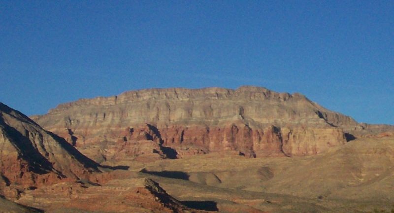
Colorado State Highway 82
Risk Factor: The road from Aspen is not for those who fear heights. Not only is it the highest paved lane in Colorado—12,100 feet above sea level at Independence Pass in the Rocky Mountains—it's also full of steep drop-offs, tight curves, and narrow stretches that can fit only one car at a time. For these reasons, the Colorado Department of Transportation closes down the route through Independence Pass each winter. Even if you make it out of the winding mountain roads, once you get near Cañon City on Highway 82, there's a trek across the soaring, 1,260-foot-long Royal Gorge Bridge. Towering 955 feet above the Arkansas River, it held the record for being the highest suspension bridge in the world until it was bested by China's Beipanjiang River Bridge in 2003.
**Why you might be tempted to drive it anyway: **Independence Pass is right on the Continental Divide, and at the summit you can find scenic overlooks that make the best use of the high elevation; you can also take a side trip to the ghost town of Independence . The Royal Gorge Bridge has its own attraction, a 360-acre amusement park that's currently being rebuilt after a 2013 fire but is expected to reopen in summer 2014.

Dalton Highway
Risk Factor: How harrowing is the drive along the Dalton Highway? It's so intense that they made a reality TV show about it. The fourth through sixth seasons of the History Channel's Ice Road Truckers focus in part on the Dalton Highway, a road built in the '70s to bring supplies along the Trans-Alaska Pipeline. (It was also featured in an episode of the BBC Two's Most Dangerous Roads .) Along the 414-mile route, drivers are subjected to freezing temperatures, gravel roads, avalanches, whiteout snowstorms, as well as a general lack of cell phone reception or service stations. There's a reason this drive is mostly attempted by truckers—and, even then, with lots of spare tires and at speeds slower than 55 mph.
Why you might be tempted to drive it anyway: Besides getting to say you've driven on the northernmost highway in the continent, taking the Dalton is the only way drivers can get access to the Brooks Range, where there's unspoiled landscape to be hiked, especially through the Gates of the Arctic National Park and Preserve .

Tail of the Dragon
Risk Factor: Talk about curves. The 11-mile stretch of US 129 at Deals Gap, starting at the North Carolina/Tennessee border, is said to have 318 curves. That exact number is probably just a legend, but it's a darned twisty road. The curves themselves have their own nicknames, and, with monikers like Pearly Gates, Brake or Bust Bend, and Gravity Cavity, you can tell these twists are dead serious.
Why you might be tempted to drive it anyway: Want to test your performance driving skills? The number of curves in the scenic highway makes it a popular stretch for motorcycle and sports car enthusiasts looking to flaunt the 30 mph speed limit. (Even if you don't want to take the wheel, the people watching is pretty great.)

Saddle Road
Risk Factor: A combination of vision-obscuring fog, narrow lanes, rough roads, and a series of one-lane bridges once made Hawaii's Route 200 so dangerous that some rental car companies would forbid customers from driving their cars on it. Much work has been done to widen the narrow roadway and re-pave the roughest portions, but the low visibility and single-lane bridges are still a problem.
Why you might be tempted to drive it anyway: The highway got its nickname, the Saddle Road, for being the "saddle" in between the Mauna Loa and Mauna Kea volcanoes , providing roadway access to the observatories that branch off of Route 200. The Mauna Kea State Recreation Area on Saddle Road offers views of the volcanoes as well as a picnic area.

Alex Erdekian

Jessica Puckett

California State Route 1
Risk Factor: Another one to avoid if heights are an issue — Highway 1 is known for its stunning coastal views and steep drop-offs from the California cliffs into the ocean. The winding two-lane highway also traverses numerous bridges, including the Bixby Bridge, which soars 280 feet above the Bixby Creek Gorge in Big Sur.
**Why you might be tempted to drive it anyway: **If you do the drive south-to-north, you can take advantage of being on the inside lane—away from those cliff edges—and still get to take in the impressive scenery.

Trollstigen
Risk Factor: If the monsters don't get you along this highway—the name literally translates to "Troll's Path"—the curves on this road certainly will. The route is known for its 11 hair-raising hairpin turns and steep, 9% gradient. Yet despite the dangers of the one-lane road, it's become a popular tourist attraction, hosting thousands of brave drivers every year before it closes each winter.
**Why you might be tempted to drive it anyway: **You definitely shouldn't take your eyes off this road while you're driving, but if you do you can catch a glimpse of the impressive Kongen (King), Dronningen (Queen), and Bispen (Bishop) mountains, or stop at the 1,050-foot Stigfossen waterfall.

North Yungas Road
Risk Factor: This route's nickname really says it all — sometimes, it's simply called "Death Road." And, with no guardrails along the 12-foot-wide roadway protecting drivers from a 2,000-foot plunge off a cliff, it's easy to see why. (To make matters more confusing, drivers drive on the left to better see the cliff's edge.) "Death Road" isn't just a nickname, either: It's estimated that the highway is a site of 200 to 300 deaths per year.
**Why you might be tempted to drive it anyway: **No one says you have to do it in a car. Cyclists have found it easier to manage the narrow lanes and steep curves, and the road often hosts tours of adventurous bike enthusiasts .

Stelvio Pass
Risk Factor: This highway is the second-highest paved road in the Alps (behind France's Col de l'Iseran), climbing to 9,045 feet with gradients as steep as 14%. But what really makes the drivers tremble is the 60 hairpin turns packed into just 15 miles. You can count them as you go along, as 48 of them are numbered and marked by stones along the way. The route achieved further infamy when former Formula One driver Stirling Moss drove off the road during an event.
**Why you might be tempted to drive it anyway: **For those spectacular Alpine views. Once you complete the pass, you can stop at Stelvio National Park , Italy's largest, to take in the mountain scenery.

Guoliang Tunnel Road
Risk Factor: For years, the village of Guoliang asked the government to build a highway that would connect them to the surrounding towns. After the government kept refusing, the village sent its 13 strongest to build one themselves. The DIY approach may seem quaint—until you have to drive on it. The two-way road is just 13 feet across with a steep drop off the cliffs to one side and, having been carved by hand, dips and twists at unexpected angles where the rock was easiest to remove.
**Why you might be tempted to drive it anyway: **The builders saw fit to include 30 "windows" of varying sizes in the quarter-mile-long tunnel. Depending on your feeling about heights, the views can be a reminder of the fall that could occur on the other side of the tunnel wall, or a window into a sweeping vista of China's landscape.

Tianmen Shan Big Gate Road
Risk Factor: Elsewhere in China, the Tianmen Shan Big Gate Road (also called the Tianmen Winding Mountain Road) is said to have 99 curves, symbolizing the nine palaces of heaven. But even if you expertly navigate all those swings, you still won't have reached the mountain's summit. There are also 999 stairs to climb before you reach the peak, where Heaven's Gate—a natural rock arch that was believed to be the link between the gods and the mortal world—awaits visitors.
**Why you might be tempted to drive it anyway: **You don't actually have to drive or do all that stair-stepping to get there. A cable car takes visitors directly to the top. (Shhh, we won't tell.)
This article was originally published January 2014.
**More road trips:
Best Drives: Iconic American Road Trips Worth the Gas Money
Ultimate Road Trips: Winter Driving Courses from Audi, Mercedes, and Porsche
How to Road Trip in France Like an NYC It Girl
Buckle up: Here are the most dangerous roads in America
Aaa estimates about 55 million people will travel more than 50 miles this thanksgiving, and among those travelers are about 50 million people who will drive..

Here are some of the most dangerous roads in America
Car crashes can occur on any street, road or highway in America, but some are statistically more dangerous than others. Here’s a list compiled by AAA of some of the most dangerous.
Car crashes can occur on any street, road or highway in the U.S. , but some are statistically more dangerous than others.
So, as nearly 50 million Americans prepare to head home after Thanksgiving , it's important to know where you should take extra precautions to ensure you arrive safely.
Here's a list compiled by AAA of some of the most dangerous roads in America .
HOW TO WATCH FOX WEATHER
Million Dollar Highway, Colorado

FILE - Circular elevated view of Colorado State Highway 550, known as "Million Dollar Highway," threads its way from Silverton to Ouray.
(Joe Sohm / Visions of America / Universal Images Group / Getty Images)
Colorado 's Million Dollar Highway offers some of the most breathtaking views in the country, but it's not for the faint of heart. Winding through Red Mountain Pass in the San Juan Mountains, the Million Dollar Highway climbs 11,000 feet above sea level and has cliffs and hairpin turns.
The Million Dollar Highway is officially known as U.S. Route 550, but according to local legend, it got its name after a woman said she would have to be paid $1 million to drive it again.
AAA says when you mix in some of Colorado's harsh weather, the Million Dollar Highway is one of the most dangerous roads in America, according to a list compiled by USA Today.
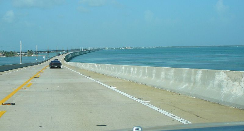
U.S. Route 1, Florida

FILE - Aerial view of U.S. Route 1 Overseas Highway to Key West, Florida.
(Visions of America / Joseph Sohm / UCG / Universal Images Group / Getty Images)
AAA says Florida doesn't have a ban on using a handheld cell phone while driving, and research looked into deaths on U.S. Route 1 between 2015 and 2019 and found Florida's section of the highway is one of the deadliest roads in America.
In total, 87 people died between those years.
The south end of the highway, known as the Overseas Highway, connects Miami to the Florida Keys and consists of miles of bridges many people find unnerving, according to AAA.
Lake Pontchartrain Causeway, Louisiana

FILE - Aerial view of Lake Pontchartrain Causeway.
(Jeffrey Greenberg / Universal Images Group / Getty Images)
The Lake Pontchartrain Causeway in Louisiana holds the Guinness World Record for the longest bridge over water at 24 miles long.
And when you get to the middle of the bridge, where there's no land in sight, many people get nervous – especially when the causeway becomes enveloped in fog . AAA says that sometimes the fog becomes so thick that local police must escort drivers across the bridge.
I-4, Florida

FILE - Tampa Bay-area residents and drivers fill the lanes on I-4 as they escape the high winds and floodwaters of Hurricane Ian with just a day left before the storm lands in Tampa, Florida, Tuesday, Sept. 27, 2022.
(Willie J. Allen Jr. / Orlando Sentinel / Tribune News Service / Getty Images)
AAA says Interstate 4 between Daytona Beach and Tampa, Florida , was once the deadliest highway in America , with roughly 1.41 deaths per mile on the highway.
According to AAA, this could be because the highway runs right through Orlando, which is a hotspot for tourists looking to visit Walt Disney World, Universal Studios or other attractions.
I-45, Texas

FILE - Houston, Texas, skyline at dusk and I-45 commuter traffic.
(Jeff Greenberg / Universal Images Group / Getty Images)
Interstate 45 in Texas is extremely congested, and AAA says the Galveston-to-Dallas section of the highway was recently named the deadliest road in America by Budget Direct.
They found that I-45 averages about 56.5 fatal crashes for every 100 miles of highway, noting that heavy traffic and driver complacency are to blame.
I-10, Arizona

FILE - Vehicles travel on Interstate 10 during rush hour in Phoenix, Arizona, on Thursday, April 22, 2021.
(Courtney Pedroza / Bloomberg / Getty Images)
Interstate 10 runs from Jacksonville, Florida, to Santa Monica, California, but AAA says the stretch of highway running through Arizona is extremely dangerous.
This is because the highway cuts through the desert, which leads to drivers speeding and driving aggressively.
Nearly 500 people were killed on I-10 in Arizona over a six-year period .
I-15, Nevada and California

FILE - Solitary touring cyclist cycling along Interstate 15 through Mohave County in Arizona and heading for Las Vegas, Nevada.
(Marica van der Meer / Arterra / Universal Images Group / Getty Images)
The 181-mile stretch of Interstate 15 between Las Vegas and Los Angeles isn't dangerous because of road conditions – it's because of the drivers on the highway.
In fact, one study checked out data over a 15-year period and found it to be the deadliest road in America.
This is because drivers often speed while traveling through the Mojave Desert, and they're likely coming or going from the excitement in Las Vegas. That same study found about one-quarter of crashes on that section of roadway involved a drunk driver.
I-285, Georgia

FILE - Highway signs showing I-285 in Georgia.
(Flickr.com / dougtone / FOX Weather)
Interstate 285 in Georgia is called "The Perimeter" because the 64-mile loop encompasses the city of Atlanta. In addition, AAA says that the highway connects all the other major highways in the region, leading to congested roadways.
AAA says Vox calculated the road's fatality rate and found it was 3.5 deaths for every 10 miles, which, at the time of the study in 2015, was the country's deadliest interstate.
U.S. Route 17, South Carolina

FILE - Route 17 in South Carolina.
Route 17 in South Carolina is one of the most scenic and breathtaking drives you can take in the Southeast , but it's also dangerous.
AAA says the road is filled with sharp turns and narrow lanes, and there's also a lot of wildlife that leads to a driving hazard when they cross the road.
One study named U.S. 17 in South Carolina one of the most dangerous roads in America during the summer.
James Dalton Highway, Alaska

FILE - View of Mount Sukakpak, 20 miles north of Coldfoot on the Dalton Highway.
(Jake Allen, Alaska DOT&PF / FOX Weather)
The James Dalton Highway was constructed in 1974 and stretches 414 miles through Alaska 's wilderness from Fairbanks to Deadhorse.
The road is mainly used to transport oil and cuts through some of Alaska's most treacherous terrain.
You may have heard of this highway before, too. Driving on this road is so dangerous that it was the focus of the TV show "Ice Road Truckers."
In addition to the road cutting through forests, steep hills and the Yukon River, what makes this road so dangerous is its remoteness, according to AAA.
There are only three towns along the entire 414-mile route, which includes a 240-mile stretch without any gas stations or rest stops.
Highway 2, Montana

FILE - Highway 2 in the Rockies of Montana.
(Dukas / Universal Images Group / Getty Images)
Montana 's Highway 2 stretches east to west across the northern end of the state and maintains a 70-mph speed limit – even when winding through some mountainous regions.
That means you're far away from any help should you need it.
In 2021, the average EMS response time in Montana was about 45 minutes , and that number climbs when EMS workers need to travel on Highway 2, according to AAA.
Road to Hana, Hawaii

FILE - Beautiful scenic view of the lush greenery on the road to Hana in Maui, Hawaii.
(Michael Siluk / Education Images / Universal Images Group / Getty Images)
You might think you're in paradise when you're in Hawaii and driving on Maui's Road to Hana , but you must be careful.
The 52-mile road connects Kahului to Hana on the eastern shoreline and offers beautiful views of mountaintops, forests and waves crashing on the shore.
But along the way, you'll also come across 620 turns and 59 narrow bridges, according to AAA. It can take drivers anywhere from 2 to 4 hours to make the journey, and Hawaii's tourism authority recommends drivers travel with a permitted tour company rather than making the drive themselves.

How interstate highways shaped America
The interstate highway system tells a story about a nation whose evolution both drove and was driven by something as seemingly simple as pavement.
- Transportation
- South Carolina
Moving can be hard, but U-Pack makes it easy. Get a quote and let's get moving.
Get a quote
We'll get you a price. No fees, no hassles.
We drive, you save
10 Most Dangerous Roads in the U.S.

Traveling the worst U.S. highways
An intricate system of roads, highways and interstates connects the United States. Whether you’re driving for business, pleasure or an out-of-state move, traveling long distances can be challenging. Some roads are less safe than others, so it’s important to know what to expect before you set off, especially if you’ve decided to turn your move into a family road trip .
We looked at data from AAA, Consumer Affairs and the National Highway Traffic Safety Administration to determine the 10 most dangerous roads in the U.S. We considered factors like curviest, deadliest, scariest, steepest and worst road conditions.
Note: For this post, we didn’t include roads in Hawaii.

Curviest roads in America
Pikes peak highway (colorado) .
Located just west of Colorado Springs in Cascade, Colorado, the Pikes Peak Highway Gateway is a 19-mile stretch of curvy mountain road. The toll road starts at an elevation of 7,400 feet and ends at 14,115 feet at the summit of the mountain. A round-trip journey takes approximately 2-3 hours, not including any sightseeing time.
The route is so popular with tourists during the summer that reservations are required from May 26 until September 30. Local authorities recommend that visitors have no heart or respiratory issues and travel in vehicles in good working order with at least half a tank of gas. The drive is not recommended for infants younger than 6 months old.
Tail of the Dragon at Deals Gap (Tennessee and North Carolina)
Want to navigate 318 curves in only 11 miles? Tail of the Dragon at Deals Gap, designated as US 129, is a popular destination for motorcyclists and sportscar drivers. The curvy road is bordered by the Cherokee National Forest and the Great Smoky Mountains with no intersections. Drivers are urged to pay attention, stay in their own lane and follow the strict speed limit of 30 MPH.
Deadliest U.S. interstates
Interstate 4 (florida) .
The 132-mile interstate connects Tampa to Daytona Beach, Florida. It’s often ranked on lists for most dangerous interstates due to the high fatality rate, which has been as high as 1.41 per mile during the past 10 years. The Florida Safety Council attributes the accident rate to the high concentration of tourists driving unfamiliar rental cars while looking at GPS devices.
Interstate 15 (Nevada and California)
The 181-mile stretch of straight roadway connecting Las Vegas and Los Angeles is in good shape, but drivers tend to speed through the open Mojave Desert. This interstate is often named one of the country’s most dangerous roads because of the high percentage of accidents involving drunk drivers coming from or going to Las Vegas.
Scariest routes
James w. dalton highway (alaska) .
Connecting the towns Livengood and Prudhoe Bay, this 414-mile gravel and dirt road travels through the remote wilderness of Alaska. You might be familiar with the highway if you’ve seen the television show “Ice Road Truckers.” Only rugged 4x4 vehicles are allowed on the road, which runs parallel to the Trans-Alaska Pipeline. From the halfway point of Coldfoot to the end of the road, there are no facilities for eating, lodging or refueling.
Lake Pontchartrain Causeway (Louisiana)
Located in the New Orleans metropolitan area, the Lake Pontchartrain Causeway connects Metairie to Mandeville. The Causeway comprises two parallel bridges crossing Lake Pontchartrain in southeastern Louisiana. At nearly 24 miles long, it holds the Guinness World Record for longest bridge over water (continuous).
The half-hour drive across The Causeway can be nerve-wracking for people who fear the water since dry land isn’t visible near the midpoint. Due to its location over the water, weather conditions can sometimes cause fog so thick that police escorts are needed to usher drivers across the bridge safely.
Steepest and highest highways
Bradford street (california).
Located in the Bernal Heights neighborhood in San Francisco, Bradford Street is the steepest in the city, with a grade of 41% at the top. It’s the steepest street in the continental U.S. that’s open to vehicles. A one-ton car set to roll from the top of the road could reach 60 MPH in under 8 seconds!
Mount Blue Sky Scenic Byway (Colorado)
This 28-mile stretch of Highway 5 in Colorado leads to Mount Blue Sky (formerly Mount Evans), about 60 miles west of Denver. It’s the highest paved road in the U.S., gaining almost 9,000 feet of elevation as you drive, topping out at 14,264 feet above sea level. The road is narrow in several areas with sudden drop-offs and no guardrails (to preserve the natural beauty). Driving the highway requires reservations, and it’s only open to cars from Memorial Day to Labor Day each year, weather permitting.
Worst road conditions
According to the Consumer Affairs report on U.S. Road Conditions, these continental states are known to have the worst road conditions. While the highways might not necessarily have more accidents than others, they do cause more wear and tear on vehicles.
Louisiana roads
Louisiana drivers spend an average of $658 per year on car maintenance directly related to bad street conditions. Of the 61,300 miles of public roads, 46% are considered poor or mediocre, with poor patch jobs and potholes being residents’ main complaints. Louisiana’s vehicle accident fatality rate is 1.42 per 100 million miles of travel, which is higher than the U.S. average of 1.11.
Rhode Island roads
Around 75% of Rhode Island’s major streets and 17% of its bridges are considered poor or mediocre. Drivers there spend an average of $833 per year on car maintenance related to bad road conditions. The state’s Department of Transportation cites lack of funding as the primary reason behind the shortfalls. Plus, the state coastline makes the highways susceptible to extreme weather and damage from salt water.
Will you be driving soon?
If you’re planning a long-distance move, U-Pack ® can help by transporting your things so you can travel in the comfort of your own vehicle. Get a free quote online or call 844-362-5303 844-594-3077 to speak to a moving consultant.
Have you driven one of these roads or another scary one? Tell us what it was like in the comments below.
View the discussion thread.
More articles you might like...

Should I Tip Movers?
Wondering if you should tip movers or how much to give them? Learn what’s expected and other ways to show…

How to Move Books
To keep your library safe during a long-distance move, check out these tips to protect your books in transit and…

Ultimate Guide to Apartment Moving: 10 Steps for Success
Check out our ultimate guide featuring a step-by-step plan for moving to or from an apartment and learn how U-Pack …
Looking for more articles?
View more articles
By continuing to use this site, you agree to our use of cookies .
We may earn money when you click on our links. Learn more .
Home > Moving
The 10 Most Dangerous Roads in the US

At a glance
Driving yourself and hiring a moving company to transport your stuff or driving a moving truck can be intimidating—especially while navigating backroads, traffic, extreme weather, and dangerous highways. In this article, we’ll point out some of the most dangerous roads you might come across during your moving road trip to make the drive as smooth as possible.
America’s most dangerous roads
The most dangerous roads in the us, tips for safe driving, the takeaway.
Planning on hiring a car shipping company to navigate the road for you? Make sure you compare costs from various companies and look into auto transport insurance .
From cliffside highways to busy interstates, these roads are some of the most dangerous to navigate.
1. Million Dollar Highway – Colorado
The Million Dollar Highway is a 25-mile stretch of road along the San Juan Mountains between Ouray and Silverton, Colorado . While this road has fewer traffic fatalities than other major highways, it can be terrifying to traverse—especially along the Red Mountain Pass. Cliff edges with no guardrails have earned this narrow two-lane road the nickname “Highway to Hell.”
2. Interstate 4 – Florida
With millions of tourists flocking to Florida , and especially Orlando every year, the “theme park capital of the world” is also one of the most traffic-dense and dangerous places to drive. A recent study named I-4 the deadliest road in America, with 150 deaths between 2016–2019. In particular, the 132-mile stretch between Daytona Beach and Tampa had the most deadly crashes.
3. Taconic State Parkway – New York
The Taconic State Parkway is the most dangerous road in New York . This historic highway is just over 100 miles long and has hazardous intersections, inclement weather, and narrow lanes. The Taconic State Parkway begins north of New York City and ends in Chatham.
4. Interstate 5 – Southern California
The I-5 is a major interstate stretching from San Diego County to the Canadian border in Washington State. Due to large populations, bad traffic, and tourist attractions, this is an especially dangerous highway in Southern California . In fact, in 2019, there were nearly 20,000 road accidents in San Diego alone.
5. Route 285 – West Texas
While U.S. Route 285 spans 865 miles over three states (Colorado, New Mexico, and Texas), one stretch in West Texas has earned the nickname “Death Highway.” Many recent fatal crashes were caused by large trucks that were carrying supplies to and from the Permian Basin, a major oil field.
Other dangerous highways in Texas
If you’re traveling through Texas , you’ll also want to look out for distracted drivers in areas like Loop 1604 in San Antonio and Interstate 20 in the Dallas Fort Worth area. Both of these roads see car accidents almost daily.
6. Rhode Island – Interstate 95
Although Rhode Island is the smallest state in the US, it is also home to one of the most dangerous highways. Along I-95 in Rhode Island, several highway exits have sharp, sudden curves and poor road design, causing dozens of crashes and several traffic fatalities per year.
7. James Dalton Highway – Alaska Dalton Highway
You may have seen the James Dalton Highway featured on “Ice Road Truckers,” or “World’s Most Dangerous Roads.” This 414-mile route is laden with extreme road conditions, isolation, and only a few gas stations along the way. If you happen to be moving along Dalton Highway in Alaska, pack food and survival supplies in case of an emergency.
8. Tail of the Dragon at Deals Gap Road – North Carolina
This 11-mile stretch of road is famous for its breathtaking scenery and dangerous twists and turns. Bikers and thrill-seekers flock to Deals Gap to test their limits, resulting in frequent auto accidents. If you’re traveling through North Carolina , proceed through this section of US 129 with caution.
9. Mt. Rose Highway – Nevada
While Las Vegas roads can be dangerous, one of the scariest roads in Nevada is Mt. Rose Highway. This state route features gorgeous scenery between Reno and Lake Tahoe, but it can be treacherous in the winter. Be prepared with tire chains or snow tires, and watch for sudden curves in the road.
10. Highway 17 – South Carolina
Highway 17 in South Carolina is one of the most dangerous roads for summertime travel. This gorgeous coastal highway saw 82 traffic fatalities between 2015 and 2017, likely due to the influx of tourists visiting the east coast (Myrtle Beach and Charleston) during the summer months.
Dangerous roads around the world Nicknamed “Death Road,” North Yungas in Bolivia is considered the most dangerous road in the world. Road length: 43 miles Road width: 10 feet
Getting ready to move?
You may be unable to avoid every dangerous highway on this list, and you certainly can’t avoid everyday traffic dangers. To make your move as safe as possible, keep these safe driving tips in mind:
Make a road trip playlist
Changing music choices is one of the most common pitfalls of distracted driving. Try to decide beforehand what you’ll listen to and save any changes for pit stops along the way.
Update your car insurance
Make sure you have up-to-date car insurance, including comprehensive coverage, and keep necessary documents in your car or on your phone.
Pull over if you’re sleepy
You may be tempted to power through, but it is always a good idea to pull over for safety. Drowsy drivers are huge contributors to fatal crashes.
Drive defensively
Using extra caution is always a good idea on a road trip. Leave extra room between your car and fellow drivers, brake early, let aggressive drivers pass, and don’t let road rage get the best of you.
Words from a wise mom: “Just imagine everyone around you is drunk”—or in other words, you never know what another driver is capable of. So make it your responsibility to drive extra safely!
You might encounter distracted drivers, traffic jams, and poor road design during your moving road trip . And while you may not be able to avoid all the dangers of the road, you can try your best to plan ahead, practice safe driving habits, and watch out for these infamous highways.
Maybe you’re not in the mood to drive a moving truck across the country on one of these treacherous roads. We don’t blame you. Learn about hiring a professional moving company for your long-distance move.
Dangerous American roads FAQ
What is the most dangerous road in america.
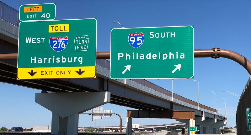
Regarding the most fatalities per 100 miles, Interstate 95 (I-95) is considered the most dangerous road in America.
What are the top 10 most dangerous roads in America?
According to navigation software findings , the top 10 most dangerous highways based on fatal accident per mile in America are:
- Interstate 4
- Interstate 45
- Interstate 17
- Interstate 12
- Interstate 30
- Interstate 95
- Interstate 19
- Interstate 85
What is the scariest road in America?
The scariest road in America is probably the James Dalton Highway in Alaska. A combination of severe weather conditions and isolation makes this 414-mile road pretty terrifying.
What state has the most dangerous roads?
Based on total traffic fatalities, the states with the most dangerous roads are also the most populous: Texas, California, and Florida. Judging safety by road maintenance and quality, Rhode Island has the worst roads in the country.
Recommended resources
- Best Moving Companies of 2022
- Best Moving Container Companies
- Best Truck Rental Companies
- Best Car Shipping Companies
Moving Resources
Professional Moving
Container Moving
Car Shipping
Self-storage
Local Professional Movers
Truck Rental
Home Services
Connect with Us
Partner with Us
Sign up for our moving guide!
Get emails with discounts, tips, and checklists — to guide you through every step of your move.
By signing up you agree to our Terms of Use and Privacy Policy.
All content © 2024 Move.org. All rights reserved. | | Privacy Policy | Terms of Use | Disclosure
- South Africa
- Turkmenistan
- South Korea
- Philippines
- Timor Leste
- Afghanistan
- Saudi Arabia
- United Arab Emirates
- Northern Ireland
- Isle Of Man
- Bosnia and Herzegovina
- North Macedonia
- Liechtenstein
- Netherlands
- Switzerland
- Czech Republic
- Antigua And Barbuda
- British Virgin Islands
- Cayman Islands
- Dominican Republic
- Puerto Rico
- Saint Barthelemy
- Saint Kitts and Nevis
- Saint Lucia
- Saint Martin & Sint Maarten
- Trinidad And Tobago
- Turks And Caicos
- US Virgin Islands
- Falkland Islands
- French Guiana
- El Salvador
- United States
- New Zealand
- Papua New Guinea
- Cook Islands
- French Polynesia
- Accessories
- Bags & Backpacks
- Horseback Riding
- Photography
- Maintenance
- Airport Hotels
- Bed & Breakfast
- Budget Hotels
- Business Hotels
- Family Friendly Hotels
- Gay Friendly Hotels
- Luxury Hotels
- Pet Friendly Hotels
- Pool Hotels
- Romantic Hotels
11 Most Dangerous Roads in the US
- 11 Most Dangerous Roads in…

Although unchanging and consistent open roads can be very relaxing to drive on, others require a bit more concentration and attention. While there are thrilling yet terrifying roads all over the world, there are lots of roads that offer adventure right in the United States. Now, the most dangerous road in the US, which ranges from Maui to Colorado, might not be as extreme as Bolivia’s “death road.” However, when it comes to highway deaths per capita, the US is much more dangerous than most northern European countries. In fact, that number is 11 highway deaths per 100,000 population annually. That’s almost three times the death rate of the United Kingdom! The deadliest stretches of roads might be very scenic and picturesque, but you need to be careful out there. To that end, here are the 11 most dangerous roads in the US.
Table of contents
Highway 17, south carolina, highway 550, colorado, james dalton highway, alaska, hana highway, hawaii, i-285, atlanta, highway 160, colorado, kahekili highway, hawaii, i-10, arizona, highway 2, montana, i-15, nevada, highway 1, florida.
Highway 17 in South Carolina is easily the most dangerous road in the US. The magnificent and stunning scenery, which features thick canopies of trees in some stretches, is very deceiving. That’s because the highway becomes especially dangerous in South Carolina, where it has a host of blind and sharp curves. What’s more, many wildlife, such as mountain lions and deer, tend to suddenly jump right out of the canopy and in front of cars. The sharp turns, blind curves, and narrow lanes have resulted in death every two miles.
Did you know that Highway 17 passes through the charming coastal city of Myrtle Beach? If you’re making a long road trip, then you might want to consider staying at the Best Hotels in Myrtle Beach .

The 25-mile stretch (40 km) of Highway 550 in the southwestern part of the state is one dangerous road in Colorado. Known unofficially as the “Million-Dollar Highway,” the highway connects some of the Best Places To Visit In Colorado . For instance, it connects the antique tourist towns of Silverton and Ouray, one of the Best US Winter Vacation spots. Then, it reaches elevations of 11,000 feet as it passes through the San Juan Mountains’ Red Mountain Pass. However, the scariest part of this highway is that it doesn’t have guardrails since they impede removing avalanche and snow debris. What’s more, there aren’t any shoulders on a greater part of this section too. So, weaving off the road translates to plunging thousands of feet along the side of the mountain.
There are conflicting stories about the origin of the nickname “Million Dollar Highway.” The most popular one is that it’s the cost of paving or building the road. It includes the amount of silver and gold excavated when the highway was built in 1926. Yet another local folklore says that the name came about because an early traveler said she’d have to be paid a million dollars to drive it again!
The James Dalton Highway is not only the most dangerous road in the US but one of the World’s Most Dangerous Roads ! To add to the danger, it traverses an eerie distance of 666 km (414 mi)! Considered one of the world’s most isolated routes, the highest extends from Elliott Highway to Deadhorse near the Arctic Ocean. Since it supports the Trans-Alaska Pipeline System, the road is mainly used by truck drivers for making it from and to the northern Prudhoe Bay Oil Fields. However, harsh weather, rugged terrain, and next-to-nothing visibility make this road very treacherous. Furthermore, huge portions of the road aren’t paved either, so it becomes very icy and slippery mid-winter. The worst part is that the surrounding tundra also sees lots of avalanches, adding to the danger.
The highway is so isolated that there are just three towns that lie along the route. Moreover, there are no gas stations, restaurants, or even medical facilities. That’s why truckers and drivers are advised to bring lots of safety and survival gear as well as supplies. It’s no surprise that the James Dalton Highway has featured on “World’s Most Dangerous Roads” on the BBC channel.
The Road to Hana is one of the most popular and scenic drives in Maui, Hawaii. Part of Routes 36 and 360, the 64-mile-long (103 km) Hana Highway is also infamous for a significant number of accidents. Connecting Kahului and Hana, the highway is wider than the other dangerous road in Maui, Kahekili Highway. But, it has many one-way bridges, along with curves and hairpin turns. Thus, it can be very difficult to navigate, especially since the road is very popular and filled with tourist drivers. What’s more, there are many places with vegetation and a wall of rocks on one side and steep cliffs (sans guardrails) on the other. To that end, only experienced and calm drivers should be heading along this road – and that too only during the day.
The I-285 around Atlanta, known as the Perimeter, is the most dangerous road in the US. The highway circles the city in one huge 63-mile (101 km) loop, thus connecting many highways and interstates running into the city. In fact, it crosses with the I-85 just northeast of the city, making for one of the World’s Most Confusing Interchanges . So, I-285 is full of merging, turns, and large trucks and tractor-trailers, which means that it’s extremely dangerous. In fact, the highway had fatality numbers of 3.5 fatal crashes every 10 miles in 2013! The heavy traffic only adds to the danger, so drivers need to be very safe while navigating this highway.
What doesn’t help is that Atlanta is said to be one of the Most Dangerous Cities In The United States !
Highway 160 is easily the most dangerous road in Colorado. Located in the San Juan Mountains, the highway leads to Wolf’s Creek Pass , which sits at an elevation of 10,850 feet! There’s a particularly steep section that’s full of tight switches and hairpin turns that’s very difficult to navigate. Add to that a propensity for nasty weather, and this highway is very, very dangerous. During winters, the ice and snow make it all the more difficult to navigate. Even summers see a lot of snow here, which is why most over-the-road truck drivers avoid Colorado in entirety during the winter months. That’s why one of the most famous pieces of advice of the state’s transportation department is “Beware of the Wolf!”
There’s no doubt that Kahekili Highway is the most dangerous road in the US. Also known as State Highway 340, it also happens to be one of the most dangerous roads in Maui. For about 20 miles (32 km) between Wailuku and Kapalua, you need to navigate rocks on one side and steep cliffs on the other. The road might allow for two-way traffic and be paved reasonably well, but most of it is a single-lane one. Plus, it has pull-offs in certain areas to allow vehicles to pass each other. Now, that can be a dangerous prospect, especially if some over-enthusiastic driver is coming over at high speed. That’s why most of the trip needs to be done at a lower speed while navigating winding turns without guardrails.
In fact, it’s not uncommon for the road to be closed when debris or an accident blocks the highway. The fact that many motorists have been killed with their bikes falling off the side makes it all the more unsafe.
The I-10 runs the entire width of the country, and it even connects some of the Top Things To Do In Arizona . However, the 150-mile (241 km) stretch between Phoenix to the California border is especially dangerous. In fact, 85 deaths were reported in this stretch of the road in a single year in 2010. The section runs through a lightly populated desert and sees a lot of traffic. But, factors such as lack of sleep and tiredness have sent many drivers either straight into oncoming traffic or the desert. The mountainous terrain and hairpin curves only add to the dangerous nature of the road, which requires a lot of attention for driving on.
Highway 2 in Montana is the most dangerous road in the US, with the highest fatalities. The highway crosses through the northern, and thus, the remotest part of the state, with very few towns in between. That’s one of the reasons why Montana is known as one of the most dangerous states for driving overall. In fact, some national transportation agencies have asserted and found that rural roads are more dangerous than urban ones. The reasons include long transportation times, almost 80 minutes, for ambulances to get accident victims to hospitals. Furthermore, the sparse traffic only translates to faster driving, thus resulting in more accidents where drivers lose control of the vehicle.
Millions of people drive back and forth annually from Los Angeles in Southern California to Las ‘Sin City’ Vegas in southern Nevada. However, this 180-mile (290 km) stretch has seen more fatalities than anywhere else in both states. The kicker? Half of those killed are usually not wearing seatbelts, zipping down the highway. However, commercial truck drivers and AAA who drive the route say that there are other reasons too. These include distracted driving due to the scenery as well as drinking and driving. In fact, in the 15 years before 2010, 1,069 people had been killed on the road.
In 2017, one of the World’s Most Scenic Drives was also ranked the most dangerous road in the US – that’s Florida’s Highway 1. The road has the highest fatal crash rates, with 1,079 people having died on the road in the previous decade alone. The highway, the longest north-south one in the country, runs along Florida’s east coast for about 545 miles (877 km) through 13 counties. During the summer months, when the traffic skyrockets, so do the fatalities. This highway runs through some major Floridian cities, including Key West, Miami , Fort Lauderdale , and Jacksonville.
Author: Jacko Martinez
As a gay travel blogger, I am passionate about exploring the world and sharing my experiences with readers. Through my travels, I aim to highlight destinations and experiences that are welcoming and to the LGBTQ+ community. Whether I'm exploring the vibrant nightlife of gay-friendly cities like Berlin and Barcelona, or relaxing on the beaches of Mykonos and Phuket, my blog offers insights into the best destinations for LGBTQ+ travelers. But my blog is more than just a travel guide - it's a celebration of diversity and inclusion. I believe that travel has the power to bring people together and break down barriers, and I strive to showcase the unique cultures, people, and perspectives that make each destination special. From queer history tours to LGBTQ+ events and festivals, I seek out the experiences that celebrate and embrace the diversity of the community. Through my blog, I hope to inspire others to explore the world and embrace their true selves, no matter where their travels take them. So whether you're a member of the LGBTQ+ community or an ally, my blog is your guide to the best destinations, experiences, and perspectives in the world of gay travel. Join me on my journey as we explore the world, one inclusive adventure at a time.
Mapped: The Most Dangerous Times to Drive in America
Sometimes, it’s prudent to put the brakes on before you even make it to your car.
According to statistics, there are an average of about 100 fatal road accidents in the United States every single day. But nobody takes the “average” trip: where and how you drive makes a significant difference to your odds of getting home safely . For instance, you are four times more likely to be involved in a collision if you drive while using a phone.
And your probabilities of evading an accident are also higher if you drive at particular times of the day, week, and year — and these factors, in turn, vary from state to state. To help America’s roadway users keep those roads a little safer, The Clunker Junker team used data from the National Highway Traffic Safety Administration to determine the safest times to drive in the United States — and the hours, days, and months when it’s most reasonable to leave the keys in your pocket.
Table of Contents
Key Findings
The most dangerous hours to drive in america, the most dangerous times to drive by state, the most dangerous times in the week to drive in america, the most dangerous months to drive in america, methodology.
- An average of 5.57 fatal collisions take place between 9 and 10 pm, making it the most dangerous time to drive.
- 4 – 5 am is the safest time to drive, with an average of 2.34 fatal collisions across the United States during that period each day.
- Saturday is the most dangerous day to drive, with an average of 4.68 fatal accidents per hour, peaking at 7.08 between 9 and 10 pm.
- September is the most dangerous month to drive (106.48/day), and March is the safest (80.95).
- Coastal U.S. states tend to be more dangerous in the evenings, while central states are most dangerous in the afternoon.
Poor visibility, tiredness, and driver impairment can all make roads more dangerous, especially at night. Data from the National Highway Safety Administration indicates that the highest amount of fatal accidents occur between 9 pm and 10 pm, with an average of 5.57 accidents daily. Statistically, you are safest between 4 am and 5 am, where lighter traffic conditions cause 2.34 deadly accidents per day.

The Centers for Disease Control (CDC) lists road traffic accidents as a leading cause of death among people aged 1-54 in the United States, recommending safe and careful driving at all times. However, statistics show that certain times of day put motorists at higher risk of fatal accidents.
In Texas, 223 deadly crashes occur on average each year between 9 pm and 10 pm, with the state’s department for transportation reporting a 15% increase in fatalities in 2021.

According to the Association for Safe International Road Travel, over 46,000 people lose their lives in a traffic accident in the U.S. each year. According to our research, Saturday evenings are statistically the most dangerous. 7.08 fatal accidents per hour occur on average between 9 pm and 10 pm across the country.

Summer road trips are a ritual in America, with drivers using their vacation time to drive across the country. However, official traffic safety data reveals that the weeks between Memorial and Labor Day are the most dangerous for fatal accidents. 106.48 crashes with a death occur on average each day during September, making it the deadliest month on the calendar on U.S. roads.

The Clunker Junker sourced fatal accident data from the National Highway Traffic Safety Administration ( NHTSA ) and grouped the data by hour of day (nationally and on a state-by-state basis), weekday and month.
The Clunker Junker team also determined the top ten days of the year with the most accidents.
The data was gathered in January 2023.

You need to correlate time of day to number of cars on the road!

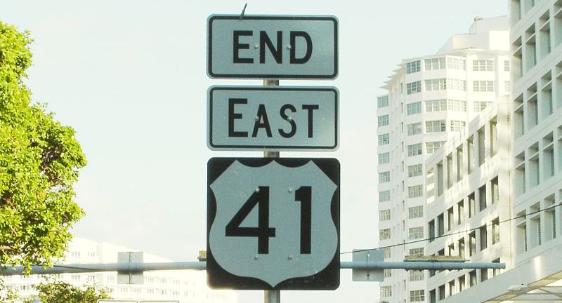
15 Most Dangerous Roads In America
Interstate 95 (I-95)
U.S. Route 1 (US-1)
Interstate 10 (I-10)
Interstate 75 (I-75)
U.S. Route 41 (US-41)
Interstate 40 (I-40)
Interstate 80 (I-80)
Interstate 5 (I-5)
U.S. Route 2 (US-2)
State Route 99 (SR-99)
Interstate 20 (I-20)
Interstate 35 (I-35)
Interstate 15 (I-15)
U.S. Route 6 (US-6)
Interstate 70 (I-70)
11 Secret Islands In The U.S. You Never Knew Existed
8 Hidden Gem National Parks To Explore In 2024

More From Bon Voyaged

These Are The Top Ten Holiday Destinations for 2020

Why Abu Dhabi Should Be On Your Travel Radar

National Geographic Releases its Annual Top 25 Destinations

Brightline Reveals Orlando-Miami Train Route Information

Oh Goody! A Peppa Pig Theme Park is Coming to…

Can You Guess the Most Visited City of 2019?

Niyama Private Islands Announces Surf Residency with Brad Gerlach

Princess Cruises Announces “Love Boat” Themed Cruise!

United to Add Self-Service Snack Bars
Los Angeles Stay-At-Home Orders May Extend Through August

Texas Officials Warn Residents Not to Travel to Mexico This…

Disney World Announces New Florida Resident Ticket Deal
- Last Minute
- TERMS OF USE
- PRIVACY POLICY

30 unforgettable weekend getaways in the USA

30 islands ranked by their highest point

These historic buildings were demolished... But why?

Countries where you have to pay to be a tourist

The best bike trails in each US state

National Geographic’s top 30 travel destinations in 2024
© Shutterstock
0 / 30 Fotos
Connecting Los Angeles to Las Vegas, the I-15 is largely filled with gamblers dreaming of big winnings on the way east, and disappointed losers on the way back. It's also filled with drivers taking advantage of the long stretches of largely open roads to push their cars to the limit.
1 / 30 Fotos
Mostly used to transport oil and gas, the Dalton Highway first opened in 1974. The road is incredibly remote, with only three towns along its entire 414-mile (666-km) path from Fairbanks to Deadhorse. Car rental companies don't generally allow their cars on this road, and helicopters make twice daily patrols to look for accidents or breakdowns.
2 / 30 Fotos
Contained entirely within Arizona, running from Flagstaff to Phoenix, this road is just under 145 miles (234 km) in length, but it averages 0.84 deaths per mile!
3 / 30 Fotos
Stretching along Maui from Kahului to Hana, although this highway is only about 52 miles (84 km), an uninterrupted car trip takes about 2.5 hours to drive. This is largely because the highway is very winding, narrow, and passes over 59 bridges, of which 46 are only one lane wide.
4 / 30 Fotos
A 221-mile (356-km) highway, Route 17 has an abundance of sudden curves, narrow lanes, and the occasional wildlife crossing, which makes it a dangerous road.
5 / 30 Fotos
Running 545 miles (877 km) from Fort Kent, Maine, down to Key West in Florida, Route 1 is a mostly straight route. It has had more than 1,000 fatal crashes over the course of a decade, making it one of the deadliest roads in the country.
6 / 30 Fotos
Among the longest highways in the US, running from Florida to California, the I-10 has a 391 mile-section (630 km) that runs through Arizona that is the deadliest. With extensive straightaways, those with a need for speed tend to exploit this highway.
7 / 30 Fotos
Connecting Galveston to Dallas, a recent study found the I-45 suffers, on average, 56.5 traffic fatalities per 100 miles of road.
8 / 30 Fotos
This highway runs through Orlando, which means it tends to be filled with excited rental-car drivers looking to meet Mickey Mouse. That's a recipe for distracted driving.
9 / 30 Fotos
Running from the Canadian border all the way down to Mexico, the US-83 goes through Texas, Oklahoma, Kansas, Nebraska, and the Dakotas. In Texas, it's particularly dangerous, averaging 26 fatal crashes each year. That's one every other week.
10 / 30 Fotos
With a scenic open road, extending approximately 666 miles (1,072 km) east to west through remote parts of the Treasure State, the speed limit here is often ignored by drivers.
11 / 30 Fotos
This 64-mile (102-km) highway loop suffers severe congestion, especially due to big-rig trucks, and confuses drivers with its sharp curves and complex interchanges.
12 / 30 Fotos
Those headed south to New Orleans will encounter this 24-mile-long (38-km-long) bridge, over nothing but water. Occasional fog makes the trip especially hazardous.
13 / 30 Fotos
While you'll get stunning views of the San Juan mountains, the steep cliffs by this highway can unfortunately be unsettling to casual motorists. The occasional rock slide and inclement Colorado weather can make this a dangerous ride.
14 / 30 Fotos
Though it travels from Los Angeles all the way to Tumwater, Washington, the portion of Route 101 that runs through Oregon, known as the Oregon Coast Highway, is especially dangerous. It averages 34 fatal crashes a year over the course of its 363 miles (584 km).
15 / 30 Fotos
Running from Maine to Florida, the I-95 goes through a lot of cities along its 1,915-mile (3,096-km) path. The interstate is actually the most dangerous highway in Connecticut, Rhode Island, North Carolina, and South Carolina.
16 / 30 Fotos
Highway 99 runs through California's Central Valley, spanning 424 miles (683 km) from Wheeler Ridge north to Red Bluff. The highway averages 0.62 fatal crashes per mile.
17 / 30 Fotos
The second-longest interstate in the US, the I-80 runs from Teaneck, New Jersey, all the way to San Francisco, across 11 states and 2,899 miles (4,668 km). It's also the most dangerous road in Nebraska, Wyoming, Pennsylvania, Iowa, and Nevada. Each of those states has an average of 16 fatal crashes each year on their section of the interstate.
18 / 30 Fotos
The I-65 runs 887 miles (1,428 km) from Gary, Indiana, to Mobile, Alabama. It averages 0.48 deaths per mile overall. It's the most dangerous road in Alabama.
19 / 30 Fotos
The I-24 runs through four states as it stretches 316 miles (509 km) from Illinois to Tennessee. In 2019, it saw 39 fatal accidents, which equates to 12.3 fatal accidents per 100 miles.
20 / 30 Fotos
Also known as the Long Beach Freeway, the I-710 is one of the deadliest roads in the US. Running 23 miles (37 km) long, there were 15 fatal accidents in 2019.
21 / 30 Fotos
Running through Florida, US Route 192 is a short 75-mile (120-km) highway, but it's still dangerous. The road averages 0.87 deaths per mile.
22 / 30 Fotos
Running an eerie 666 miles (1,071 km) from Alabama to Virginia, the I-85 saw 87 fatal accidents in 2019. That's the equivalent of 13.1 fatal accidents per 100 miles.
23 / 30 Fotos
Interstate 35 runs for 1,569 miles (2,525 km), from Duluth, Minnesota, to Laredo, Texas. The road averages 0.48 fatal crashes per mile, with an especially dangerous patch in Austin, Texas.
24 / 30 Fotos
US Route 2 runs from Washington to Michigan, and it's the country's northernmost east-west route. The stretch of highway that runs all the way across Montana is especially dangerous, as it has more fatal crashes than any other road in the state. And because of the remote landscape, the average arrival time for an ambulance to get to a crash is 80 minutes.
25 / 30 Fotos
Spanning from Michigan to Florida, the I-75 cuts through Detroit, Cincinnati, Atlanta, Tampa, and Miami. It's ranked third for the number of fatal accidents occurring in rainy or snowy weather.
26 / 30 Fotos
The I-40 runs from Barstow, California, to Wilmington, North Carolina, covering a distance of 2,555 miles (4,114 km). Across the entire highway, there are an average 0.43 fatal crashes per mile, and it's the most dangerous highway in California, Arizona, New Mexico, and Tennessee.
27 / 30 Fotos
Running from Van Horn, Texas, to Jacksonville, Florida, this 1,633-mile (2,628-km) highway is especially dangerous in Louisiana. With an average of 27 fatal crashes every year, it's the most dangerous road in the state.
28 / 30 Fotos
Running from Wichita Falls, Texas, to Saint Louis, Missouri, the I-44 averages 0.41 fatal crashes per mile of its 633-mile (1,024-km) length.
Sources: (Forbes) (Best Life)
See also: These are the states with the worst drivers in the US
29 / 30 Fotos
Shutterstock
These are the most dangerous roads in the US
What are the most dangerous roads and interstates in the country?

25/03/24 | StarsInsider
TRAVEL Driving
W ith 4.19 million miles (6.74 million km) of roads, the US is a country built for driving. However, with that many routes to ride on, you can be sure that some roads are going to be less safe than others. In fact, roughly 36,000 people die on American roads each year. And while you can't blame the roads alone, there are certainly some that host more than their fair share of fatal accidents.
With this in mind, click on to discover the most dangerous roads in the US.
RECOMMENDED FOR YOU

The most scenic roads in the US

How many countries can you visit in one day?

Why are geoparks so significant?

Europe's best beaches

Google’s top travel destinations in 2024 for Americans

The least visited countries in the world

The history of road travel via motorways, highways, and freeways

Discover the highest natural elevations in each US state

Sustainable travel: tips and tricks for the eco-conscious explorer

Why it's taken over 140 years and counting to build Spain's biggest church

American cities that changed their names

The most expensive neighborhood in every state

The world's most beautiful streets

30 things to do in Europe at least once in your life

The best (and worst) airports in the world in 2024

These are the 30 coolest streets in the world right now

Countries with the lowest rates of crime, ranked

The countries with the largest forests on earth

American cities that look and feel like Europe

30 things to do in the US at least once in your life

Conquering the continent: your US to Europe travel hacks guide

The best hiking trails in the USA

Visit these famous landmarks before they disappear

Would you visit these nuclear testing sites?

The saltiest lakes in the world (you won’t guess the Dead Sea’s position)

Essential tips for solo travelers

Quirky American city and town slogans

Islands of India you probably haven't heard of

Tips and trivia to enjoy the Japanese cherry blossom season
CELEBRITY Relationships
These celebrities have dated regular people
LIFESTYLE Throwback
Which hairstyle was in fashion the year you were born?
LIFESTYLE Catholicism
Slaves who became Catholic saints
LIFESTYLE Home remedies
Can spearmint tea clear acne?
LIFESTYLE Putin
After 50 years, Lenin's body can still be seen in Moscow
FOOD Fine dining
The best restaurants in the world in 2024
LIFESTYLE Emotions
How to be more emotionally available in your relationships
TRAVEL Nations
LIFESTYLE History
The best (and worst) vice presidents in US history
LIFESTYLE Emergency
What to pack in case of a war outbreak
© 2024 Stars Insider. All rights reserved..

Don’t miss out...
on the latest TV shows, movies, music, and exclusive content from the entertainment industry!
- Work & Careers
- Life & Arts
Become an FT subscriber
Try unlimited access Only $1 for 4 weeks
Then $75 per month. Complete digital access to quality FT journalism on any device. Cancel anytime during your trial.
- Global news & analysis
- Expert opinion
- Special features
- FirstFT newsletter
- Videos & Podcasts
- Android & iOS app
- FT Edit app
- 10 gift articles per month
Explore more offers.
Standard digital.
- FT Digital Edition
Premium Digital
Print + premium digital, weekend print + standard digital, weekend print + premium digital.
Today's FT newspaper for easy reading on any device. This does not include ft.com or FT App access.
- 10 additional gift articles per month
- Global news & analysis
- Exclusive FT analysis
- Videos & Podcasts
- FT App on Android & iOS
- Everything in Standard Digital
- Premium newsletters
- Weekday Print Edition
- FT Weekend Print delivery
- Everything in Premium Digital
Essential digital access to quality FT journalism on any device. Pay a year upfront and save 20%.
- Everything in Print
Complete digital access to quality FT journalism with expert analysis from industry leaders. Pay a year upfront and save 20%.
Terms & Conditions apply
Explore our full range of subscriptions.
Why the ft.
See why over a million readers pay to read the Financial Times.
International Edition
The Spookiest Road Trips in the United States
Astrid was the Senior Special Projects Editor at TripSavvy.
:max_bytes(150000):strip_icc():format(webp)/Astrid-Taran_WebReady-1-cbabb21bbf364534a230dbedf5b6a785.jpg "dangerous road trips in america")
Summer is finally over, and with crisp air, vibrant fall colors , and pumpkin spice lattes, comes the arrival of every Halloween lover’s favorite time of year: spooky season. Autumn may be the perfect time to hit the road for leaf-peeping, cider trails, and wineries, but as the fall chill sets in and the crunch of dead leaves collect on the ground, it’s also the best time of year to hop in the car and scare yourself silly.
The good news for horror enthusiasts is that there’s no need to travel to Trannsylvania to visit some seriously spine-tingling destinations. From Salem, Massachusetts, to Alcatraz Island, the United States is full of haunted history and creepy legends. So why not take advantage? After all, with plenty of frightening things going on in the world these days, it’s much more fun to focus on ones in the past or in your imagination.
Salem to Boston
Undoubtedly the most well-known spooky destination in the United States, Salem, Massachusetts , is where this route begins. Immortalized by the witchcraft hysteria of 1692, history buffs and Halloween lovers alike will enjoy a visit to the Salem Witch Museum to learn about the infamous events that took place there, as well as the Witch Trials Memorial, where you can remember the 20 young victims of the trials. Next, head north to Dogtown in Gloucester, a mysterious ghost town that became a hotspot for vagabonds after it was abandoned in the 1800s. The townspeople were rumored to practice witchcraft; to this day, you can find odd words and phrases—“Help Mother” being one of them—carved into boulders in the vicinity.
Head southwest to Fall River to see the infamous Lizzie Borden house , where America’s most gruesome axe murders took place. It was here that Lizzie Borden was accused of butchering her father and stepmother in broad daylight, though the case has never been solved. Nearby, take a stroll through Freetown-Fall River State Forest , also known as the "The Cursed Forest of Massachusetts.” Legends surrounding this forest include UFO sightings, witchcraft and human sacrifices, ghostly orbs, unexplained disappearances, and even stories of a race of troll-like creatures who call the forest home. End your trip at Boston’s Cutler Majestic Theater. Numerous ghost sightings have been reported here, including sightings of stagehands and theater patrons from centuries past still sitting in their seats, waiting for a show.
Philadelphia to Evans City
This frightening road trip starts at one of the country’s most infamous haunted destinations, the Eastern State Penitentiary in Philadelphia. This famous prison, which once held criminals along the likes of Al Capone, was known for its extreme approaches to isolation and solitary confinement, causing many prisoners to lose their sanity. To this day, angry spirits are said to haunt the prison, with many visitors experiencing the feeling of being pushed, shoved, and followed as they walk past the prison’s cells. Next, head west to the Pennhurst Asylum in Spring City. Nicknamed “The Shame of Pennsylvania,” this former hospital for the mentally disabled was the site of horrific abuse towards its patients. To this day, visitors who enter claim to see visions of nurses and children, and have reported leaving with unexplained marks and scratches across their arms.
In Stewartstown, head to Hex Hollow, where Nelson Rehmeyer was murdered by a local man named John Blymire, who believed Rehmeyer was a witch who had placed a hex on him. After the murder, Blymire and two accomplices set Rehmeyer’s house on fire, but the house survived and remains standing to this day. Visitors who drive past report feeling a deeply sinister atmosphere surrounding the house. After, head to the legendary Gettysburg , the site of the notorious Battle of Gettysburg in 1863, which resulted in more than 55,000 casualties. The spirits of Union and Confederate soldiers are still said to haunt the battlefield. In Altoona, make a pit stop at the Mishler Theatre , where the theater’s owner, Isaac Mishler, is often seen roaming the theater during productions, leaving a trail of cigar smoke behind him. Finally, end your trip at the Evans City Cemetery , where you can visit the graveyard—and recreate that epic opening scene—where "The Night of the Living Dead" was filmed.
Asheville, North Carolina, to Charleston, South Carolina
The Carolinas may be known for their beauty, but both states are also steeped in haunted history. Begin this route at Asheville, North Carolina’s Omni Grove Park Inn , where a young woman in a pink dress fell to her death sometime in the 1920s. Often seen by guests wearing a pink ball gown, the friendly Pink Lady is said to appear when children are around, and is known to try and hold their hands or tickle their toes. Next, head to Abbeville, South Carolina’s infamous Abbeville Opera House , and look up to the balcony, where you’ll find one chair that stands out from the rest of the building’s modern refurbishments. The chair is left there for the ghost of a young actress who died in the middle of a performance and is said to haunt the opera house to this day.
The city of Charleston has no shortage of hauntings. Your first stop should be the Old City Jail , where criminals deemed too dangerous for society were housed in the 1800s and are still said to wander to this day. Grab lunch at Poogans Porch , where multiple accounts of ghost sightings and bizarre happenings, such as water faucets, radios, and lights randomly turning on, are said to occur. Finally, end your trip at White Point Gardens , where numerous pirates were executed and buried in the nearby marsh. Visitors often report seeing ghostly orbs, feeling cold spots throughout the park, and seeing apparitions of pirates waiting for their ship to return.
San Antonio to El Paso
Mark A Paulda / Getty Images
Begin your Texas trek at Woman Hollering Creek off Interstate 10. The creek is said to be haunted by the ghost of a woman who drowned her children and continues to walk the riverbanks, searching for them. Spend some time walking around and you may hear her loud wails of anguish—but don’t get too close to the water, as she may pull you in. Next, head to the haunted railroad track at the intersection of Shane and Villamin in San Antonio. In the late 1930s, a school bus was hit by a speeding train, killing 10 children and a bus driver. The crash’s only survivor drove to the train tracks to end her life out of guilt, but felt her car being pushed off the tracks before the next train came. It is said that anyone who parks their car on or near the railroad tracks will start to feel their vehicle being pushed away, as the children make sure no one meets their same fate.
In Marfa , head down Route 67 to experience the country’s most famous ghost lights. Discovered in the 1800s, visitors from all over Texas and beyond travel to see these glowing orbs that are often spotted floating over the town. While some attribute the lights to reflections of car headlights, others say that the lights are the remnants of UFOs or a sign of paranormal activity. Finally, drive to El Paso to experience the 16th century tale of La Llorona, the grief-stricken Mexican woman who drowned herself and her children in the Rio Grande. Visitors who have traveled to the river where she drowned report horrific wailing in the dead of night followed by an apparition of a woman in a white gown with long dark hair. Locals are warned against going near the river at night, fearing that the spirit may possess their bodies.
San Jose to Bodie State Historic Park
Northern California’s spookiest road trip begins at San Jose’s Winchester Mystery House , one of the most infamous haunted houses in America. Constructed by Sarah Winchester, the widow of the rifle’s inventor, it is said that anyone killed by a Winchester rifle haunts the house to take revenge on the family. Further up north in San Francisco, no haunted road trip is complete without a visit to one of America’s most well-known prisons, Alcatraz Island . Nicknamed The Rock, the former military fortress—surrounded by shark-infested waters—was used to confine some of history’s most dangerous criminals, including James “Whitey” Bulger, murderer Robert Stroud, and again, Al Capone. The prison is a hotbed of paranormal activity, with many employees reporting apparitions, floating lights, and freezing cold temperatures in several cells, even in the heights of summer.
Next, head to the Donner Pass Train Tunnels in Truckee. These abandoned former train tunnels were originally built in the 1860s and were named after the Donner Party, a group of explorers en route to California who were stranded in this region due to heavy snow and notoriously resorted to cannibalism for survival. Walking through the tunnels today, visitors report experiencing a cold and sinister atmosphere. End your trip in Bodie State Historic Park , nestled in the Basin Range of the Eastern Sierra Nevada Mountains. This once bustling mining hub from the 1800s was completely abandoned in 1915, when it became a ghost town. It is said that anyone who takes anything from the town, even something as small as a pebble, is cursed with bad luck until it’s returned.
Cheyenne, Wyoming, to Denver, Colorado
Begin your route at the Atlas Theater in Cheyenne, Wyoming. A National Historic Landmark, the theater has gained a state-wide reputation as a ghost hunter’s paradise, with reports of several ghosts haunting the second floor, as well as observations of moving objects, floating orbs, and the sound of voices when no one is around. Next, head to the St. Mark’s Episcopal Church bell tower, the site of a truly gruesome murder cover-up. Two Swedish workers hired to construct the tower disappeared here without a trace in the early 1900s. It was later revealed that one worker had slipped and fell to his death and the other, afraid of deportation, hid the man’s remains in the tower wall and fled town. To this day the church’s organ will play and bells will ring by themselves.
One of the best-known hotels in America due to its status as the inspiration behind the hotel in Stephen King’s "The Shining," The Stanley Hotel in Estes Park, Colorado, has fielded reports of paranormal activity since the 1970s. Guests at the hotel have experienced ghost sightings in almost every room, with closet doors opening and closing, lights flickering on and off, and apparitions following guests to their beds. If you’re brave enough to spend the night, get your camera ready and be prepared for some surprise guests appearing in the background of your selfie. Finally, back in Denver, take a break at Cheesman Park, one of the city’s most beloved green spaces. Few may know, however, that it was built over a cemetery for unclaimed bodies. Visitors to the park have reported sudden overwhelming feelings of sadness and despair, and have claimed to witness apparitions and shadows treading behind them during morning runs.
Los Angeles to Death Valley National Park
There’s no better place to kick off your southern California haunted road trip than the City of Angels. While it may be best known for the glitz and glamour of the entertainment industry, Los Angeles has a haunted past. Spooky spots include Pasadena’s Colorado Street Bridge, the site of hundreds of suicides, the Rosenheim Mansion, best known as the “Murder House” from "American Horror Story," and the Hollywood Roosevelt Hotel , where the ghosts of Old Hollywood are said to still hang out. The Hollywood sign itself has a dark history; in 1932, aspiring actress Peg Entwistle jumped off the “H” and reportedly haunts the sign’s surroundings to this day.
After exploring Los Angeles’s terrifying history, drive out to The Padre Hotel in Bakersfield for more ghostly encounters. A fire in the 1950s killed several children who have been spotted running through the halls to this day. Skeptics should check out the child-size handprint in the hotel’s cafe; it continues to reappear even after being painted over several times. End your trip at the beautiful Amargosa Opera House , located on the eastern outskirts of Death Valley National Park. There have been numerous reports of unexplained phenomena here, from strange smells, the sound of babies crying, and even a ghost cat that interrupts performances in the theater. The property also includes a hotel, sections of which used to be a morgue for miners during the Gold Rush. Nicknamed “Spooky Hollow,” visitors who explore its hallways report glowing orbs and a deeply eerie atmosphere.
Milwaukee, Wisconsin, to Omaha, Nebraska
This Midwestern journey begins in Milwaukee, at Shaker’s Cigar Bar , once operated by Al Capone as a speakeasy and brothel. Unsurprisingly, Capone’s shady dealings meant that many mobsters suddenly “disappeared” here, and visitors to this day have reported many run-ins with ghosts of those who lost their lives at the infamous bar. In 2001, human remains were found packed into the building’s walls. Next, head west to Cresco, Iowa, to the Cresco Theater & Opera House , where visitors have witnessed what appear to be apparitions of vaudeville performers on the stage. Another spooky figure has been spotted sitting in the theater while the lights are off, disappearing when anyone tries to approach.
One of the most infamous haunted houses in the midwest, Iowa’s Vilisca Axe Murder House was the site of the 1912 murder of eight people in their sleep—six of whom were children—by an unknown axe murderer. Today, visitors report hearing children laughing, doors opening and closing by themselves, and feelings of being pinched as they walk through the house. End your trip at Omaha’s Hummel Park , notoriously surrounded by spooky folklore and urban legends. The park has long been believed to be a hotbed of satanic activity, with the bodies of several missing persons being discovered there and visitors reportedly seeing spray-painted pentagrams on park property. Others say that the park is home to a colony of albino cannibals who have been spotted in the park’s dense woods. Even worse, a rickety staircase in the park is nicknamed the “Stairway to Hell,” and somehow always seems to have more steps to count going up than going down. The city of Omaha closes the park early from October to April to discourage Halloween enthusiasts from spending too much time there.
Best Ghost Tours of the Southeast U.S.
Where to Take the Kids in October
Top 10 Haunted US Destinations for the Halloween Lover
Halloween in the USA
Haunted Places in San Juan, Puerto Rico
Is the Skirvin Hotel Haunted?
The Real Haunted Places of St. Louis
Ghosts of Memphis
Top 5 Most Haunted Places in Transylvania
The Best Fall Getaways for Families
The Ultimate East Coast Beach Road Trip
Haunted Hotel: The Four-Star Omni Parker House in Boston
Science Says This Is the Perfect U.S. Road Trip
Haunted Places in Minneapolis and St. Paul
Guide to an Atlantic Coast Road Trip
The Most Haunted Places in Germany
![AWW Media [US]](https://img-s-msn-com.akamaized.net/tenant/amp/entityid/BB1kdTYO.img "dangerous road trips in america")
AWW Media [US]
18 Breathtaking U.S. Road Trips You Must Experience at Least Once in Your Lifetime
Posted: April 21, 2024 | Last updated: April 21, 2024

Road trips are the quintessential American adventure, offering a blend of freedom, discovery, and breathtaking scenery.
The United States boasts some of the world’s most iconic and jaw-dropping roads, ranging from coastal drives to mountainous terrains and historic routes.
Buckle up and hit the road with this ultimate guide to driving across the U.S.

Highway 101, Oregon Coast
Travel along Oregon’s Highway 101, winding through picture-perfect coastal towns, lush forests, and stunning ocean views.
This 363-mile route stretches along the Pacific coastline, offering opportunities for whale watching, beachcombing, and exploring historic lighthouses.
Towns like Astoria, Cannon Beach, and Newport are great bases for enjoying outdoor activities such as hiking, kayaking, and fishing. Along this breathtaking route, explore the Oregon Dunes National Recreation Area, Cape Perpetua Scenic Area, and the Sea Lion Caves.
There are tons of Airbnbs on the Oregon coast for staying a few nights if one of these cities demands a longer stay—the best road trips are those with flexibility!

Million Dollar Highway, Colorado
Drive the thrilling Million Dollar Highway in Colorado, navigating steep cliffs, hairpin turns, and breathtaking views of the San Juan Mountains.
This 25-mile stretch of U.S. Route 550 between Ouray and Silverton offers some of the country’s most dramatic mountain scenery.
Explore historic mining towns and enjoy physical activities such as skiing, snowboarding, and mountain biking.
The Million Dollar Highway is particularly stunning in the fall when the Aspen trees turn golden, creating a vibrant contrast against the rugged mountain landscape.

Going-to-the-Sun Road, Montana
Traverse the spectacular Going-to-the-Sun Road in Glacier National Park , offering awe-inspiring vistas of snow-capped mountains, alpine meadows, and pristine lakes.
This 50-mile route crosses the Continental Divide, providing breathtaking views from Logan Pass and the Weeping Wall.
Explore hiking trails, spot wildlife such as grizzly bears and mountain goats, and enjoy the serenity of one of America’s most beautiful national parks. The road is typically open from late June to mid-October, making it a perfect summer and early fall destination.

Hana Highway, Maui
Experience the tropical paradise of Maui on the Hana Highway, a winding road offering waterfalls, lush rainforests, and panoramic ocean views. This 64-mile route stretches from Kahului to the town of Hana, passing through some of Maui’s most scenic landscapes.
Adventure to waterfalls like Wailua Falls and Ohe’o Gulch, hike through the lush rainforest of Haleakalā National Park , and enjoy the serenity of one of Hawaii’s most photo-worthy islands. The road has many beaches for swimming, snorkeling, and enjoying the natural beauty of this tropical paradise.
When trying to figure out where to stay in Maui along your adventure, save money by opting for an Airbnb rather than one of the island’s many ritzy resorts.

Route 66, Chicago to Santa Monica
Drive the legendary Route 66 and experience the nostalgia of classic Americana. This historic route takes you through eight states, offering a glimpse into the country’s rich cultural heritage.
From Chicago ‘s skyscrapers to the deserts of Arizona and California’s beaches, historic Route 66 is a journey through time.
Stop at iconic landmarks like the Cadillac Ranch in Texas, the Gateway Arch in St. Louis, and the Santa Monica Pier in California. Indulge in classic diner food, explore quirky roadside attractions, and soak up the vibrant culture along the Mother Road.
")
Pacific Coast Highway, California (Highway 1)
Embark on a mesmerizing journey along California’s Pacific Coast Highway, stretching from Monterey to Morro Bay. This iconic route offers a stunning blend of rugged coastline, romantic beaches, and iconic landmarks like the Bixby Creek Bridge and Big Sur.
Stop at charming coastal towns, indulge in fresh seafood, and enjoy the sunset over the Pacific Ocean. Don’t miss the opportunity to explore the coastal redwoods in Julia Pfeiffer Burns State Park and the artist community of Carmel-by-the-Sea.

Overseas Highway, Florida Keys
Journey from Miami to Key West on the stunning Overseas Highway, driving over breathtaking bridges and experiencing the laid-back island vibes of the Florida Keys .
This 113-mile route takes you through a series of tropical islands , offering opportunities for snorkeling, fishing, and enjoying the pristine beaches.
Stop at iconic landmarks like the Seven Mile Bridge, Bahia Honda State Park, and the southernmost point of the continental U.S. in Key West. Indulge in fresh seafood, explore quirky art galleries, and watch the sunset over the Gulf of Mexico.

Great River Road, Minnesota to Louisiana
Follow the mighty Mississippi River on the Great River Road, passing through river towns, historic sites, and natural landscapes. This 3,000-mile route stretches from Minnesota to Louisiana, offering a glimpse into the cultural heritage of the American South.
Party on Bourbon Street in New Orleans , Louisiana, visit the Mark Twain Boyhood Home in Missouri , and admire the natural tranquility of the Mississippi River Valley. Don’t miss the opportunity to sample regional cuisine, attend local festivals, and enjoy the hospitality of the communities along the river.

Bluebonnet Trail, Texas
Experience the beauty of Texas Hill Country on the Bluebonnet Trail, where you’ll be surrounded by fields of vibrant bluebonnet wildflowers in the spring.
This scenic route stretches through the heart of Texas, passing through sweet small towns like Fredericksburg, Burnet, and Marble Falls.
Enjoy the peacefulness of the Texas countryside, explore local wineries, and indulge in authentic Texas barbecue. The Bluebonnet Trail is particularly stunning in the spring when the wildflowers are in full bloom, creating a colorful landscape that is truly a sight to behold.

Utah’s Scenic Byway 12
Discover Utah’s diverse landscapes on Scenic Byway 12, which passes through Bryce Canyon, Grand Staircase-Escalante, and Capitol Reef National Parks .
This 124-mile route offers breathtaking views of red rock canyons, towering rock formations, and stunning desert landscapes.
Spot wildlife such as bighorn sheep and mule deer and enjoy outdoor activities such as horseback riding, mountain biking, and rock climbing.
Along this route, stop at gorgeous overlooks like Bryce Point, Escalante Petrified Forest State Park, and the Anasazi State Park Museum.

Blue Ridge Parkway, Virginia to North Carolina
Winding through the Blue Ridge Mountains, this amazing route offers panoramic views of lush forests, rolling hills, and vibrant foliage in the fall. The Blue Ridge Parkway stretches 469 miles from Virginia to North Carolina, passing through Shenandoah National Park and the Great Smoky Mountains .
Discover quaint mountain towns and enjoy breathtaking overlooks like Craggy Gardens and Linville Falls. The parkway is particularly stunning during the fall months when the leaves change colors, creating a vibrant tapestry of red, orange, and gold.

Natchez Trace Parkway, Mississippi to Tennessee
See history and nature at its finest on the Natchez Trace Parkway, a 444-mile route dotted with archaeological sites, hiking trails, and dramatic overlooks.
This historic trail follows the path of the Old Natchez Trace, a significant trade route used by Native Americans and early settlers.
Start your trip with a few nights at a hotel in Nashville before driving to explore historic sites like Emerald Mound while enjoying breathtaking views of the Tennessee and Mississippi countryside.
The parkway offers opportunities for birdwatching, cycling, and exploring the rich cultural heritage of the American South.
")
The Loneliest Road, Nevada (Highway 50)
Explore the remote landscapes of Nevada on Highway 50, aptly named “The Loneliest Road.” This road offers solitude, vast desert vistas, and intriguing roadside attractions.
This 287-mile route stretches from Carson City to Baker, passing through the Great Basin National Park and the high desert of central Nevada.
Discover historic mining towns, marvel at the stark beauty of the desert, and enjoy the tranquility of one of America’s least-traveled highways. Stop at quirky roadside attractions like the Shoe Tree and the petroglyphs at Hickison Petroglyph Recreation Area.

The Black Hills, South Dakota
Explore the iconic Black Hills of South Dakota, home to Mount Rushmore, Custer State Park, and stunning natural landscapes.
This 125-mile route takes you through some of South Dakota’s most famous attractions, including Badlands National Park , Wind Cave National Park, and the Crazy Horse Memorial. During your drive, you can also discover historic towns like Deadwood and Lead.
The best time to drive this route is in the fall when the foliage turns vibrant shades of red, orange, and yellow, creating a colorful backdrop against the rock formations.

The Enchanted Circle, New Mexico
Journey through the Land of Enchantment on the Enchanted Circle, a loop showcasing New Mexico’s diverse terrain, from mountains to deserts.
This 85-mile route takes you through the Carson National Forest , passing through cute towns like Taos, Angel Fire, and Eagle Nest.
Explore historic adobe churches, hike trails in the Sangre de Cristo Mountains, and enjoy outdoor activities such as skiing, snowboarding, and fishing. During your drive, don’t miss the opportunity to visit the Taos Pueblo , Rio Grande Gorge, and the Wheeler Peak Scenic Byway.

The Oregon Trail, Oregon to Wyoming
Trace the historic Oregon Trail from Oregon to Wyoming, exploring landmarks, museums, and breathtaking natural landscapes along the way.
This 2,000-mile route follows the path of the Oregon Trail, a historic route used by pioneers traveling west during the 19th century. Historic sites like Fort Laramie, Independence Rock, and the Oregon Trail Ruts, along with landscapes such as the Snake River and the National Historic Oregon Trail Interpretive Center are among the best things to do while on your way.
The Oregon Trail offers a unique opportunity to step back in time and experience the challenges and adventures faced by early American settlers.

The Great Northern, Montana
Experience the beauty of Montana on The Great Northern, which offers views of Glacier National Park, Flathead Lake, and the Northern Rocky Mountains.
This 430-mile route takes you through some of Montana’s most stunning landscapes, including the Going-to-the-Sun Road in Glacier National Park, the quaint town of Whitefish, and the scenic shores of Flathead Lake.
Spot wildlife such as grizzly bears and elk and enjoy outdoor activities such as fishing, boating, and wildlife viewing. The Great Northern is best embarked on in the summer and early fall when the wildflowers are in bloom, creating a colorful landscape.

The Florida Scenic Highway, A1A
Drive along Florida’s stunning coastline on the A1A, passing through laidback beach towns , pristine waters, and breathtaking ocean views.
This 328-mile route stretches along Florida’s Atlantic coastline, offering opportunities for swimming, snorkeling, and enjoying the Sunshine State’s famous beaches.
Discover historic landmarks like the St. Augustine Lighthouse, explore top towns like Daytona Beach and Palm Beach, and get outside with activities such as kayaking, paddleboarding, and fishing. While driving, ensure you make time to visit the Kennedy Space Center, the Jupiter Inlet Lighthouse, and the Sebastian Inlet State Park.

There’s a reason to visit every US state
From coast to coast, each US state offers at least one family-friendly reason to visit. The best things to do in every US state prove that the country is a diverse quilt of culture and cuisine.
More for You
Entire IRGC command wing in Syria was eliminated in strike, Bloomberg reveals
Roman Gabriel dies at age 83
People Who Don’t Show Empathy Usually Have These 18 Traits
Don't use these phrases in a job interview, they are ‘major red flags,’ says ex-Google recruiter
4 Predators That Can Hunt and Take Down Wolves
Gynosexual: What It Means & How To Tell If It Describes You
James Bond Trailer Featuring Henry Cavill Receives 2.3M Views Despite Being an AI Fake | THR News Video
Stephanie Sparks Dies: Host Of The Golf Channel's ‘Big Break' Reality Series Was 50
5 Things You Need To Stop Doing If Your Car Has An Automatic Transmission
30 food items that you might not know are banned in America
The most successful people never use these 5 toxic phrases when talking to themselves, says psychologist at Yale
I'm abrosexual - it took me 30 years to realise
The Most Visited Attraction in Every US State
Jayden Daniels' camp reportedly frustrated with team favored to draft him
Saudi Arabia Spent $500B to Build a Futuristic City in the Desert, and Now Reality Is Setting In
15 Succinct Jokes That Really Make You Think
F-16 Video Shows First-Ever Human Vs. AI Aerial Dogfight
If You See Black Residue on Your Cast-Iron Skillet, This Is What It Means
Residents push for renaming of Trump Plaza to disassociate from ex-president
The 10 happiest places to live in the US
What are the best 4x4 trips in America? Best 14 Off-Road Adventures
Record rain brings dangerous flash flooding and strong winds to Northeast
The severe weather that has dumped record amounts of rain across much of the country this week reached the interior Northeast on Thursday night, bringing dangerous flash flooding, with wet conditions set to last into the weekend.
Large parts of Pennsylvania faced torrential weather Thursday and overnight as Wednesday's storms moved up the East Coast, with Pittsburgh receiving a record 2.77 inches of rain, smashing the record of 1.46 inches that had lasted since 1933, the National Weather Service said .
The rain is caused by a powerful low pressure system that will affect the Great Lakes, Ohio Valley and Northeast, bringing showers and thunderstorms throughout Friday, the weather service said.
More than 50,000 customers were without power early Friday morning across the Virginias, New York and Pennsylvania, according to the utility tracking website PowerOutage.us .
Videos shot by people across western Pennsylvania showed rushing rivers, flooded streets and rescue crews battling through water to get to stricken motorists and residents.

Entire streets in the Pittsburgh suburb of Oakdale had become rivers, with cars submerged and dumpsters floating away. Many roads are still closed .
Strong winds in Harrisburg tore huge trees to pieces, a moment caught on a doorbell camera.
Thursday's rain was not just strong but historic: This is now the third wettest April on record for Pittsburgh, the weather service said, and it has experienced the wettest 11-day start to any month since records began.
Adding weight to suggestions that such frequent severe weather is part of a growing trend caused by climate change, the weather service pointed out that this is already the first month in which the daily rainfall record has been broken twice.
Flooding also affected Savannah, Georgia, and Charleston, West Virginia, where one stranded resident shared video of fast-gushing water flowing along a street outside their home. "Someone is going to have to come get us," they wrote on Facebook.
Other videos showed heavy winds in North Carolina partially destroying stores and gas stations, taking the roof off one business in Sanford.
"I just happened to look out the window, and I could literally just see the whole roof just flew up. It flew up, and it hit the road," Jessica Torres told reporters.
A cleanup operation was underway in northern Florida after a tornado touched down near St. Augustine on Thursday. One video showed the twister tearing through a backyard, throwing debris and furniture into the air.
A 64-year-old woman in Mississippi died when a storm caused her oxygen machine to shut down, it was announced Wednesday.
The storms hindered golf stars such as Tiger Woods at the Masters in Augusta, Georgia, delaying the start of the tournament for more than two hours. But golf fans can look forward to warm weather that is expected for the rest of the weekend.
Patrick Smith is a London-based editor and reporter for NBC News Digital.
- Election 2024
- Entertainment
- Newsletters
- Photography
- Personal Finance
- AP Investigations
- AP Buyline Personal Finance
- AP Buyline Shopping
- Press Releases
- Israel-Hamas War
- Russia-Ukraine War
- Global elections
- Asia Pacific
- Latin America
- Middle East
- Election Results
- Delegate Tracker
- AP & Elections
- Auto Racing
- 2024 Paris Olympic Games
- Movie reviews
- Book reviews
- Personal finance
- Financial Markets
- Business Highlights
- Financial wellness
- Artificial Intelligence
- Social Media
Pro-Palestinian demonstrators shut down airport highways and key bridges in major US cities
Pro-Palestinian demonstrators shut down both directions of the Golden Gate Bridge Monday snarling traffic for hours.

Pro-Palestinian demonstrators blocked a freeway leading to three Chicago O’Hare International Airport terminals Monday morning, temporarily stopping traffic into one of the nation’s busiest airports and causing headaches for travelers.
A passenger walks on the highway as he carries his luggage to at O’Hare International Airport in Chicago, Monday, April 15, 2024. Pro-Palestinian demonstrators blocked a freeway leading to three Chicago O’Hare International Airport terminals Monday morning, temporarily stopping vehicle traffic into one of the nation’s busiest airports and causing headaches for travelers. (AP Photo/Nam Y. Huh)
- Copy Link copied
Pedestrians and bicyclists wait outside the pedestrian gate on the south side of the Golden Gate Bridge while the bridge is closed due to protesters on Monday, April 15, 2024 in San Francisco, Calif. (Lea Suzuki/San Francisco Chronicle via AP)
Heavy traffic is seen at O’Hare International Airport in Chicago, Monday, April 15, 2024. Pro-Palestinian demonstrators blocked a freeway leading to three Chicago O’Hare International Airport terminals Monday morning, temporarily stopping vehicle traffic into one of the nation’s busiest airports and causing headaches for travelers. (AP Photo/Nam Y. Huh)
Protesters calling for a cease fire in Gaza shut down southbound traffic on Highway 880 in Oakland, Calif. on Monday, April 15, 2024. (Bronte Wittpenn/San Francisco Chronicle via AP)
A passenger talks on the her phone as she walks to Terminal 1 at O’Hare International Airport in Chicago, Monday, April 15, 2024. Pro-Palestinian demonstrators blocked a freeway leading to three Chicago O’Hare International Airport terminals Monday morning, temporarily stopping vehicle traffic into one of the nation’s busiest airports and causing headaches for travellers. (AP Photo/Nam Y. Huh)
Passengers walk to a security checkpoint at O’Hare International Airport in Chicago, Monday, April 15, 2024. Pro-Palestinian demonstrators blocked a freeway leading to three Chicago O’Hare International Airport terminals Monday morning, temporarily stopping vehicle traffic into one of the nation’s busiest airports and causing headaches for travelers. (AP Photo/Nam Y. Huh)
Travellers wait for their ride at O’Hare International Airport in Chicago, Monday, April 15, 2024. Pro-Palestinian demonstrators blocked a freeway leading to three Chicago O’Hare International Airport terminals Monday morning, temporarily stopping vehicle traffic into one of the nation’s busiest airports and causing headaches for travelers. (AP Photo/Nam Y. Huh)
Travellers wait for an airport shuttle bus at O’Hare International Airport in Chicago, Monday, April 15, 2024. Pro-Palestinian demonstrators blocked a freeway leading to three Chicago O’Hare International Airport terminals Monday morning, temporarily stopping vehicle traffic into one of the nation’s busiest airports and causing headaches for travelers. (AP Photo/Nam Y. Huh)
TravelLers walk to Terminal 1 at O’Hare International Airport in Chicago, Monday, April 15, 2024. Pro-Palestinian demonstrators blocked a freeway leading to three Chicago O’Hare International Airport terminals Monday morning, temporarily stopping vehicle traffic into one of the nation’s busiest airports and causing headaches for travelLers. (AP Photo/Nam Y. Huh)
Travelers wait for an airport shuttle bus at O’Hare International Airport in Chicago, Monday, April 15, 2024. Pro-Palestinian demonstrators blocked a freeway leading to three Chicago O’Hare International Airport terminals Monday morning, temporarily stopping vehicle traffic into one of the nation’s busiest airports and causing headaches for travelers. (AP Photo/Nam Y. Huh)
Traffic is backed up at O’Hare International Airport in Chicago, Monday, April 15, 2024. Pro-Palestinian demonstrators blocked a freeway leading to three Chicago O’Hare International Airport terminals Monday morning, temporarily stopping vehicle traffic into one of the nation’s busiest airports and causing headaches for travelers. (AP Photo/Nam Y. Huh)
Travelers wait for their ride at O’Hare International Airport in Chicago, Monday, April 15, 2024. Pro-Palestinian demonstrators blocked a freeway leading to three Chicago O’Hare International Airport terminals Monday morning, temporarily stopping vehicle traffic into one of the nation’s busiest airports and causing headaches for travelers. (AP Photo/Nam Y. Huh)
Travelers walk through Terminal 1 at O’Hare International Airport in Chicago, Monday, April 15, 2024. Pro-Palestinian demonstrators blocked a freeway leading to three Chicago O’Hare International Airport terminals Monday morning, temporarily stopping vehicle traffic into one of the nation’s busiest airports and causing headaches for travelers. (AP Photo/Nam Y. Huh)
Demonstrators protesting the ongoing war in Gaza, block southbound traffic on Interstate 880 in Oakland, Calif., on Monday, April 15, 2024. Traffic in the San Francisco Bay Area was also snarled for hours Monday morning as pro-Palestinian demonstrators shut down both directions of the Golden Gate Bridge and stalled a 17-mile (27-kilometer) stretch of Interstate 880 in Oakland. (Brontë Wittpenn/San Francisco Chronicle via AP)
CHICAGO (AP) — Pro-Palestinian demonstrators blocked roadways in Illinois, California, New York and the Pacific Northwest on Monday, temporarily shutting down travel into some of the nation’s most heavily used airports, onto the Golden Gate and Brooklyn bridges and on a busy West Coast highway.
In Chicago, protesters linked arms and blocked lanes of Interstate 190 leading into O’Hare International Airport around 7 a.m. in a demonstration they said was part of a global “economic blockade to free Palestine,” according to Rifqa Falaneh, one of the organizers.
Traffic in the San Francisco Bay Area was snarled for hours as demonstrators shut down all vehicle, pedestrian and bike traffic on the Golden Gate Bridge and chained themselves to 55-gallon drums filled with cement across Interstate 880 in Oakland. Protesters marching into Brooklyn blocked Manhattan-bound traffic on the Brooklyn Bridge. In Eugene, Oregon, protesters blocked Interstate 5, shutting down traffic on the major highway for about 45 minutes.
Protesters say they chose O’Hare in part because it is one of the largest airports. Among other things, they’ve called for an immediate cease-fire in the war between Israel and Hamas.
Anti- war protesters have demonstrated in Chicago near daily since Hamas’ Oct. 7 attack on southern Israel that killed around 1,200 people. Israeli warplanes and ground troops have since conducted a scorched-earth campaign on the Gaza Strip.
The Israeli offensive has killed more than 33,700 Palestinians, according to the Gaza health ministry. The ministry does not differentiate between civilians and combatants in its count but says women and children make up two-thirds of the dead.
O’Hare warned travelers on the social platform X to take alternative forms of transportation with car travel “substantially delayed this morning due to protest activity.”
Some travelers stuck in standstill traffic left their cars and walked the final leg to the airport along the freeway, trailing their luggage behind them.
Among them was Madeline Hannan from suburban Chicago. She was headed to O’Hare for a work trip to Florida when her and her husband’s car ended up stalled for 20 minutes. She got out and “both ran and speed walked” more than a mile (1.6 kilometers). She said she made it to the gate on time, but barely.
“This was an inconvenience,” she said in a telephone interview from Florida. “But in the grand scheme of things going on overseas, it’s a minor inconvenience.”
While individual travelers may have been affected, operations at the airport appeared near normal with delays of under 15 minutes, according to the Chicago Department of Aviation.
Inbound traffic toward O’Hare resumed around 9 a.m.
Near Seattle, the Washington State Department of Transportation said a demonstration closed the main road to Seattle-Tacoma International Airport. Social media posts showed people holding a banner and waving Palestinian flags while standing on the highway, which reopened about three hours later.
About 20 protesters were arrested at the Golden Gate Bridge demonstration and traffic resumed shortly after noon, according to the California Highway Patrol. The agency said officers were making arrests at two points on the interstate, including one spot where roughly 300 protesters refused orders to disperse,
“Attempting to block or shut down a freeway or state highway to protest is unlawful, dangerous, and prevents motorists from safely reaching their destinations,” the agency said in a statement.
Oregon State Police said 52 protestors were were arrested for disorderly conduct following the Interstate 5 protest in Eugene, Oregon, about 110 miles (177 kilometers) south of Portland. Six vehicles were towed from the scene.
New York Police made numerous arrests, saying 150 protesters were initially involved in the march around 3:15 p.m., but that number quickly grew. The bridge was fully reopened by 5 p.m.
In Chicago, dozens of protesters were arrested, according to Falaneh. Chicago police said Monday that “multiple people” were taken into custody after a protest where people obstructed traffic, but they did not have a detailed count.
Associated Press writers Janie Har in San Francisco, Claire Rush in Portland, Oregon; Pat Eaton-Robb in Hartford, Connecticut and Audrey McAvoy in Honolulu contributed to this report.
Middle East latest: Iran 'displayed power' in attack on Israel, Supreme Leader claims - despite failure to hit targets
Iran's Supreme Leader Ayatollah Ali Khamenei has spoken for the first time since his country attacked Israel. It follows news of Palestinians being killed in Rafah and the West Bank, and the IDF launching strikes in Lebanon.
Sunday 21 April 2024 15:46, UK
- Israel-Hamas war
Please use Chrome browser for a more accessible video player
- Iran 'displayed power' in attack on Israel, Supreme Leader insists - despite failure
- Sean Bell: New details hint at impact of Israeli strike on Iran
- 13 children from same family killed in strike on Rafah, hospital says
- IDF sanctions a 'dangerous precedent', senior Israeli politician warns
- At least 14 Palestinians killed in West Bank raid, authorities say
- Israel says it has attacked 'terrorist targets' in Lebanon
- US Congress approves aid package for Israel
- Analysis: Iran isn't biggest threat to the coalition right now
- Live reporting by Narbeh Minassian
The balance between the right to protest and the rights of everyone else had been completely lost, a charity that protects British Jews from antisemitism has said.
We have been reporting this weekend on a Met Police officer who was recorded preventing a Jewish man from crossing a road by a pro-Palestinian march because he is "openly Jewish".
The force has since apologised.
Responding to the incident in a statement on X, the Community Security Trust (CST) noted that since 7 October it had seen a "record increase in anti-Jewish hate crime against a backdrop of constant anti-Israel hate demonstrations".
It said CST was working with the police to protect the Jewish community but despite "all the good work" there had been "mistakes".
"This latest case fits that profile, with the context and detail lost in the heat of controversy. An individual officer tried to do the right thing but ended up making things worse in a very difficult moment," the charity said.
The broader question, the CST said, was "how much longer these costly and disruptive protests will be allowed to continue".
"It feels like any balance between the right to protest and the rights of everyone else had been completely lost, with extremists the only ones to benefit, Jews the first to suffer and the police often caught in the middle," it added.
The Israeli military says its soldiers shot two Palestinians who tried to attack them in the West Bank this morning.
We reported earlier today the IDF claimed two Palestinians tried to stab and shoot its soldiers near the city of Hebron (see our 9.13am post).
One was reported dead, but now the Palestinian health ministry says both have been killed.
The Israeli military said: "One of the terrorists attempted to stab IDF soldiers that were in the area, who responded with live fire and neutralised him."
The force added: "At the same time, the other terrorist opened fire at the soldiers, who responded with live fire and neutralised him too."
The official Palestinian news agency WAFA, quoting local sources, said ambulance crews were prevented from reaching the two men.
Palestinian security sources told WAFA the two men, aged 18 and 19, died and that they were still unable to collect their bodies.
A Tory peer has called for the Gaza conflict to end "immediately" as he criticised Israel for an alleged attack on Rafah that killed at least 22 people.
Israel has been carrying out air raids on the southern Gazan city almost daily, with the latest round reportedly killing 17 children of the same extended family overnight (see our 1.46pm post).
Lord Ahmad, a minister at the foreign office, said on X: "Appalled by the Israeli strike on a residential apartment in the densely populated Rafah in Gaza, which resulted in more children being killed.
"We must stop this fighting immediately and bring an end to this conflict."
It comes just one day after nine people were reportedly killed in another airstrike on the city, including six children, according to Palestinian authorities.
Hundreds of thousands of Palestinians are seeking safety in Rafah, having fled attacks elsewhere in the Gaza Strip.
The IDF says it is unaware of any US sanctions against one of its battalions, after a report claimed Washington is planning such a step against a unit for alleged human rights violations in the West Bank (see our 8.14am post).
The military said that its Netzah Yehuda battalion - which is reportedly the target of potential sanctions - is an active combat unit that operates according to the "principles of international law".
"Following publications about sanctions against the battalion, the IDF is not aware of the issue," military spokesperson Daniel Hagari said.
"If a decision is made on the matter it will be reviewed.
"The IDF works and will continue to work to investigate any unusual event in a practical manner and according to law."
We reported this morning the Board of Deputies of British Jews has called for an urgent meeting with Met Police chief Sir Mark Rowley, following an officer's handling of an antisemitism campaigner near a pro-Palestinian march (see our 10.14am post).
The group has now said it will meet with Sir Mark later this week, along with the Jewish Leadership Council and antisemitism charity CST.
The Campaign Against Antisemitism, whose chief executive Gideon Falter was the campaigner called "openly Jewish" by a police officer last weekend, has told Sky News it has not been invited to the meeting.
Mr Falter had earlier called for Sir Mark to resign, as did former home secretary Suella Braverman.
In a video of the incident, an officer appears to prevent Mr Falter from crossing the road and tells him: "You are quite openly Jewish.
"This is a pro-Palestinian march. I am not accusing you of anything, but I am worried about the reaction to your presence."
A government source said Prime Minister Rishi Sunak is "appalled" at what happened.
The Met Police has apologised.
The number of people killed in Israeli strikes on the southern Gaza city of Rafah overnight has risen to 22, Palestinian health officials say.
One of the strikes killed 17 children and two women of the same extended family, according to hospital records. Earlier, these records showed 13 children of the same family had died (see our 10.38am post).
First responders are still searching the rubble, The Associated Press reports.
Another strike killed a married couple and their three-year-old child, according to the nearby Kuwaiti Hospital, which says the woman was pregnant and doctors managed to save the baby.
By military analyst Sean Bell
In response to Iran's unprecedented attack a little over a week ago when Iran fired at least 331 missiles at Israel, Israel launched its own retaliatory strike on Friday.
Although neither side has commented on the effectiveness or otherwise of the Israeli response, it was evidently of a significantly smaller scale than the Iranian barrage.
However, more details are now emerging about the impact of the Israeli strikes, which provide an insight into their intended objectives.
Israel's interest in Iran's High Value Targets (HVTs)
The Isfahan airbase is located near some of Iran's nuclear development sites, where more than 3,000 scientists work on Iran's nuclear programme.
The base also forms a central core of Iran's military defensive capability.
Satellite imagery shows one of several air defence sites which include a central radar - at the centre of the facility - and a number of missile launchers facing towards the anticipated threat and protected within berms to avoid a strike against one destroying others.
Such missile sites protect High Value Targets (HVT), and their priority is to detect, track and target incoming threats.
Before Israel targeted a HVT it would need to degrade such defensive capability, and the immediate priority would be to take out the long-range radar - the eyes of the system - at the centre of the facility.
Israel would target Iran's defensive missiles
Satellite imagery appears to show that the Israelis successfully destroyed the radar during their most recent wave of precision strikes, with large scorch marks around the area, as seen in the New York Times .
With the radar destroyed, the Iranian missiles cannot find their target and are thus superfluous - later satellite imagery shows that the missiles were no longer in their berms and were probably hidden away to protect them from further strikes.
So why is this important?
Iran launched a massive wave of attacks against Israel a week ago, but with very limited effect.
In response, Israel was able to punch holes in critical Iranian air defence systems, thus demonstrating clearly that all Iran's HVTs are vulnerable to Israeli attack.
Although neither Israel nor Iran has publicised the impact of the Israelis strikes, the surgical nature of the Israeli attack demonstrated clearly Israel's military dominance.
A message that will not have been lost on its intended recipient - the Iranian political leadership.
New images taken on Sunday show the aftermath of the Israeli raid at Nur Shams, in the occupied West Bank.
We reported earlier that Palestinian authorities say at least 14 people have been killed in the raid, which began on Friday and continued into yesterday (see 7.53am post).
Israel's military said a number of militants were killed or arrested during the raid, with at least four soldiers wounded in exchanges of fire.
Israel is summoning ambassadors from six countries today after each voted in favour of recognising a Palestinian state at the UN earlier this week.
Japan, France, South Korea, Malta, Slovenia and Ecuador supported a motion at the UN Security Council on Thursday, but the US vetoed the move.
Spokesperson for Israel's foreign ministry Oren Marmorstein said their ambassadors to the country will receive a "strong protest" today.
"The unambiguous message that will be delivered to the ambassadors: A political gesture to the Palestinians and a call to recognise a Palestinian state - six months after the 7 October massacre - is a prize for terrorism," he said.
"Israel will not agree to the establishment of a terror state that will endanger its citizens."
He added those countries should instead focus on pressuring Hamas to release the remaining hostages taken during attacks on Israel on 7 October.
An "identical protest" will be made to other countries who supported the move, he said.
The UK and Switzerland abstained from voting in the 15-member council, while Russia, China, Algeria, Sierra Leone, Mozambique and Guyana also supported the motion.
Supreme Leader Ayatollah Ali Khamenei has said Iran showed its power during its attack on Israel - and that the key issue is not how many targets were hit.
Iran's official news agency has reported he thanked the country's armed forces for their 13 April operation against Israel.
The agency adds he called upon the military to "ceaselessly pursue military innovation and learn the enemy's tactics".
He also played down the importance of how many missiles were launched or hit their target in the attack on Israel.
"How many missiles were launched and how many of them hit their target is not the primary question, what really matters is that Iran demonstrated its will-power during that operation," Khamenei said.
The vast majority of missiles launched by Iran were intercepted by Israeli air defence systems, with help from the US and the UK, as well as neighbouring Arab countries like Jordan.
Be the first to get Breaking News
Install the Sky News app for free

IMAGES
VIDEO
COMMENTS
1. SR-99 (California) California's State Route 99, also called Highway 99 or simply 99, is the most dangerous long road to travel on in America, recording 71 fatal crashes in 2019 and with a length of 424.9 miles, Highway 99 has 16.7 fatal crashes per 100 miles. 2.
Stelvio Pass. Risk Factor: This highway is the second-highest paved road in the Alps (behind France's Col de l'Iseran), climbing to 9,045 feet with gradients as steep as 14%. But what really makes ...
It is a 1,908-mile stretch of highway from Florida to Maine. Since its creation, it's earned the reputation for being one of the most dangerous highways in America by fatalities. During one four-year period, more than 662 fatal accidents occurred that claimed the lives of 765 individuals.
U.S. Route 1. U.S. Route 1 is the longest north-south highway in America, running 2,369 miles from Fort Kent, Maine, down to Key West in Florida. It's the most dangerous highway in Maryland and Maine, and the Florida section of Route 1 had more than 1,000 fatal crashes over the course of a decade, making it one of the deadliest roads in the ...
The 181-mile stretch of Interstate 15 connecting Las Vegas and Los Angeles is a straight, well-maintained roadway, conducive to safe traveling. And yet, it routinely ranks as one of the country's most dangerous roads. One study looked at data over a 15-year span and found it to be the deadliest roadway in the country.
A recent study found the highway suffers, on average, 56.5 traffic fatalities per 100 miles of road. I-285 Georgia. This 64-mile highway loop suffers severe congestion, especially with regard to ...
Interstate 45 in Texas is extremely congested, and AAA says the Galveston-to-Dallas section of the highway was recently named the deadliest road in America by Budget Direct. They found that I-45 averages about 56.5 fatal crashes for every 100 miles of highway, noting that heavy traffic and driver complacency are to blame.
First, check your hire car thoroughly before you take to the open roads in the United States. Check the tires, wiper blades, defroster, fluids, and the belt and hose connections. Make sure your spare tire is in good shape, too. Then gear up with water (for both you and your radiator), snacks, a blanket, travel pillow, first-aid kit, flashlight ...
Pikes Peak Highway (Colorado) Located just west of Colorado Springs in Cascade, Colorado, the Pikes Peak Highway Gateway is a 19-mile stretch of curvy mountain road. The toll road starts at an elevation of 7,400 feet and ends at 14,115 feet at the summit of the mountain. A round-trip journey takes approximately 2-3 hours, not including any ...
In particular, the 132-mile stretch between Daytona Beach and Tampa had the most deadly crashes. 3. Taconic State Parkway - New York. The Taconic State Parkway is the most dangerous road in New York. This historic highway is just over 100 miles long and has hazardous intersections, inclement weather, and narrow lanes.
Interstate 10, Arizona. Several of our readers have likely found themselves on the stretch of Interstate 10 that connects Phoenix to the border of California. This one 150-mile stretch of road made up over 10 percent of all traffic fatalities in Arizona in 2012. It's easy to fall into a lull looking at the same stretch of road before you for ...
Highway 550, Colorado. 10. The 25-mile stretch (40 km) of Highway 550 in the southwestern part of the state is one dangerous road in Colorado. Known unofficially as the "Million-Dollar Highway," the highway connects some of the Best Places To Visit In Colorado.For instance, it connects the antique tourist towns of Silverton and Ouray, one of the Best US Winter Vacation spots.
Road trips across America are often the staple of many people's t. ... Requirements to Visit The Most Dangerous Roads in America . Road trips across America are often the staple of many people's travel bucket lists. If you're looking for adventure, America's vast map of relaxing unchanging open roads might not be your cup of tea. ...
The most dangerous road in the US is the interstate I-95. This road stretches from the tip of Florida to Maine. The highway covers 1,908 miles from the southern end of the eastern United States to the northernmost tip. With 1,215 fatalities, that equates to .635 deaths per mile of roadway, making I-95 one of the scariest roads in America.
Summer road trips are a ritual in America, with drivers using their vacation time to drive across the country. However, official traffic safety data reveals that the weeks between Memorial and Labor Day are the most dangerous for fatal accidents. 106.48 crashes with a death occur on average each day during September, making it the deadliest ...
Always have extra water (in that cooler!), because you never know when you might break down, or decide that you want to go on a long hike. 5. DO let someone know where you plan to be every night. This might be more applicable for females road tripping together, but is a good idea for everyone.
State Route 99, running through the Central Valley of California, is regarded as one of the most dangerous roads in the state due to its high accident and fatality rates. The highway is plagued by issues such as poor lighting, inadequate infrastructure, and heavy traffic, including a significant amount of commercial and agricultural vehicle use.
The riskiest road trips in the USA have been revealed by the American Automobile Association, and they're not all the hair-raising hairpin-strewn mountain roads you might imagine. ... It's said to be one of the most dangerous roads in the world, and certainly the most treacherous in Turkey. Detour #109: Bakhchysarai Highway, Crimea, Russia ...
Tweet Partilhar. W ith 4.19 million miles (6.74 million km) of roads, the US is a country built for driving. However, with that many routes to ride on, you can be sure that some roads are going to be less safe than others. In fact, roughly 36,000 people die on American roads each year.
I have good news and bad news about America's roads. The good news is the number of people killed in traffic collisions fell by almost 4 per cent in 2023.
The constant threat of rock slides, mudslides, and avalanches would make any road one of the most dangerous roads in the world but add in treacherous switchbacks on cliffs and winding through ...
Further up north in San Francisco, no haunted road trip is complete without a visit to one of America's most well-known prisons, Alcatraz Island. Nicknamed The Rock, the former military fortress—surrounded by shark-infested waters—was used to confine some of history's most dangerous criminals, including James "Whitey" Bulger ...
Even if you're keen to take on one of the most dangerous road trips in the world, you'd be mad to drive along the Sichuan - Tibet Highway in China. This highway takes up to 15 days to ...
Total driving time: 2.5-3.5 hours (3.5 if you opt to stop at Valley of Fire) Fees: $15 Valley of Fire entry (for non-NV vehicles); $35 Zion entry by car, $20 Zion entry if you take a shuttle from Springdale (if you decide to visit today) Where to stay: I love the La Quinta Inn & Suites at Zion Park/Springdale.
Road trips are the quintessential American adventure, offering a blend of freedom, discovery, and breathtaking scenery. The United States boasts some of the world's most iconic and jaw-dropping ...
Shafer Trail Road-Shafer Canyon Road. Located in eastern Utah it requires extreme caution in inclement weather and at night. It is slippery and often impassible when wet or icy. It was originally built by uranium miners. Pic: Ron Nguyen. Mosquito Pass. Located in the Mosquito Range of Colorado, at 4.026m (13,208ft).
Pittsburgh received a record 2.77 inches of rain Thursday, smashing the record of 1.46 inches that had lasted since 1933.
Demonstrators protesting the ongoing war in Gaza, block southbound traffic on Interstate 880 in Oakland, Calif., on Monday, April 15, 2024. Traffic in the San Francisco Bay Area was also snarled for hours Monday morning as pro-Palestinian demonstrators shut down both directions of the Golden Gate Bridge and stalled a 17-mile (27-kilometer) stretch of Interstate 880 in Oakland.
Palestinian authorities say 14 have been killed in an extended Israeli raid in the occupied West Bank, with an ambulance driver reportedly shot dead in a separate incident. Meanwhile, Israeli ...