- Japan Rail Pass
- Travel Insurance

Gunung Datuk
Malaysia , Short Getaway , Trekking , West Malaysia

The majestic Mount Datuk is also known as Mount Rembau. It was here in the 18th century that the Penghulu Rembau signed an agreeing to join forces against the Dutch who at that time were controlling Malacca. This mountain, 2,900 feet above sea level, is a favorite for nature lovers and adventure seekers. Situated at the end of Titiwangsa Mountain Range, it holds many treasures of the natural tropical rainforests.
The panoramic picture can only be rivaled with the view from the peak of the mountain. This picturesque scene is definitely a sight to behold. Be certain that many artists and poets will be inspired by this display of vast greenery, an indescribable portrait of nature in all its wonders and splendours.

- 1D1N Itinerary
Price per person in SGD:
Price is subjected to changes without prior notice
Price includes
- 10-seater aircon private transfer from Singapore
- X-Trekkers leader
- Meals as per itinerary & First Aid support
- Entrance fees : Gunung Datuk
- Briefing guide
- 15% discount at X-Boundaries
Price excludes: Personal gears & expenses, Travel Insurance, Evacuation cost, Visa if applicable, Tips to guide, All Meals not stated, Entrance fees not stated & Other tours not stated in itinerary
Reservation
A deposit of S$ 100 per person is required upon confirmation and the balance must be paid in full 30 days prior to the departure date. Non-payment by required date may result in the cancellation of your booking and subjected to cancellation charges.
Kindly note that we and the local guide reserve the rights to make decision, in your best interests or in the best interests of the group participating in the trek. In the event of cancellation of activity beyond our control such as adverse weather conditions and other similar conditions that compromises the safety of your group and the guide, no form of compensation will be given.
Gunung Datuk
- New Articles
- Recently Modified
- Recently Discussed
- Most Discussed
- Alphabetical Order
Gunung Datuk is located at Rembau town, in the state of Negeri Sembilan, Malaysia. Standing at 885 meters high, Gunung Datuk gives a 360 degree panorama view of the state. The summit is easily identified by the formation of huge rocks with steel ladders for assistance.
TRANSPORTATION
Gunung Datuk is located at GPS coordinates N2.55110 E102.18271.
By Train (KTM Komuter)
Alight at Seremban and take a bus to Rembau from Terminal 1 Bus Station (a short walking distance from train station, after the Seremban Fire Station). Stop at Kota and walk for about 2.5 kilometers to reach the foot of the mountain. There are no public transport to the foot of Gunung Datuk.
Alternatevly, alight at Tampin station and take a cab to the foot of the mountain.
Use North-South Expressway towards Seremban and take the Exit 223 (Pedas/Rembau). Turn left at the T-junction and then take the 3 o’clock exit at the roundabout (follow a sign towards “Rembau”). Reaching a 2nd T-junction (without traffic light), take the right turn (follow a sign towards “Rembau”). Look out for a signboard that says “Hutan Lipur Gunung Datuk” along the way once you bypass Rembau town. Follow the left turn pointing to Gunung Datuk and continue on for another 4 km. Turn left at the signboard “Hutan Lupur Gunung Datuk” which directs to a rubber estate. Continue on and will reach the base of Gunung Datuk, where cars are parked there. *Look out for signboards that indicate the direction to “Gunung Datuk” or “Hutan Lipur Gunung Datuk”.
The GPS coordinates to the trailhead is (N2.54333 E102.16910). The trail slopes gradually and increasingly becomes steeper and taper off when approaching the summit. Its takes about 2 hours to reach the summit from the trailhead.
The starting point of the trek is a flight of stairs that goes down to a stream. There is a small dam across the stream which you can across by using the bridge. The terrain for the first 10mins is relatively gentle undulations.
However, next come the most taxing part of the journey. For the next half an hour, it would be a steep ascent. At one stretch, there is a white safety rope to assist climber in the ascent. However, average climber can still make the way up without much of a problem.
After passing the strenuous portion of the trek, there is a clearing to rest. This is also a good place to take shelter in case of rain. The subsequent half an hour would be relatively easy with gentle upslope.
Along the way, there are yellow arrows and red and white tape to direct the trail, making the trek a straight forward affair directionally. Be careful of hazards like loose rocks, leeches, plants with thorns and red ant swamps along the way.
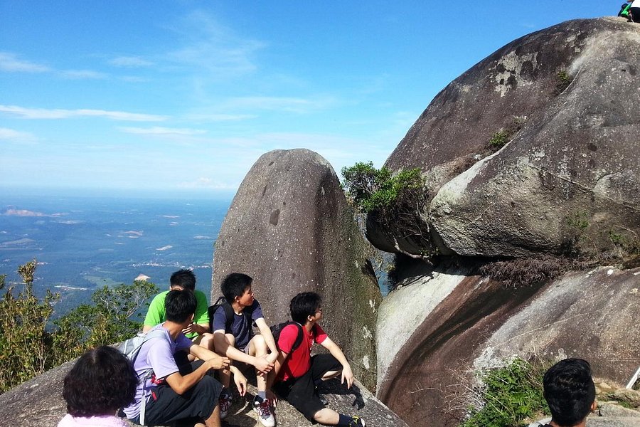
There are two walls of boulders to clear before reaching the summit of Gunung Datuk. For the first wall of boulders, there is a metal. A 2-storeys high wall of boulder is the final obstacle before the summit. As a safety precaution, hold onto the ladder at all times and be careful with the footwork. There are no large trees or thick vegetations to obstruct the view, making the Strait of Malacca visible from the summit on a clear day. The breeze and the scenery make the summit an ideal place for picnic and phototaking.
At the foot of the boulders that lead up to the summit is a wide clearing. This clearing can hold 5/6 tents comfortably, making it suitable as campsite. The campsite can get crowded if there are a few group of hikers staying overnight. There is no water source on Gunung Datok so carry sufficient water for your camping needs.
Climbing Fee – RM5.00 per pax
Parking Fee – RM2.00
Camping Fee – RM3.00 per tent
Tampin Hospital: 06-4411511
Tampin Police: 06-4411221/222
Ranger- in- charged Mr Zunaiddin Bujang
Rembau District Office Tel: 06- 6851225 ( Office)
Toilet and bathroom – Available.
Share My Hikes is a hiking destination guide which allow fellow hikers to freely edit, update and contribute contents to it.
We rely on the community effort to keep the guide updated . Find out more about the guide's aspiration at our FAQ page.
We Hike, We Share, We Make Friends:
If you interested to go here, we would love to provide guide service. Contact us at 016-2525848 (Amri)
Hey, good basic information!
I have a post on the trek, registration etc. The registration cost is still the same!
You can see here: http://www.yonderingsoles.com/2018/08/03/gunung-datuk/
Comments are closed.
- Philippines
- Itineraries

Climbing Gunung Datuk in Negeri Sembilan, Malaysia
Climbing Gunung Datuk takes roughly 4h30 (including 20 to 30min at the top). The mountain sits at 1,200m above sea level in Negeri Sembilan and is about 1h30 drive from Kuala Lumpur and can be done in a day.
This hike is a great training for climbing Mt Kinabalu as it’s steep and helps build stamina.
There is a car park by the entrance of the trail - you can also park along the roadside leading to the parking if it’s full. You will quite quickly see others doing it as you drive along the dead-end street leading to it.
You do not require a permit to attempt this hike. However, there is a checkpoint at the entrance of the trail where you will have to register and pay RM5 for Malaysians, and since November 2022, RM20 for non-citizens. (*Rant on*: they refused work permit for expats and we were charged RM20 too - they do not control ID ... so it's more the case of a "white men" tax. We climbed this summit paying RM5 many times, so it was quite infuriating. No improvements were made to facilities or trail. *Rant off*). It’s also because the trail entrance is closing at 12h. They don’t allow hikers after that. All climbers are expected to be out no later than 5pm.

The top is first a flat rock section and the peak boulder can be reached by a series of ladders. It’s a very nice place to find a spot and have breakfast. The summit sits in the clouds and the view can be disappointing on a cloudy day. We were told the clouds usually lift at about 11am. And we hiked it another clear day a few months later, and indeed the view is stunning!
It’s a beautiful hike, it’s long only because it’s steep and slow, but in terms of kilometers the trail is very reasonable, barely 6.8km return. It’s a great outing day with friends that could be combined with waterfalls nearby or booking a nearby guesthouse for a barbecue and stay the week end. We combined it with once a week-end in Melacca ( you already drove half the way afterall ) and once with Port Dickson.
You can also download the .GPX file to be imported into Google Maps or your Garmin watch as a Course .
This way you can save the path offline and use it during your walk.
Happy Trekking !

- Events Calendar 2024
- PR Newswire
- Johor Attractions
- Kedah Attractions
- Kelantan Attractions
- Top KL Attractions
- Labuan Attractions
- Langkawi Attractions
- Melaka Attractions
- Negeri Sembilan
- Pahang Attractions
- Penang Attractions
- Perak Attractions
- Perlis Attractions
- Putrajaya Attractions
- Sabah Attractions
- Sarawak Attractions
- Selangor Attractions
- Best of Terengganu
- Kids' Attractions
- City Walking Trails
- Hiking Trails
- Malaysia Mountains
- National Parks
- Beaches & Islands
- Hill Resorts
- Malaysian Wildlife
- Malaysian Museums
- MM2H Programme
- Malaysian Churches
- Malaysian Mosques
- Chinese Temples
- Hindu Temples
- Sikh Temples
- Thai Temples
- Historic Schools
- Clock Towers
- Lighthouses
- KL Nightlife
- Malaysia Trivia
- Philippines
- Gunung Datuk

Climbing Gunung Datuk is well worth the effort. It is quite a strenuous physical effort (at least for a middle-aged guy like me!) but at the top, once the path emerges from the thick jungle, hikers are rewarded with excellent views and a cooling breeze.
This mountain (Mount Datuk) goes by many names and spellings. On road signs it is sometimes spelt Gunung Dato' or Datok. Some maps show it as Gunung Rembau or Gunung Datuk Rembau.
The information board at the start of the trail explains the background to the name Datuk . It seems the mountain was named after Dato' Perpatih Nan Sebatang who in 1372 organized a gathering of leaders here to elect the future Dato' Lembaga (clan chief).
Datuks in those days must have been a fit bunch of guys!

Gunung Datuk is 884m high (2900ft), making it slightly higher than nearby Gunung Angsi which is around 22km away. On my list of Malaysia's Highest 300 Mountains Datuk comes in at number 220 meaning that it is a relatively minor peak but the highest one in Negeri Sembilan state on my list.
The starting point of the climb is probably less than 80m above sea level meaning that the actual height climbed is a solid 800m or so.
The distance covered is 4.6km each way as the bird flies meaning that the actual distance covered is probably considerably longer (sorry I did not measure it!).
It normally takes about 2 hours to reach the top and somewhat less coming down.

The path is pretty well defined all the way except at the very beginning. My sons and I managed to miss the start of the trail and spent half an hour floundering about in the jungle before we returned to the proper starting point.
Strips of red and white or yellow plastic tape are tied round branches periodically to let you know you are on the right track.
From the car park you descend a path to a stream, cross the bridge and find the correct trail (this is where we were initially lost).
The trail starts to climb immediately and the first hour or so is a fairly brutal ascent over twisted tree roots, rocks and dirt.

You will pass a wrecked gazebo with only the roof remaining intact. It appeared that the legs have been eaten away by termites and we saw a huge termite mound not far away.
We could hear apes whooping away and occasionally glimpsed them high in the tree tops.
Down at feet level were various insects, including a giant red Malaysian centipede (about 6 inches long and very fast moving) and what looked like monster wood-lice which rolled into a ball when disturbed.
We did not encounter any leeches but there has been a prolonged dry season this year. There are probably some after rain.

There were plenty of unusual looking mushrooms and fungus growth feasting on rotting trees.
After a while the path becomes slightly less steep and you might feel a refreshing breeze which is a welcome relief from the draining humidity. (Bring plenty of water/drinks with you. We had 1.5 liters each and it was only just enough.)
Eventually (it seems longer than 2 hours) you arrive at an open area beneath the summit which is presumably used as a campsite.

From here a number of steel ladders enable you to climb up the massive boulders which dominate the peak of the mountain. The ladders look a bit unsafe but they were not as scary as I feared.
On the summit you can rest on the flat boulders, enjoy the magnificent views and feel the cooling breeze. You are supposed to be able to see the Straits of Malacca on a clear day but it was partly hazy on our visit.
Look out for a footstep-shaped impression in one of the boulders which is said to have been made by the legendary Malaysian hero, Hang Tuah .
Coming back down is easier on the heart but hard work for the knees and leg muscles.
We enjoyed the hike which was short but strenuous. If you are wondering which to climb, Gunung Angsi or Gunung Datuk, I would recommend Datuk for its superior views.

How to Get to Gunung Datuk
If you are coming from Kuala Lumpur, exit the North-South Expressway at Exit 223.
At the T-junction after the toll, turn left.
You will reach a round-about where you should turn right (3 o'clock exit) sign posted towards Rembau. From Rembau town you will see signposts directing you to Hutan Lipur Gunung Datuk (or Dato') which will take you along route N111. After 15km or so you will see a turning to the left pointing to Gunung Datuk. After a short drive through a rubber estate you will arrive at the Gunung Datuk base camp where you can park your car.
You need to register at the office and pay fees.
Facilities and Fees
The friendly guy at the office told us that we were the only climbers that day (a Wednesday) but that it gets busy at weekends. I try not to be the first person of the day on the trail because of the spider webs (see my Mountain Climbing Tips) but there was no other choice that day.
The office and the park is open from 7am to 6pm.
Fees are as follows:
Climbing Fee RM5 per person
Camping Fee RM 3 per tent
Tent Hire (holds 4 people) RM5 per tent
The flat space just below the summit looked quite good for camping although there are no facilities apart from a very rustic toilet. I noticed that someone had sprinkled yellow rat or snake poison around the circumference of the camp site so perhaps there is a rodent or serpent problem at night. If campers would take their rubbish back down with them rather than trying to burn it the problem might be improved.
Climbing Guide:
-less than 20 people RM60
-25-50 people RM120
-more than 50 people RM180
It is not necessary to employ a guide and we were not offered one.
Chalet Rental RM50 per night or RM30 for a half day.
Rubber Tapping RM2 per person.
If you want to call the office (Koperasi Gunung Datuk Rembau Berhad) their number is 606-4381046 and email: [email protected]
Enquiries can also be directed to the Negeri Sembilan Forestry Department in Seremban on tel 606-6014000.
Forestry Dept website: www.forestry.gov.my
Share this page:
Like this website? Head over to my Facebook page and leave a like or comment:
You can also contact me via the link at the bottom of this page.

Recent Articles
Wonderfood Museum Penang - Plastic Has Never Looked So Tasty!
Mar 29, 24 12:36 PM

Wind Cave Nature Reserve, Bau, Sarawak
Mar 29, 24 12:12 PM

Malaysian Vehicle Registration Plates
Mar 29, 24 07:22 AM

More Recent Articles Here
Getting Around
- Free KL City Bus
- KL Hop-On Hop-Off
- BRT Sunway Line
- Malaysia By Coach
- Malaysia By Train
- Pangkor Ferry
- Marina Island Ferry
- Penang to Langkawi Ferry
- Visa Requirements
- Pet Friendly Hotels
- Majestic Hotel KL
- Hotels in Melaka
- Hotels in Penang
- Hotels in Putrajaya
- Port Dickson Resorts
CONTACT ME | PRIVACY POLICY | TRAVEL BLOG | ABOUT ME
Over 11 Million Unique Visitors Served Since 2011. Over 28 Million Page Visits. Statistics up to end March 2024.
Gunung Datuk
Top ways to experience nearby attractions
Most Recent: Reviews ordered by most recent publish date in descending order.
Detailed Reviews: Reviews ordered by recency and descriptiveness of user-identified themes such as waiting time, length of visit, general tips, and location information.

GUNUNG DATUK: All You Need to Know BEFORE You Go (with Photos)
A summit with a 360 degrees view of the surrounding landscape, a rewarding sight at the end of a short and intensive trek. Gunung Datuk is located in Kumpung Batang Nyamor, Gadung, about 21km from Rembau Town and 15km from Tampin Town, in the state of Negri Sembilan. A small mountain that stands near the end of Peninsula Malaysia main range (Titwangsa range), at the west of the mountain is the flat plains that goes to the Straits of Malacca and the Titiwangsa range flanking the other directions. The summit of the mountain was once used by Dato Perpateh Nan Sebatang to gather Ketua-ketua Adat (Customs Leaders) to announce the future Dao Lembaga (clan chief) in 1372 4 . The distance to the summit is relatively short and a fit individual can easily reach the top in about an hour. The huge rocks forming the summit presents an exciting challenge at the end of the forest trek.
The starting point of the trek is at Hutan Lipur Gunung Datuk or recreational forest Gunung Datuk where there is a registration counter and toilet facilities. Some temporary local food stalls may be set up at the car park during the weekends to cater for the visitors to the hill. A flight of stairs that goes down to a stream marks the start of the trail. There is a small dam that runs across the stream which you can walk on to get across without getting wet. A short walk along relatively undulating terrain brings you to a steeper ground. The steep ascent seems endless and can be physically taxing. However, after about half an hour to an hour of trekking, the terrain gives way to gentler section that will bring you to the false summit. There is a broken down small hut and a clearing where some big rock walls stands. This clearing is large enough for about four tents and it is suitable for camping. However, water needs to be brought up from the base of the hill. The true summit is at the top of the rock walls. There are some ropes and ladders to help you get to the top. If there are many visitors, you may have to wait for your turns to get to the summit. Some trekkers choose to start the trek before sunrise 1 to avoid the crowd and to catch the sunrise from the summit.
Very few mountain summits in Peninsula Malaysia can match that of Gunung Datuk. Devoid of vegetation, the Straits of Malacca can be seen on a clear day 2 . There is an imprint on the rock at the summit that looks like a footprint 3 . According to myth, the footprint is made by legendary warrior Hang Tuah who moves from place to place by jumping on mountains 4 .
- Take North South Highway (either from 2nd link or Causeway) in the direction of Seremban and KL.
- Drive all the way. You will pass exits for Muar, Ayer Hitam, Yong Peng, Muar, Segamat and Ayer Keroh. Your desired exit is the Tampin Exit.
- At the Tampin exit, after exiting the toll booth and making your (presumably) second contribution to Malaysian GDP, you should reach a roundabout. The 9 o'clock junction should be toward A'Famosa/Malacca/Ayer Keroh. I can't remember precisely. Do not take this exit. Take the 3 o'clock junction. This should be toward Tampin.
- After about 10 or 15 min, you will reach a T-Junction. You have now arrived at the old Trunk Road from Johore to KL, aka Highway 1. Take the left turn. This is toward Seremban/Senawang/Rembau. Do not take the right turn, which is toward Tampin. You're now heading approximately northwards.
- Travelling on highway 1 toward Rembau, within 10 or 15 min, or even earlier, you will reach a T-Junction without traffic lights. There will be a sign indicating that this is the turning for Gunung Datuk. Take this right turning off the highway. Should you overshoot, you will also see this sign going southwards after u've turned back. This T-junction is crucial. You must not reach any small towns or villages. If you do, you'll definitely have overshot. I believe the first village you hit if you overshoot should be Pedas. Look out for a sign mentioning Gunung Datuk.
- Okay, this part is a bit more difficult. After taking this right turn, you'll find yourself on a small country road. You should pass a muslim cemetery on your left. (if I recall correct). By this time you would have seen a mountain range to your front and left. Datuk is part of this range. After about 15-20 min you will see another sign (again saying gunung datuk) directing you left into a rubber estate. This small turn-off used to be opposite a small bus stop. This sign is crucial if you've no-one with you who's been there before.
- You're now on a small rubber plantation road. If u meet a car, either will have to pull to the side to make way. The plantation should remind you of the blair witch project! Hahaha. After about 10-15 min you'll reach the Base of Gunung Datuk. This will be preceeded by a small clearing which is kind of a broad clearing in the forests running in a long line. Immediately after the clearing is a rather steep incline which will flatten out into a parking area. Parking area has a stone and signboard in the centre.
- You have reached the foot of Gunung Datuk. Sign in at ranger station and have fun. Enjoy the view from the top!
- Light weight clothes
- First Aid Kit
- Extra clothing
- Swiss Knife
- Insect repellent
- Sufficient water (about 2L) for the trek
- Travelled Paths - Gunung Datuk
- Gaia Adventures - The Gunung Datuk Hike
- Dexxy.net - Gunung Datuk - A Legendary Mountain
- Wikitravel - Mount Datuk
- The Mountain Trekker - Gunung Datuk
- Malaysia Traveller - Gunung Datuk
- SG Adventures
- Scenic Treks
- Peak Climbing
- Seven Summits
- Start Trekking
- Twin Peaks Challenge
- Ice and Snow Challenge
- Women on Mountains
- Schools & Corporate
- South Korea
- South America
- Resource Centre
Malaysia – Gunung Datuk
Adding item to wishlist requires an account, already a member.
Username or E-mail
Forget Password?
Don't have an account? Create one.
- Duration: 1 Day
- Grading: 1A
Gunung Datuk (885m) is located in Gunung Datuk Recreational Forest , near Rembau town in Negeri Sembilan, Malaysia. While a relatively minor peak in Malaysia, it is the highest in Negeri Sembilan. The short trek makes it a popular mountain for day-trippers. The trail up is not too difficult but can be strenuous for some, and a round trip to the rocky summit and back takes about 4 to 5 hours. It has a unique and interesting summit made of huge boulders. There are metal stairs in place at the bottom of the boulders to enable trekkers to get to the top. For those afraid of heights, the last portion might seem to be a little challenging. The awesome view of the surroundings from the summit rocks is well worth the effort.
Gunung Datuk, though much higher than Gunung Lambak or Gunung Arong , is still a good introduction to tropical jungle mountain trek for beginners. Like most small mountains in Malaysia, the steep and natural trail up to the summit provides a good challenge on footwork and for first-time trekkers. It is also an excellent vigorous workout.
A trekking permit is required to trek Gunung Datuk. There is a Forest Ranger station at the foothill to apply and pay for the permit fee.
About The Climb
Negeri Sembilan is about a 3 to 4 hours drive from Singapore. It is possible to drive from Singapore overnight or in the morning to Negeri Sembilan to climb Gunung Datuk and make it back to Singapore on the same day.
Our Gunung Datuk trek is a sunrise trek, with a midnight drive from Singapore to Negri Sembilan. The expected arrival time at the foothill is 4am, and heads off immediately to the peak to try to catch the sunrise.
The trek will be done in pitch darkness hence a headlamp is a must. The well-defined trail is an incline uphill all the way to the summit. Similar to most of the tropical jungle mountain treks in Malaysia, the sloping terrain is covered in undergrowth and thick protruding roots. However, a clear and well-used trail makes the trek straightforward. It takes about 2 to 3 hours to reach the huge boulders that lead to the peak. Two sets of metal stairs are built for trekkers to get to the top of the boulders. Take a break and have a snack while enjoying the sight of the sun rising up from the horizon and the 360 degrees view of the surrounding landscape. On a clear day, you can actually spot the Straits of Malacca. Also, look out for a footstep-shaped impression in one of the boulders which are said to have been made by the legendary Malaysian hero, Hang Tuah.
The descent is another 1.5 to 2 hours same way back, in daylight, to the foothill. There are toilet facilities for a quick wash up & change of clothing at the foothill. We will do a stop-over for a late lunch in a nearby town before heading back to Singapore.
Trekking Seasons
The best time to climb Gunung Datuk, or any of the mountains in West Malaysia, is from March to October, outside the monsoon season . Chances of encountering bad weather and rain can be high from December to early February.
Experience Required
This trek is graded 1A.
Trekking experience is not required. Anyone with a reasonable level of fitness can complete this tropical jungle mountain trek and have an enjoyable time. You will be trekking for 5 to 6hrs with a 3-4kg day pack on mostly vertical tropical rainforest terrain partly in the dark till sunrise. The last section of the trek to the summit is on a flight of metal steps.
Equipment and Gear
You can wear a quick-dry t-shirt, sports shorts/tights or trekking pants, and trail shoes. Bring a headlamp, and rain gear, and waterproof your backpack.
- Goup size: 20 – 35 people
- Chartered air-conditioned passenger van or coach
- Trek leader(s) – 1st aid responder + experienced with good track records in leading Malaysia treks
- Trekking permit
- Safety management and first aid support
- Trip information kit
- Travel insurance (can be deducted if you have your own)
- Visa (if any)
- Drinking water and beverages
- Personal expenses – shower fee, drinks and snacks, etc.
- Personal hiking & travel gear
- Compensation for damaged or lost of personal items (eg. climbing/trekking gear and equipment, cameras and any valuable items, etc.)
- Emergency evacuation and medical expenses
- Any expenses including accommodation, meals & transfer outside the stipulated trek/climb itinerary – i.e. any person leaving the group for personal travel, illness/injury or any form of extension of stay
No visa is required for a stay of less than one month for nationals of all ASEAN countries except Myanmar. For a stay exceeding one month a visa will be required, except for nationals from Brunei and Singapore.
Nationals or passport holders of the following countries require a visa to enter Malaysia.
* Entry by air only
For latest updates and details of visa application, please visit https://www.malaysia.gov.my/portal/subcategory/1543.
In Malaysia, there are moneychangers located at the airport terminals, in shopping malls and shops in the city centres, as well as major rest stops along the North-South Highway in Peninsula Malaysia. You can also change money at the banks and hotels. The rates at the moneychangers tend to be better than those offered in the hotels and banks. It is best to change money in the city, prior to travelling to the National Parks or remote areas where there is likely no moneychanger or bank; or the exchange rates offered by the hotels tend to be high. Double count your money before leaving the moneychangers to make sure the accurate amount is given.
Credit cards, such as Visa and Mastercard, are readily accepted by hotels, major stores and restaurants in the cities and the major tourist areas. The smaller and local establishments typically accept only cash payment. ATMs are widespread in the city and some town areas and accept the common network such as Visa, Mastercard, Plus, Cirrus, etc.
Malaysian Tourism Tax (TTx)
Effective from 1 September 2017, foreign tourists staying at paid accommodation in Malaysia are subject to pay a Tourism Tax of RM10 per room per night. This flat rate of RM10 will be applicable for all room types, based on per room per night. Collection of this tax will be payable to the hotel/lodge directly. Under the Tourism Tax (Exemption) Order 2017, Malaysians or Permanent Residents with MyPR cards are exempted. The TTx is mandatory and regulated by the Ministry of Finance and the Royal Malaysian Customs Department.
Electricity
Malaysia’s electricity is 240 Volt and 50 MHZ. The electric plug is the rectangular blade plug or Type G, used in the UK.
The official language in Malaysia is Bahasa Melayu, although many Malaysians speak several languages and will use them all in general conversation. English is a compulsory subject in all schools and is widely understood, especially those working in the tourist industry like the tourist guides and hotel staff.
Drinking Water
It is strictly not recommended to drink water straight from the tap. You should boil the water before you drink it or buy bottled water. Bottles of mineral water can be easily purchased in hotels, restaurants, supermarkets and petrol kiosks in Malaysia. Many hotels also provide a small bottle of complimentary mineral water per day to each guest.
Giving a tip to tour guides is a common practice in Malaysia but other service staff in hotels, restaurants and taxi drivers in general do not expect a tip from tourists. Service charge of 10% is included in hotels and most restaurants.
Travel Safety Advice
With evolving world situations that may occur unexpectedly due to natural disasters, pandemics/epidemics, conflicts and unrests, it is best to read up and keep tabs on news and developments at your destination country and region before the trip. Check on the country’s official website and/or your own foreign ministry website for any travel advisory or safety precautions to be taken while abroad.
As with traveling in anywhere in the world, regardless of the local crime rate, stay vigilant and take care of personal safety. Good to read up on any possible exposure in the country prior to departure.
It is a good practice to register with your respective foreign ministry if there is such a service provided to citizens, to contact you in order to make sure that you are safe and, if need be, assist you should an emergency (e.g. natural disasters, civil unrest, etc.) occur when you are overseas.
For Singaporeans, this is the link to the Ministry of Foreign Affairs’ eRegister: https://eregister.mfa.gov.sg/eregisterportal/common/preLoginEregisterView.action .
Travel Insurance
It is highly recommended to purchase comprehensive travel insurance(s), upon payment of your trip, to cover adverse situations that may occur while you are overseas or even before departure. Ensure that the coverage is suitable for your destination and the activities that you are participating in. Be familiar with the terms and conditions before purchasing and travelling abroad.
Travel Immunization Advice
There is no compulsory vaccine to be taken to enter Malaysia. You should, however, be up to date on routine vaccinations, especially vaccines against water-borne, food-borne, parasitic and other infectious diseases (examples: hepatitis, typhoid and tuberculosis) while traveling to any destination. You are encouraged to consider having vaccinations before you travel. At least eight weeks before you depart, make an appointment with your doctor or travel clinic for a basic health check-up, and to discuss your travel plans and any implications for your health, particularly if you have an existing medical condition.
Recommended routine vaccinations for travellers in general:
For more information and professional advice on travel vaccinations, please consult your doctor or travel clinic.
For people residing in Singapore, you may visit The Travellers’ Health and Vaccination Clinic (THVC) at Tan Tock Seng Hospital:
Travellers’ Health & Vaccination Clinic Address: Level 4, Clinic 4B, Tan Tock Seng Hospital Medical Centre Contact number: 6357 2222 Website : https://www.ttsh.com.sg/Patients-and-Visitors/Medical-Services/Travellers-Health-and-Vaccination-Clinic/Pages/default.aspx .
General Health Advice for Malaysia
Malaysia’s climate is equatorial and tropical, meaning it is generally hot and sunny all year round. Mosquito & insect bites and sunburn are typical health concerns in such a tropical place, particularly for those who stay outdoors for long hours.
Mosquito and insect bites are common in the lowland areas in Malaysia, especially in the jungle. Apart from acting as carriers of disease, mosquito & insect bites can result in unpleasant and occasionally serious skin reactions. You are advised to take measures to avoid mosquito and insect bites, including using an insect repellent at all times and wearing long, loose fitting, light coloured clothing in the evenings. Some simple ways to minimisation of exposure to mosquitoes:
- Avoid dark coloured clothing as it attracts mosquitoes as do perfume, cologne & after-shave.
- Clothing to cover arms and legs in the evenings. It is common for mosquitoes to attack leg/ankle region.
- Apply mosquito / insect repellents diligently.
Other Adventures
Vietnam – Mt Fansipan
Duration: 5 Days Grading: 2B
Bhutan – Bumthang and Bumdra Treks with Domkhar Festival
Duration: 11 Days Grading: 1B+
- Login or Create an account
Gunung Datuk Recreational Forest

Introduction
Gunung Datuk Recreational Forest (Hutan Lipur Gunung Datuk) is an iconic mountain in Rembau district of Negeri Sembilan, that is 884m high (2900ft). It’s a popular one-day hiking destination, with an amazing unobstructed 360-degree view of the Straits of Melaka at the summit.

What to Expect?

Look Around

Address: 71350, Kota, Negeri Sembilan

Aisyah Mardhiah
A great dayhike. Quite challenging for beginners. Took around 1h30 mins to reach the peak. Depends on your pace. The view is magnificently beautiful. Permit : RM5

Very nice view, 360 view. The coming down takes alot of time, need to go slow as very steep. Better bring good hiking stick

Aarogya Banepali
There's a registration fee (RM 20 for foreigners) but the view and hiking experience is worth the price. Met amazing people along the way and overall had a great time. There's also a friendly squirrel roaming around the top! Both climb and descent can be a bit steep and slippery if it has been a rainy week, so be careful on your way.

Great hike but definitely challenging. Well marked with ropes to help with verticals. Make sure to go until the top and it's really worthy to see a great view. Make sure bring enough water to stay hydrated.

An intermediate hike. Took about 2.5 hours to reach the peak with multiple stops that include taking photos. Spent half an hour at the peak to enjoy the magnificent views but it was really windy up there. So, it’s advisable to bring a windbreaker. However, we only took an hour to descend as my Garmin was running out of battery. Things to bring: Torchlight if you are climbing very early in the morning Windbreaker Hiking shoes Water (at least 1.5 L) Food just in case you are hungry Rm5 for the entrance fees Summary of the climb: Overall time: 3:56 hours Distance: 6.92 km Total Ascent: 598 m

Similar Places

Pantai Cahaya Negeri Beach

La Hot Spring

Pantai Tengah Beach

Black Sand Beach

Jeriau Waterfall

Tempurung Cave

Pantai Remis Beach Shore

Chamang Waterfall
- Login Sign Up
- Gunung Datuk Sunrise Hike-27Aug2022
- Gunung Datuk
Mount Datuk is one of a favorite place for nature lovers and adventure seekers to capture a sunrise over such a short hike. It holds many treasures of the natural tropical rainforest. As you can see in the picture, there’s a formation of big rocks at the summit.
The trail is not so tough that from Intake/Starting Point, it takes about 2-3 hours for a non-hiker to reach the summit. Regular hiker that is fit enough easily can make it in 1hour 30mins to the summit. Some part of the trail section is steep but it can easily climbed over a slow walk up.
Event Highlights:
• Magnificent view of sunrise at Gunung Datuk • Great view of the Strait of Malacca • Jonker Street • Baba Nyonya Heritage • Try out some delicious food @ Jonker Street – Kedai Kopi Chung Wah: Chicken Rice Ball -Nyonya Chang (Nyonya Rice Dumpling) -Durian Cottage: Durian Bomb -Aunty Koh: Gula Melaka Cendol -Candied Fruit
- All participants for the this tour need to be vaccinated.
- Do check you have a valid passport/Expiry date for the event, as passport copy will be needed to apply permits.
- Advised to get travel insurance once you book the event.
EVENT DATE: 27 Aug 2022
Event duration: 1day trip, event cost: .
SGTREK MEMBERS: SGD125/Pax
NON-MEMBERS: SGD135/Pax
Become a SGTREK Member and enjoy the benefits. Read here for Membership benefits: https://sgtrek.com/sgtrek-membership/
*All the parks in Malaysia have a new guiding rules. Guide ration 1Guide:7clients. Cost of the permits and guiding fees have been increased since pandemic.
- Group size below 15pax – Transportation is Van
- Group size above 25pax – Transportation is Coach
STAFF CONTACT: +6592700908 (WhatsApp)
Duration : 1 Day Trip
Meetup Place : Marsiling MRT BUS STOP (*Near to maxicash)
Meetup Time : 11:00pm (on 26-Aug-2022)
Gunung Datuk located at Rembau, Negeri Sembilan, Malaysia.
- Altitude : 870m /2900ft
- Location : Negeri Sembilan, Malaysia
- Usually it takes 4 to 5 hours
- Good for Training. You’ll need to have at least some stamina/ hiking experience, else you’ll be crazy tired. ( Moderately Challenging )
Hike Grading : Moderate https://sgtrek.com/hike-grading/
ITINERARY HIGHLIGHTS:
- 11:00pm (on 26-Aug-2022) sharp meetup at the Marsiling Bus Stop, quick briefing and we will depart once the transport arrives
- We shall not be waiting for any late comers, so do plan your way to be early at the meetup location
- Depart to SG Customs and then to JB Customs
- At JB customs there are shops you could buy snacks for the trail, water etc. (You can also prepare to bring some food from the house for breakfast before to the hike and some trail food)
- Drive to Gunung Datuk
- Along the way we will have a short break at the R&R (You can pack some breakfast or food here for the trail, take atleast 1.5l water for the trail)
- 04:00am Arrive around Gunung Datuk
- All your unwanted things can leave in the transport and only take things needed for the hike
- Headlamp is compulsory do not bring torch lights as along the hike you may need to grab ropes, roots etc. keeps hand free while hiking
- SGTREK Leader will do a quick safety briefing and then start to hike
- Once you arrive at the start of the trail there is basic toilet facilities for you to use
Start to hike below is the rough guide:
- Usually a fit climber can reach the summit in 1.5hours from the base, average a person can take up to 3 hours. Do take note this is a beginners walk so go up slowly
- Mixed trail with a bit of steep climb some parts (Need to grab roots, ropes)
- Arrive at summit and wait for sunrise (There are Ladders to climb before summit) – No taking of pictures at the cliff edges
- 08:00am start to descend down from summit after Sunrise
- Descent to base
- Once everyone arrives, you could use the shower facility and change your clothes
- From here we will drive to Melaka (Take around 1hours depending on the traffic)
- After arriving at Melaka free and easy (You can enjoy the food, massage, shopping etc.)
- Around 4pm-5pm Depart from Melaka back to Singapore
- 11:00pm arrive in Singapore ETA.
*itinerary may vary along the way accordingly to the weather condition on the day.
Trip Includes:
- SGTREK LEADERS
- Park Entrance/ Permit fees
- 2way Transport from Singapore
Trip Excludes:
- Travel Insurance
- Tips for local guides/Driver
- Any other personal expenses
- Covid19 Tests (Pre/Post)
- Food other than specified in itinerary
Please note the following items to bring on our own :
- Day Backpack hike (Make sure light backpack)
- Gloves/Knee pads/Hiking Poles
- Water Proof bags for Rain shelter
- Long-sleeved T-shirt and long track bottom / Change of clothes
- Personal medication if any
- Raincoat or windbreaker
- 1 pair good shoe for hiking
- 1 sandal/slipper
- 1 headlamp / Torchlight (*Not allowed to hike without headlamp)
- Insurance is a must to have for adventure sports
- Energy bars/light snacks.
By Joining this trip, YOU:
- Acknowledge all the TERMS & CONDITIONS: https://sgtrek.com/terms-conditions/
- Acknowledge that YOU have read and agreed to RELEASE OF LIABILITY, WAIVER OF CLAIMS, EXPRESS ASSUMPTION OF RISK AND INDEMNITY AGREEMENT FORM of (SGTREK) : https://sgtrek.com/sgtrek-indemnity-form/
- YOU have read all the above paragraphs and YOU know, understand, and appreciate these and other risks that are inherent in The Activity. YOU hereby assert that your participation is voluntary and that YOU knowingly assume all such risks.
- YOU acknowledge the agreement freely and voluntarily, and intend by completing this form and unconditional release of all liability to SGTREK PTE. LTD.
TERMS & CONDITIONS: https://sgtrek.com/terms-conditions/
For any queries related to the event do contact below person: Phone: +65 92700908 (WhatsApp) Email : [email protected]
This trip is organized by: SGTREK PTE. LTD . Reg. No. 201816267K STB License No. 03160
Address: 28A, Kandahar Street Singapore 198889 Email: [email protected] WhatsApp: +6592700908 Website: https://sgtrek.com
- Ticket & Prices
- Related Events
- Start Date August 26, 2022 23:00
- End Date August 27, 2022 23:00
- Remaining Ticket: 0
- Status Expired
- Location Gunung Datuk
- Venue Malaysia
- Hem (Crazy Mountain Boy)
- Address Gunung Datuk
- Event Expired
- Datuk Sunrise
- Gunung Datuk Sunrise
- Gunung Datuk Sunrise Hike
View Cart Checkout
IMAGES
VIDEO
COMMENTS
Itinerary for Day trek to Gunung Datuk. Night 1: 2330 Meet at assigned meeting point and depart by ac van (10 seaters) Day 1: 0600 Arrive base, rest and breakfast. 0700 Start hike. 1000 Arrive summit with great views of Malacca Straits if sky is clear and rest. ... Entrance fees : Gunung Datuk;
first attempt to Gunung Datuk. Feb 2020. Visited gunung datuk last weekend 2nd Feb 2020. There are ample parking space and toilet at base. bring along headlamp, enough water, energy gel, food etc. The park ranger counter will open around 6:30AM on weekend and you will be charge RM5 per person. For myself start hiking at 4:20 AM and reach the ...
Gunung Datuk is located in the state of Negeri Sembilan, near to the town of Rembau. 1. Is Gunung Datuk worth trekking? ... I keep reading reviews that say this is an easy trek and good for beginners,from my point of view this is misleading.I have tried ayer hitam forest reserve at puchong wawasan and thats considered a beginners trail at 7km loop.
Gunung Datuk is located at GPS coordinates N2.55110 E102.18271. By Train (KTM Komuter) Alight at Seremban and take a bus to Rembau from Terminal 1 Bus Station (a short walking distance from train station, after the Seremban Fire Station). Stop at Kota and walk for about 2.5 kilometers to reach the foot of the mountain.
Climbing Gunung Datuk takes roughly 4h30 (including 20 to 30min at the top). The mountain sits at 1,200m above sea level in Negeri Sembilan and is about 1h30 drive from Kuala Lumpur and can be done in a day. This hike is a great training for climbing Mt Kinabalu as it's steep and helps build stamina. There is a car park by the entrance of the ...
The Climb. Gunung Datuk is 884m high (2900ft), making it slightly higher than nearby Gunung Angsi which is around 22km away. On my list of Malaysia's Highest 300 Mountains Datuk comes in at number 220 meaning that it is a relatively minor peak but the highest one in Negeri Sembilan state on my list. The starting point of the climb is probably less than 80m above sea level meaning that the ...
Challenging trek with steep jungle trails. Jan 2016 • Friends. Gunung Datuk is 884m high that covered mostly of steep jungle trails. 4 of us took about 5 hours to complete this trekking journey. We started from the registration counter at 12.10pm and reached the summit at 3pm. We reached back at the starting spot at 5.20pm.
In my view, from the junction in Kg Bongek, we need other signboard showing Hutan Lipur Gunung Datuk. I really enjoyed the new stairs at the peak which its good and safety for people and kids. The trek can handle where some parts need to be extra careful. At the top, we can see a memorable view where sightseeing the Straits of Malacca.
Bathing facilities are available at 1RM, with fresh, cool water from the mountains, a perfect way to end your trek! There is a small shop selling food such as fried noodles and rice, along with water, of course at a slightly higher price than normal. ... We left Subang Jaya at 6.30am and reach the entrance at 8.30am at Hutan Lipur Gunung Datuk ...
The summit of Gunung Datuk which is made out of boulders with little vegetation, gives you a 360° view of the surrounding landscape. Gunung Datuk ... The starting point of the trek is at Hutan Lipur Gunung Datuk or recreational forest Gunung Datuk where there is a registration counter and toilet facilities. Some temporary local food stalls may ...
Malaysia - Gunung Datuk. Gunung Datuk (885m) is located in Gunung Datuk Recreational Forest, near Rembau town in Negeri Sembilan, Malaysia. While a relatively minor peak in Malaysia, it is the highest in Negeri Sembilan. The short trek makes it a popular mountain for day-trippers. The trail up is not too difficult but can be strenuous for ...
Mount Datuk (Malay: Gunung Datuk; Jawi: ڬونڠ داتق), also known as Mount Rembau, is a mountain situated on the border between Batang Nyamor, Rembau District and Johol, Kuala Pilah District in the Malaysian state of Negeri Sembilan, at the southern section of the Titiwangsa Mountains.At around 884 m (2,900 ft), it is the highest mountain in the district of Rembau.
Gunung Datuk Recreational Forest (Hutan Lipur Gunung Datuk) is an iconic mountain in Rembau district of Negeri Sembilan, that is 884m high (2900ft). It's a popular one-day hiking destination, with an amazing unobstructed 360-degree view of the Straits of Melaka at the summit. ... The Hike: The starting point of the trek is at the recreational ...
Trans Yam Tuan Antah (YTA) is situated in Negeri Sembilan, offering a thrilling hiking experience that encompasses trekking across three majestic summits: Gunung Datuk (855m), Gunung Rembau (884m), and Gunung Gagak (807m). The journey commences with a vibrant rainbow staircase leading up to Gunung Datuk, the initial summit.
Meetup Time : 11:00pm (on 26-Aug-2022) Gunung Datuk located at Rembau, Negeri Sembilan, Malaysia. Altitude : 870m /2900ft. Location : Negeri Sembilan, Malaysia. Usually it takes 4 to 5 hours. Good for Training. You'll need to have at least some stamina/ hiking experience, else you'll be crazy tired.