Tadiandamol Trek
Trek to the Highest peak in the Kodagu district

Good news for explorers! We now have our DIY kits available out of our Bangalore office.
This makes it super easy for you to explore treks around Karnataka. Start planning your adventure now. Fill out the form on this page to rent our DIY kits

The Complete Guide to Tadiandamol Trek
A very popular trek amongst the trekking community of Southern India. Tadiandamol Trek is one of the most talked-about treks between trekkers starting out to their trekking journey in the Western Ghats and even experienced trekkers. The trek also draws many visiting the famous hill town of Madikeri or Coorg.
The trek takes you to the highest peak of the Kodagu district and the third highest peak of Karnataka. Tadiandamol trek is a Western ghats trek which falls in the Brahmagiri Wildlife Sanctuary of the Bhagamandala Range Forest.
Trekking here will take you through a mix of thick shola forests with stream crossings, a carpet of beautiful grasslands. Added to this, the thrill of reaching the peak of Tadiandamol, trekking amidst the clouds is definitely something one must experience.
There is also an ancient palace used by the rulers of Coorg, at the base of the hill , which you can visit on your way back.
The trek will test your endurance, even if you are an experienced trekker. This trek can be done by fit beginners. However, go through the tips and detailed trek information to plan it out well.
Table of Content:
- What to watch out for
- Trail Information
- Best Season to do the Tadiandamol Trek
- How to reach
- Places to Visit Near Tadiandamol
➤ What to watch out for
1. view of the rolling green hills while climbing to the peak of tadiandamol.
Standing at a height of 5,735 feet, the view from the peak is stunning to witness. You can see the green hills spread across as far as the eyes can see. This extends in all directions from the peak.
The valleys are filled with the evergreen forests.

View of the green hills stretched across all directions. You can see the patches of the Shola forest in between. Picture by Akshay K
Often this view is difficult to get during the monsoon and post-monsoon season when clouds cover the entire region. To get clear views, go just before the start of the summer season
2. Trekking in the Splendid Evergreen Forests of Shola
The Shola forests are stunted tropical forests found in valleys amid rolling grassland in the higher mountain regions. The trek is a hotspot for various flora and fauna.
One can spot coffee estates and pepper plantations throughout this entire stretch of the trek. Along with these, you have the Arecanut (Betel nut) trees, Nutmeg trees, fishtail palms, and various other trees growing here.

Trekking through the forest section. Picture by Suhas Saya
If you are a keen observer while trekking through the forest, you will definitely spot various millipedes, Calotes Versicolor lizards , many species of butterflies and if you are lucky, maybe even spot a snake slithering on its way across the trail. You will definitely have the company of leeches if you are trekking in the monsoon or post-monsoon season.

Head of DIY and Documentation Team
"Even though the Tadiandamol trek is very popular and a nice trek to do, I have a bone to pick here while comparing it with other treks in the same region. If there was a choice given to me, I would any day select the Kopatty Trek which starts from the Cherambane village. The rewards on the Kopatty trek are marvelous. A lesser-known trek amongst trekkers. It is easily the underdog that has more things to offer. Tadiandamol Trek having the title of being the highest peak in the Coorg district, usually takes up more space in the trekking circle."
➤ Trail Information
Tadiandamol Trek can be divided into four sections. If you are taking your own vehicle or a jeep/auto from Kakkabe, you can exclude the first section until the Nalknad Palace. The next three sections will be valid for you.
- Walk on the road from Kakkabe Bridge to Nalknad Palace
- A gentle ascent from Nalknad Palace to the Base of Tadiandamol
- Trek from Base of Tadiandamol to the Boulder point
- Climb from Boulder point to the peak of Tadiandamol

Trail Map of Tadiandamol Trek. Source: Google Earth. Picture Courtesy Suhas Saya
Section I: Kakkebe Bridge to Nalknad Palace
Trek Distance: 5.54 km Trek Duration: 1 hour GPS coordinates of Kakkebe Bridge: 12°15'22.1"N 75°38'36.0"E GPS coordinates of Nalknad Palace: 12°14'07.7"N 75°38'23.7"E
Start your trek in the morning. If you have taken a local bus, it drops you at the Kakkabe bridge. If it's a bus going forward on the Virajpet-Talakaveri road, you have the option to get down at the junction of Aramane and Kakkabe saving 15 minutes of walk.
Otherwise, start your trek from the bridge, towards the Virajpet-Talakaveri road that continues to the East.

Starting the trek from the Kakkabe Bridge. Picture by Roshan Padhi
If you are unsure, just ask the locals around and they would point you in the right direction.
It takes about 15 minutes for you to reach the junction of Aramane and Kakkabe road head. You need to take the right which leads to the Nalknad Palace Road.
If you are not confident of your fitness and want to skip this first section, you have an option to do so. You won’t be missing out on much. Take an auto or hire a jeep from the bridge to Nalknad Palace. An Auto will cost you Rs 400 while a jeep costs Rs 750 to 800. You can also take a shared option if you see other trekkers starting from the bridge. It will save you one hour of walking through the 5.5 km road head to Nalknad Palace.

Junction of Aramane and Kakkabe Road. Notice the board saying the way to Nalkand Palace which is 3 km from here. Picture by Saurabh Sawant
From the junction, the road is straight forward until you reach the Nalknad Palace. A vehicle can easily go up until the Nalknad Palace. If you are using your own vehicle, you can skip to the next section or read more about how to reach and then come back.
Initially, you will come across a number of cottages and resorts/homestays on this road, around 5 to 6 of them. If you are planning to stay for a night here after the trek, you can book before going up on the trek.

Initial section through the greenery and estates. Picture by Saurabh Sawant
Keep your eyes and ears open while trekking here to spot various flora and fauna.
One can spot pepper and coffee plantations throughout this entire stretch of the trek. Along with these, you have the Arecanut (Betel nut) trees, Nutmeg trees, fishtail palms, and various other trees growing in the farmlands.
Trekking the early morning also adds to the chirping of birds.

The road to the left leads to Nalkand Palace. Skip this and continue ahead on the road. You can visit the palace on your way down. Picture by Suhas Saya
Zigzag roads and trekking for about 40 minutes to reach the Nalknad Palace . Visit this historical palace on your way down post trekking. You don't want to waste time exploring this on the way up.
Until early 2020, this was the last place where vehicles can go. Recently concrete blocks were being laid out until the base of Tadiandamol. If that gets done, the vehicles can go all the way up till the base.
Section 2: Nalknad Palace to Base of Tadiandamol
Trek Distance: 2 km Trek Duration: 55 minutes GPS coordinates of Nalknad Palace: 12°14'07.7"N 75°38'23.7"E GPS coordinates of Base of Tadiandamol: 12°13'54.9"N 75°37'48.9"E
The trek now takes a more gentle ascent through a mud and gravel section from the Nalknad Palace to the base of Tadiandamol, where the actual trekking trail starts from.
Do not miss the waterfall when you are about to start the trek from Nalknad Palace. If you are trekking in the monsoon or the post-monsoon season, watch out for this unknown waterfall just 5 minutes into the trek.

Waterfall near Nalkand Palace on the Tadiandamol Trek. Picture by Suhas Saya
We have marked this on the GPX file as well so that you don't miss this spot. So don't forget to download the file if you want to visit this hidden gem.

Coming out from the waterfall section to the main trail. Picture by Saurabh Sawant
Explore this section for a few minutes and head back on the main trail of the trek.
You will have a mix of broken tar road, muddy trail with small gravel, and concrete roads starting from here. The trek again takes you through green lush vegetation for about an hour.

Trail with gravel, broken tar road through lush vegetation. Picture by Saurabh Sawant
Half an hour into the trek, you find this last house where a small stream runs by the side of it. You can refill your water bottle here.

Last house before the base of Tadiandamol. Picture by Saurabh Sawant.
The base of the Tadiandamol is just 10 minutes away from this spot. Watch out for the viewpoint on the right to see the entire region opening up right in front of you.

Viewpoint from the base of Tadiandamol Trek. Picture by Suhas Saya
Section 3: Base of Tadiandamol to the Boulder point
Trek distance: 2.30 km Trek duration: 1 hour 20 minutes GPS coordinates for base of Tadiandamol: 12°13'54.9"n 75°37'48.9"e GPS coordinates for the boulder point: 12°13'33.2"n 75°36'51.4"e
At the base of the Tadiandamol trek, you see two trails. there is one going on the left and the other on the right. you have to take the trail ascending on the left here.

Take the left trail to the Tadiandamol Peak. Picture by Suhas Saya
Do not take the trail on the right which leads to a few farmlands and houses.
Notice a green board from the forest department which points to the left where the ascent starts. The board is slightly old and rusted. It points up marking 3.75 km left for the peak.
The trail from here onwards is a proper mud trail all the way.
About 15 minutes to your ascent, you will have your first stream crossing. We suggest you remove the shoes and socks to cross this stream. The shoes can get wet otherwise and ruin your trek later. Trekking in damp shoes or socks is no fun. The water will be more than your ankle. If you are trekking during the monsoon, it will be even higher.

First Stream Crossing on the Tadiandamol Trek. Trekking Poles help get balance while crossing the stream. Picture by Saurabh Sawant
Leeches start from this area and continue all the way until the grassland section on the trek. You have now entered the thick of the Shola forest.
| Tip: Apply Dettol or Savlon at the base of Tadiandamol to avoid leeches if you are scared of leeches. If you are not too worried, the best option is to remove once you reach the grassland or summit. A few leeches sucking some of your blood won't do any harm.
Close to 200 meters after the stream crossing, you have the forest check-post. Each individual has to pay Rs 50 to proceed further. The forest officer will check your bag for plastic items that you are carrying. Any liquor or unwanted things will not be allowed on the trek and will be confiscated. Do not carry them in your bag.

Forest Checkpost on the Tadiandamol Trek. Picture by Saurabh Sawant
After the entry is done with your name, contact numbers, you can proceed further on the trek.
Note: You cannot trek past the forest check-post after 2:30 pm
Keep your eyes to the right side when trekking. The view opens up suddenly. Often, the clouds cover up the entire valley to the right. If the sun is shining and you have a clear day, you see the valley in lush green and hills starting to pop out.

Views starting to open up. Picture by Suhas Saya
You will have a second stream crossing coming up soon. This stream crossing is smaller than your first one. Looking at the depth of the water, you can think of crossing either by removing your shoes or not.
Once you cross, try to spot a small milestone saying 2 km left for the peak on your right. It can be hidden by overgrowth as well. It's more like playing a game of spotting this stone.
Trek for another 20 more minutes to cross the forest section. The canopy of trees starts to fade out and you have now entered the grasslands.
Your next stop is about ten minutes away from the boulder point.

Big Rock Point on the Tadiandamol Trek. Picture by Suhas Saya
Take a small break and hydrate yourself. The last section of the trek to the peak is remaining which will be your maximum ascent.
Section 4: Boulder point to Peak of Tadiandamol
Trek distance: 1.68 km Trek duration: 1 hour 15 minutes GPS coordinates for the boulder point: 12°13'33.2"n 75°36'51.4"e GPS coordinates for the peak of Tadiandamol: 12°13'02.4"n 75°36'31.8"e
From the boulder point, you see a hillock. This is a false peak and not the actual peak of Tadiandamol. The peak of Tadiandamol is much further and towards the left or the southern side facing the false peak.
Begin your ascent following a well laid out trail in front of you. The majority of time, mist and clouds cover this last section.
Trekking through the mist and clouds is a beautiful experience. You will find orange ribbons tied on trees by the forest department which act as markers on the trail. If you spot this ribbon, you are going on the right trail.

Start noticing the Orange Ribbons placed as markers on the trail of Tandiandamol Trek. Picture by Suhas Saya
Around 20 minutes trekking with a moderate climb, you get to a point resembling a fort structure. Past that, follow the trail, and keep to your right.
There is one fork that can put a thought in your mind. Either look for the orange ribbon or keep to the trail on the right.

Take the trail to the right. Picture by Suhas Saya
There are a couple of viewpoints sections that you can take a couple of breaks to soak in the views. Spend a few minutes looking back at the green rolling hills as you climb up.
Take a few sips of water. You are now going to enter the second forest section from here.

Don't forget to look back every now and then while climbing up the slope. Picture by Suhas Saya
The trail here is much more slippery and uneven. Watch your footing and take the support of trees as you ascend for another 10 minutes through the forest.
| Tip: A trekking pole is extremely helpful. Carry two trek poles to help you on the trail. To know more about how to use a trekking pole, go through this video .

Second Forest Patch. Picture by Roshan Padhi
Once you cross this forest section, you are left with one final push to the peak of Tadiandamol. It takes about roughly 20 to 25 minutes to reach the top.
If you are trekking in a group and if the weather is not good, stay close. The visibility can reduce to less than 50 meters.
There is a pole erected with a board saying you are at the topmost point of the Tadiandamol hill.

You are at the top of the Tadiandamol hill when you see this pole with the board. The backdrop is entirely covered with mist. Picture by Suhas Saya
You can expect a light drizzle on the top since you are at an altitude of 5,375 feet. Mist formations and whiteouts are common. So watch out and cover your electronic devices well.
Spend about half an hour having your lunch and trying to be patient about getting the views from the peak.

View on the other side of the mountain from the peak. Picture by Akshay K
About the Descent from the Peak:
The descent will follow the exact same route that you have taken to the way up. It will take you close to 3 hours to descend down to Nalknad Palace.
Add another hour if you are going down all the way to Kakkebe. The last bus from Kakkabe to Bhagamandala and Virajpet leaves at about 6 pm.
Click here to go back to the table of contents
➤ Best Season to do the Tadiandamol Trek
The best season to do Tadiandamol trek is from September to February.
Post monsoon, you will witness the lush greenery of the region of Coorg in its full glory. The trek can be extended till the pre-summer season when the most part of the trek has a mix of brown and green. You will have much clearer views compared to the monsoon season.
The summer season is prone to wildfires. Hence trekking is not allowed and banned during the peak of the summer season (April to June)
The region receives heavy rainfall during the monsoon season. If you want to take this up as a monsoon trek, be ready with all the right gear. The difficulty of the trek also increases if you go during the peak of monsoon.
Click here to go back to the Table of Contents.
➤ How Difficult is Tadiandamol Trek
The Tadiandamol trek is of Moderate difficulty.
Your endurance will be tested if you are trekking from Kakkabe to Kakkabe in one day. One way, the trek will be close to 12 km. So covering close to 23 to 24 km in a single day can test even the fittest trekker.
There are no difficult sections as such but note down a few things to keep in mind while trekking.
- Trekking in the forest section can be slippery. Make sure you wear proper trekking shoes and carry two trekking poles with you.
- Crossing the two streams in the forest section can be a bit tricky. Watch out for the rocks covered with moss. Any small twists or sprains will be difficult to endure or evacuate on the trek.
- The final stretch to the peak of Tadiandamol will be very slippery in case of rains. So if you are trekking during monsoon season, take extra precautions.
Trekking Poles on the trek along with GPS is highly recommended.
Click here to go back to the Table of Contents
➤ How Can I Go To Tadiandamol From Bangalore
The Tadiandamol trek starts in a small village called Kakkabe.
This is about 25 km from Virajpet, one of the main towns of the Virajpet district of Madikeri, Karnataka. Virajpet is also on the borders of Karnataka-Kerala.
Reaching Tadiandamol by your Own Vehicle
If you are planning on reaching Kakkabe using your own vehicle from Bangalore, you can use this link to help setup navigation in google maps. You can actually take the left turn at the junction of Aramane and head towards the Nalknad Palace if you don’t want to reach Kakkabe village. For a more detailed explanation, read through the information below.
Take the Bangalore-Mysore highway from Bangalore. Cross Mandya and look for the KRS road and avoid going inside the main town of Mysore. This circle to the KRD road comes just after the Srirangapatna bridge. In the circle, you need to take the right.
Your target from here would be going to Virajpet first. The drive takes you through lovely small towns and villages. Go past Bilikere and you will reach Virajpet soon.
From Virajpet, head towards the Virajpet-Byndoor road. At the Kadanoor junction, take the left which now takes you on the Virajpet-Talakaveri road.
From the Kadanoor junction, the drive takes you through some lovely periphery of the Brahmagiri Sanctuary. Be careful while driving on these roads and you will enjoy this whole drive until you reach either the sharp left turn of Aramane junction or the village of Kakkabe.
Reaching Tadiandamol by Public Transport System
The base village Kakkabe is slightly difficult to reach compared to other base villages on most of the treks. However, you can still reach Kakkabe by 8 am if you are taking a bus from Bangalore. Go through the details here. There are many buses from Bangalore to Virajpet that can be booked online at KSRTC website .
Buses for Virajpet usually leave from the Satellite bus stand. Take a bus which leaves a bit late in the night. A bus leaving at 11.30 pm reaches Virajpet at 5 am in the morning.

KSRTC Bus Timings Chart from Satellite Bus Stand. Picture by Saurabh Sawant
From Virajpet, there are a few options to consider. At the bus stand, you will see a few taxis and autos waiting in the morning. A direct taxi or a cab to Kakkabe costs Rs 900 while the Auto will charge Rs 450.

Virajpet Bus Stand early in the morning. Picture by Saurabh Sawant
You can still wait and take a more budget-friendly option. It will cost only about Rs 60 per person if you take a bus to Kakkabe .
We recommend waiting for the local bus and enjoying the minimal way of reaching Kakkebe. The experience is unique.
There are times when the bus journey reminds you of the Knight Bus from the Harry Potter and Prisoner of Azkaban. No seat belts to fasten here. It is definitely a fun and bumpy ride!
Local buses to Talacauvery ply from Virajpet after 6 am. Take a bus which either goes to Napoklu or buses going to Bhagamandala. A bus going to Bhagamandala directly would be the best option since this bus will go via Kakkabe.
If you have missed this bus or want to head towards a closer village to get more connecting buses, then Napoklu is your other option.

Local bus from Napoklu to Kakkabe. Picture by Saurabh Sawant
On Sundays, however, there are limited local buses and start only after 6.45 am from Virajpet. You can still make it to Kakkebe by 9.30 am.
On the return, the last bus from Kakkabe to Bhagamandala leaves at around 5.45 pm and for Virajpet, there is a local bus that usually leaves at about 6 pm.
Nearest International and Domestic Airport
Mangalore International Airport - 175 km
Mysore, Domestic Airport - 150 km
Click here to go back to the table of contents.
➤ Frequently Asked Questions about the Tadiandamol Trek
1. do i need permission for the tadiandamol trek.
You need to take permission on the trek of Tadiandamol. The trek falls under the Bhagamandala Range Forest of the Brahmagiri Wildlife Sanctuary. You will find the forest check post on the trail while trekking.
The entry fee is Rs 100 per person.

Forest fee on the Tadiandamol Trek. The fee has changed to Rs 100 per person from Oct 2020. Picture by Saurabh Sawant
2. Is camping allowed on the Tadiandamol trek?
No. Camping on the Tadiandamol trek is not allowed. Trekkers were able to camp inside the forest, close to the big boulder point until 2016. However, due to sightings of elephants and other wild animals, camping has been stopped on the Tadiandamol Trek.
3. Where can I stay on the Tadiandamol trek?
If you want to stay overnight, there are quite a few options before the start point of the trek. You have a few Airbnbs , Oyo rooms, homestays, and even a few resorts for you to select from.
| Tip: Select a place after the junction of Aramane and Kakkabe. You find about 4 or 5 cottages on the main trail towards Nalknad palace.
Here is one reliable contact number of a homestay, Kumaranna - 9880214433
Finish the Tadiandamol trek by evening and head towards Bagamandala for the night stay. You can find more budget-friendly hotels for one night stay which would cost less than Rs 800.
As a bonus, you can also think of combining this trek with the Kopatty trek in the Cherambane village of the Virajpet district. Buses start from Bhagamandala at 6.15 am and head to Cherambane.
4. Is there any time restrictions on the Tadiandamol trek?
Trekkers are allowed to trek between 6 am and 6 pm on all days. However, post 2:30 pm , you are not allowed to trek past the forest checkpoint.
The best time to start your trek will be early in the morning or before noon. This will ensure you are back to the base of Tadiandamol or Kakkabe before dusk.
It is not advisable to start your trek in the afternoon. When the sun sets in the evening, it gets harder to reach the base of Kakkabe.
5. What are the Food and Water source on the Tadiandamol Trek?
Kakkabe is your last reliable source for food. You will find a small hotel. Nothing fancy or a big restaurant close by to the trek. There is also a small eatery about half a kilometer from the junction of Aramane and Kakkabe on the trail. However, this is not reliable.
For water sources , if you are trekking in the monsoon or post-monsoon season, you will find two streams and also a waterfall on the trail. This is clean, freshwater is flowing down. You can fill your bottle from there.
The other option is to fill two bottles of water in Kakkabe town.
| Tip: If you are not comfortable with having water from the stream or the waterfalls, carry purification tablets or a life straw bottle to purify the water.
6. How long is the Tadiandamol trek?
The Tadiandamol trek is close to 12 km one way. It takes about four and a half hours to reach the peak. And it takes about 3 hours to descend back to the base.
7. Where is Tadiandamol peak?
Tadiandamol Peak is located in the Kodagu district of Karnataka. The base of the trek is a village called Kakkabe. It's the highest peak in Coorg and the third highest in Karnataka.
8. What is Tadiandamol famous for?
Tadiandamol is famous for the rewarding views from the top. There is also a palace, which was used by the ruler of Coorg at the base of the hill.
Emergency contacts for Tadiandamol Trek
Hospital: Virajpet Government Hospital (Contact Number - +918274257324) and Bhagamandala General Hospital are the nearest hospitals on the Tadiandamol trek. Both these hospitals are about 25 kilometers away from the Kakkabe town.
Police Station: Napoklu Police station (9480804948, 08272 237240) and Virajpet Police Station (+918274257333) are the nearest police stations to the Tadiandamol Trek.
Bhagamandala Forest Department : In case of any emergency, you can contact the forest office of the Bhagamandala Forest division.
ERSS: For any kind of emergency help, you can contact the Pan-India Emergency Response Support System (ERSS) number- 112
ATMs and Network on the trek
ATMs: Virajpet and Napoklu are the towns having the nearest ATMs. It is better to carry cash with you than rely on any ATMs on the way. Carry cash either from Bangalore or at a reliable town en route if you are driving till the base.
Mobile Networks: You get good coverage of BSNL and Jio through various patches on the trek. The signal connections are intermittent, however. Do not depend on them during the monsoon season. Vodafone does not get good connectivity throughout the trek
➤ What To Pack For Tadiandamol Trek
- Basic First Aid kit*
- Identity Card
- Cap/ Scarf/ Bandana & Sunglasses
- Water (Minimum two litres)
- Lemon and salt OR Electrolyte Powder/Drink (Electral/Gatorade/Glucon D, etc.)
- High-calorie snacks (Nuts & dry fruits, home-baked cake, etc.)
- Safety Pins, Rubber bands & Whistle (Useful in emergencies.)
- Quick Dry T-shirts are preferable over cotton tees.
- Poncho, only during monsoons
- Plastic sheet to wrap electronic devices, only during monsoons
- Sunscreen (SPF 50+)
- Optional: Trekking poles
*First aid kit:
- Band aids (Regular & Waterproof)
- Analgesic spray (Relispray, Volini, etc.)
- Antiseptic Liquid (Savlon, Dettol etc.)
- Antiseptic powder (Povidone-Iodine based powders like Cipladine, Savlon, etc.)
- Cotton roll & Bandage
- Crepe Bandage
- 1 inch wide medical tape (paper or cloth.)
- Micropore tape
- Tablet for motion sickness (Avomine), Acidity (Gelusil, Digene, etc.).
- Mild pain relief tablet (Crocin)
| Note: Always consult a doctor before taking any medicine.
➤ Places to Visit Near Tadiandamol
Bhagamandala : Bhagamandala is situated on the river Kaveri in its upstream stretches. A pilgrimage place considered sacred for a river confluence in the Kodagu district.

Sri Bhagandeshwara temple in Bhagamandala. Picture by Saurabh Sawant
At this place, the Kaveri is joined by two tributaries, the Kannike and the mythical Sujyothi river.
Madikeri/Coorg: Located on the Eastern side of the Western Ghats, Madikeri, or formerly known as Coorg is a hill town. The district of Madikeri gets many tourists for its coffee plantations and pleasant weather throughout the year.
It is home to Talakaveri , where the River Kaveri (Cauvery) originates from the Brahmagiri Hills , which can be a trek done along with the Tandiandamol.
Kopatty Trek : A trek close by to Tandiandamol Trek. The Kopatty trek in the Cherambane village of the Virajpet district can be combined with this one and made into a two-day journey. Stay at Bhagamandala for the night. Buses start from Bhagamandala at 6.15 am and head to Cherambane. You can cover both the treks and take a pick on which one you like more.
Nishani Motte Nishani Motte is a beautiful trek very close to Talacauvery, the birthplace of the river Cauvery.
➤ Trek Contribution
Trek done and documented by Saurabh Sawant , Roshan Padhi, Suhas Saya .
Special thanks to Akshay K, Saurabh Sawant , Roshan Padhi, Suhas Saya for the pictures of the trek. Banner Image by Suhas Saya.
The trek was written by Suhas Saya .
Upcoming Treks

Brammah Valley trek

Ranthan Top Trek

ALI BEDNI BUGYAL TREK

Phulara Ridge Trek

Bijli Mahadev Trek
GPX File Opt in
We go to great lengths to ensure you have a safe trek. So here’s a GPX file of the trail to help you navigate without getting lost.
Get GPX File
Sign up for our much loved Weekly Mailer
We have terrific trekking tips, trek updates and trek talks to look forward to
Treks by Categories
Treks by season, treks by month, treks by duration, treks by difficulty.
- Easy - Moderate
- Moderate - Difficult
Treks by Region
- Uttarakhand
- Himachal Pradesh
- Lahaul and Spiti
- Jammu & Kashmir
- West Bengal
- Chhattisgarh
Treks by Experience
- Family Treks
- Stargazing Treks
- Senior Treks
- Adventure Therapy
- Summer Camps
- Youth Camps
- Cancellation policy
- Work with us
- Our sustainability practices
- Privacy Policy
- Terms & Conditions
080 468 01269 Mon to Sat - 9.30 AM to 7.30 PM Sun - 9.30 AM to 6.30 PM
Bengaluru Office
139, Defence Colony Road, Defence Layout, Sahakar Nagar, Bengaluru, Karnataka 560092
Dehradun Office
No.85/10, Neshvilla Road, Dehradun - 248001
© 2024 Indiahikes Private Limited
All images are copyrighted by their respective authors.
- Weekend +91 87 6262 3333
- Himalayan +91 9886 444 809
- International +91 84968 85968
- [email protected]
- One Day Treks
- Two Day Treks
- Himalayan Treks
- International Treks
- Private Treks
- Group Adventures

- Trek to Tadiandamol
- Secure & Easy Booking
- Best Price Guaranteed
- 1000+ Happy Customers
Tadiandamol (Kannada: ತಡಿಯಂಡಮೋಳು, Tadiyandamolu, Kodava : ತಡಿಯಂಡಮೋಳ, Tadiyandamol) is the highest mountain of Kodagu district, Karnataka, India. It is the third highest peak in Karnataka. The Nalaknad (also known as Nalnad - meaning 4 villages) palace at the foothills is an important historical landmark. This was one of the landmarks mapped during the Great Trigonometric Survey.
Choma Kund is a valley in North Kodagu near the famous Chelavara Falls. It is about 22Kms from Virajpet town. It is also called as Somana Kadu. This hill range is only two Km away from the Chelavara falls. From Chelvara Falls, on your right is Kabbe Hill and to the left would be Chomakund Hill.
Click here to read a detailed blog on our trek to Tadiyandamol .
- Start journey from Bengaluru to Kakkabe near Viarajpet in a TT/Mini Bus.
- Have breakfast at Bidadi Tatte Idli restaurant.
- Reach Kakkabe by early noon, check-in to resort.
- Freshen up, have lunch and get ready for the trek.
- Visit Chelavara Falls and hike to Chomakund and Kabbe Hills.
- Return to the resort, take a hot shower, and enjoy the campfire.
- Have authentic hot dinner and take a sound sleep in the lap of nature.
- Wake up to the sounds of nature quite early in the morning.
- Have coffee/tea.
- Freshen up and have breakfast.
- Start early for the trek to Tadiyandmol Peak.
- Have lunch en route and go for sight-seeing if time permits.
- Start our journey back to Bengaluru.
Things to carry:
- A backpack of 30 liters and small day bag of 10 litres
Good Hiking shoes/Sandals (Make sure you wear good shoes with a great grip) + socks
Toiletries, Towels, Spare clothes
Water Bottles - 2 litres (Compulsory)
Cap/Hat/Sunglasses
Snacks, Energy Bars, Fruits (There are no options of eatery nearby and during the trek)
Standard Pickup Points:
- Marathahalli Kalamandir
- HSR BDA Complex
- Jayadeval Hospital
- Banashankari Bus Stand
- DG Petrol Bunk
- PESIT College
Trek Insurance
Trekking comes with its own set of risks. While adventure is fun and can be extremely thrilling, nature can be unpredictable, and to help secure you during your trek, it is of utmost importance that you are covered with insurance.
We've gone a step ahead and made sure that you don't have to worry about scouting for the best insurance option out there. When you trek with us, your insurance comes as a part of your inclusions. To know more about the benefits covered and sum insured, click here .
Do’s and Don’ts:
- We believe in leaving the mountains in a better condition, which is why we follow a no-litter policy on our treks. Each trekker will have to bring back the waste that is created during the trek.
- Trekking is best enjoyed when you’ve worn comfortable clothes. Try and avoid wearing Jeans, bright colours and heavy apparels as much as possible.
- A lighter backpack always helps you have a better trek, try and carry just as much as needed.
- Always be in sight of your trek lead, if you feel the need to stop for any reason at all, please keep the trek lead informed.
- If you do come across any reptiles, animals or even insects during the trek, please keep your calm and let it patiently pass by. Any kind of noise and panic will scare them as well.
- Do not venture out into the forest/waterfalls on your own as it may be dangerous.
- Trekking is a good adventure, having said that, it is our primary responsibility to take good care of ourselves and be compassionate towards fellow trekkers
- If, at any point, during the trek, you feel uneasy or unwell, please inform the trek lead immediately
- Tune in to the sounds of nature while on a trek and avoid carrying speakers or playing music during the course of the trek
- To help you enjoy the trek to the fullest, we avoid smoking and consumption of alcohol, and other intoxicants during the course of the trek
- Decision of the trek leader will be final and all trekkers must adhere to that.
What is included in the tour
- Travel: To and fro travel from Bengaluru to Kodagu in a TT/Mini Bus.
- Stay: Accommodation for a night at the resort with good amenities.
- Food: 2 Breakfasts, 2 Lunch, 1 Dinner.
- Forest Entry Tickets.
- Guide Fees and Driver Bata.
- Personal Accident Insurance.
What is NOT included in the tour
- Any other expenses incurred apart from inclusions.
- Personal expenses.
- Any additional expenses due to emergencies.
- Altitude: 5,735 ft ( 1,748 m)
- Distance from Bangalore: 300 km
- Trek Gradient: Moderate
- Trek Start Point: Kakkabe in Kodagu
- Trek Duration: 5-7 hours
- Trek Distance: 8 km one way
Tadiandamol Trek FAQs
How to reach tadiandamol from bangalore how far is it.
There are numerous buses running from Karnataka's major cities (Bangalore, Mangalore, Mysore, and others) to Coorg. The bus stop is located in Madikeri's main town, 35 kilometres from the start of the Tadiandamol Trek. Please keep in mind that there is no public transportation to the base point, so you must either hire a private cab or an Auto Rickshaw.
Virajpet, which is also a well connected and closest town to the Tadiandamol trek, has a bus facility. Buses for Virajpet leave from the Satellite bus stand. Take a bus which leaves late at night so you may reach by next day morning.
Coorg does not have a railway station or an airport. Mysore and Mangalore railway stations are 117 and 135 kilometres away, respectively. The nearest airports are also in the same cities, at 144 and 132 kilometres, respectively. To get to Coorg, you'll need to take a taxi or a bus from one of the cities listed above.
If you are joining us on the Tadiandamol Trek, to and fro travel from Bengaluru to Kodagu will be arranged for you in a Tempo Traveller/Mini Bus.
How difficult is Tadiandamol Trek?
The Tadiandamol trek is an easy to moderately difficult trek. Your endurance will be tested if you are trekking from Kakkabe to Kakkabe in one day. One way, the trek will be close to 10 km. So covering around 20 kms in a single day on foot can be challenging for even the fittest of trekkers. XXX
The trek actually starts at Nalknad palace. The distance from Nalknad palace till Tadiandamol base camp is about 6 kms. There are also jeeps available that take you till the base camp from the starting point. So, taking the jeep till the base camp significantly reduces your hiking time.
However, this trek gets extremely tricky during the monsoons. The trail gets slippery, thus, wearing an appropriate pair of shoes is highly recommended.
When is the best time to go on the Tadiandamol Trek?
Tadiandamol peak can be visited at any time of the year except for the monsoon months. However, a few tourists enjoy trekking in the rain when the hills are much greener and fertile thus looking splendid.
What are the Things to carry for the Tadiandamol Trek
Given below is the list of things that you will need while you were on the Tadiandamol
A backpack of 30 litres and small day bag of 10 litres
ID Proof
What are some highlights of the Tadiandamol trek?
Tadiandamol is the highest mountain in Karnataka's Kodagu district. It is Karnataka's third highest peak. The Nalaknad (also Nalnad - meaning four villages) palace at the foothills is a significant historical landmark.
Choma Kund is a valley in North Kodagu, close to the well-known Chelavara Falls. It is approximately 22 kms from Virajpet town. It is also known as Somana Kadu. This hill range is only 2 kms from the Chelavara Falls. Kabbe Hill is to the right of Chelvara Falls and Chomakund Hill is to the left.
Loading the map...
- TREKNICAL DETAILS
Recognitions
OTHER POPULAR TOURS

Trek to Kudremukha

Trek to Kumara Parvatha

Trek to Kurinjal Betta
OTHER ACTIVITIES

- Testimonials
- Customized Private Treks
- Corporate Outings
- Cancellation Policy
Online booking system by Vacation Labs | © 2024 TrekNomads
- Department of Tourism

+91-80-2235 2828
Sign up to newsletter

- Tadiandamol
The highest peak in the Coorg region and the second highest in Karnataka, Tadiyendamol is a trekker’s paradise. Located at an elevation of 1,748 m, the gentle slopes and grassy terrain lure you with their scenic charm and serene ambience. A major attraction here is the Padi Igguthappa Temple. Igguthappa is the main deity of the native Kodavas and here the deity is worshipped as the ‘Giver of Grain’.
Reasons to visit Tadiandamol:
Nalaknad Palace: Nalaknad Palace was built in the late 1790s as a safe house for Kodagu Ruler Chikka Veera Rajendra who was being targeted by the British.
Trekking: Trekking from Nalaknad Palace till Tadiandamol peak is a popular adventure activity in Kodagu. The Tadiandamol treeking trail is about 7 kms one way, categorized as ‘Easy’ and can be completed in one day. Camping is not allowed on Tadiandamol, hence trekkers need to return before sunset. Trekkers will be treated to blissful views of Shola forest range and valleys.
How to reach :
Tadiandamol is 260 kms from Bengaluru and 43 kms from Madikeri. Kannur International Airport is 90 kms away. Public transport is available till Napoklu, a village 20 kms from Tadiandamol. From Napoklu jeeps may be hired to reach Nalaknad Palace, starting point for theTrek
Places to stay near Tadiandamol: Two popular home stays- Kings Cottage and Palace Estate are best places to stay at the base of this place. The Tamara Coorg is a luxury resort close to Tadianamol. More hotels and homestays are available in different parts of Kodagu district.
Quick Links

Nalkunadu Palace

Chelavara Falls
Tour location, leave a reply cancel reply.
Save my name, email, and website in this browser for the next time I comment.
- Trekkerpedia
A Non-Profit Trekking & Traveling Blog by Amar Shekhar
- Hiking & Trekking
Tadiandamol Trek Guide, Kakkabe, Coorg

Tadiandamol, the highest peak of Coorg situated at 5735 feet, is a trekking spot 275 Kms from Bangalore. It is one of the best Western Ghats treks situated in Karnataka. It is the highest peak in Coorg and stands at an altitude of 1,748 meters (5,735 feet). The trek offers stunning views of the surrounding landscapes, including the rolling hills, dense forests, and coffee plantations.
The trek starts from the Nalaknad Palace near the village of Kakkabe and takes around 4-5 hours to reach the summit. The trail is well-marked and relatively easy to navigate, making it suitable for both experienced and novice trekkers. The trek takes you through the lush green forests of the Western Ghats, where you can spot a variety of flora and fauna, including rare bird species like the Nilgiri flycatcher and the Malabar trogon. As you approach the summit, the trail becomes steeper and more challenging, but the panoramic views from the top make it all worth it.
At the summit, you can relax and take in the breathtaking views of the surrounding hills and valleys. You can also visit the Nalknad Palace, which is a historical landmark and one of the oldest buildings in Coorg. Overall, the Tadiandamol trek is a must-do for anyone visiting Coorg or looking for a trekking adventure in the Western Ghats. It offers a perfect blend of natural beauty, adventure, and cultural heritage.
Page Contents
Tadiandamol Trek Trail Reference Map
Before I write anything else, here is the reference map for the Tadiandamol trek. It will help you in knowing about the trek in a better way.

Tadiandamol Trek Overview
- Tadindamol trek distance: 7 Km, one way
- Trail type: Out and return
- Tadiandamol trekking time: 3-4 hours one way
- Tadiandamol parking: Near Nalknad palace
- Tadiandamol camping: Not allowed
Tadiandamol Trek Starting point & Parking
- Kings Cottage
- Misty Woods Resort
- Palace Estate
- Amber Villa
Nalknad palace is also the parking point for the bigger vehicles like bus, Minibus or tempo traveller. There are also small shops around from where you can buy snacks and water bottles. There are no parking charges here.
Nalknad palace to Forest Checkpoint
From Nalknad palace to the Tadiandamol forest checkpoint is around 3KM. This is mostly a metallic road. This would be an extra bit of trekking. So, if you have a vehicle, you can drive further up to the forest checkpoint. The walk takes an extra of around 45 minutes as the road a bit steep and there are coffee plantations on the both sides of the road.

Forest Check Point
The point from where the real trek starts. It is a place where you will have to take permission. There is also a shop near the entry point where you can buy snacks and water bottles or after returning from the trek, you can have snacks here.
Tadiandamol forest entry charges
Forest entry charges for Tadiandamol trek is Rs. 100 per head.

Forest Entry Point
Forest Entry point to old camping site
The trail from the forest checkpoint to the old camping site is around 2 KM. The trail is wide and the walk is easy. Also, there is not much ascent or steepness. The total trekking takes around 30 minutes.

Wide Tadiandamol trekking trail until camping site from forest entry point in monsoon
Old Camping site to the Tadiandamol Peak: 1.5 Km
The trail becomes steep after the old camping site. The trail is also windy and winding with a lot of viewpoints. From here to the peak takes around 1.0 to 1.5 hours of trekking depending upon your fitness. Just before the peak, there is a forest stretch of around 500 meters. The trail is very steep there. In the monsoon, it gets very slippery increasing the chances of slipping. So be careful.

Tadiandamol camping site big rock in Feb

Tadiandamol trek – Steep narrow trail from camping site to the peak

Tadiandamol view from the peak
Best Time for Tadiandamol Trek
Post monsoon time is what many people prefer to visit Tadiandamol trek so plan your trip here during the months of September to March. You will witness the lush green surroundings with some amazing views of the Western Ghats. You can also plan your trip during the monsoon season but you might need prior permission and right gears for the trek.
Avoid visiting this place during the peak summer months of April to June as the mountain jungles are prone to wildfires and hence trekking is banned during these months.
Permission and Camping on the Tadiandamol Trek
Yes. You need to take permission for Tadiandamol trek. The trek of Tadiandamol comes under the Bhagamandala Range Forest and you will find a forest check post at the beginning of the trekking route. You will have to pay RS.100 entry fee for each person. No, currently there is no permission for anyone to camp around the Tadiandamol trek. It was very much allowed till 2016 but now due to the huge number of wild animals sighting the forest authority has disallowed Camping inside the forest.
Driving to Tadiandamol from Bangalore (Road condition)
Bangalore to Hunsur: 180 Kms (Two-way road) Hunsur to Virajpet: 65 Km (Double road, single lane) Virajpet to Tadiandamol: 30 Km (Almost single Ghat roads)
Search on Google maps for “ Nalknad Palace, Nalknad Palace Road, Yevakapadi, Karnataka 571214 “. You will see a driving route until there. You can drive your vehicle until there. Park your vehicle over there and from there onwards, start trekking on the same route for Tadiandmol trek. As such, there is no parking fee and vehicles are also safe there.
Other points to be taken care of
– Be aware of elephants – It might be very windy and rainy at the peak in monsoon – There is no need for guidance as the trail is self-evident – Please go along with someone who has already been there

At Tadiandamol peak in monsoon
Did you like it? Please Rate it below:
37 replies to “tadiandamol trek guide, kakkabe, coorg”.
Can I reproduce this article and photographs in our publication Travel Karnataka. Kindly reply to [email protected] Regards Vijay Madhav
Please go ahead
I’m in love with this trek it is very beautiful.
Very very useful keep it up
Is there any guide available for trekking Will They make any groups like that Bcz I am single
There are no guides but the trail is pretty clear. You can also join a group of other trekkers over there.
Very useful
HI We are around 10 people planning to go for trek in first week of this december. I Have few doubts Can you please clarify
1. Can we stay night in tents for the camp near rock you said is it safe to stay there 2. Are there any adventorous activities if we go alone 3. If we want to stay at night in tents there by what time we should start our trek to see peak and after stay at tent in nights 4. For camp fire wood other accessories will be available or not 5. Can we get tents for rent there or we need to carry from our place.
It will be very helpful if i get details for these questions.
Thanks in Advance
Thanks for the informations it was very useful !!
We are planning a trek to tadianmol in Aug 12 and planning to stay there for 2 days. Is it allowed? Also, is the place pet friendly? or there is animal activity in the area apart from Elephants.
Camping on Tadiandmol is not allowed.
Oh Ok! I thought we can camp at the base somewhere not at the peak. Any other places you can reccomend for camping
Hi, How did you capture the trekking trail? Any app used?
Hi, I’m planning to do this trek around May 21. I came across an article that said prior permission needs to be taken before doing this trek. Is that the case?
Thanks in advance!
Could you also suggest another trek around this area? I would really appreciate it. Thanks
I went for this trek long ago… So I am not aware of the current situation now but until one month ago, permission was not needed.
Can we go camping there privately?
Sure, you can camp there.
What time is best for trekking Tadiandamol ? planning for March 2nd week, will it be a good experience ? Please advise ?
Do we need to take any permissions ??…I am planning to go their next week with 4 of my friends
No Permission is needed
what would be the average cost for this trek to and fro Blore ?
It depends on how many people you go and what mode of transportation you use?
Thanks for the info Planning a trek there sometime this fortnight, with three of my mates. Is the information still relevant? Regarding permissions, fees, etc? And is camping allowed? Unlikely well be staying there, but just in case. And are there any bus routes or something such that can get me to a few miles of the start point?
There are no such bus facilities but most of the information regarding the trek still hold true
First I would really like to thank you for the given piece of helpful information.
Actually we (group of 4) planning to take this trek on next weekend. Kindly advise the possibility, Whether we should go or not, as its a monsoon period. And Do we need to take any kinda permission to enter.
Thanks heaps in advance!
People usually do not take permission to go there. During monsoon I would not advise you to go there
Is camping allowed for now?
No camping is not allowed there
First off, thanks for the detailed info. I do have some doubts of my own
1) Where do we park our cars? Is that a parking space or someone’s home? 2) Is there any water source near the “rock”? 3) This is not a question, but which month would you suggest to be the best for camping?
You can park you vehicle at the end of the tar road. There is also a place called aramane palace school ground, you can also park there. Yes, there is a water source near the rock. camping is not allowed on this trek. But after monsoon, trekking is the best
We are trekking tommorow… As we know this time very challeges of heavy rains, brain freezing cold.. Etc etc..
How does the trek in monsoon will be ? I saw the weather report and it says whole week it’s raining. We are even planning to put tent on the hill top. Please advice.
It is gonna be very rainy and windy as well. Some of my trekking mates who went there told that Tadiandmol received a lot of rainfall this year. Please do not pitch tent at the top since it would be very windy. Pitch nearer to the big rock just before the peak. You will get the reference in the blog. Wind should be lesser there. Also make sure tent is rain proof. Are you carrying Quechua T3 plus or Arpenaz Xl3 or some wildcraft tent? these are nice tents 🙂
Thanks!! +1
Is it that dangerous to go alone for the first time? How is the possibility to find a group(to trek with) from there. I’ll planning to travel on a weekend in April.
It should not be dangerous alone but the possibility to find a trekking group to trek with is very less. There are some trekking companies who do organized trekking and operate from Bangalore on weekends to various peaks in western Ghats. You can search for them in Google, pay them and go for the trek.
Leave a Reply Cancel reply
You must be logged in to post a comment.
Nature Sports
Individual sports, racket sports, target sports, mountain sports, team sports, roller sports, water sports, start a sport, return to sport, injury recovery, lose weight, improve performance, sport and recreation, sustainable practice, sport and constraints, safety and security, discovery a new sport, sport for mental health, short on time, infographics.

- ONLINE EVENTS
- play.decathlon.in
- SHOP ONLINE
- decathlon.in
….. come to those who subscribe. Once a month, we’ll send you a curated list of stories, tips, nutrition, and more.

Add Your Voice To Ours:

Something very cool comes your way
All you need advice and stories for your sport, delivered straight to your inbox (every month).Nothing more.Nothing less.
P.S: You will enjoy this.
.jpeg "tadiandamol trek kms")
Tadiandamol Trek: What You Need To Know Before You Go
Tadiandamol or Thadiyandamol is the highest mountain of (Madikeri taluk) Kodagu district, Karnataka, India. Find all the details about the tadiandamol trekking route, distance, difficulty level, best season to visit, and more.

Hari Shankar
How to reach tadiandamo l from bangalore : .
Start your travel journey from Bangalore to Mandya—>Srirangapattana—>Mysore–>Hunsuru–>Kushalnagar–>Madikeri–>Kakabe. It hardly took me 4-5 hours. You can take a good tea break at Kushal Nagar.
Good Road Conditions:
If you are planning to go via Public Transport ( From Bangalore): then take a KSRTC bus to Virajpet from the Satellite bus stand. Then change the bus at Bhagamandala, it will take you around 4-5 hours of total journey time. Get down near Kakkabe (Aramane stop which is 2 Kms before kakkabe)
Mainly there are two routes-
1) Aramane / Palace route – Total trek distance
2) Honey Vally route – Total trek distance
- If you are travelling by public vehicle, get down 2 km before Kakabe (from Virajpet side). Get down just after the zigzag curve. You can request to stop at Aramane/Palace stop. This is your starting point for the Trek from there, you need to walk for 4kms to reach the starting point of your trek.

- If you are travelling by private vehicle: If you are travelling from the Virajpet route then just before kakabe you will hit a zigzag road, take left right after the zigzag curve. You need to proceed on this road for another 4 km, park your vehicle there and this will be your starting point. You can save 4km of raid walk while traveling in a private vehicle.
You will find a small water stream at the starting point of your trek. You can fill some water if required. The route from here to the foothill of the peak is around 2.6 kms. This is mud road. Keep left in Y junction. This stretch is easy. After trekking 2.6 km you will find a big rock which is a suitable place for Camping. You will find a water source nearby. If you are planning to camp then this is the best option. You will also find plenty of wood for your fire camp. It's a lot less windy in this spot vs the peak. After the Big rock, the peak is around 1.6 km far. The trek trail is much steeper. This stretch is marked using a “purple colour” in the above map. You need to cross a small stretch of Sholla forest. Don’t try to take any shortcuts. Hardly 4 – 6 tents can be accommodated in the peak
[Warning: On the peak, it's very windy. You check the weather report just before going. Just after the rainy season, finding wood for the fire camp will be difficult, you need to carry this from the base camp]
Tadiyandamol (Thadiyandamol) trek difficulty :
You can hike up 4kms, then your real trek starts. The starting is easy for (2.6Kms). The last 1.5km, you can find moderate altitude trek difficulty. But as good as Tadiyandmol trek makes your leg more comfortable to trek

Tadiyandamol peak height :
Tadiayandamol peak height is 1740 metres from sea level. This is the second tallest peak in Karnataka and the tallest peak in Coorg.

Thadiyandamol trek distance :
You can find different answers in different blogs. Actually, it depends on :
- 1. Which route you are taking
- 2. From where you start your trek.
In Aramane/Palace route you can start your trek from the main road The distance to Peak is 8 km on one side. Trek distance from “Trek starting point" from your private vehicle stop is 4kms.

Best Time to trek Thadiyandamol trek peak:
November – Feb
If you are starting from the “base next to the public bus stop then it will take around 1-2 hours to cover the initial 4Kms. Next stretch is around 2.6 km which is there till the foothill (till big rock) stretch may take 1-2 hours. The last stretch is 1.4 Kms which is steeper. It may take 2-3 hours. The total stretch from the trek starting point from the bus stop to the peak requires 4-7 hours on one side. If you are trek from a private vehicle stand it took around 2-3 hours.
Warning: always note your mapping place, any signboard, or identifying objects
.jpeg "tadiandamol trek kms")
Camping site at Thadiyandamol trek:
There are two best places for camping :
- At the foothills of the peak that is near the big rock. This is the best place for camping. You will get a water source nearby. The big rock gives you protection from the water. The ground is flatter for camping. you will get wood for a campfire.
- At the peak, only 4-6 tents will be accommodated. So if you are trekking for a long weekend, it's better to reach early to the peak. But there is no water at the peak, so you need to carry it. Normally it's windy at the peak so just check the wind in the weather forecast.
Warning: Please keep the campfire overnight if you are camping at the foothills. This is because of observed Elephants activity recently in this area
Safety measures during the hike.
- Dress in layers and always bring rain gear to prepare for changing weather. ...
- Make sure your hiking boots fit properly. ...
- Carry a compass and a topographic map of the area and know how to use both.
- Pay attention to landmarks on the trail, and check your map often, even on an obvious traI
- First aid kit
- Red spray or animal spray. It helps to protect from animals
- Carbon fire stick
These items should be on your hiking checklist:
- Hiking backpack. 40+ L
- Weather-appropriate clothing (think moisture-wicking and layers)
- Hiking boots or shoes .
- Plenty of food. ( vegan food, or processed food)
- Plenty of water . ( mandatory)
- Navigation tools such as a map and compass
- Knife or multi-tool.

For the Love of Sports
When you join our subscribe list, you get access to the best of sports inspiration, tips, stories and more to practice your sport. Just One Digest Per Month (Promise)
Related Posts

We all literally know the definition of "trekking" but what does it really mean?

Trekking is a physical activity with thousand virtues regardless of the duration of your trek, your location or even your physical level.
- Online Events
- Shop Online
- Find a Store
- Expert Advice
- Ambassadors
Connect with us
Please subscribe here
Tadiandamol Trek Coorg (Trek, Peak, Timings, Best time to visit, Distance & Photos)

Tadiandamol Coorg Entry Fee
- No entry fee
Tadiandamol Coorg Phone

Tadiandamol Coorg Address : Tadiandamol , Yevakapadi , Karnataka , 571212 , India
Coorg Tour Packages

Tadiandamol Coorg Timings
With a height of approximately 1746 meters above sea level, Tadiandamol is the highest peak of Coorg district of Karnataka. It is the second highest mountain in Karnataka state. Located at a distance of 8 km from the town of Kakkabe and approximately 35 km from Madikeri, Tadiandamol is in the south-eastern part of Coorg.
The peak presents amazing opportunities for trekking lovers. Once at the peak, tourists are offered with breathtaking views of the area around amidst an exceptionally calm and refreshing atmosphere. The best season to visit the peak is during the months of December to May. And if you are interested in trekking, the time is to go during early winter. The peak is 30 km away from Virajpet.
Image Gallery of Tadiandamol Trek Coorg
To reach Tadiandamol, one can travel by a private vehicle. Almost one third of the distance can be covered on a jeep or private vehicle. However to reach the peak, it requires good amount of trekking which can be taxing and tiring but it all worth once you are at the top most point.
While trekking to the Tadiandamol peak, trekkers can stay at the Nalknad Palace, which serves a good base camp for the night. Built by Dodda Veerarajendra in 1792, the palace is a two-storied structure and offers a safe shelter to the trekkers. In morning, one can again start climbing the steep path from the palace which eventually leads to the peak.
From Tadiandamol, one can also visit Padi Igguthappa temple which is an important temple for Kodavas. It is located few kilometres away.
Location Map for Tadiandamol Coorg
Coorg Holiday Packages
Bangalore to Coorg Packages
Coimbatore to Coorg Tour Packages
Delhi to Coorg Packages
Hyderabad to Coorg Packages
Kerala to Coorg Packages
Madurai to Coorg Packages
Mangalore to Coorg Packages
Mumbai to Coorg Packages
Mysore to Coorg Packages
Pune to Coorg Packages
About Coorg
Shopping in Coorg
Coorg Cuisine
Coorg Customs & Traditions
Festivals of Coorg
Coorg Sports
Kodavas, People of Coorg
Best Time to visit Coorg / Madikeri
Accomodation at Madikeri
Top 12 Hotels in Coorg
Top 10 Resorts in Coorg
Top 12 Homestays in Coorg
Top 10 Cottages in Coorg
Top 15 Star Hotels in Coorg
Top 10 Lodges in Coorg
Top Tourism Places to visit in Coorg


Tadiandamol : A Comprehensive Guide to Conquering Coorg’s Highest Peak
Tadiandamol guide.
Explore the Tadiandamol Trek, a beloved journey in the Western Ghats, popular among both novice and experienced trekkers. It stands as the highest peak in Kodagu district and the third highest in Karnataka. Nestled in the Brahmagiri Wildlife Sanctuary of the Bhagamandala Range Forest, this trek treats you to dense shola forests, charming stream crossings, and vast grasslands. The thrill of reaching Tadiandamol’s peak, where clouds embrace you, is truly unforgettable. Don’t miss the chance to visit an ancient palace at the hill’s base, once used by Coorg’s rulers. Though challenging, even fit beginners can conquer this trek with proper planning, as outlined in our detailed trek information and tips. Just like you, we’re passionate about trekking, and the Tadiandamol trek to empower you to embark on this journey independently. Our guide provides all the information you need to conquer the Tadiandamol trek on your own.
➨ Index Of Contents
- Introduction to Tadiandamol Trek
- Essential Preparations for the Trek
- Navigating the Tadiandamol Trek
- Safety Measures and Considerations
- Frequently Asked Questions about the Tadiandamol trek
I. Introduction to Tadiandamol
Coorg, also known as the “Scotland of India,” is a breathtaking destination renowned for its natural beauty and serene landscapes. Located in the picturesque Western Ghats of Karnataka, Coorg offers a plethora of outdoor adventures, with the Tadiandamol Trek being a prominent highlight. Scaling Coorg’s highest peak, Tadiandamol, allows you to immerse yourself in the region’s unparalleled beauty while embarking on a memorable adventure. In this guide, we will explore everything you need to know to conquer the Tadiandamol Trek, ensuring a thrilling and safe experience amidst nature’s bounty.
A. Discovering the Natural Beauty of Tadiandamol
Coorg, also known as Kodagu, is a paradise for nature lovers. Nestled in the verdant hills of the Western Ghats, this region boasts lush coffee plantations, cascading waterfalls, misty mountains, and an abundance of flora and fauna. The Tadiandamol Trek offers trekkers a unique opportunity to immerse themselves in Coorg’s natural splendor, showcasing its diverse landscapes and captivating scenery.
B. Understanding the Significance of Tadiandamol
Tadiandamol, standing at an impressive altitude of 5,735 feet (1,748 meters), is the highest peak in Coorg. It holds great significance for the locals, who consider it sacred and worship it during the annual Tadiandamol festival. Scaling this mighty peak offers trekkers a sense of achievement and provides a panoramic view of the surrounding valleys, forests, and hills, leaving them in awe of nature’s grandeur.
C. Preparing for a Memorable Adventure
Embarking on the Tadiandamol Trek requires meticulous preparation to ensure a memorable and enjoyable experience. From gathering the right gear to understanding the weather conditions and maintaining physical and mental fitness, proper preparation is key. Let’s delve into the essential preparations for a successful trek to Tadiandamol. Book your Tadiandamol Trek with Namma Trip
II. Essential Preparations for the Tadiandamol
A. Gathering the Right Gear and Equipment
- Invest in sturdy and comfortable trekking shoes with excellent grip to navigate the varied terrains encountered during the trek.
- Opt for shoes that provide ankle support and protection while being breathable and waterproof.
- Dress in layers to adapt to changing weather conditions.
- Carry moisture-wicking and quick-drying clothes to stay comfortable throughout the trek.
- Do not forget to pack a rain jacket, as the weather in the Western Ghats can be unpredictable.
- Bring a sturdy backpack to carry your supplies and equipment.
- Include a tent, sleeping bag, camping stove, and cooking utensils if you plan to camp overnight.
- Don’t forget to pack a headlamp, water bottles, sunscreen, and insect repellent.
B. Understanding the Weather and Seasonal Considerations
- The ideal time to undertake the Tadiandamol Trek is from October to February when the weather is relatively pleasant and the skies are clear.
- Avoid monsoon season (June to September) due to heavy rainfall, slippery trails, and reduced visibility.
- Monsoon season brings heavy rains, which can make the trail treacherous and challenging.
- Take extra precautions, such as wearing proper rain gear and being cautious of slippery paths.
- Stay updated with weather forecasts and avoid trekking during intense rainfall or thunderstorms.
- Different seasons offer varying experiences during the Tadiandamol Trek.
- During winter, the temperatures drop, and the surrounding mountains may be covered in mist, creating a mystical ambiance.
- Spring and summer offer pleasant weather and a chance to witness the vibrant flora and fauna of Coorg.
C. Ensuring Physical and Mental Fitness
- Engage in regular cardiovascular exercises such as jogging or cycling to improve endurance.
- Incorporate strength training exercises to prepare the muscles for long hours of walking and ascending steep slopes.
- Practice hiking on uneven terrains to familiarize yourself with the challenges of trekking.
- Include regular hiking or trekking activities in your fitness routine to build stamina and endurance.
- Gradually increase the intensity and duration of your hikes to prepare for the Tadiandamol Trek.
- Stay hydrated and maintain a nutritious diet to fuel your body for the physical demands of the trek.
- Trekking can be physically and mentally challenging, requiring perseverance and mental fortitude.
- Practice mindfulness and meditation techniques to enhance mental resilience and cope with the uncertainties and discomforts of the trek.
- Surround yourself with positive energy and like-minded individuals to boost motivation and enjoy the journey.
III. Navigating the Tadiandamol
A. Starting Point: Kakkabe Village
- Kakkabe Village serves as the starting point for the Tadiandamol Trek.
- Located approximately 35 kilometers from Madikeri, it can be reached by private vehicle or public transportation.
- Engage with the locals or use GPS navigation to ensure a smooth journey to Kakkabe Village.
- Kakkabe Village is known for its rich culture and traditions.
- Interact with the locals to learn about their customs and practices, deepening your understanding of the region’s heritage.
- Obtain the necessary permits and permissions from the Forest Department to ensure a hassle-free trek.
- Contact the local authorities or visit their website in advance to gather information on the required documentation.
B. Planning the Route
- There are multiple routes to reach the summit of Tadiandamol.
- The most popular route starts from Kakkabe Village and passes through lush green forests and coffee plantations.
- Consult with experienced trekkers or local guides to determine the best route based on your fitness level and preferences.
- There are limited facilities available along the Tadiandamol Trek.
- Carry sufficient water, food, and snacks since there are no eateries or restrooms on the trail.
- Plan and allocate your resources wisely to ensure a comfortable and enjoyable trekking experience.
- The duration and difficulty of the trek vary based on the chosen route.
- The trek usually takes around six to eight hours to complete, including breaks.
- Be prepared for steep ascents, rocky terrains, and challenging sections.
C. Trek Highlights and Points of Interest
- As you ascend the Tadiandamol Trek, you will be mesmerized by the beauty of Big Rock.
- This scenic spot offers panoramic views of the surrounding valleys, forests, and mountains, providing an ideal location to rest and soak in the serene ambiance.
- The Nalaknad Palace, located near the base of Tadiandamol, offers a glimpse into the history and royal heritage of Coorg.
- Take a moment to explore the palace and its surroundings, immersing yourself in the tranquility of the place.
- The pinnacle of the Tadiandamol Trek is reaching the summit of Tadiandamol.
- From the top, you will be rewarded with breathtaking panoramic views of Coorg’s vast landscapes, with mist-clad mountains stretching as far as the eye can see.
IV. Safety Measures and Considerations
A. First Aid and Medical Precautions
- Carry a well-stocked first aid kit that includes bandages, antiseptic ointment, pain relievers, and any personal medications.
- Familiarize yourself with basic first aid procedures to address common injuries or ailments encountered during trekking.
- Altitude sickness can occur during high-altitude treks like Tadiandamol.
- Acclimatize properly by ascending gradually, staying hydrated, and listening to your body’s signals.
- If symptoms such as headache, dizziness, or nausea persist, descend immediately and seek medical attention.
- Be prepared to handle common trekking injuries like sprains, strains, or blisters.
- Carry essential items such as band-aids, moleskin, and a blister kit to address minor injuries on the trail.
B. Respect for Nature and Responsible Trekking
- Follow the principles of Leave No Trace by carrying your trash, disposing of waste properly, and leaving the trail in its natural state.
- Avoid damaging flora or fauna and minimize your ecological footprint during the trek.
- Coorg is home to a diverse range of wildlife and flora.
- Maintain a safe distance from animals, refrain from feeding them, and avoid disturbing their natural habitats.
- Observe and adhere to the local regulations and guidelines set by the Forest Department or authorities overseeing the trek.
- Respect any restricted or protected areas and refrain from venturing into them.
C. Emergency Protocols and Communication
- Carry a fully charged mobile phone with emergency contact numbers saved.
- Ensure you have cellular network coverage before starting the trek.
- Inform a reliable contact about your trekking plans, including the expected duration and your intended route.
- Familiarize yourself with emergency exit routes and alternative paths in case of unforeseen circumstances or emergencies.
- Stay aware of your surroundings and be prepared to adapt your plans accordingly.
- Keep yourself updated with weather forecasts, trail conditions, and any potential warnings or advisories.
- Pay attention to any local announcements or instructions provided by authorities or experienced trekkers.
V. Conclusion
Embarking on the Tadiandamol Trek offers a unique opportunity to reconnect with nature and challenge oneself amidst Coorg’s unparalleled beauty. From the breathtaking scenery at Big Rock to the serene ambiance of Nalknad Palace , every step of the trek is filled with incredible experiences. By preparing diligently, being mindful of safety, and respecting the environment and local traditions, you can ensure a rewarding and memorable adventure. So, plan your trip, gather your gear, and set out to conquer Coorg’s highest peak, Tadiandamol, for an unforgettable journey amidst nature’s bounty.
➤ Frequently Asked Questions about the Tadiandamol Trek
- What makes Tadiandamol a sought-after trekking destination?
- Tadiandamol, Coorg’s highest peak, offers stunning landscapes, dense forests, and an exhilarating trekking experience.
- When is the best season to embark on the Tadiandamol trek?
- Timing is crucial. Discover the ideal seasons, considering weather, flora, and fauna, to make the most of your trekking adventure.
- How do I reach Tadiandamol from Bangalore?
- Learn about various transportation options, ensuring a smooth journey from Bangalore to the trek’s starting point.
- What is the difficulty level of the Tadiandamol trek?
- Understand the challenges and triumphs with a breakdown of difficulty levels, catering to both beginners and seasoned trekkers.
- What essential items should I pack for the Tadiandamol trek?
- Prepare for success with a comprehensive list of must-have items, ensuring you’re well-equipped for the trek.
- Are there any specific safety measures to consider during the trek?
- Delve into safety guidelines, including essential precautions to guarantee a secure trekking experience.
- Can I undertake the Tadiandamol trek as a beginner?
- Gain insights into the trek’s suitability for beginners, providing valuable information for those new to trekking.
- What are the cultural attractions near Tadiandamol worth exploring?
- Extend your adventure by discovering nearby cultural spots, enhancing your overall trekking experience.
- How long does it take to reach the summit of Tadiandamol?
- Understand the trek’s duration, ensuring you plan your journey effectively for a fulfilling experience.
- What should I expect in terms of wildlife during the Tadiandamol trek?
- Explore the rich biodiversity, encountering diverse flora and fauna during your trekking expedition.

Tadiandamol Trek
Karnataka • 3 days.
MAX ALTITUDE
₹ 3700 + 5% GST
Bangalore to Bangalore
Available Batches
Brief description.
Though less known, Tadiandamol is one of the most beautiful treks of South India. Tadiandamol is the highest peak in the Coorg or Kodagu district of Karnataka. At an altitude of 5,735 km, the trek offers a panoramic view of the lush green hills. This stunning peak is surrounded by the greenery and the vast expanses of the Shola forests, seldom interrupted by the dazzling blueness of the water bodies making their way through it. Tadiandamol trek offers trekkers a variety of sights like rare mountain birds and butterflies dancing across the stunning vegetation filled with the aroma of coffee everywhere. Not only that, but the place also has a historical significance- the famous “Nalknad-Palace” resides at the foothills of the mountain. The palace was built around 1794 AD to commemorate the victory of Dodda Vira Rajendra over Tipu Sultan and was the last refuge of the last of the Haleri kings before he was deposed by the British. The total trek distance is of 15 km and can be easily traversed by beginners. When it comes to treks in South India, the Tadiandamol Trek is of a moderate level difficulty meaning it needs a good fitness level and endurance to successfully undertake this trek.

Drive from Bangalore to Coorg - 270 Kms
On Friday evening we drive from the common pick-up points - Malleshwaram (near KC General Hospital), Rajajinagar (Metro Station - Tata Motors Showroom), Yeshwanthpur (Govardhan Theater) and Jalahalli (Bureau of Indian Standards) in Bangalore en route outskirts of Mysore to Coorg and halt for breakfast before reaching Kakkabe by early hours on Saturday.
Trek starts from Kakkabe - 15 km.
Saturday is the first day of the trek. We will reach the base camp around 05:30 AM where we will freshen up and have breakfast later. The trek begins right after towards the top of Tadiyandamol Peak. The actual trek begins from the Nalakand Palace which is at the base and 4 km from the main road. Just before the peak, there is a forest stretch of around 500 meters. The trail is very steep there. In the monsoon, it gets very slippery increasing the chances of slipping so we need to be really careful. Once we reach the tadiandamol peak top, we can have lunch amidst the beautiful scenery of mountains covered in mist. After some time we shall begin our return trek to arrive at the base and reach the campsite by 6:00PM.
Drive from Coorg to Bangalore- 270 km.
On Sunday, around 07:00 AM, we will have breakfast. By 09:00 AM, we should pack-up and start our return journey to Bangalore. You can have a self-sponsored lunch on the way. By 09:00 PM, we will arrive in Bangalore and our tour ends here. We hope you return home filled with pleasant memories of the trip.

Frequently Asked Questions
Pick your question, eligibility: experience required.
Since it is a beginner’s trek, you need no special prior experience. Although one is required to have mental preparedness and stamina before he begins the trek. Running exercise is recommended.
Eligibility: Fitness benchmark
1. Jog/Run for 3 Kms in 30 mins and 2. Hold your breath for 20 seconds If you are not meeting these benchmarks, please use the preparation schedule to improve your fitness till you achieve the above benchmarks.
Eligibility: Requisite Skills
1. How to choose a right rucksack: It is essential that you choose a right rucksack for the trek since you are going to carry it all the time while trekking. Make sure you don’t make these common mistakes while buying a rucksack. 2. How to pack a rucksack: Trekking in mountains become more fun when your rucksack is well-organized. It also makes it easier for you to carry without being much load on your shoulders. Follow the guidelines on how to pack a rucksack.
Packing List: What to pack
Packing List: How should I pack my rucksack?
Packing List: How should I select my trekking shoe?
About the activity: Why should I go for this trek?
Best season: what are the best months to visit this trek.
The best seasons to do the Tadiandamol trek are the winter months of September to February when the weather is a bit cooler and more pleasant.
Connectivity: How to Reach the base of the trek & how to go back from the end point?
How to Reach the base of the trek & how to go back from the end point? Pick-ups and drop-offs will be organized from Bangalore to Kakkabe.
Connectivity: What is the cellular network connectivity for this trek?
BSNL Network will be available in Kakkabe. Otherwise, all networks are available in Bangalore.
Nearby attraction: What are the nearby attractions that I can explore?
Chelavara Falls which is towards the hills from Virajpet. The sound of the waterfall is mesmerizing. On the base of the hill is the Nalkand Palace and the Padi Igguthappa temple of deity Igguthappa. It is one of the oldest temples of the Kodavs and was built by the King Lingarajendra in 1810.
Age limit: What is the minimum & maximum age limit?
The minimum age limit is 9 years for Tadiandamol trek. However, minors aged between 9 to 17 should be accompanied by their parents or guardians. If you are above the age of 60, kindly carry a medical certificate from your doctor that deem you fit for adventure activities like trekking.
Accommodation: What will be the accommodation type in this trek?
We provide homestay at the base of the Tadiandamol trek. The rooms will be provided on twin or triple sharing basis. You will receive the details of your accommodation through email a few days prior to the trek.
Equipment and facilities: What kind of tents and sleeping bags will be provided to us?
Equipment and facilities: are there any washroom/toilet facilities on the trek.
There is an attached bathroom in the homestay.
Equipment and facilities: What kind of food will be provided for the trek?
South Indian vegetarian food will be provided throughout the trek.
Equipment and facilities: What equipment can I rent from you?
You can rent a trekking pole from us.
Weather conditions: What will the temperatures be like during this trek?
The weather is likely to be pleasant, not more than 28 degree Celsius.
Transport: In case we opt for the transport with you, where will you pick us from and where will you drop?
Transportation will be taken care from Bangalore to Bangalore from common pick up points - Malleshwaram (near KC General Hospital), Rajajinagar (Metro Station - Tata Motors Showroom), Yeshwanthpur (Govardhan Theater) and Jalahalli (Bureau of Indian Standards).
Miscellaneous : Who will lead us on the trek?
There will be a certified trekking guide assigned four days prior to the departure. All our trek leaders and staff have certified training in first-aid and rescue operation.
Miscellaneous : Are there any local stores/shops from where I can shop trekking necessities?
The nearest town of Madekeri which is 36 km from Kakkabe. But it is better to come prepared as the availability of items cannot be guaranteed.
Miscellaneous : Is it safe for a solo woman traveller to trek in Fixed departures?
Yes, it is absolutely safe for a solo woman to travel in fix departures. Women on the trek will be sharing a room with each other.
Miscellaneous : Will you give certificates on completion of trek?
Yes, e-certificates will be given at the end of each trek provided that you completed it. It will bear your name, the trek, and the maximum altitude you achieved on the trek.

Learning Experience
- We are an Adventure Learning Organisation first.
- We want you to not just complete a trek safely but also pick up some basic trekking knowledge and skills along the way.
- To achieve this we have integrated learning modules into our itineraries.
- These modules will help you build the necessary skills to progress from trekking to mountaineering over time.
Loyality Programs
Our community is an integral part of us and we take pride in our trekkers and climbers. When you complete at least three days on any trek or expedition with us, you become eligible for our membership and referral programs.
- Currently we have three levels:
- Basic Membership
- Summiteer Membership
- Leader Membership
Personalized Attention
- Our group sizes on treks don’t exceed 15 members in order to maintain a healthy Participants : Leader Ratio of 8:1.
- Over time we have found this number to be optimum when it comes to ensuring personalised attention to every member of our group.
- On mountaineering expeditions this number is even smaller. Our group sizes are capped at 12 members ensuring a Participants : HAP Ratio of 2:1.
Best Expedition Leaders
- Our Expedition leaders are advanced mountaineering course qualified, specially trained in rescue procedures from NIM and certified first-aid responders.
- Even our local guides are certified first-aid responders.
Eco-friendly Practices
- Group sizes are capped at 15 people.
- Batch sizes are capped at 250 people per trail per season.
- We follow a rolling campsite model.
- We are constantly exploring and introducing new trails to reduce the burden on existing ones.
For us, a successful summit is not about reaching the highest point of a mountain but about making it safely back to base.
- To ensure this:
- Every region of ours is mapped with an emergency evacuation plan.
- The equipment we use is UIAA certified.
- Our trek leaders are AMC certified with specialisation in rescue procedures.
- Our support staffs are trained in first aid as well.
What's Included
Whats included.
- Food as per the menu on the trek (Starting Breakfast Day 1)
- Forest Permits/Camping Charges , if any (Upto the amount charged for Indian nationals)
- Services of a Trek Leader
- Transportation from Bangalore to Bangalore
- Trek Guide, Cook, Helpers
- Safety Equipment
Whats Not Included?
- No meal provided during onward and return journey.
- Cost of any kind of travel insurance.
- Any expense of personal nature
- Any expense not specified in the inclusion list
- Portage of personal rucksacks
Cancellation Policy
Cash refund.
Cancellations up to 30 days prior to departure date 5% Deduction
Between 30 days to 15 days prior to departure 50% deduction
Less than 15 days of departure No Cash Refund
Voucher Refund
Cancellations up to 5 days prior to departure date No Deduction
Cancellations less than 5 days prior to departure No Refund
Please note
- Cash refund is applicable only in case of bookings made without using any promotional offer code or vouchers.
- This is only a brief of cancellation terms. For finer details please refer Detailed Cancellation Policy.
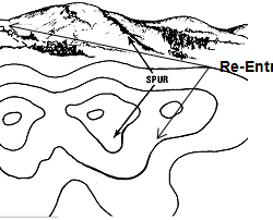
10 Mountain features that must be a part of any trekker’s vocab!
Ritvij Kumar 25 March 2017
MOUNTAIN FEATURES THAT MUST BE A PART OF ANY TREKKER’S VOCAB!
While the terminology used in mountaineering is decently complex but the features that I am going to talk about are mostly the common ones. When we go t
How to avoid and treat blisters on the Trek

How to select a perfect pair of hiking shoes

How to Pick High Altitude UV Protection Sunglasses

Campcraft Basics : How to Pitch a Tent

How to maintain Personal Hygiene on the trek
Experiential.

BARAADSAR LAKE: THE RABBIT OUT OF A HAT: A PHOTO STORY
Informative.

Tandiandamol : Perks Of Climbing The Road Less Traveled

Bucket List Treks For 2019

11 Best Offbeat Treks In India Nobody Knows About

Top 40 treks to do in India

Must Do Treks Near Bangalore
Enter your email, certifications.

Events by Month
- January July
- February August
- March September
- April October
- May November
- June December
Events by Activity
- Popular Treks
- Aspirational Expeditions
Events by Grade
Events by duration.
- 5 & more Nights
Bikat Adventures
- Environment Policy
- Privacy Policy
- Terms & Conditions
- Work With Us
- Address: 303, 3rd Floor, Tower B4, Spaze Itech Park, Sector 49. Gurgaon
- Pre Sale - 8448680062 , Post Sale - 8588878499, 9667639126
- Cancellation & Refunds
- Content Sharing
We are Social
Payments we process, submit enquiry.
Tadiandamol Peak
₹ 5,550 onwards
Tags : Hills & Valleys
Trek Duration : 2-3 hours one way.
Difficulty Level : Moderate. Not recommended for amateurs.
Distance : 1.3 km one way
Planning a Trip? Ask Your Question
Tadiandamol Peak, Coorg Overview
Tadiandamol is the highest mountain peak in Coorg, at an elevation of 1748m. Most tourists interested in trekking are drawn to this place as the journey is difficult, but the view from the top, unparalleled. While being the second highest peak in all of Karnataka, Tadiandamol trek is also a very good option for nature lovers who desire scenic surroundings and are beginners in the trekking scene. Apart from the treks, nature lovers can visit the place as almost half the journey can be reached by a vehicle.
Read More on Tadiandamol Peak
Food availability, water availability, tips and tricks, accommodation, trek routes.
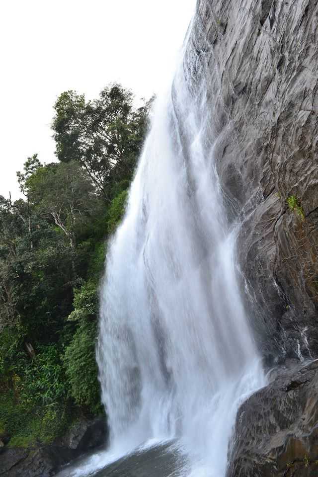
How to reach Tadiandamol Peak
Rail: Numerous trains are available from every possible location to Bangalore and Mysore, even Vijyapet for that matter. After reaching one of these start-up points, you will have to arrange for a personal vehicle for the rest of the journey, or you could always opt for public transportation which is much cheaper and safer.
Road: The town of Kakkabe is approximately 250 kms away from Bangalore and 135 kms from Mysore. A car ride is a convenient and hassle-free option if you are aware of the area and the general region. After reaching the town of Kakkabe, the base camp is located a little further away near a big rock which is a major landmark of the trek. Many bus depots are also available for the journey from Virajpet which is 25kms to Kakkabe.
More about Tadiandamol Peak
Approx trek time : around 5-8 hours
Availability of night trek: N/A
Base Camp: located near a village named Kakkabe
Days required for the trek: 2 to 4 days
Difficulty level: Moderate
Height above sea level: 5740 feet
Nearest Airport: Mysore airport
Nearest Railhead: Mysore railway station which is somewhat 100 kms away from Kakkabe
Region: Coorg
Starting point of trek: Kakkabe; There isn't really a proper name for the base camp but it is a forest cover around 3 km away from the main town of Kakkabe
Type: Hill and forest type
Coorg Travel Packages
Compare quotes from upto 3 travel agents for free
Recharge in Coorg Tour Package
2 nights 3 days coorg getaway package, coorg adventure package with river rafting, magical coorg mysore tour package, coorg, mysore, ooty and kodaikanal tour, best selling coorg holiday package from bangalore, top hotel collections.

Best Hotels
Family Resorts
Luxury Resorts
Private Pool
Top Hotels Near Tadiandamol Peak
9.0 (301 reviews)
6 kms
₹ 18,530 onwards
8.8 (245 reviews)
9 kms
₹ 22,500 onwards
7.7 (143 reviews)
₹ 8,399 onwards
7.0 (32 reviews)
7 kms
₹ 2,978 onwards
Tadiandamol Peak Reviews
Have a question on tadiandamol peak.
Other Top Ranking Places In Coorg
Nearby places.
Related Posts
Sightseeing
The Scotland of India: Coorg
Things to do in Coorg
Waterfalls in Coorg Adding Magic to its Greenery
Places Near
Places To Visit Near Coorg For a South-Indian Holiday
Experiences
Trekking in Coorg for an Adventurous Experience
Coorg Trip From Bangalore
Shopping in Coorg - Best Things to Buy and Places to Shop
Elephant Trail Homestay - Live Amid a Coffee Plantation in Coorg
McLeod Ganj Of South India: Guide To Visiting Bylakuppe
Backpacking
2 Days Itinerary For Coorg - 48 Hours in Coorg and How to Make the Most of It
Weekend Escapade to Coorg!
Ultimate Road Tips: All You Need To Know About Riding From Bangalore To Coorg
Similar Places
Get the best offers on Travel Packages
Compare package quotes from top travel agents
Compare upto 3 quotes for free
- India (+91)
*Final prices will be shared by our partner agents based on your requirements.
Log in to your account
Welcome to holidify.
Forget Password?
Share this page
Tadiandamol Trek : The heart of Karnataka's Coorg
Embarking on the Tadiandamol Trek is a voyage into the heart of Karnataka’s Coorg district, where nature’s grandeur unfolds in a splendid display. At an elevation of 1,748 meters, Tadiandamol stands as the highest peak in Coorg, inviting adventure enthusiasts and nature lovers alike.
The trail begins amidst dense forests, where the scent of eucalyptus and the symphony of chirping birds accompany trekkers. As the ascent progresses, the landscape transforms, revealing sprawling grasslands and panoramic views of the surrounding hills. The trek is a gradual climb, making it accessible for both beginners and seasoned hikers.
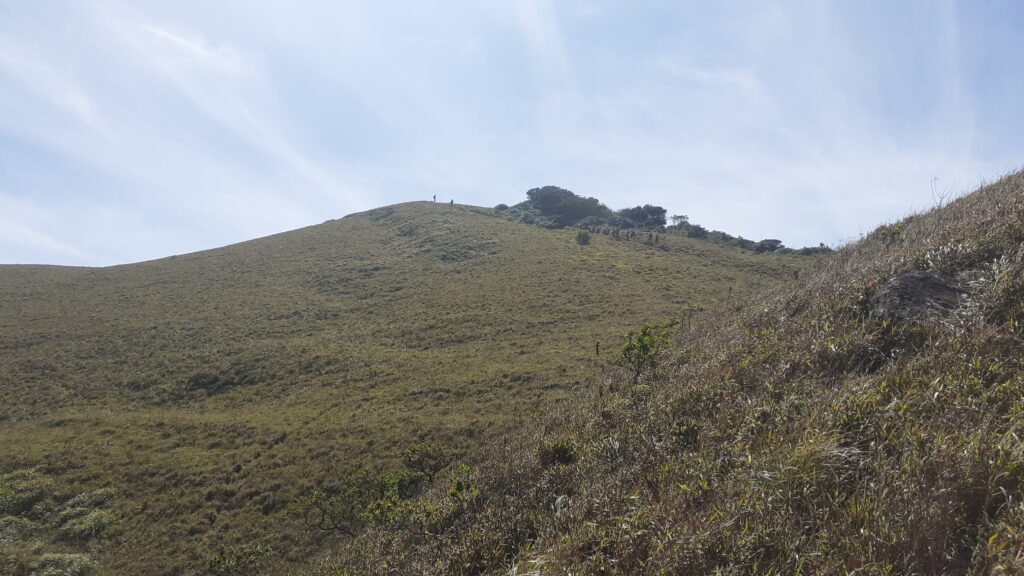
Reaching the summit is a triumphant moment, with the sight of the expansive Western Ghats stretching to the horizon. The cool breeze at the top, coupled with the breathtaking view of the Pushpagiri and Brahmagiri ranges, makes Tadiandamol a trekker’s paradise. The descent offers a chance to savor the serene beauty of the Big Rock, an iconic landmark along the trail.
The Tadiandamol Trek transcends the physical challenge, offering a profound communion with nature. It’s a journey that not only invigorates the body but also rejuvenates the soul, leaving indelible memories of the pristine landscapes and tranquil ambiance of Coorg’s crown jewel.
Upcoming Treks to Tadiandamol
- [email protected]
- Week end trip
About the Author
- Entries feed
- Comments feed
- WordPress.org
Tadiandamol trek
Thadiyandamol trek / tadiandamol trek information in details, location on google map:.
{google_map}12.217356,75.608768| type:terrain| show_info:no| zoom:14| width:1200 | height:480{/google_map}
How to reach from Bangalore:
If you are taking private vehicle then you can follow bellow route :
1) Bangalore –100Kms–> Mandya –26Kms–> Srirangapattana –20Kms–> Elivala–31Kms–> Hunsuru–45Kms–> Gonikoppa l–16Kms–> Virajpet–26Kms–> Kakkabe.
2) Bangalore—>Mandya—>Srirangapattana—>Mysore–>Hunsuru–>Kushalnagar–>Madikeri–>Kakabe.
Road condition of second route is better than first one.
Public Transport ( From Bangalore): Catch KSRTC buses to Virajpet from Satellite bus-stand . Then change bus to Bhagamandala, get down near Kakkabe (Aramane stop which is 2 Kms before Kakabe).
Tadiyandamol ( thadiyandamol ) Trek trail map
Mainly there are two trek routes. 1) Aramane / Palace route 2) Honey Vally route
Here is map of Aramane / Palace trek route. Peak is 8 Kms from main road(Main road is marked in Black colour).
If you are travelling by public vehicle : Get down just 2 kms before Kakabe (from Virajpet side). Get down just after zigzag curve. you can request to stop at Aramane/Palace stop. This is your starting trek point which is marked as “Trek starting point A” in above map. You required to walk 4kms the road which is marked in blue colour in the map.
If you are travelling by private vehicle : If you are travelling from Virajpet route then just before kakkabe you will hit zigzag road which is marked in black in above map. Take left just after zigzag curve. You need to proceed in the this road for another 4 Kms (which is marked in Blue colour). Park your vehicle here and this will be your starting point which is marked as “Trek starting point B” in map.
You will find small water stream here. You can fill water if you require. Route from here to foothill of the peak is around 2.6 Kms which is marked using “yellow line” in the map. This is mud road. Keep left in Y junction. This stretch is easy. After trekking 2.6 kms you will find big rock which is best place for Camping. You will find water source very much nearby. If you are planning to camp then this is best option. you will find plenty of wood for your fire camp. Wind will be much lesser than peak.
After this Big rock, peak is around 1.6 kms far. Trek trail is much steeper. This stretch is marked using “Purpule colour” in above map. you need to cross small stretch of sholla forest. Dont try to take any shortcuts. (We tryed out and missed our way for some time 🙂 ) Hardly 4 – 6 tents can accommodate in the peak. [Warning : On the peak there will be high speed wind. You check weather report just before going,] Just after rainy season finding wood for fire camp will be difficult, you need to carry this from base camp.
Tadiyandamol (Thadiyandamol) trek trek difficulty :
Stretch marked in blue line is very easy(4kms), Stretch marked in yellow line is easy (2.6Kms), Streach marked in Purple colour is Moderate.
Tadiyandamol peak height :
Tadiayandamol peak height is 1740 mts from sea level. This is second tallest peak in Karnataka . Tallest peak in Coorg.
Thadiyandamol trek trek distance :
You can find different answers in different blogs. Actually it depends on 1) which route you are taking 2)From where you are starting your trek. In Aramane/Palace route you can start your trek from main road which is marked as “Trek starting point A” in above map. Distance from “Trek starting point A” to Peak is 8 Kms one side. Trek distance from “Trek starting point B” to peak is 4 Kms .
Time to trek Thadiyandamol trek peak:
If you are starting from “trek starting point A” then it will take around 1-2 hour to cover initial 4Kms which is marked in blue color in above map. Next stretch is around 2.6 kms which is there till the foothill (till big rock) stretch is marked in yellow line in above map may take 1-2 hour . Last stretch is 1.4 Kms which is more steeper. It may take 2-3 hours. Total stretch from Trek starting point A to peak requires 4-7 hours one side. From Trek Starting point B to peak it requires 3-5 hours
Camping site at Thadiyandamol trek:
There are two best places for camp. 1) At the foothills of the peak that is near to the big rock. This is best place for camp. You will get water near by. Big rock gives you protection from water. Ground is flatter for camping. you will get wood for campfire. 2) At the peak. Only 4-6 tents will accommodate at the peak. So if you are trekking in long weekend then better reach early to the peak. But there is no water at the peak. so you need to carry. Normally high wind will be there at the peak so just check wind in weather forecast.
Warning : Please keep campfire overnight if you are camping at the foothills. This is because observed Elephants activity recently in this area
- +91 9611102222
- [email protected]

- Upcoming Treks Two Day Treks One Day Treks Karnataka
- Himalayan Treks
- We also offer Corporate Outings Member Registration
- About Our Company Our Social Responsibility Career @ BMC BMC Building a Team in Chennai Contact us

- Tadiandamol Trek, Coorg
- Need help for booking
- Upcoming Treks in Karnataka
- Upcoming Treks & Adventures
- Starting from Bangalore
- Two Day Treks
- Long Weekends
- New Year Treks
Any day in the “Scotland of India- Coorg” is better than a normal day in the city. If you are looking for a getaway that yells beauty, serenity and one of a kind experience then look no more.
Tadiandamol Trek stands at a height of 5700ft, located at a distance of 8 km from the town of Kakkabe and approximately 35 km from Madikeri.It is the highest peak in Coorg and is situated in the south-eastern part of Coorg.
We reach Coorg at dawn, the fresh aroma of coffee estates that span as far as your eyes can possibly see offer us a warm welcome. After a quick breakfast we start from Nalakanad Palace. the trek route has numerous visual treats for you guys in store. From seeing pretty butterflies, to waterfalls that are of just the right size to enjoy, to jaw dropping views of the valley. Tadiandamol is a MUST for everybody who choose NATURE over Netflix.
After about 4kms of walk we reach BIG ROCK that will serve as a point of rest before we continue towards the peak. The path then tests you with gradual increase in the inclination, this where you come across the famous shola jungle.
But nature has a trick up her sleeve, we come up to a false peak which deceive many people who end up thinking that this is the peak. The trail thereafter becomes narrow and steep, which makes even a distance of just 300m seem like a lot!
The top is usually covered in low, moving clouds. After spending ample time and enjoying everything that the trek has to offer we have our packed lunch and enjoy the panoramic views, we begin our descent at a slow comfortable pace back to the base.
A short drive later we are back at our homestay for tea and snacks, followed by dinner and a blissful night’s rest. Next morning we wake up by 7 AM to freshen up and have breakfast, following which we will continue to the Golden Temple . We begin for Bangalore a little before noon and are likely to reach here by about 9PM in the evening.
Overall, Tadiandamol offers enchanting views while at the same time not demanding too much physically (in comparison to treks such as Kumara Parvatha, Mullayanagiri/Bababudangiri, etc.), which makes it the perfect initiation trek for anyone looking to take up trekking seriously.
- Difficulty level : Easy to Moderate
- Trek Length : 14 Kms in total (Two way)
- Altitude : 1748 Meter
- Distance from Bangalore : 260 Kms (One Way)
- Minimum Age : 8 Years
- Weather : 24 to 28 Degrees (March to June)
- Attraction : Beautiful Mountains and View Points.
- Transport : Non AC Private Coach
- Food : Veg & Non-Veg Food
- Washrooms : Only at Base Camp
- Accommodation Type : Dorms separate for Male & Female
Few important points to note before you decide to register:Click Here
What is included in the tour
- Non A/C private coach from Bangalore to Bangalore
- Accommodation in Dormitory or Tents (separate for Male & Female)
- 2 Breakfast (Veg)
- 1 Packed Lunch (Veg)
- 1 Dinner (Veg & Non-Veg)
- 1 Evening Snacks
- Forest Permission
- Instructor from BMC
What is NOT included in the tour
- Any food during the journey
- Anything not mentioned in Inclusion
Note: There is a different permission charge for Foreigner & the difference amount should be paid by the participant on spot
PACK LIGHT, CARRY ONLY WHAT IS NECESSARY
- Personal Medication (if any)
- Strong Backpack (Preferably water proof)
- Fresh pair of clothes for two days.
- Empty Lunch Box
- Toiletries.
- Water bottles (at least 2 liters of water)
- A torch with new batteries (must in case of emergency)
- You can carry Energy Food (Chocolate bars, flavored milk, Electrolyte drinks - Glucose etc.)
- Sunglasses, Sunscreen.
- Camera (Optional)
- Rain Coat (Highly Suggested)
- Trekking Shoes (Highly Suggested)
Tentative Schedule:
Day 1 22:00 PM - Pick-up from BMC, office Indiranagar 22:15 PM - Pick-up from Domlur Sky Walk, Opp to Domlur Bus Stop 22:30 PM - Pick up from Sapphire Toys, Richmond Road (Near Sacred Heart Church) 23:00 PM - Pick-up from RR nagar arch
Day 2 01:30 AM - Pick-up from Srirangapatna Bus stand (Mysore) 05:30 AM - Reach base camp, Freshen up & Have Breakfast 09:30 AM - Proceed for the Trek to Tadiandamol Peak. 12:00 PM - Reach, rest and have lunch 13:30 PM - Trek down to base & Depart to the campsite 16:30 PM - Reach campsite - Freshen up - tea/coffee/snacks 20:00 PM - Enjoy Campfire & Have dinner and retire for the day
Day 3 07:00 AM - Freshen up - Breakfast 09:00 AM - Start back to Bangalore 10:00 AM - Visit Chiklihole Dam with Golden Temple or Dubare Elephant camp. have self sponsored lunch on the way 20:00 PM - Reach back to Bangalore
Route Map for Pick up & Drop Points: https://goo.gl/maps/uRnLtF4VPkQ4D75G8 Note: Drop points will be the same as pick-up points.
Loading the map...
- INCLUSIONS/EXCLUSIONS
- THINGS TO CARRY
- PICKUP POINT
OTHER POPULAR TOURS

Kudremukh Trek

Uttari Betta Day Trek

Netravati Peak Trek, Chikmagalur
OTHER ACTIVITIES

- Dispute Resolution
- Privacy Policy
- Terms & Conditions
- Cancellation Policy

Tadiandamol Trek

Fitness Regime for your Western Ghats Treks (Comprehensive plan to make you fit for any trek in 4 weeks)
Tadiandamol Trek is on a standout among the most delightful, noncommercial peaks of Karnataka, it is raised to around 1748 m and known as the most astounding crest in Coorg/Kodagu locale. The Tadiandamol trek offers globe-trotters a chance to experience the dazzling vegetation, uncommon mountain flying creatures and lovely butterflies fluttering from tree to tree. A panoramic view from the peaks is an eye-candy for the hikers. The preliminary takes you through the tremendous spread of the Shola backwoods, Tadiandamol Trek is day trek which makes it considerably progressively possible for city people whether enthusiastic trekkers and explorers. An acclaimed chronicled milestone “Nalknad-Palace” dwells at the lower regions of the mountain.
Short Itinerary
- Start from Bangalore
- Reach Bhagamandala
- Get ready for trek at homestay
- Jeep ride to Nalknad Palace
- Hike to the base of Tadiandamol
- Trek to the peak
- Return to base
- Jeep Ride to Homestay
- Visit to Namdroling Monastery (Golden Temple)
- Back to Bangalore
Price Inclusions
- To and Fro journey
- Accommodation
- Two breakfasts (Saturday, Sunday)
- One lunch (Saturday)
- One dinner (Saturday)
- Snack/Power packs for trek
- Lots and lots of FUN.
Price Exclusions
- Lunch(Sunday)
- Dinner (Friday/Sunday)
- Any kind of insurance
- Personal Expense:( snacks, mineral water etc)
- Anything not included above
- Sharing basis accommodation
- Separate accommodation for boys and girls
- We offer hot vegetarian food.
Transportation
- Non-A/C Tempo Traveller or Mini-bus with push back seats depending on group size
Pickup Points
- Koramangala Water Tank | 7.30 PM | (Sarjapur Main Road, Near St. John’s Hospital)
- New Shanti Sagar Hotel | 8.15 PM | (HAL Road, Near Domlur Bridge)
- MG Road | 9.00 PM | (Hard Rock Café, near Anil Kumble Signal)
Detail Itinerary
Detailed itinerary of tadiandamol trek, day 0: departure from bangalore, day 1: tadiandamol trek.
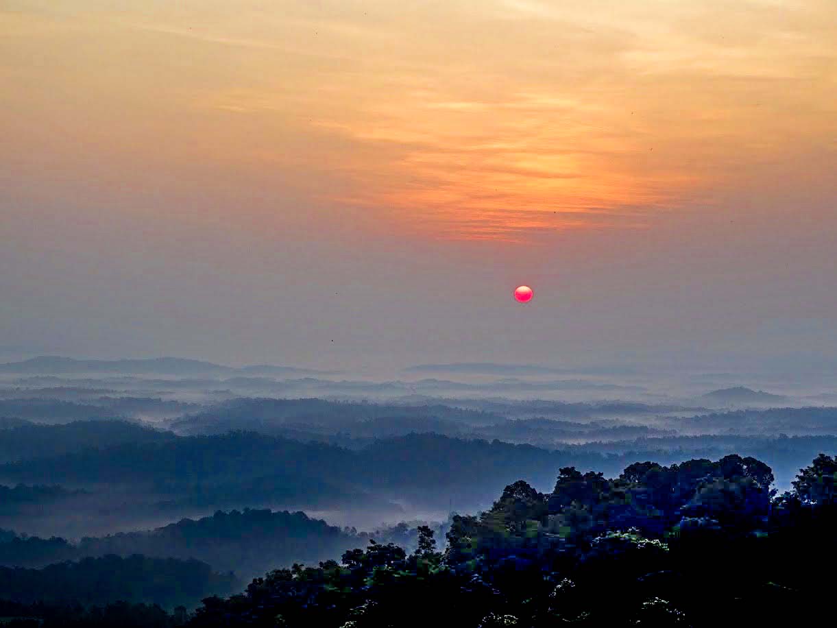
Day 2: Return back to Bangalore
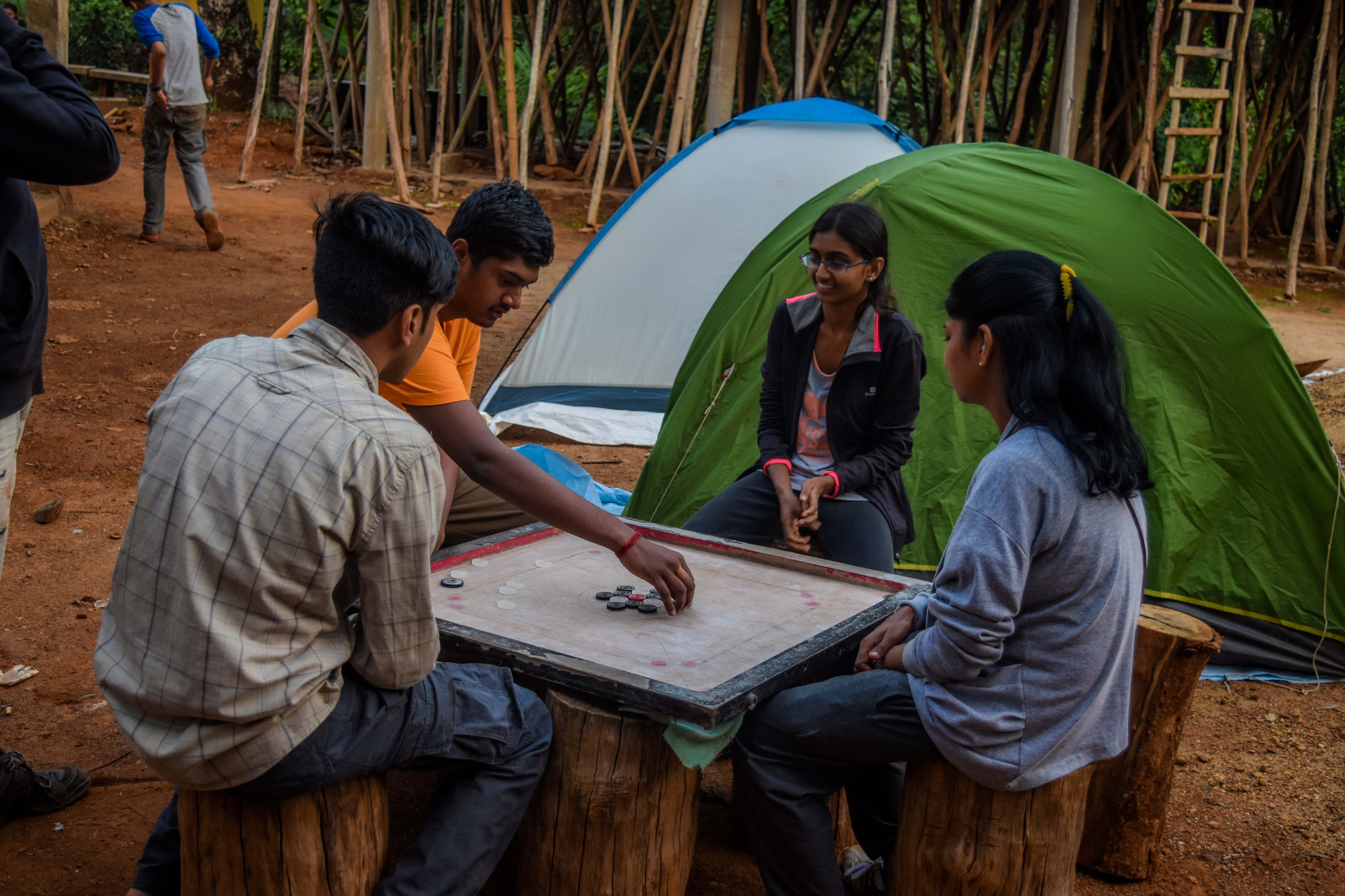
Things to Carry
Mandatory things to carry.
- Xerox Copy of you Aadhar/Voter ID (Mandatory requirement for forest permit)
- Water Bottle – 2 (1 liter each)
- Raincoat – if in case it rains.
- Torch with New Batteries
- Shoes with good traction on it.
- One cover sheet – Good to have one
Other Things to Carry
- Cargo/track pants -2
- T-shirt -2
- Extra pair of Socks
- Personal medication kit
- Toothpaste
- Toothbrush
- Rain Coat/Poncho
- Flip-flops
- Portable chargers
- One bag to keep wet cloths
- Little extra cash for meal not included in the itinerary
Refund & Cancellation
- https://naturewalkers.in/cancellation-policy/
- you can send your cancellation request to [email protected]
Safety,Risk and Advisory
Safety at nature walkers.
- Please carry Xerox copy of Pan Card or Aadhar Card, as its same is required to permission from the Forest Department.
- Non – Indian nationals will have to pay additional cost of Rs. 1300/- toward forest permission.
- We strictly DO NOT ALLOW consumption of Alcohol, Beer, smoking or intoxicants on out trek. We request you to please co-operate with us to the make the experience more enjoyable.
- Requesting our participant to DO NOT EXPECT any kind of luxury on the trek. We host our treks in remote location and do our best to arrange the basic necessary facilities for our participant. The objective is to experience the local outdoor.
- We provide hot vegetarian food on our treks. If in case we can arrange Non-Veg, we would inform you on the trek.
- DO NOT wear tight pants; tight pants are not comfortable for treks as the leg motion is restricted.
- DO NOT carry valuable ornaments; it can cause unnecessary trouble if misplaced. (Nature Walkers do not take any responsibility of your ornaments).
- DO NOT wear black or dark cloths and perfume on the trek (as some insects get attracted to dark color and perfumes)
- Please put the little at its place, we request to not trash the trek or the accommodation facility.
- If in case of traffic delay, we request our participants to expect little delay in reaching the destination.
- 8 to 20 Members
- We get equal boys to girls ratio for most of our treks/trips
- We require a minimum of 8 participant to confirm the event
- If in case, we fail to obtain the required minimum number of participants. We would initiate full refund or transfer to another event for the same departure date. (Option of transfer shall be subject to payment/refund of balance amount if any)
What are the COVID Guidelines for the Trek?
What are the good treks or trips to do in march and april 2021.
- Kashmir Backpacking Trip
- Sandakphu Trek
- Goechala Trek
- North Sikkim Backpacking Trip
- Munnar Meesapulimala Trek
- Brahmatal Trek
- Kedarkantha Trek
I am Solo Traveler, Can I join?
I am first time trekker/traveler, will the trek/travel be difficult for me, i am women/girl. is the trek/trip safe for me, if you have more questions, please check our “ frequently asked question ” (or) ask in the comment section..
- Reviews (22)
22 reviews for Tadiandamol Trek

Harish Reddy S – February 18, 2020
Review for TADIANDAMOL TREK ★ ★ ★ ★ ★

Haritha Sukumar – February 17, 2020

Sharmili – February 17, 2020

Suba (verified owner) – February 17, 2020
My friend suggested me nature walkers, I have been on few treks before this one, but the leaders were not this much encouraging and supportive.. The patience level of Lingaraj and Ajith was high and they were super cool. It was a well planned and organised trek.
Sharmili Rajeshkumar – February 17, 2020
This is my first trek with my frds as a grp of 5 girls.. We just had a rough idea about the trek surfing through all the youtube videos but on the start of the trek it was really exciting and thrilling walking through all the greenery admiring everything off course the trek was tiring by the end of the day, but it was a lifetime experience and the odl’s and fellow trekkers were vry supportive without their support and motivation this could have not been possible.. Wishing to do some more adventurous treks like this!

Niharika – January 4, 2020
It was second and unplanned trek for me with Nature walkers, though it gave me such an awesome experience. The homestay was good with all the required aminities and as the food was prepared at home it was fresh and tasty. On 28th Dec, the day we have done our trek it was bit sunny but our trek lead Ajit was so supportive and encouraged us in completing the trek successfully. After trek we enjoyed our bonfire and next day we covered monastery. In return journey we enjoyed playing dumb charades. Overall its a wonderful experience. Thanks Nature walkers.
It was unplanned trek for me though it gave me such an awesome experience. The homestay was good with all the required aminities and as the food was prepared at home it was fresh and tasty. On 28th Dec, the day we have done our trek it was bit sunny but our trek lead Ajit was so supportive and encouraged us in completing the trek successfully. After trek we enjoyed our bonfire and next day we covered monestry. In return journey we enjoyed playing dumb charades. Overall its a wonderful experience. Thanks Nature walkers.

Atul Yadav – December 31, 2019

Poonam – December 31, 2019

Sumithra – December 30, 2019
This is my second trip with Nature Walkers and I throughly enjoyed the trip.. Recommend everyone to plan your trips with nature walkers.. the homestay was neat and clean ; food provided at homestay was also good.
Special thanks to our Trek Lead Ajit Yadav for managing everything properly and in professional way. You have been the best guide and easy to go person. Me and my frds enjoyed your company and looking forward for many more trips with you and Nature Walkers.

Akshaya Manogaran (verified owner) – December 16, 2019
Tadiadomal happened to be our second trek with Nature Walkers. We travelled all the way from Chennai for the trek, and it’s worth the effort. The trek was perfectly organised and intact in all ways. The transportation was comfortable, home stays were really too good. We got to have Shailesh and Shashank as our ODLs. They made sure nobody loses the vibe and synch in the group. They motivation levels were super high and had super cool approach on things. One another awesome memory updated, taking back all good energy and lots of new bonds! Thank you team Nature Walkers for the initiation✨

Dharmesh – December 15, 2019
This was my first trek with Nature Walkers. And what a memorable trip is was.. From the very beginning, the team management, by our leads Shashank & Shailesh, was amazing. They handled everything perfectly.. from encouraging us to not give up.. to making sure everyone reach the peak.. and continuously interacting with us.. and of course having fun along the way. Trust me, the feeling of finally reaching the peak and the view from the top cannot be described in words. You have to see it to believe it. Could have stayed there for hours. The homestay was decent, loved the food, and the next best thing after trek was the bonfire.. having interaction with everyone was great. Everything was well planned and the places we visited the next day were nice. Overall, had a wonderful time. Definitely going to do another trek with Nature Walkers now. Strongly recommend!!

Naveen – December 2, 2019
Did the trek during a weekend. It was a real stress buster from the normal routine life. The iterniary was well organised and spot on. Organisers Ajit and Sailesh were very accomodating and were with us all the way. Met a lot of new and interesting people. Couldn’t have asked for a better way to spend the weekend. 🙂

Vasanth – November 27, 2019
I went to this trek with my sister in November 2019. It was such a wonderful experience that it cant be expressed by any linguistics. You have to experience it yourselves to understand what I mean. It was very well organized from start to end, you will have no regrets about the transport, food and the stay.
My Full Credits to the Nature Walkers team ( especially to Kartik and Swapna who were the team leaders ) for guiding us, inspiring us to push forward and entertaining us with their great trek experience stories & fun activities. Most Important is their friendly attitude during the whole trek which made us really comfortable to coordinate with others and ease us as well. I am not a very social guy, yet I was guided to break my comfort zone which I feel was great.
I also liked the food they provided for us, it was vegetarian and it was actually very good, I feel lunch and dinner were the best because after reaching the peak you will be so happy, the lunch will taste “wow wow!” and then after completing the trek, you will freshen up and the dinner will taste more “wow wow wow”!. Experience it yourselves 🙂
And finally to end this review, when you feel you are stuck halfway during the trek, don’t worry, your team is there to push you and also remember that the board with 0 Kms will not disappoint you, so push till the end. Cheers!

Ramya – October 22, 2019
This was my first trek , which is made into an amazing memory of my life by nature walkers organization. I loved and enjoyed each and every moment in the trek. Thanks to all three ODLs Shailesh , Lavanya and Prajwal who made it easy for us by their guidance . I never felt they (ODL) are strangers , they took care of us like their family . They tried to give as much luxury and comfort possible to make the trip amazing for everyone . Looking forward for another trek with these guys.
Ramya R – October 21, 2019

Deepika V – October 15, 2019
Had a great time with Nature Walkers. The entire trek was well organised. The ODLs Shailesh , Lavanya and Prajwal did a great job in guiding us throughout the trek and ensured our safety.

Shruti Dogra – September 7, 2019
My first ever trek…it was pretty amazing and an incredible overall experience.I came solo but ended up having friends.Thankyou so much Nature Walkers for giving me such an amazing experience.Great work done by both the leads Karthik n Shailesh.Special thanks for them for making it such a memorable trek.

Anshuman Damani – September 6, 2019
One of the most incredible trekking experiences. It is a gathering of all solo wanders commencing their journey as strangers but ending it with a camaraderie unseen. Our ODLs Shailesh and Karthik were amazing, full of life and the amount of fun we had on the trek, on the excursions or even on during the bus ride was magnanimous. Thank you Nature Walkers, will be joining you soon again 🙂

swatilekhakar (verified owner) – September 3, 2019
Tadiandamol Trek was my 2nd Trek with Nature Walkers. It was well planned and organized. A special thanks to the Outdoor Leaders Kartik and Shailesh. You guys were very supportive throughout the entire journey and you were always there to help us. We came to the Trek as different groups but at the end it was one single group, which is a great thing. The entire trek path was very beautiful and it was full of greenery. The top view of Tadiandamol was mesmerizing! Apart from the Trek, we visited a few places like Raja’s Seat Park, Nalknad Palace, Chiklihole Reservoir and Golden Temple. During the trip, the ODLs arranged a few interesting games. On our way back to Bangalore, we were dancing on songs, and had a lot of fun. Further, the treks arranged by Nature Walkers are absolutely safe for the solo Female travelers. In fact, there were many solo Female travelers in this trek and they did not have any concern related to safety. Overall, it was an amazing experience. Cheers to the entire team of Nature Walkers!!! You guys are doing a fantastic job. Keep the spirit high. Looking forward to go to the next trip with Nature Walkers ASAP. 🙂

Karthika – September 2, 2019
It was my first trek with nature walkers and I don’t know anyone in the group. But while completing the trek, I came to know everyone in the group who came with us. It’s really safe for solo female trekkers.
They organized really well and they are very much friendly to everyone in the trek. While returning, we haven’t expect that the trek ends so soon. When we reached the top, it rained heavily. But, it was a very good experience and such an awesome trip.
NatureWalkers kudos to you!!👍👍😊

Kiran Kumar S (verified owner) – June 26, 2019
Went alone for this trek on 22nd June 2019. It was an awesome trek in monsoon rains 🙂 Very well organized. Outdoor leaders Karthik/Lingaraj were great/witty. Lucky that we also had very friendly fellow trekkers, didnt feel lonely. After trek, we had great fun at campfire with games/antakshari which went on till midnight. Homestay was decent and home cooked food was good.
Looking forward to more treks with NatureWalkers.
Your email address will not be published. Required fields are marked *
Name *
Email *
Save my name, email, and website in this browser for the next time I comment.
Your review *
Price: ₹ 3,600.00 ₹ 2,999.00
- Booking Form
- Enquiry Form
Book the tour
Travel Date
Select the Pick Up Location
Fill up the form below to tell us what you're looking for
Facebook Reviews
Tadiandamol Peak

Top ways to experience nearby attractions
Most Recent: Reviews ordered by most recent publish date in descending order.
Detailed Reviews: Reviews ordered by recency and descriptiveness of user-identified themes such as wait time, length of visit, general tips, and location information.

Tadiandamol Peak - All You Need to Know BEFORE You Go (2024)
- (0.00 mi) Coorg Heritage Inn
- (0.27 mi) Spring Dale Villas
- (1.08 mi) Club Mahindra Virajpet, Coorg
- (5.83 mi) The Tamara Coorg
- (8.29 mi) Avadale Coorg (Stag Groups Not Allowed)
- (1.07 mi) Aromas by Club Mahindra Virajpet, Karnataka
- (1.10 mi) Coorgenburg by Club Mahindra
- (1.40 mi) HAVELI RESTAURANT "THE BAMBOO PARADISE OF COORG "
- (8.44 mi) Secret Spices RestOCafe
- (3.72 mi) Basho Restaurant
- (0.00 mi) Kabbe Hills
- (0.00 mi) Karada
- (4.41 mi) Chelavara Falls
- (7.86 mi) Igguthappa Temple
- (6.47 mi) Nalknad Palace
A day trek to Tadiandamol

Tadiandamol is highest mountain of kodagu/ Coorg District. Ideal trek for first timers, beginners and moderate trekkers.
136kms drive from Mysore. 263kms from Bangalore. One day or half day trek. 7-8 Kms two way distance which would take 3-4.5 hours. Suggested to go in the spring or rainy season. Start Trekking as early as possible since it will be tiring to trek once the sun rises.If you reach the top early, you will be lucky enough to witness sunrise between mountains. There's a check point by forest department of Karnataka which charges nominal fee of 20rs per person were your basic details of name, mobile number and address are noted and they make sure you sign once you reach back. That's good thing about safety. I suggest not to dispose any plastic during the trek and it's always advised not to carry plastic during trek. Save nature. It's ours.
Plan for the weekend was to reach Kodachadri hills, the darkest place in South India with motor cycle touring club named Enfield Monsters MTC based in Mysuru. My bike's broke down, I couldn't join the ride. As a rider and traveller, it really feels bad for missing such place, Tadiandamol was in my mind from quite sometime. So decided to reach there Saturday night on my RE classic 350, 136 Kms drive from Mysuru. The road to Tadiandamol is quite good but the way to the cottage is off-road for about 0.5 Kms, most of the cars I noticed were parked just before that tough road, since I enjoy such trials, managed to reach the cottage safely after few jerks. There's a little chance to fall off the bike if first timers. This was my solo trip for the first time ever. Had stayed at a cottage called west wind cottage, Tadiandamol. Had dinner at the cottage and slept off so that I can start off early in the morning.
I had never expected the cottage guys would wake me up with a bed coffee and as promised by Kumar Anna(Helper at Cottage) last night, he woke me up at 530 and asked me to start as early as possible with Water bottle and preferably less luggage. Then comes the beauty of the trip, I knew Coorg is an awesome place but never expected it to be this wonderful. Since I started alone I was worried in the beginning. I almost reached half way (4-5 kms one way). Was little scared since I couldn't see any one until I reached the top, was even worried if it was the right way. Seeing few people I felt relaxed and continued my journey. Met few beautiful people from Mysore and Bangalore. From then I continued with those group of people till the end of my trek. It was around 7-9 Kms two way, which took us 3-3.5 hours. Once the trek is done, you still have half a day to explore places like dubare elephant camping and river rafting near khushalnagar on your way back to Mysore or Bangalore.
Place to stay:
I would strongly suggest the cottage West wind, which is the closest place to stay from the starting point if the trek, please don't miss the early morning view of coorg town . This view point would be found when you just step out of the cottage's entrance. The cottage has enough space to park 2/4 wheeler vehicles. The highlight of he cottage is the campfireire and the home food they serve (which includes in the package itself). Charge at the cottage was 1000 rs which included accommodation and food for 3 times in a day.
Contact : +919483393897 West wind cottage ( Google for directions)

West wind cottage, Tadiandamol

Tadiandamol Hills
IMAGES
VIDEO
COMMENTS
Trek Distance: 2 km Trek Duration: 55 minutes GPS coordinates of Nalknad Palace: 12°14'07.7"N 75°38'23.7"E GPS coordinates of Base of Tadiandamol: 12°13'54.9"N 75°37'48.9"E The trek now takes a more gentle ascent through a mud and gravel section from the Nalknad Palace to the base of Tadiandamol, where the actual trekking trail starts from.
The distance from Nalknad palace till Tadiandamol base camp is about 6 kms. There are also jeeps available that take you till the base camp from the starting point. So, taking the jeep till the base camp significantly reduces your hiking time. However, this trek gets extremely tricky during the monsoons.
Trekking: Trekking from Nalaknad Palace till Tadiandamol peak is a popular adventure activity in Kodagu. The Tadiandamol treeking trail is about 7 kms one way, categorized as 'Easy' and can be completed in one day. Camping is not allowed on Tadiandamol, hence trekkers need to return before sunset. Trekkers will be treated to blissful views ...
Tadiandamol, the highest peak of Coorg situated at 5735 feet, is a trekking spot 275 Kms from Bangalore. It is one of the best Western Ghats treks situated in Karnataka. It is the highest peak in Coorg and stands at an altitude of 1,748 meters (5,735 feet). The trek offers stunning views of the surrounding landscapes, including the rolling ...
Best Time to trek Thadiyandamol trek peak: November - Feb If you are starting from the "base next to the public bus stop then it will take around 1-2 hours to cover the initial 4Kms. Next stretch is around 2.6 km which is there till the foothill (till big rock) stretch may take 1-2 hours. The last stretch is 1.4 Kms which is steeper.
The only thing to keep in mind is that this trek has steep terrains right from the very beginning which makes it slightly challenging. The total distance of the trek is 12 KM, to and fro from the base point at Nalknad Palace. You can cover the entire distance in 6-7 hours depending on your pace.
Saturday. 6:00 am - 6:00 pm. Sunday. 6:00 am - 6:00 pm. Links: Website | Map. Improve This Listing. With a height of approximately 1746 meters above sea level, Tadiandamol is the highest peak of Coorg district of Karnataka. It is the second highest mountain in Karnataka state. Located at a distance of 8 km from the town of Kakkabe and ...
Explore the Tadiandamol Trek, a beloved journey in the Western Ghats, popular among both novice and experienced trekkers. It stands as the highest peak in Kodagu district and the third highest in Karnataka. Nestled in the Brahmagiri Wildlife Sanctuary of the Bhagamandala Range Forest, this trek treats you to dense shola forests, charming stream ...
As part of its never-ending beauty and wonders, Coorg brings to you its highest point: Tadiandamol, a trek at an altitude of 5735 feet. This stunning peak is surrounded by the greenery and expanses of the Shola forests, which are broken by the beautiful blueness of the water bodies that cut through it. The word Tadiandamol in Kannada means a big mountain, which is what it exactly is.The ...
Tadiandamol is the highest peak in the Coorg or Kodagu district of Karnataka. At an altitude of 5,735 km, the trek offers a panoramic view of the lush green hills. This stunning peak is surrounded by the greenery and the vast expanses of the Shola forests, seldom interrupted by the dazzling blueness of the water bodies making their way through it.
About Tadiyandamol/ Tadiandamol. Tadiandamol or Thadiyandamol is the highest mountain of (Madikeri taluk) Kodagu district, Karnataka, India. It is the third highest peak in Karnataka (after Mullayyanagiri & Kudremukha). It is located Western Ghats range, and reaches an elevation of 1,748 m. The mountain has patches of shola forests in the valleys.
Tadiandamol Peak, Coorg Overview. Tadiandamol is the highest mountain peak in Coorg, at an elevation of 1748m. Most tourists interested in trekking are drawn to this place as the journey is difficult, but the view from the top, unparalleled. While being the second highest peak in all of Karnataka, Tadiandamol trek is also a very good option for ...
The cool breeze at the top, coupled with the breathtaking view of the Pushpagiri and Brahmagiri ranges, makes Tadiandamol a trekker's paradise. The descent offers a chance to savor the serene beauty of the Big Rock, an iconic landmark along the trail. The Tadiandamol Trek transcends the physical challenge, offering a profound communion with ...
The mountain is located 37 kilometres from Madikeri. Height: 1748 m. Location: Tadiandamol, Yevakapadi, Karnataka, 571212, India. Best Time to visit: December to May. Entry fee: No entry fee. Timings: 6 AM to 6 PM on all seven days of the week. Average time required to visit the place: The trek takes around 5 to 6 hours.
Tadiandamol trek distance: 4 KMS (one side) Tadiandamol peak height: 1740 m: Time to trek: 6-8 hours: Camping site: At the foothills of the peak( a huge rock ) Best time to trek: Oct to Feb: Permission: Not Required: Trekking fees: Nil: Contact Number: NA: Thadiyandamol trek / Tadiandamol trek Information in details
Tadiandamol Trek stands at a height of 5700ft, located at a distance of 8 km from the town of Kakkabe and approximately 35 km from Madikeri.It is the highest peak in Coorg and is situated in the south-eastern part of Coorg. +91 9611102222 ... Trek Length : 14 Kms in total (Two way)
Tadiandamol Trek is on a standout among the most delightful, noncommercial peaks of Karnataka, it is raised to around 1748 m and known as the most astounding crest in Coorg/Kodagu locale. ... your team is there to push you and also remember that the board with 0 Kms will not disappoint you, so push till the end. Cheers! Rated 5 out of 5.
After KP trek I executed Tadiandamol peak and successfully achieved. This trek me and my team ( 5 members team) completely depended on public transportation from bangalore to Kakkabe and from Kakkabe road it was Nataraja Service(Walk) till trek base which was more fun. ... Tadiandmol trek is moderate trek and one can do in single day ~6 hrs ...
The nearest airport and railway station, Mysore, is a 100 kms from Kodagu. KSRTC runs regular buses to Virajpet town from Bangalore and is well connected. One can also take an overnight bus from Bangalore to Coorg. ... tadiandamol trek distance, highest point in coorg, tadiandamol trekking, tadiandamol trek, coorg holiday packages from chennai, ...
Tadiandamol is highest mountain of kodagu/ Coorg District. Ideal trek for first timers, beginners and moderate trekkers. 136kms drive from Mysore. 263kms from Bangalore. One day or half day trek. 7-8 Kms two way distance which would take 3-4.5 hours. Suggested to go in the spring or rainy season.
If you are looking for an adventurous and thrilling escape in Coorg, then Tadiandamol Trek is the perfect choice for you. Tadiandamol is the highest peak of Coorg and offers a stunning panoramic view of the green hills and valleys. You can book this trek with Thrillophilia and enjoy comfortable tents, delicious meals, and expert guides. You can also celebrate New Year and Christmas with this ...